

MAG5035
-
Posts
6,078 -
Joined
-
Last visited
Content Type
Profiles
Blogs
Forums
American Weather
Media Demo
Store
Gallery
Posts posted by MAG5035
-
-
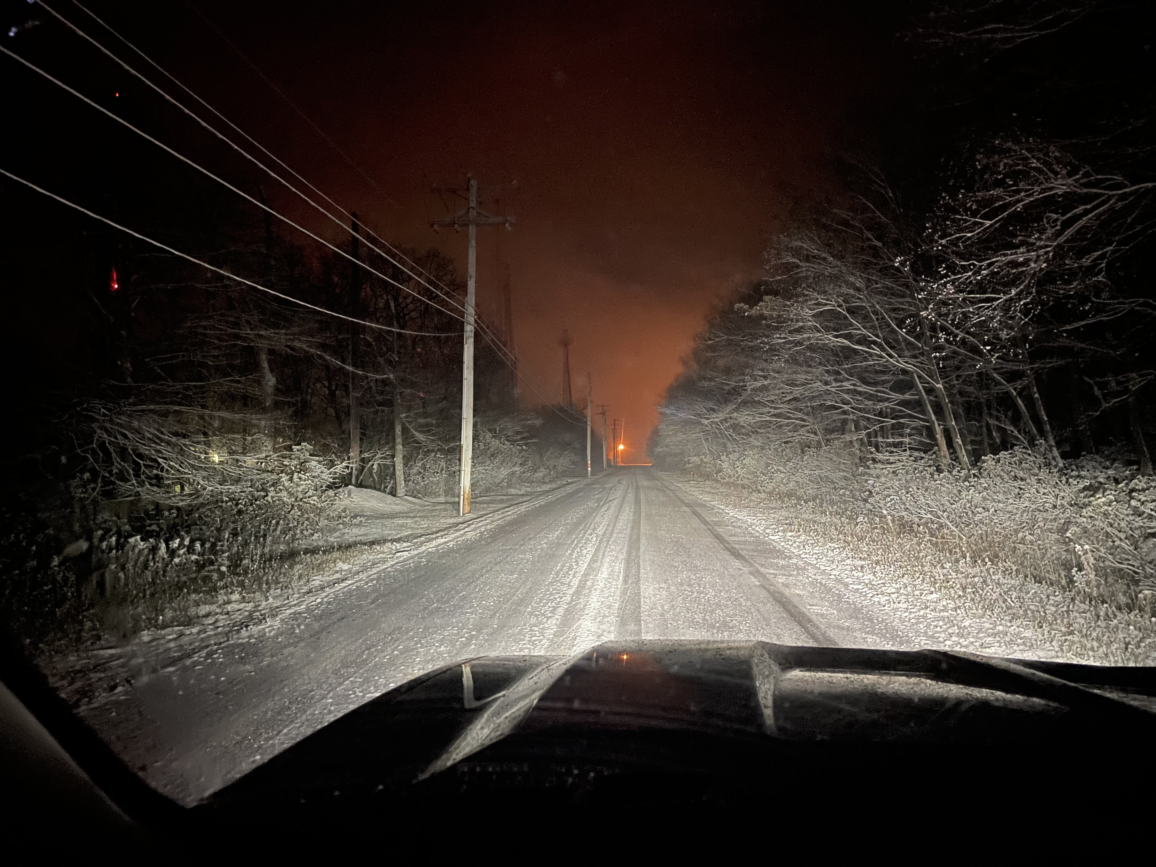
Some lingering light snow falling and 35ºF. Wasn’t home for the heavier precip earlier but it looked to have been a light car topper here.
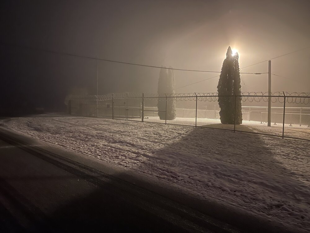
I did get my first official “roads caved” pic of the year at the top of Wopsy Mountain. Didn’t have a ruler with me but probably about 1.5” or so of wet snow up there in the grassy spots. Seemed like about 1500’ was where the switch flipped from a car topper to a coating+. There’s some light accumulation on the ridges east of Altoona as well. IMBY was just a couple hundred feet elevation too low for this one. Either way, good to see a wintry type event fairly early just getting to Mid-November. There was even some light WAA snow falling first thing this morning as well but temps were too warm.

-
 4
4
-
 1
1
-
-
Seeing the first flakes of the season mixing in up here at my hunting area on Tussey Mountain (NW Huntingdon Co)
-
1
-
-
Some thoughts on Sunday evening’s system.. It’s been a pretty consistent feature on modeling the last several days. This has a pretty good chance at delivering the first widespread bout of snow in the western half of PA and maybe into some of the central counties. It could have been for the rest of PA as well but the trend has been for models taking the low pressure through the lower lakes.. which will spell downsloping issues east of the Alleghenies and in general take the primary slug of precip up through western PA. I don’t think accumulations will be anything too significant, maybe up to a couple inches in the higher terrain. At any rate, winter is definitely upon us soon.
On a related note, how bout that 0z GFS coming in? I’ll take 36” of snow on the ground for Thanksgiving lol.
-
4
-
-
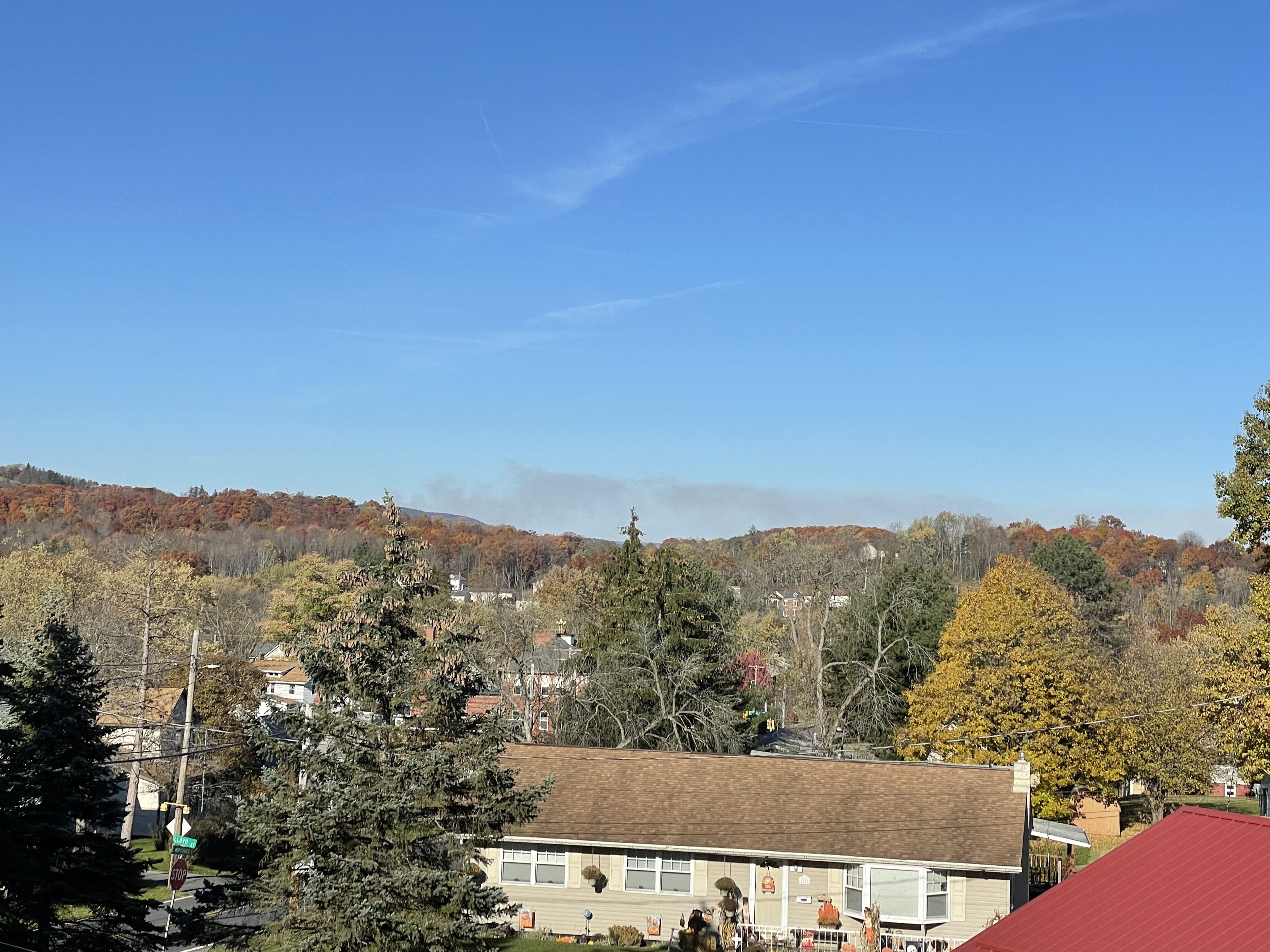
There’s some kind of fire up to the north of here today, visible on the regional satellite as well as from my house here. Looks like at the top of the Allegheny front somewhere above Tyrone or maybe a bit further north. Unsure if it’s an actual brush fire or controlled burn, haven’t seen anything on the news.

Shortwave IR
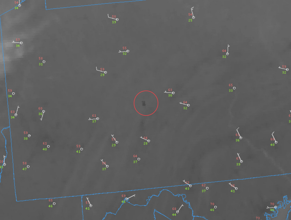
Visible

-
5 hours ago, Itstrainingtime said:
Honest question - who's the worst game day coach? Franklin or Tomlin?
I don’t usually get super fired up like the Facebook/Twitter coaching staff gets when either team doesn’t do well but I was def mad about having Boswell run a fake in a close game like that. Let your pro bowl caliber kicker do what he does best.
-
2
-
-
With regards to this week, I think the big story is going to be the marked change from October’s persistent warmth with this new pattern finally bringing C-PA a below average regime temp wise. As I mentioned last week, it appears we will be addressing the fact we haven’t had a widespread frost or freeze pretty directly to open up November. A weak disturbance Tuesday will likely deliver the regions first snowflakes at elevation as well.
I know there were some rumblings on the models of an end of week coastal but I think pattern’s a bit progressive to give us much from whatever materializes. Thus I think dry and chilly will be the general theme this week. Considering how far behind the leaves are I don’t know if I’d want an early season snowstorm quite yet.
Already some early strat-warming going on and associated disturbing of the PV. So that’s going to be interesting to see how it factors into how we open up the first part of the winter, specifically after say Nov 15-20th or so into December where snow threats become more doable if the appropriate pattern and cold are available.
-
3
-
2
-
-
It’’s been a brutal weather day around here as temps fell into the mid 40s by lunch time with periods of rain and gusty winds that have occasionally topped 30mph. Mesowest showing some upper 30s temps in some of the higher Laurel’s locations.
The raw weather has definitely illustrated how warm this October had been to date (especially with min temps) that we’re pretty much seeing the coldest temps of the month (high or low) in the midst of the first major nor’easter of the fall/winter vs a clear, cold radiational cooling morning. Looking pretty likely we’re exiting October at the end of the week with not even a widespread frost much less any kind of hard freeze for any part of C-PA. It does appear that we could be quickly addressing those cold weather things (and perhaps more in some parts of PA) within the first week or so of November, though.
It’s been a pretty wild month. Have to mention that NWS Pittsburgh now confirmed 11 tornadoes just in their CWA from that “marginal” severe threat last Thursday which has to be the most significant severe/tornado outbreak seen in that region for this time of the year. I can’t even think of a recent single severe event at any other point of the year that delivered so many tornadoes, and NWS Cleveland also had several confirmed as well. Might have been looking at May 31, 1985 similarities in terms of stronger tornadoes had that synoptic setup presented itself that time of the year (more heating/CAPE)
-
3
-
-
45 minutes ago, canderson said:
Is that line out west gonna survive the mountains?
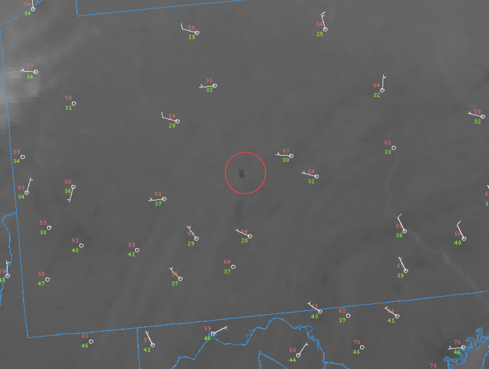
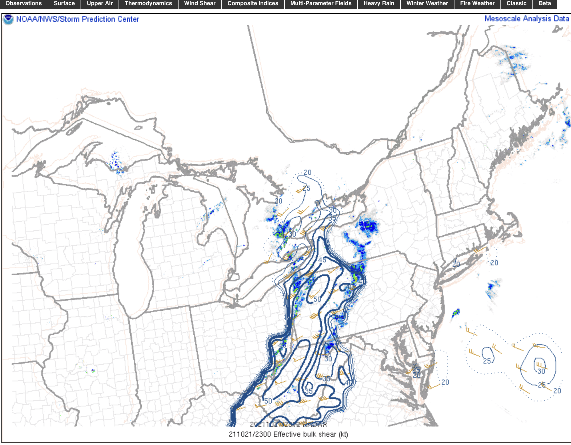
It’s likely that the severe aspect of the line likely won’t hold across the mountains. The big parameter with this line driving into western PA with what appears to be multiple couplets (probable QLCS tornadoes and/or wind damage) is nearly 50 knots of effective bulk shear in western PA. The SPC mesoanalysis near term forecast fizzles this parameter out later this evening, likely due to no CAPE east of the mountains (western PA has marginal CAPE present). But still wouldn’t rule out some gusty showers or storms though as this line out there is associated with the frontal passage/potent shortwave.

Also, I promise to post more as we get onward toward winter… I’ve been pretty busy lately. It’s nice to see so much activity in this thread these days.
-
8
-
-
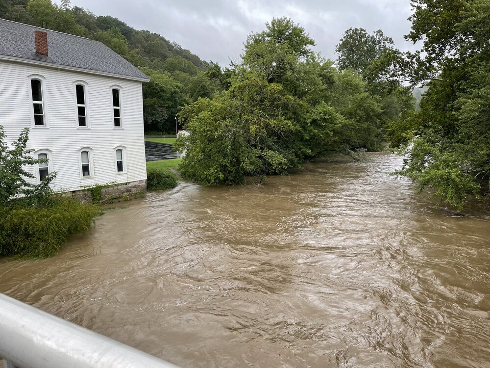
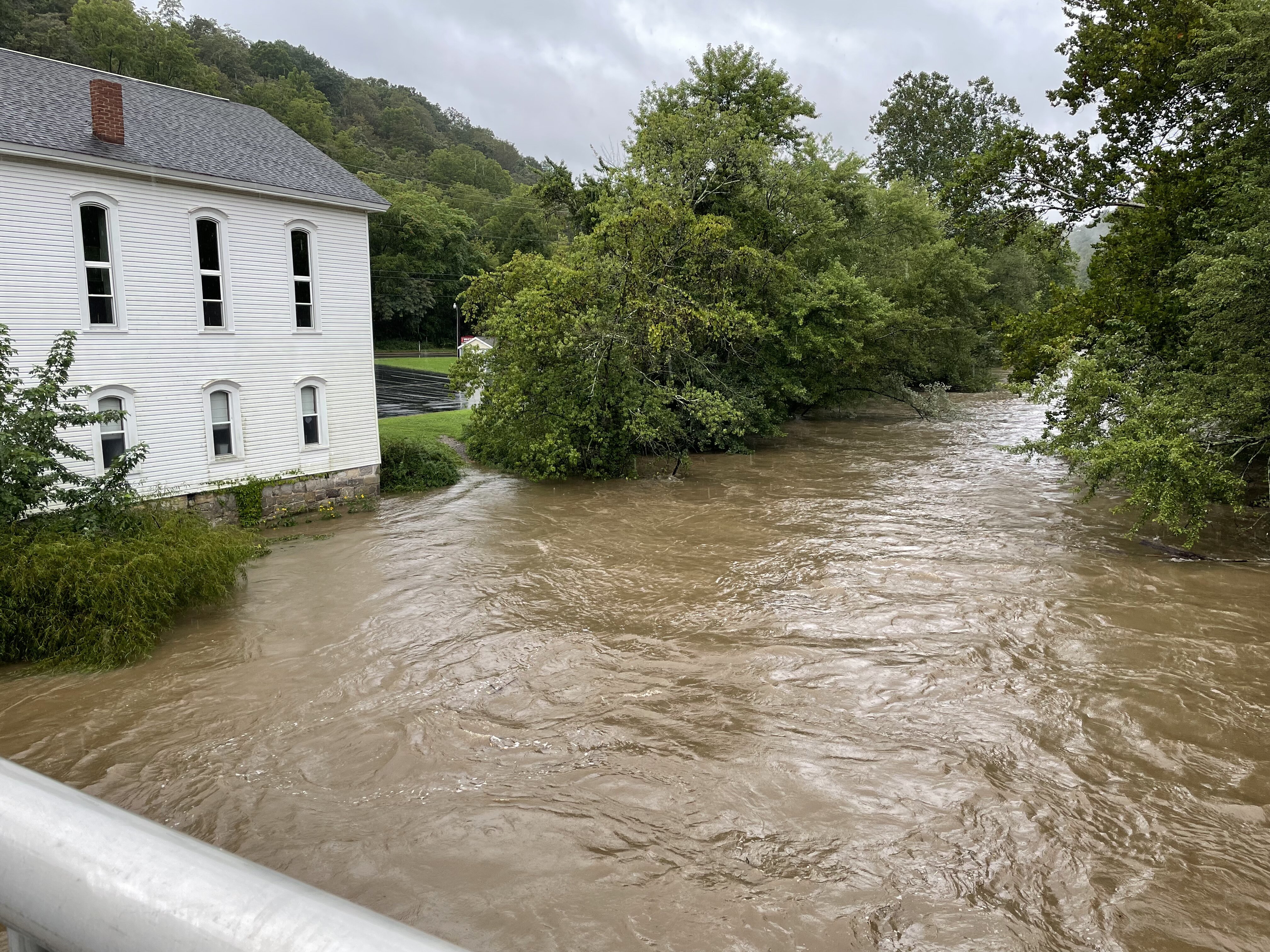
Couple other pics of the river from a bit further up the road in Spruce Creek, PA.

-
3
-
-
Rain has ended back this way. Got a few pics but flooding on this end of the county was not as significant as the southern half of the county, roughly from the 22 corridor south.
This video (if it works), is the Little Juniata right by the gauge station ( LIttle Juniata @ Spruce Creek). This is just shy of flood stage at the time. It has since cracked into flood stage so there is likely some water on the road at that spot now.
-
1
-
-
Will be heading out to get some footage/pics as far as I can still safely make it somewhere.
-
5
-
-
Per scanner app they’re getting ready to close off US 22 between Hollidaysburg and Water Street (likely near the Canoe Creek/Williamsburg) area with the river already nearly about to come over it. Frankstown Branch of the Juniata now forecast to crest only a couple feet from it’s Hurricane Ivan record crest.
-
Been moderate to heavy rain all morning and since the later overnight hours here. Bit of a breeze too.
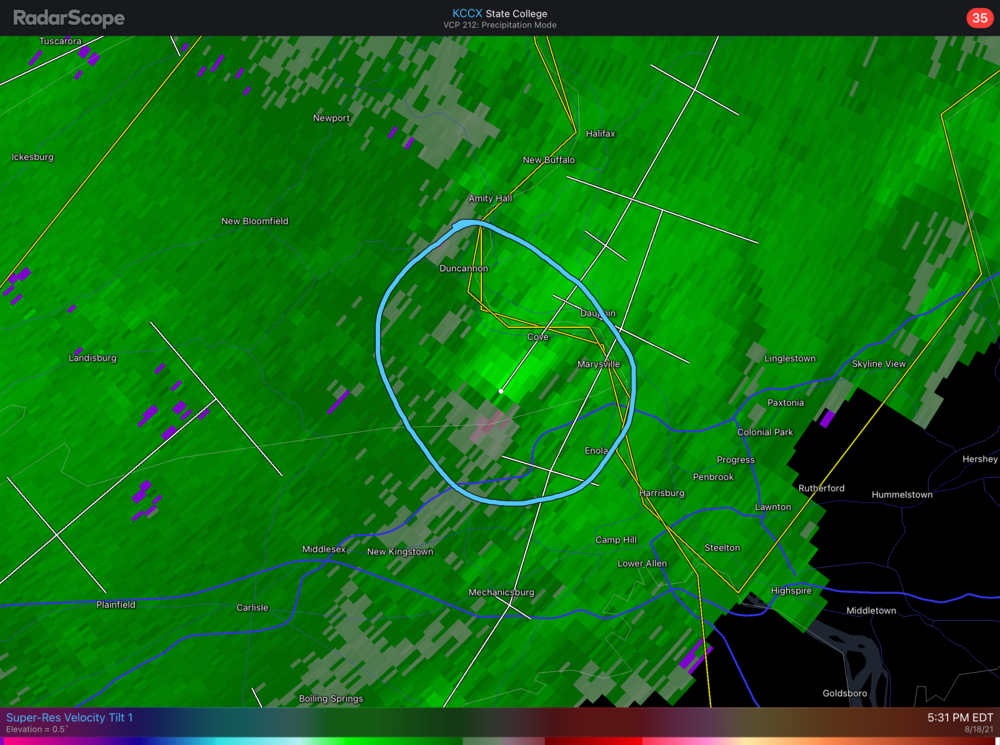
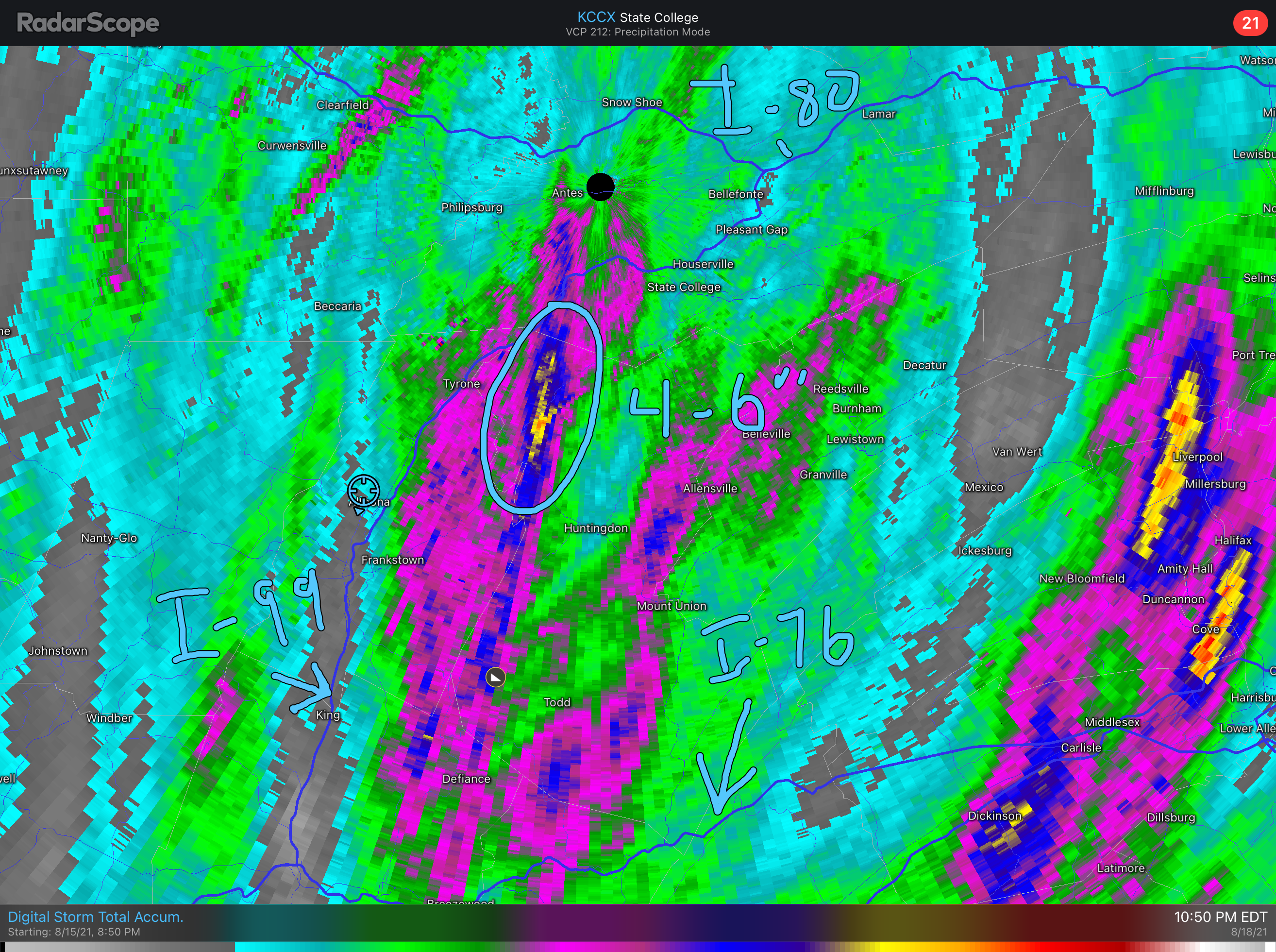
The next several hours are when the worst of this in terms of rainfall rates traverses central and the LSV. Circled on the image is the area of enhanced heavy rainfall that has shown up well on all the model guidance the last few days. Roughly south of the dashed line I drew is generally where I think the heaviest rain will reside. Very concerned about my area and especially along the turnpike where parts of Bedford/Fulton/Franklin saw heavy rain last night before this main precip shield. I’d be willing to bet that double digit amounts have the best chance of showing up in that area.

-
1
-
-
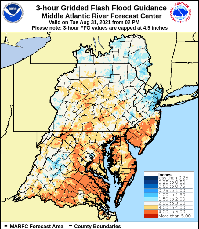
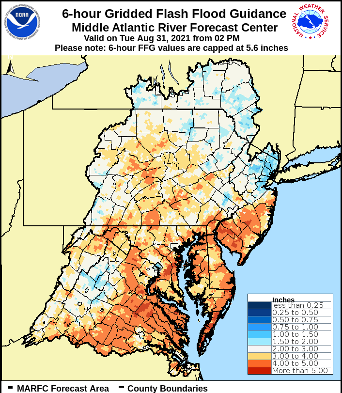
Here’s the flash flood guidance (1, 3, and 6hr) from MARFC for reference.
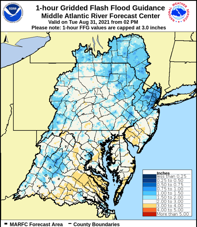

Also headwater flood guidance for CTP’s region
-
1
-
-
23 minutes ago, Eskimo Joe said:
High risk of flooding per WPC for you all tomorrow. I am insanely jealous of what's about to unfold across S Central PA tomorrow. Going to be one for the record books for some. Already a good PRE ongoing across Somerset, Bedford, Fulton, and Franklin counties with even some weak spin. Seriously enjoy this, going to be a storm worth studying once all is said and done.
Definitely mixed feelings as I’m def excited for the event from a meteorological standpoint but on the other hand not too enthused with the likely major flooding impacts around here (and everywhere else) if we in fact see those 4-7”+ amounts back here in the more mountainous ridge and valley region.
-
1
-
-
15 minutes ago, Bubbler86 said:
Flood rescue in NO again. Levees failing again? Crazy if some of these reports are true.
I know earlier Cantore was wondering aloud on his live report earlier if the entire city being out took out some/most of the pumps that’s take care of getting storm water out. It’s been reported that a transmission tower failed taking a line down over the Mississippi. Either way, I’m sure there’s portions of the city that are having problems with flooding just from the excessive rainfall.
As bad as things are, the center coming up just west of New Orleans instead of taking a Katrina like track just east should be keeping major surge off of the Ponchartrain levees, which was where a lot of the 2005 failures were (obviously much improved now) Instead, the major surge is on the NW corner of Lake Ponchartrain with the northern and eastern eyewall going up just west of most of the metro area. At this point of the storm, the fetch is southerly or away from the Ponchartrain shoreline in New Orleans.
-
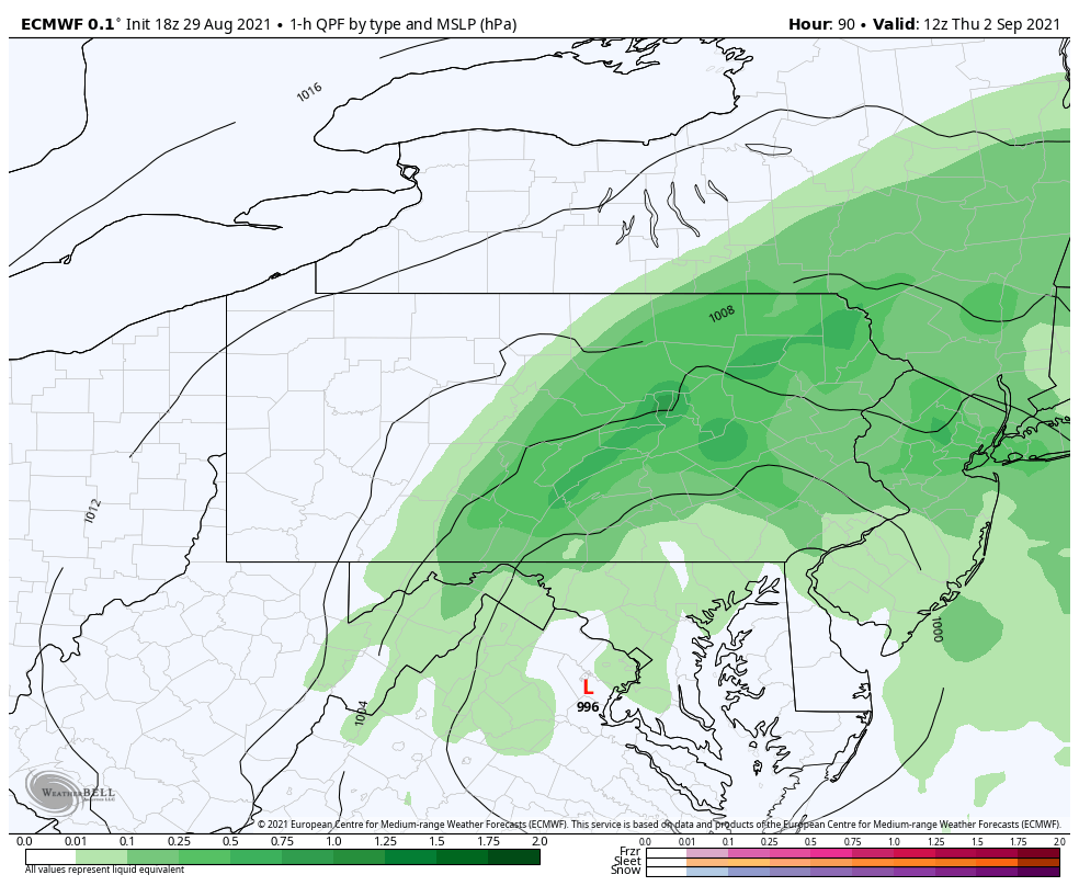
12 minutes ago, Voyager said:
I don't have off hour Euro access. What's the qpf look like for central and eastern PA?
Here’s the Hr 90 frame, which I chose 1 hr QPF to show roughly where the precip shield still was.

And here is the 48 hr QPF total to that point, most of this falls in 24hr back where these extreme totals are in the central counties.
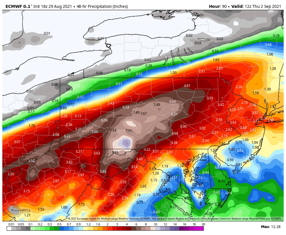
That’s definitely the most extreme of the model suite I’ve seen for sure, and I hope it is being a bit too over amped.
-
I was just looking at the 18z Euro and its QPF output, which wasn’t even done through hr 90. This area back here would be in big trouble if we ended up with something like that, wow.
While the Sus Valley had Lee more recently as the last major tropical flooding event, gotta go back to 2004 with the one-two of Frances and Ivan in a one week span back in this part of central PA for historic tropical related flooding. The 7.55” and counting the 18z Euro put out at KAOO would probably amount to something worse than even that if that actually came to fruition.
-
1
-
-
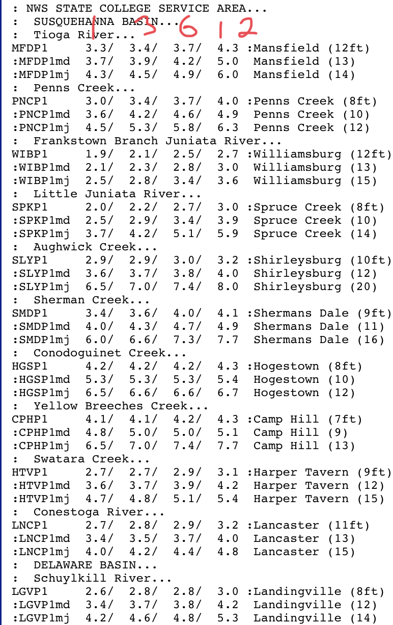
Ida definitely represents a pretty significant flooding threat for the area, especially for the southern half of PA. Talking big picture of our region as a whole, we’ve been fairly wet as of late.. with the remnants of Fred being the big recent rain event. We’re not saturated, but flash flood and headwater guidance are such that a 3-6”+ type event would likely send tributaries to moderate or major flood categories.
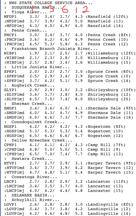
For example, here’s today’s headwater guidance in CTP region.
So this shows the estimated rainfall to reach each category (minor, moderate, major) at 1hr, 3hr, 6hr, and 12hr timeframes. The Swatara at Harper Tavern for example would need about 5” in 12hrs to reach major flood stage.. definitely doable with the numbers the models are cranking out.
Big key as always, track of what will be probably either a depression or remnant low once it gets to us. Track of the low just underneath PA in this setup puts at least some part of our region into where what’s left of the core tracks through, and that’s where the business end of this potential major rainfall and flooding will be at. Given how organized this hurricane was (and still is), it’s likely to maintain a notable core remnant. That is where within the overall event you could see say 2-4”+ in under 6hrs, which would deal major issues on small and some bigger tributaries. As far as the main stem Susquehanna, its going to depend on the location of the swath of excessive rainfall. If it targets southern half of PA like the Euro does, it doesn’t quite get the whole basin and might not deal much more than minor flooding on the lower end of the Susquehanna main stem. If it tracks more like the GFS seems to have today, which catches more of northern PA and all the West Branch and Juniata basins.. response on the main stem would likely be more significant.
-
1
-
-
Didn’t have too many major issues locally today, despite having some pretty significant rain totals along and east of I-99. Doppler estimates right over my house are in the 1.5” or so range, which seems about right as I had the first band that triggered the early flash flood warning just to my east only briefly. CTP noted in their disco earlier that KAOO saw over 2” in 40 minutes between that 12-1pm hour.

Did some driving in the large area of 3-4” (purple and blue) this afternoon as well as in what ended up being the eventual local bullseye of 4-6” in NW Huntingdon County. Surprisingly I didn’t come across any major flooding issues or impassable roads, just a lot of washouts and decent run off. It hasn’t been overly dry around here but it also hasn’t been wet either, thus I think the ground and vegetation was able to mitigate what can be a pretty major flash flood event with precip numbers like that in a 6-12 hr span. Both Frankstown and Little Juniata branches of the main stem Juniata River easily stayed below flood stage despite the gauge stations being right in that 3-4”+ area.
-
2 hours ago, Newman said:
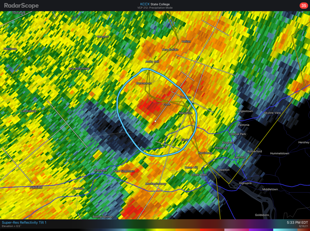
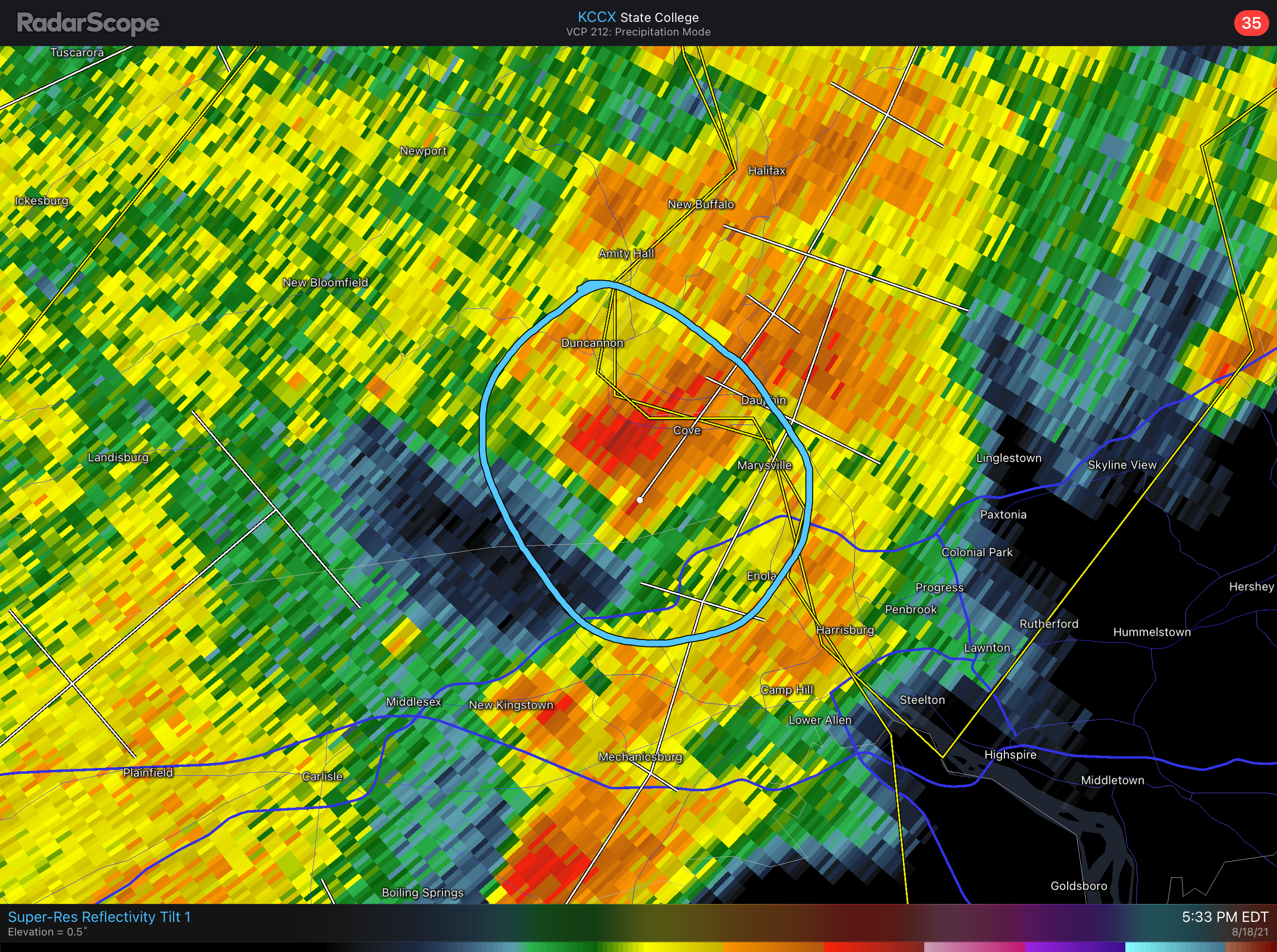
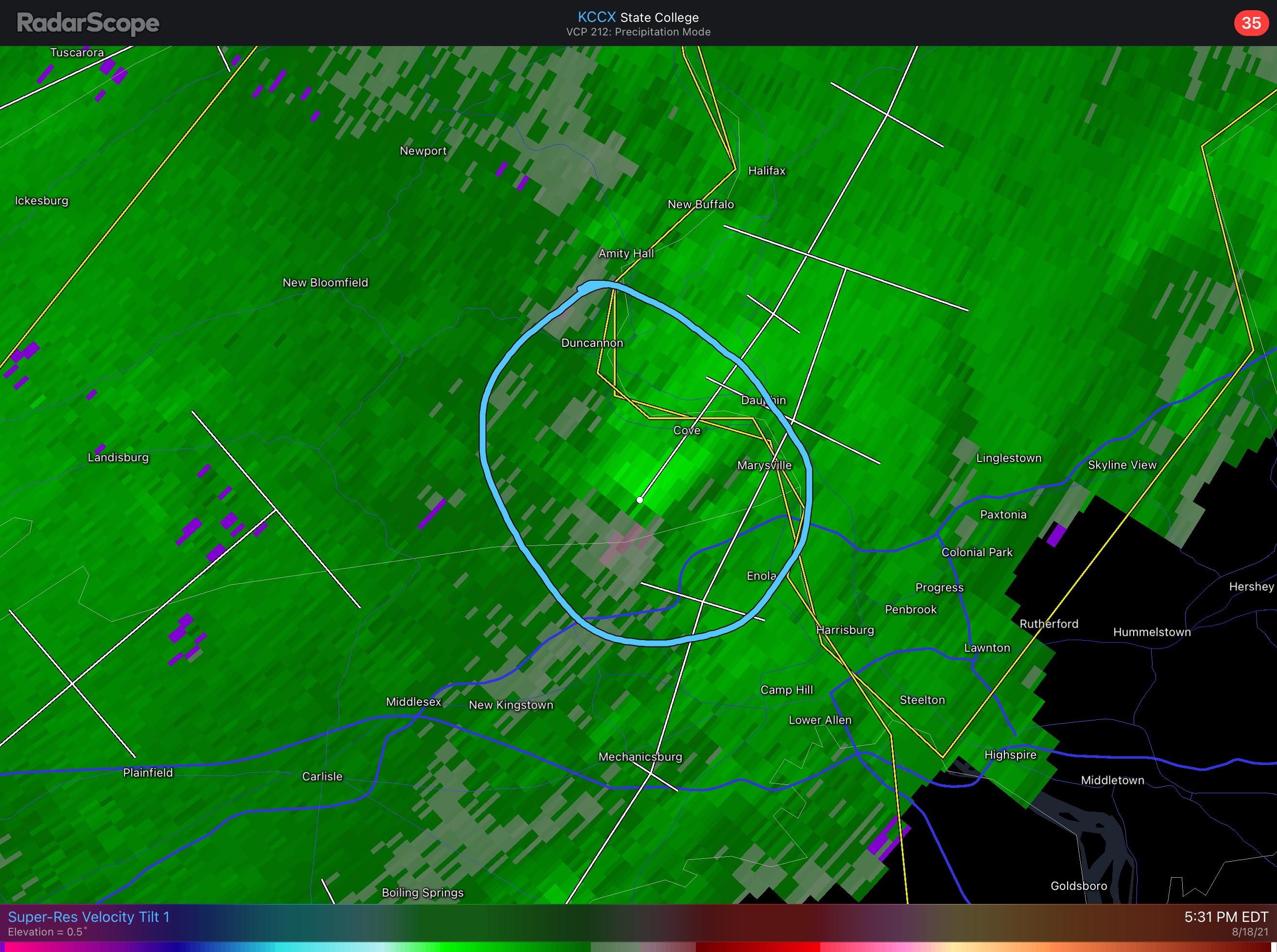
2230z UNK 4 E HALIFAX DAUPHIN PA MULTIPLE TREES DOWN. FUNNEL CLOUD REPORTED.
That might have been the one storm with the couplet I made a post about earlier back on Page 176 when it was south of Halifax at the time.
-
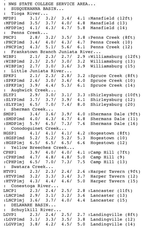
The storm just west of Marysville is showing a half decent couplet. There are several areas in these line segments in the LSV that have these couplets. A lot of times in these tropical system situations the couplets present more as a velocity max rather than really seeing a true couplet (with notable opposing velocity) A quick spin up can’t be ruled out with them but the bigger possibility would be potential severe gusts or at least non severe “tropical storm force” gusts.
-
1 hour ago, canderson said:

I just had one of the bands come through a little bit ago, and it was very intense. That band is now just east of town and it is likely to trigger flash flood warnings (surprised it hasn’t already) as the motion is starting to align with it’s orientation. In other words, basically training south to north over the same general corridor with very slow overall propagation towards the east/northeast. It’s also trying to fill back in here some.
-
1
-
-
I should be able to make some obs and discussion as this unfolds tonight and tomorrow. Since I literally sat on the edge of the precip with Isaias pretty close to this time last summer, it’s been awhile since I’ve had a decent tropical remnant event come right through here.
-
2
-
5
-


Central PA - Fall 2021
in Upstate New York/Pennsylvania
Posted
Haha I was gonna post that CNN already has a hype article on this possibility but you beat me to it.
This was the timeframe that the one GFS run a few days ago had a monster with like 20-30”+ of snow over a large part of PA. The Euro has also occasionally had wound up coastal runs that had interior PA snow. It’s definitely a timeframe with potential with what looks to be a pretty significant amplification of the pattern and favorable trending of pretty much all the major teleconnections going into next week (NAO/AO going negative and nice Greenland block, EPO/PNA going positive). Big takeaway regardless of the eventual evolution of the features that may or may not deliver a coastal is the Thanksgiving holiday and the couple days either side look like they could be pretty cold. Some of you guys might even have to turn the AC off haha.
I’m not sure if a straight up winter pattern sticks quite yet. Kinda looking more into the start of December or so for the possibility of that. The early stratwarm events and Nina ENSO state are lending support to what has seemed to be a general theme of a quick start and cold December in most prognosticators winter forecasts. Lining up the teleconnections and keeping them in the direction they appear to be heading next week will def go a long way to giving the east a cold pattern right off the bat kicking off meteorological winter. The return of significant blocking in the NAO/AO realm really saved us last winter against a pattern on the Pac/western US side that was rarely favorable. So one thing I’m looking for as a key to success of consistent cold winter weather this winter is having the favorable Pacific/Western US pattern as I wouldn’t trust depending on seeing the kind of long lasting anomalous -NAO we saw last year.