

MAG5035
-
Posts
5,718 -
Joined
-
Last visited
Content Type
Profiles
Blogs
Forums
American Weather
Media Demo
Store
Gallery
Posts posted by MAG5035
-
-
Just now, 2001kx said:
it just keeps getting heavier...up to 13" as of 9:25
I see you had to switch to a bigger ruler haha.
-
 2
2
-
-
47 minutes ago, pasnownut said:
Thanks bud. Wasn’t sure. I’d take .8” sleet with a couple inches on top.
You think you’ll get to 18”? From mesos I think you’ll be right close.Next couple hours are crucial but my chances for getting that high are slipping away the longer that band stays arced to my NW and north. It seems to be setting up over 2001kx over to just NW of IPT. @2001kx has to be getting crushed. This is the band that's going to see the excessive totals and it's setting more NW than any guidance had it earlier today.
Up to 8" with moderate rates. Snowing decent but I probably lost my outside chance at 20".
-
 1
1
-
-
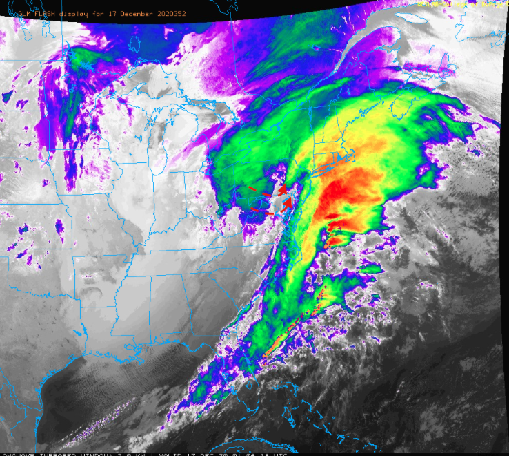
You can see the dry slot on the IR, if you put it in motion you can see the comma head shifting towards the Sus Valley.
-
1 hour ago, Blizzard of 93 said:
How is the surface low track looking in real time?
How soon could the LSV go back to snow as the coastal low further develops & heads northeast?Mesoanalysis has the low roughly on the southern tip of the Delmarva currently. So track doesn't look to end up as far NW as some models had it but the models like the Euro and especially NAM got the stronger warm nose aloft correct. I was def thinking mix in southern York/Lancaster but didn't think it'd get as far north as it did. That tremendous 850mb fetch likely had a big hand in that.
I'd say things will probably get changed over once heavier precip starts shifting back into the Sus Valley (and also comes up from the SW by looks of the LWX radar). Likely within the next couple hours.
-
1
-
-
4 minutes ago, 2001kx said:
Up to 10" now
That's a nice band your set up in right now, it does seem these deform bands are setting even more NW than some of the more NW guidance had them.
-
1
-
-
7 minutes ago, pasnownut said:
Wonder how well it does with factoring sleet in?
WeatherBell doesn't include sleet in it's snow map like TT does. There's a separate accumulation map for sleet (using a 3:1) map.
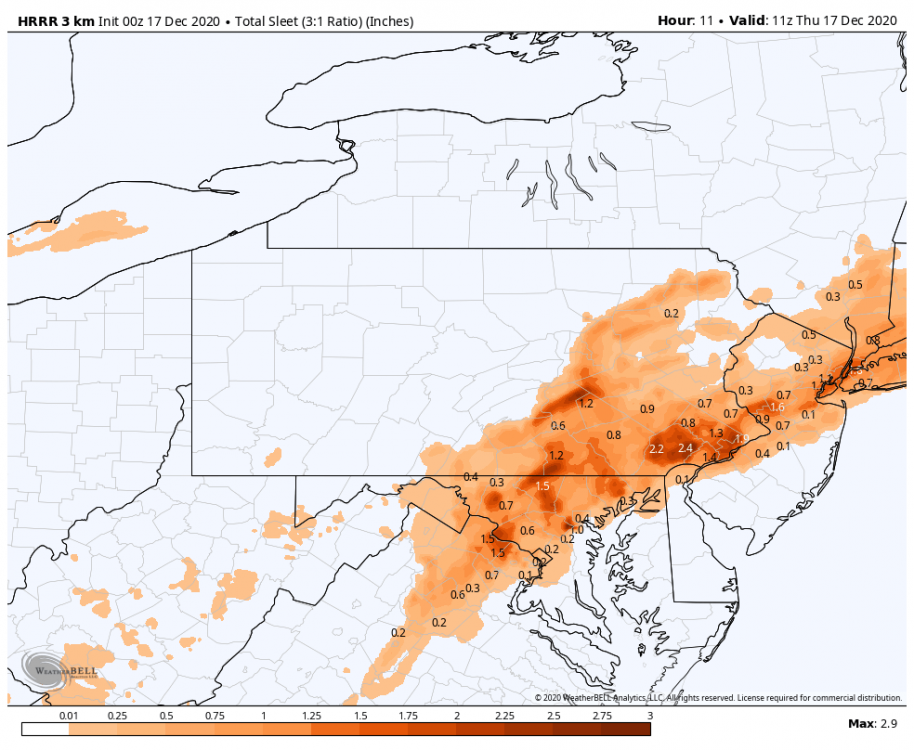
Which brings the question, does anyone have any noteworthy sleet accumulations to report? Typically I'll measure and clear when a transition occurs and measure the sleet separately.
-
7.6" and moderate snow. Waiting for that deform band to shift over just a little bit more.
-
1
-
-
7.0" Moderate snow.
That band associated with the thundersnow over Mt Davis (Somerset County) is lurking. I did see the GLM flash product on the COD satellite page pick up on about two or three strikes back about an hour ago. The extra instability likely aided by the SE flow over the one ridge line in that region.
-
8 minutes ago, canderson said:
Tom Russell (CBS21) says dry air is gonna hurt everyone in the LSV.
13 minutes ago, canderson said:Now hearing sleet on the windows. Not ideal in Harrisburg.
So the pingers did make it to H-burg. I'm pretty surprised the mix line got up that far, so looks like the NAM et al ended up being more correct thermally aloft.
In terms of the dry air post I mean yea it does appear the slot is going to get into the LSV, although judging by LWX radar trends its more of a slot of lighter rates than an actual dry slot. Since the columns already busted, the lighter rates will probably ensure some mixing continues until the heavier bands start shifting back east/northeast later tonight and heavier rates and dynamics likely turn things back to snow. The pivot isn't completely obvious yet but it does appear like it's showing some signs of starting, so watch radar trends on CCX radar.
-
M6.2". Heavy snow with a pretty stiff breeze. 0.8" last hour
-
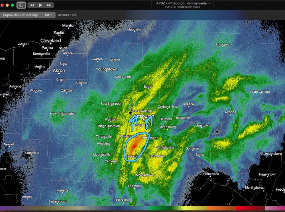
1 minute ago, KPITSnow said:
Can confirm that band in PIttsburgh is ripping.
That stuff about to come up into town from the south looks nuts. Checked the CC product to make sure that wasn't a mix lol (50dbz!)
-
10 minutes ago, Cambria County Wx said:
For those in the JST-AOO-UNV corridor, really nice band out by Pittsburgh , watching the dry slot down by Meyersdale(Somerset County). That band looks to be slowly moving east towards the region.
Yea we might have some lower rates or at least more varying rates during about the 6pm hour or so. The stuff building on Pittsburgh radar should pivot over and I think the real height of this thing could be roughly 0-3z (7-10pm) with the max rates of the storm.
-
Moderate to heavy snow continues. Breeze has kicked up a bit. M5.4" with 1.4" in the last hour.
-
-
At 4.0". Rates really picked up within last 20-30min.. it's really going to start piling up. Very heavy snow and visibility under 1/8th. This stuff is straight powder snow too.
-
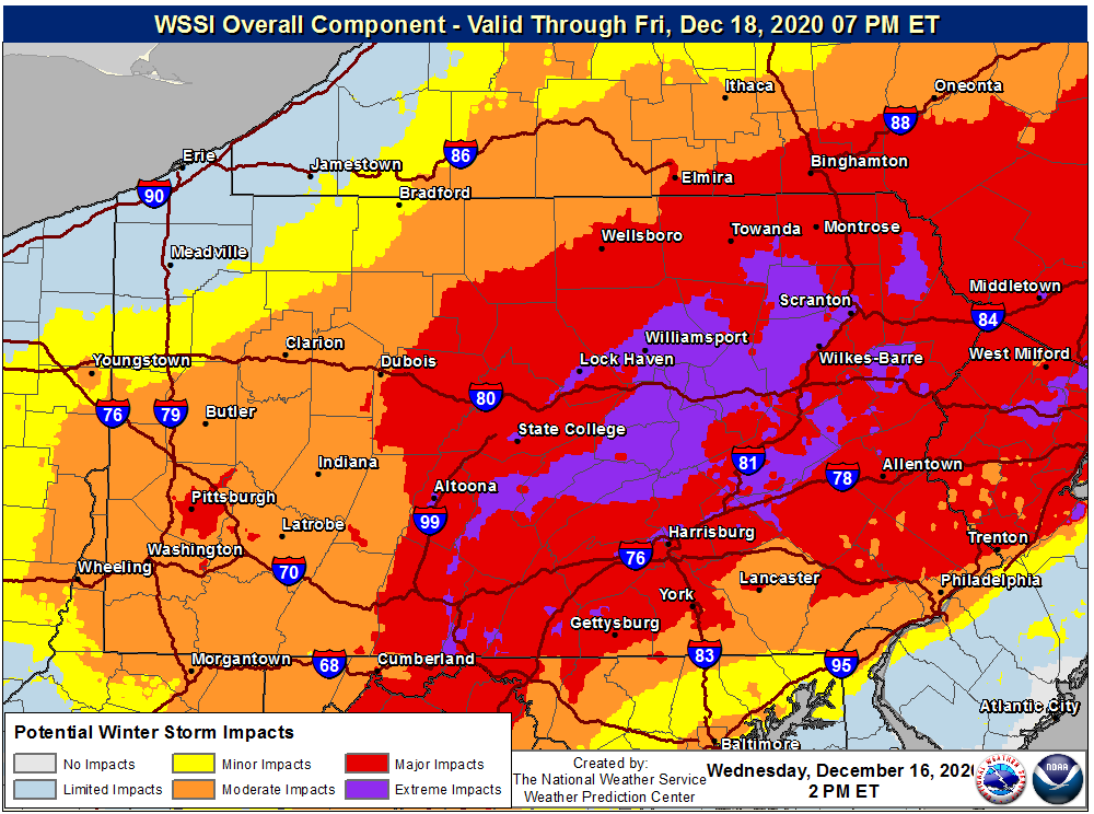
Quote
.NEAR TERM /UNTIL 6 AM THURSDAY MORNING/...
Major winter storm in progress throughout central PA with
snow reported at all central PA METAR stations since 18z with
+SN along and south of I-80. The storm is on track with previous
predictions and may challenge December snowfall records before
all is done on Thursday morning. Widespread snow accumulations
of 1-2 feet are expected along and east of I99, with snow rates
as high as 2-4 inches per hour this evening through late tonight.
Winter Storm Severity Index reaches the Extreme category for
many valley locations from the Central Mountains to the Pocono
Plateau, including State College proper.

Main changes since previous update were to decrease snow totals
due to mixing with sleet over far Lower Susq (southern York and
Lancaster Counties), increase amounts slightly from Central
Mountains to the Endless Mountains, where confidence has
increased in 20"+ amounts, with consensus there for localized 2
foot+ before the storm winds down early Thursday morning.

Today`s focus was on evaluating the timing and location of
heaviest snowbands, where where some 2-4" per hour rates are
possible from late this afternoon through late this evening
central and east. Guidance has shifted ever so slightly farther
west with the higher intensity frontogenetical/CSI banding,
increasing the likelihood for widespread foot plus amounts and
much of the area in the 18-24" range for this storm. HRRR has
spot amounts exceeding 30", but confidence in that outlier solution
is on the lower side. However, if a situation could produce
those amounts and we could achieve 15:1 snow ratios from the
anticipated QPF, this cannot be ruled out. Given the height of
the DGZ, slightly less than ideal fluff factor is present and
suggests snow ratios in the 12:1 inch range. Peak period of
CSI-banded heavy snow comes mid to late evening with the
potential for thunder snow as the nose of a strong, 50-60 kt
easterly 850 mb jet and 130 kt upper jet focuses hefty uvvel and
slantwise instability near and just to the NW of the I-81
corridor.

Cold Conveyor belt/FGEN moderate snows with near 1 inch per hour
snowfall rates should linger until around, or shortly after
daybreak from KUNV to KIPT and points NE, leading to the axis of
heaviest snow near or just to the SE of that axis with some
areas seeing 18-20 inches for high-end storm total amounts.

The storm will be relatively quick moving, with most places
seeing precip for 18-24 hours. Nonetheless, with cold
temperatures in place, good SLRs, and very strong frontogenesis,
this should end up being the most significant snowstorm for
most of the area since November 2018... and for some areas,
perhaps one of the heaviest snow events in the past 5+ years. It
also may rival some of the record 1-day and 2-day December snow
totals. For reference, the December 2-day record snowfall at
Harrisburg is 13.9 inches, set in 1961.
-
37 minutes ago, Itstrainingtime said:
What's the biggest storm on record at IPT?
Per CTP discussion, it had to have been close but apparently March '93 must not have went down as a 24"+ in IPT. This storm has a chance to break all of that.
.CLIMATE...
The last time there was 12+" of snow over a two day period (as
many storms will cross from one date into another):

State College:  6-7 Feb 2010 = 14.0"
Harrisburg:   20-21 Mar 2018 = 14.2"
Williamsport: 14-15 Mar 2017 = 18.4"

Last time there was an 24+" storm (not sayin`, just sayin`):

State College:  3-4 Mar 1994 = 27.7"
Harrisburg:   22-23 Jan 2016 = 30.2"
Williamsport: 12-13 Jan 1964 = 24.1" (the only two-foot storm
for Williamsport)

Highest two-day total:
State College: 29-30 Mar 1942 = 30.5"
Harrisburg:    22-23 Jan 2016 = 30.2" (that one, again)
Williamsport:  12-13 Jan 1964 = 24.1" (that one, again)

Higest two-day total in December:
Harrisburg: 24-25 Dec 1961 = 13.9"
Williamsport: 25-26 Dec 1969 = 17.2"

Highest one-day total in December:
Harrisburg: 23 Dec 1963 = 10.1"
Williamsport: 26 Dec 1969 = 14.7"
State College (7am-7am): 11 Dec 1992 = 12.5"
-
1
-
 1
1
-
-
4 minutes ago, 2001kx said:
Think I have a shot at 12" back here?
Definitely, the radar seems set up real nice right now. You may miss the most intense bands but I think you should get to at least 12" without too much drama.
-
2.9" with moderate-heavy snow. Visibility ~1/4mi. 1" in the last hour. That rate has been about the same since a bit before 1pm.
-
2
-
-
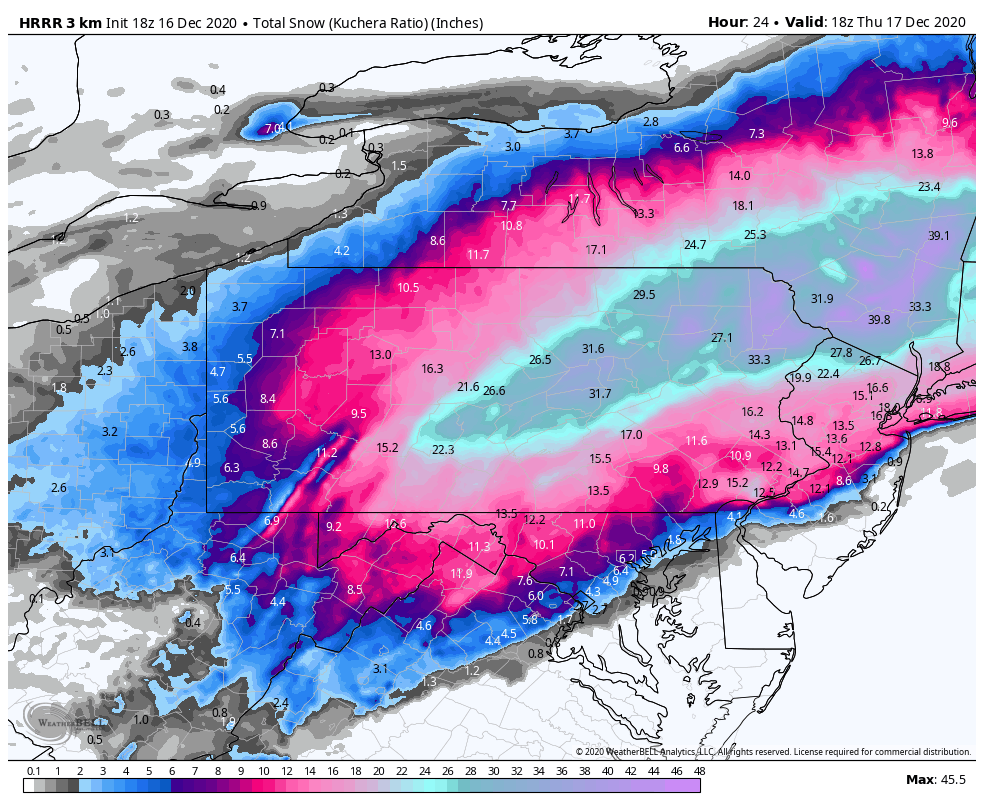
Wow on the 18z HRRR. And these Kuchera totals aren't doing anything mind blowing ratio wise. Did some calculating and KAOO and UNV get to their ~2ft amounts via 14-15:1 ratios. Selinsgrove (SEG) and IPT get to their nearly 32" totals via a 13-14:1 average. This is doable if the QPF ends up that high in the deform bands.

-
2
-
-
Passing the 1" mark here, moderate rates and 26ºF.
-
1
-
-
Looks like the more steady stuff has arrived here by looks of the radar. Moderate rate currently.
-
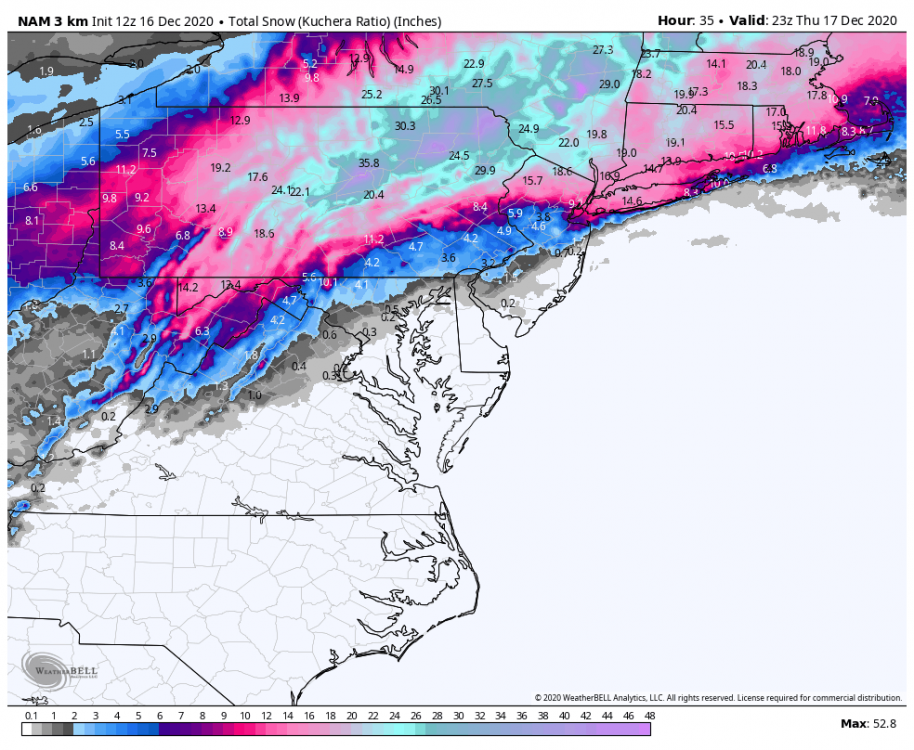
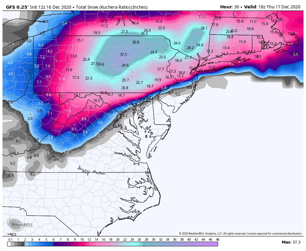
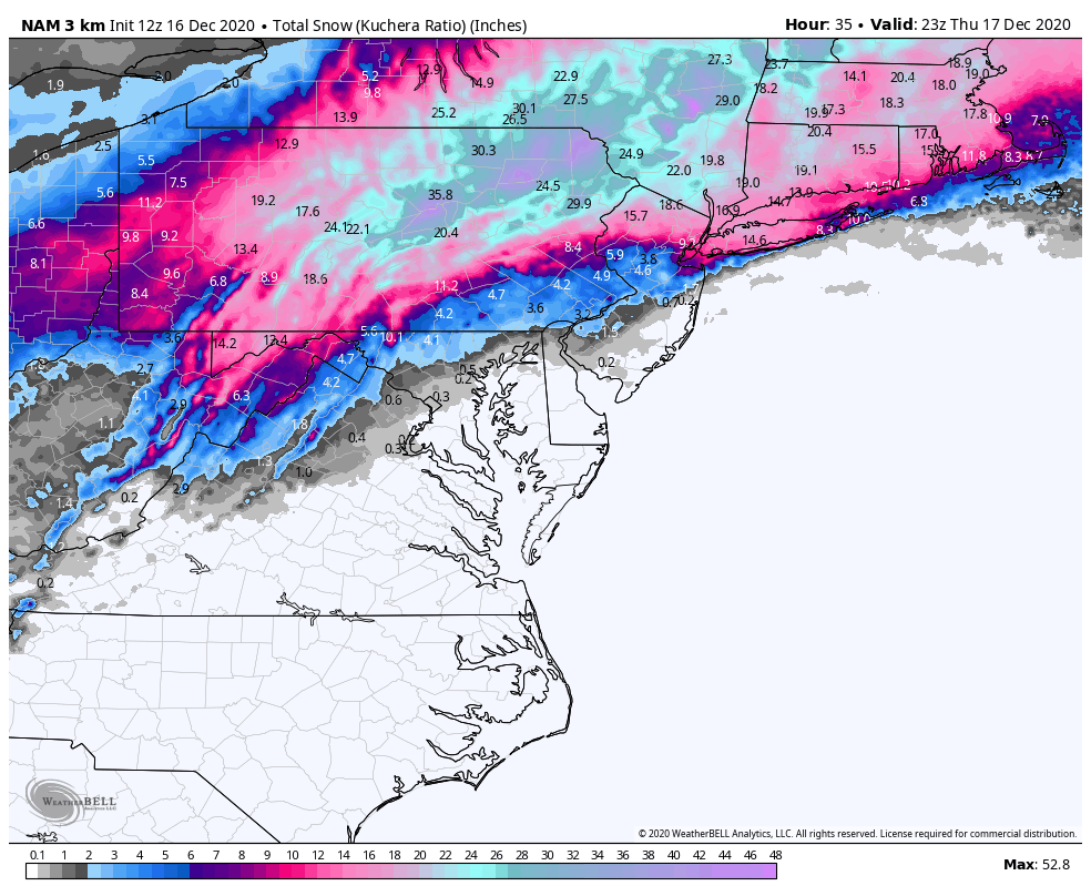
Wow, this might have been the snowiest GFS run of them all right at game time. Both that and the 3k NAM have 3' at IPT (via Kuchera). Huge difference in the York/LNS realm though. That's going to be something to watch today which model wins with the thermals. Heck the 3k NAM got sleet all the way to KAOO on a huge surge of >0ºC 850mb temps, that's probably not going to happen. York and Lancaster probably aren't quite going to get to 20+ either as there should be some mixing. Given already solid establishment of cold air at 925mb and below via the Canadian high, I still feel most mixing is going to be in the form of sleet north of the mason-dixon.

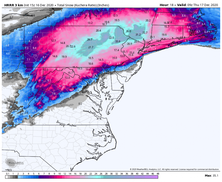
Here's the latest HRRR, which probably represents accums in the LSV a bit better currently with limited erosion of the accumulations in far southern York and Lancaster . Still snowing at 18hr in pretty much the whole eastern half of PA.
-
1
-
-
Already a nice burst of moderate-heavy snow with this first band, accumulating on all surfaces.
-
1
-


December 16 2020 CTP Snowstorm Disco and Obs
in Upstate New York/Pennsylvania
Posted
Probably the next hour at least (edit: I'm talking just about the heavy band, not the rest of the event lol). I'm watching to see what that weak spot in returns does down in Somerset County and if we keep building some banding. Back to heavy snow here but probably not as heavy as there.