

MAG5035
-
Posts
5,718 -
Joined
-
Last visited
Content Type
Profiles
Blogs
Forums
American Weather
Media Demo
Store
Gallery
Posts posted by MAG5035
-
-
Initial bout of light precip started as a light sleet here and it’s around 30. It’s still working out the dry air and hasn’t really done much yet. I wouldn’t sweat things starting out as sleet or surface temps a little close to freezing. The issue will be aloft and as the precip starts it may start as sleet as the column cools from wet bulbing
-
49 minutes ago, heavy_wx said:
This will certainly be a very dynamic event. The image above shows a pretty good setup for heavy precipitation in central PA with the area between the right entrance region of the northern jet streak and the exit region of the southern jet streak (add in some curvature on the latter and that increases the favorable lift for our area). You can see below that this circulation is also tied to mid-/low-level frontogensis; this region of enhanced lift moves northward Thursday afternoon and will be associated with the heaviest precipitation.
A forecast profile from this time shows the maximum lift (i.e., negative omega) around 600 mb at UNV. It happens to also coincide with the dendritic growth zone so that, coupled with the near-freezing temperatures between 850-750 mb should lead to very large, wet aggregates around this time.
The duration of snow vs IP or ZR is of course predicated on how resilient the cold air will be at low levels. There is noticeable 500-mb confluence over northern New England currently, helping to promote anticyclogenesis and associated cold ageostrophic flow into our region. However, the surface high moves eastward and weakens late Thursday into Friday, allowing for temperatures to warm above freezing the in the 800-700 mb region. Things do cool off again for potentially another round of moderate snow as the energy from the secondary low moves east through the region Friday morning (probably more favorable for areas in eastern PA).
It's definitely a cold airmass for this time of year, but I have been burned before up here with mixing occurring earlier than expected. Will be a fun one to watch!
I can certainly understand CTPs perspective of having to temper forecast snow amounts with regards to a very uncertain evolution on mixed precip. For the UNV region and surrounding areas I see this as more of snow/sleet and how much sleet mixes in scenario as the central counties should easily remain below 0c at 925mb to the surface.
Even though the high does eventually start moving away and weaken some as the storm advances, it’s still a pretty cold setup especially given it’s only mid-November. An intense push of precip with the initial precip shield with the aforementioned strong lift might render that a moot point if the region (including a big part of the LSV) gets crushed with several hours of heavy snowfall right off the bat. That seems to be where the near term modeling like the HRRR is going. I personally think it’s going to be more of a 5-8” type deal back in this area but I am certainly aware that sneaky warm air in that 750-850 region could sleet that top end away quickly. If things did end up mostly all snow and we managed to score some off that deform as the coastal takes over this has the potential to be a double digit snowstorm as the Euro/Euro EPS/Canadian/RGEM have been alluding to.
I’m excited either way, today was one of those days you could “feel” something wintry is on the way.
-
16 minutes ago, Wmsptwx said:
Where's GEM lining up?
Today’s 12z looked pretty cold, lot of snow on the p-type products. 6+ for most everyone with less in SE PA towards philly. Also has a stripe of a foot plus right up the middle of PA (bit thinner than Euros)
-
Euro is a big hit. Put simply the snowmap (10:1) has virtually the entire state in 6”+ with roughly the central third of the state 12”+
-
 2
2
-
-
6 minutes ago, Voyager said:
12z NAM has a MASSIVE dryslot for southeastern PA @ hour 36...
Dry slotting was mentioned in this morning’s CTP disco as a potential limiter along with the uncertainty in p-types. It’s def something to keep an eye on especially in eastern PA given the surface running tightly up the coastline. Storm evolution actually progged as a more Miller B type evolution.. thus the initial front running shot of moderate-hvy precip and potential slot as the lows transfer.
There will then be a deform band that forms as the coastal low takes over and the aforementioned tight track up the coastline would favor the deform further back in the central counties. The damage could already be done up front though in the Sus valley as we will have supported cold air in place and I think we will have a robust front end that should wet bulb into a primarily frozen first part of the storm. If the coastal low track ends up being somewhat off the coast, then that deform might focus more towards the Sus Valley.
So ultimately I think our whole region is pretty well locked into our first sizeable winter event of the season incoming (at least advisory worthy). The degree of mixing plus eventual storm evolution and positioning of the deform band as the coastal takes over will determine if and where we see a much more significant impact. The potential is definitely there for a corridor in our region to get ripped with a big snowstorm. Some similarities to Nov 14-15, 1995... State College had 15” from that storm. I think the difference at least looking at the reanalysis maps is that one looked to be more of a pure coastal storm and perhaps was a bit colder.
-
2
-
-
I just got back from being away the last several days last night and my laptop has also been out of commission lately so that’s why i’ve seemed fairly quiet but I’ve been watching this threat materialize on the models and I like what I see.
The track is a good one for C-PA snows... and given the progged high overhead this storm will be attacking and the storm’s gulf origins, this could be quite a robust winter storm. I think wintry precip for most or all of us in here is a pretty good certainty but how much mixing occurs and where is what will need to be sorted out the next day or so.
As it looks right now, I’m pretty confident of a warning level snow threat in the Laurel’s and north central elevations. The adjacent central mountains and AOO-UNV-IPT corridor could go either way but it would probably be a more advisory type elevational snowfall with some mixing. I could also see warning totals in this region if this ends up on the colder side.. but likely for folks at higher elevation. The Sus Valley also looks to see a slushy 1–2 with a lot of mixing attm. What I would want to keep an eye on is the initial precip shield. A front running shield of moderate to heavy precip with the high in place over NE and wet bulbing would likely make for a front end thump for even the Sus Valley. And I’m willing to bet colder given the high position and storm track. Whatever happens it’s always nice to see threats on the table right off the bat.
-
2
-
-
5 hours ago, Atomixwx said:
I have a very hard time believing that a nor'easter is going to develop in marginally cold air in October and not drop a ****load of concrete on folks 100 or so miles west of the centre. I just keep thinking it's October 29, 2011 all over again.
We'll have to see how the models address temps aloft the next couple days as we get closer to the timeframe of this potential storm. Right now they seem to have moderated a bit in the last several runs, being close but not there for a widespread snowfall. The placement of the surface and 850mb lows are very good, but just not enough cold available. I'm still pretty confident on this ending up at least a high elevation snow threat in the Laurels/northern mountains but not sure about the central counties and LSV. It is kinda similar to the 2011 event but minus the tropical source via Hurricane Willas eventual remnants. This will probably be a wetter storm but unfortunately a warmer one than that one. We had a more impressive cold air mass in place for 2011, which made that storm have a feel of a storm a month or so later than it occurred. It's hard to get that kind of a widespread storm this early. Storm isn't really tremendously deep on models right now either (including the crazy Canadian). I think we'd need a more dynamic low (in the 980s or more) to maybe promote cooling aloft via that.
Also, if we do get the Oct 2011 repeat...I sure wouldn't want the winter 11/12 repeat to go with it.
-
Modeling has been hinting at a timeframe (Oct 28-30ish) where an amplification in the pattern could yield the first legit coastal threat of the fall/winter. Todays 12z Euro showed a nice coastal right on the Delmarva next Sat night/Sun morning. The GFS has the same southern wave but late northern stream interaction resulting in a miss, but the feature is obvious and on a pretty familiar positioning vs other guidance for GFS standards. The Canadian went off the deep end with a Delmarva 967mb bomb curling into eastern PA at 975mb. Probably quite overzealous there, but ensemble guidance lends decent support (considering D6-7 range) for some kind of a coastal system.
Of note with this potential would be a charged southern stream given the East Pac hurricane (Willa) being progged to be drawn up through Mexico into the Gulf. It could be a very robust coastal storm if we got the well timed phase. The European taken at face value with the finer details was probably only a couple degrees off of being a paste bomb in at least a sizeable portion of interior central PA but I would still interpret a elevational heavy snow threat in some of the higher Laurels/northern PA locations on that solution. We shall see how this evolves this week...the potential is there at least. I will say I would be quite concerned if an early season heavy snowfall were to materialize at any point in the next 2-3 weeks given the progress of our "fall foliage" so far this fall.
-
1
-
-
Went on a short drive and it is snowing on top of Wopsy Mountain just above town a little while ago. My house is around 1300' and mangled flakes started past 1500' with a full transition after 2000'. Start of a dusting and 34ºF and wind driven big snowflakes at the top (a tad above 2400'). That's about a 5 mile drive up from my house. 511 cams showing a solid coating on the US 219 and 22 corridors in Cambria County.
Now mixing here since I've gotten back and wind is howling.
-
3
-
-
A much overdue significant shift in the pattern is being preceded by today's landfall of major hurricane Michael... the strongest storm to impact the Continental US (wind wise) since Hurricane Andrew in 1992 and likely the strongest Oct CONUS impact on record. Hurricane Hazel in mid Oct 1954 is the only one I can think of that came anywhere close. That one impacted the Carolinas as a somewhat weaker Cat 4 (which is a rare event in the Carolina region even during peak tropical season) and came roaring up through the heart of PA as a Cat 1 hurricane.
Similarly to Michael, Hurricane Opal in 1995 peaked as a 150mph Cat 4 in the Gulf but weakened to a lower end Cat 3 prior to landfalling near Pensacola. Storms reaching that magnitude are not necessarily unprecedented this time of year the Gulf of Mexico but a storm impacting as such certainly is, particularly in that section of the Gulf Coast... where in general most northward moving hurricanes typically get influenced by shear being picked up by an approaching trough. It is obvious looking at the GOES 16 satellite imagery of the approach and landfall that this thing peaked at the right (worst) time. Just prior to landfall the eye cleared out and achieved that perfect symmetrical "look" that is a hallmark of high end major hurricanes. There's going to be some major wind damage to go along with the major surge impacts from this hurricane.
With regards to our sensible weather here in C-PA.. the direct rainfall shield from what's left of the storm by that point would appear to be mainly south and east of us save for maybe SE PA. What we will have is rainfall associated with the frontal boundary which will likely gather some of Michael's moisture and perhaps yield a period of enhanced rainfall before the frontal passage. In the wake of all that will be a major drop in temperatures for the weekend and perhaps beyond. Temps in the Laurels might not get out of the 40s on Saturday. Long range GFS in particular could potentially stir up some flakes in the mountains in theory as it builds a pretty significant western ridge and eastern trough for a time and brings sub 0ºC air at 850mb into the commonwealth this weekend and then again later next week. Talk about a massive pattern shift after one of the warmest starts to October ever.
-
3
-
-
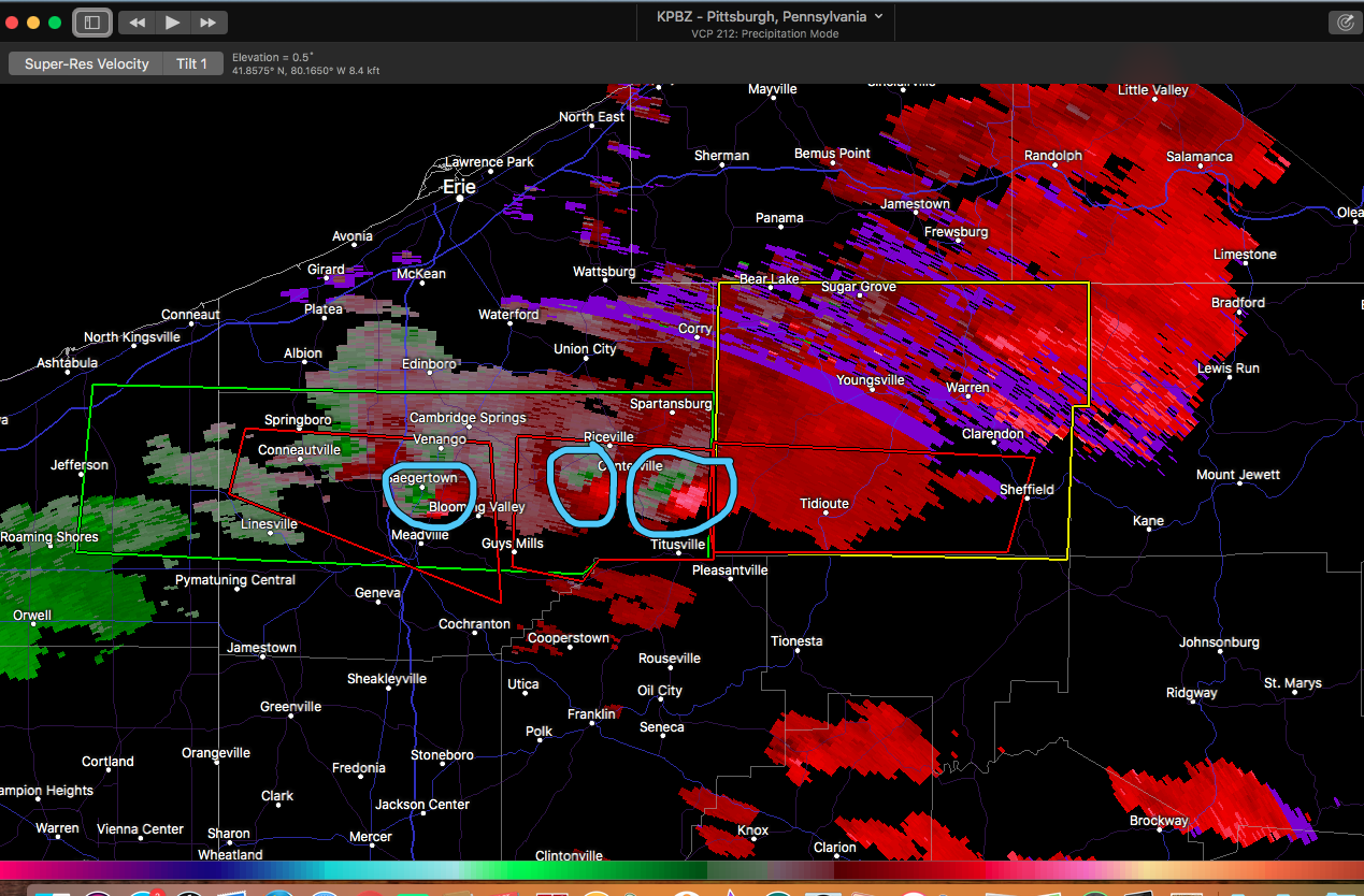
3 pretty distinct couplets evident on PBZ radar, with the lead couplet (the one with the CTP Warren County Tornado warning just issued most pronounced. Far NW PA isn't overly great for radar coverage at the low levels. PBZ is about the best but beam height is 7-8k feet or so.

-
Tornado Watch #392 issued for a sizable majority of PA minus the southern tier counties within the last hour effective until 11pm. Happy October!
NW PA really under the gun right now, new tornado warning issued for Crawford County, of the PDS variety.
QuoteTornado Warning PAC039-022015- /O.NEW.KCLE.TO.W.0009.181002T1939Z-181002T2015Z/ BULLETIN - EAS ACTIVATION REQUESTED Tornado Warning National Weather Service Cleveland OH 339 PM EDT TUE OCT 2 2018 The National Weather Service in Cleveland has issued a * Tornado Warning for... Northwestern Crawford County in northwestern Pennsylvania... * Until 415 PM EDT. *
At 338 PM EDT, a large and extremely dangerous tornado was located near Meadville, moving east at 35 mph. Another rotating storm capable of producing a tornado is 5 miles west of Conneautville, moving east at 35 mph toward Conneautville. This is a PARTICULARLY DANGEROUS SITUATION. TAKE COVER NOW!
HAZARD...Damaging tornado.
SOURCE...Radar indicated rotation.
IMPACT...You are in a life-threatening situation. Flying debris may be deadly to those caught without shelter. Mobile homes will be destroyed. Considerable damage to homes#commaOrEllipsis()businesses#commaOrEllipsis()and vehicles is likely and complete destruction is possible. *
This tornadic thunderstorm will remain over mainly rural areas of northwestern Crawford County, including the following locations... Venango, Conneautville, Woodcock, Saegertown, Blooming Valley and Springboro. PRECAUTIONARY/PREPAREDNESS ACTIONS... To repeat, a large, extremely dangerous and potentially deadly tornado is developing. To protect your life, TAKE COVER NOW! Move to a basement or an interior room on the lowest floor of a sturdy building. Avoid windows. If you are outdoors, in a mobile home, or in a vehicle, move to the closest substantial shelter and protect yourself from flying debris.
&& LAT...LON 4171 8050 4180 8047 4178 8002 4156 8000 TIME...MOT...LOC 1938Z 276DEG 32KT 4170 8018
TORNADO...RADAR INDICATED TORNADO DAMAGE THREAT...CONSIDERABLE HAIL...1.00IN
-
51 minutes ago, Wmsptwx said:
Lol...dude we honestly won't know ...it's where banding develops and storms form moreso not shield rain. HRRR has been awful all day.
I think we've recovered enough the last several days that a 1-2" general rainfall will cause some decent responses to waterways but likely not many flooding issues. As you mention, we will have to watch for bands that could train over the same areas wherever that may be this evening. Given we have a tropical system and associated extremely moisture laden source region, any bands will have intense rainfall. Shorter term rainfall (1 and 3hr flash flood guidance) is still where we remain quite vulnerable while longer duration (6 and 12 hr guidance) had improved the most. This is starting to look more like an areawide event where most waterways reach caution or perhaps minor flood in places with these potential areas of banding providing scattered areas in our region with perhaps more significant flooding issues vs an overall widespread flooding event like we achieved a week ago.
23 hours ago, canderson said:I’m so f’n done with heat. Today sucked. Where is fall?
Me too, I'm over this summer. If it hasn't been raining 75% of the time.. it's been very warm and especially humid. Unfortunately I think we're going to be taking an above average temp regime into October as I don't see much changes (or major catalysts to flip the pattern) the next 6-10 days. We're already over halfway through September, temps cracking into the high 70s/low 80s would be considered above average for most everyone. There's a lot of low height's progged over Canada and Greenland, which drives up heights south of the border in the US (+NAO/AO). This persistent pattern of high heights in the east and displacement from the mean storm track (well to the north) has been why we've been in this exceptionally stagnant pattern. We've been long overdue for a major shift in things, so I would expect we may see that as we get into October.
I'm not sure what to expect yet as we get towards winter. We've been running essentially ENSO neutral all summer with modeling developing El Nino conditions as we get into the winter months. I currently would anticipate weak El Nino or perhaps a + biased ENSO neutral, which may influence but not necessarily dictate our winter pattern. CPC just put out a new ENSO update today which can be looked at HERE. Another thing of note is significant positive SST anomalies off the eastern seaboard. If that were to persist into winter that could influence a more feisty regime of coastals and maybe drive some higher heights into the NAO region that has been so lacking in positive influence in our winter weather the last couple years. Other than that, I don't really see any glaring things that would tip me off to having to be concerned about anything either side of normal at the moment. It'll be interesting to see if we carry this amazing run of above average precip into winter.
-
1
-
 1
1
-
-
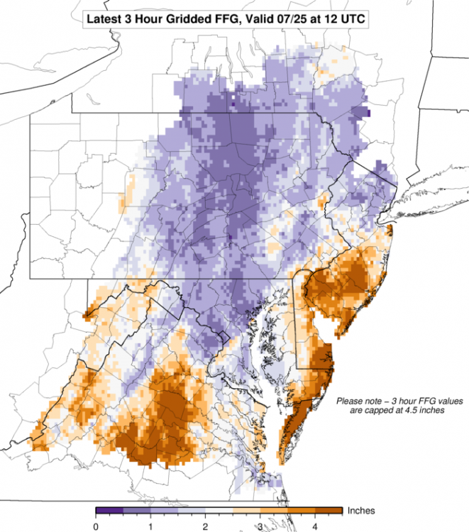
The Euro op has been easily the worst scenario the last few runs for central PA. Today's 12z run having a 2-4+" swath of rainfall through most of C-PA and LSV with the highest totals concentrating on the area that was affected the most from the flooding at the beginning of the week. It seems that the Euro maintains the core of what's left of Florence more than other guidance.. making for what would look to be a 6-12 hour timeframe of intense rainfall traversing the region Monday night. With how low the flash flood and headwater guidance is right now, that type of scenario would make for major issues. Esp in the JST/AOO/UNV corridor where headwater guidance shows that 2-3" or so in a 6 or 12 hr timeframe would send several of those smaller rivers into major flood stage pretty easily. Sus Valley is a bit better but still quite vulnerable to this type of a precipitation event as well.
Those FFG numbers could improve a bit the next couple days but it will remain pretty saturated throughout the region. Other guidance currently doesn't show such excessive rainfall, but even half of what the Euro has would still cause issues. One must also note the source region of this potential precip event (tropics), as even scattered activity associated with the remnants could yield intense downpours.
-
The rain has finally started to relent around here, after being non-stop since about this time SATURDAY afternoon. In terms of the flooding on the local rivers this is probably the worst since Ivan in my immediate local area. Lots of road closures.
-
It literally has not stopped raining here in the last 30+ hours, with the rest of the overnight and Monday to go for this event. Flooding issues have been steadily increasing with several road closures being noted and some of the local waterways cracking flood stage.
The prospect of Florence potentially impacting our area at the end of the week definitely has my attention as I am very concerned about the flood potential from such an outcome. This current event (remnants of Gordon + frontal boundary) is already concerning enough as it looks to generate a pretty widespread flooding event throughout a large section of the commonwealth by later tomorrow in addition to what's already occurring. Some of the heaviest rainfall rates could occur later today with the passage of the frontal boundary and the potential addition of a more convective element to the rainfall vs the stratiform rain that has been occurring over the last 24-30 hours or so.
The most worrisome thing when it comes to Florence is the potential for it to stall out. Modeling builds a pretty commanding eastern ridge with significant + anomalies over Quebac/Ontario. It's starting to becoming evident on the models that there might not be anything to recurve the storm or at least kick the storm out quickly in the event of an eastern US impact. Right now the last couple runs have been focused more with a stall in VA/lower Mid Atlantic after a Carolinas landfall. That's really not any better down there, as the entire Mid Atlantic region (in addition to us) have been extremely wet this summer. When I look at this potential I quickly think of 2004's Frances/Ivan combo. The heavy rain and flooding that occurred with Frances the weekend before really helped set the stage for the major flooding that came from Ivan. One could argue the flooding potential is even worse with this. 2004 was nowhere near as wet in the couple preceding summer months as this summer has been. We will have to watch Florence and the future model runs very carefully this week... I'm def concerned.
-
1
-
-
Today was the Altoona/State College region's turn to receive significant flash flooding issues in places with 1-2"+ falling within about an hour or so this morning. Parts of the State College region were hit twice (once overnight and then mid-late morning). WTAJ-TV's facebook has plenty of pics/video of the action this morning. Bigger rivers like the Frankstown and Little Juniata Branches of the main Juniata River did not quite reach flood stage.
I came across a closed road in my travels this afternoon hitting some back roads between State College and Altoona...Kind of a classic example of why you shouldn't cross a flooded road. You can tell a portion of the one lane has been washed out.

For this summer as a whole I personally can't recall one that has ever been this consistently wet around here.
-
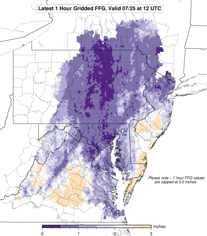
1 and 3hr flash flood guidance (as of 12z this morning)... ouch.

-
Tonight's action is focused right up the Susquehanna mainstem to the merge with the West Branch and up that through IPT....coinciding with a corridor of very high PWATs greater than >2". Not a tropical system but it essentially might as well be given the rich moisture fetch and high rainfall efficiency. You Sus Valley folks always know how to do the heavy rainfall events right.
-
46 minutes ago, 2001kx said:
How is it your way MAG?
Tornado?
Nothing crazy just some pretty good downpours and a little bit of wind. There wasn't much of a couplet noted velocity-wise on approach and the portion of the storm that contained it went a bit south of here. Still was a little bit of excitement.. I can't remember the last time I was under an actual tornado warning.
10 minutes ago, Voyager said:Tornado Warning north of Berwick...
That storm had a much better velocity signature, which has faded in recent frames (still there though). There was a brief point that it had nearly 90-100knots gate to gate so that had a much better chance of something possibly on the ground.
-
1 hour ago, maytownpawx said:
Any accumulations? i was looking at cams from the Laurels this morning and it looked like a couple of inches had fallen there. Regardless...enjoy!
I can vouch for far western Cambria County having an inch or so this morning on the US 22 corridor at one of the high points (Chickaree Ridge). Nothing on the roads though despite it snowing pretty hard. Tuesday was a different story as there was snow on the roads up there that morning. The Laurel's have been something else this month.
-
Some snowflakes mixing in with the lingering rain here. Couple 511 cams just up the mountain on US 22 showing a coating on the ground. It was nice knowing the brief two days of early summer warmth haha.
-
The remaining snow earlier did start accumulating on all non paved surfaces as dusk rolled in. Variable accums from 0.6" on the deck and grass to 1.6" on the glass table and probably on the trees as well. I'll call it about an inch on average.
Yet another spring event with mid-winter rated snow crystals. This stuff is sparkling dendrites and aggregates.
-
Been snowing steadily for most of the afternoon. Accums have been mostly relegated to heavily shaded spots, sheltered pines, and some cold elevated surfaces. Deck is just wet, but the glass table on the deck has 0.8" of snow on it. Probably would have been a 2-3" type event if it had been night-time. All of this on a SE wind too, in April.... Heck of a way to run spring.
I slept in Sat morning so I saw some of the shaded leftovers of Fri Night's snowfall when I woke up late morning. That one was likely a 0.5-1" or so event. Was in Cambria County today (next county over from me) and there was still thick patches of snow and plow piles in parking lots in Ebensburg from whatever amount they had Sat morning. It was likely of the several inch variety.


Central PA Fall 2018
in Upstate New York/Pennsylvania
Posted
Snow/sleet mix here now.