

MAG5035
-
Posts
5,718 -
Joined
-
Last visited
Content Type
Profiles
Blogs
Forums
American Weather
Media Demo
Store
Gallery
Posts posted by MAG5035
-
-
Just now, bubbler86 said:
This place is like a virus when it gets the Mets to say Caved. LOL. I hope you are not getting "fatties" right now.
Just figured I'd speak the lingo haha.
-
Looks like almost a half inch. The streets have "caved".
-
7 minutes ago, JTrout said:
Did the ICON do any good with our NOV storm? I can't remember.
And does anyone think the snow cover to our south could help lock in some cold better then currently projected?
I think the cold up north under the high pressure will have more to do with longevity of surface cold. Some parts of southern Quebec are supposed to be in the -10's Saturday and down into the -30s for lows. The arctic cold is there. High pressure is moderately strong but the pressure difference is more significant with the robust low pressure coming from the south. I think surface/near surface cold transport via ageostrophic flow will favor the colder guidance and thus I think there may be a more expansive ice threat in the mixing areas.
-
Moderate snow falling, coating starting on unpaved stuff.
-
6 minutes ago, 2001kx said:
You gonna have a snow map / numbers for the storm?
I'll probably at least throw a discussion with some numbers out prior to the storm. I'm probably going to look over tonights 0z guidance first though. You continue to look in good shape for a big snowfall before any mixing, if it ever comes there. I would feel comfortable saying 10+ is looking fairly attainable in Clearfield.
-
Light snow has started here by the way, from our much lighter system for tonight.
-
Doing some heavy scrutinizing of 12z model data, since we're getting down to the short range with our weekend event. Looked pretty hard at the major models thermal columns comparing GFS, EURO and NAM at 850mb and 925mb levels. The GFS is on it's own thermally compared to the Euro/NAM despite similar tracks and heights with the 850 and 925mb lows. GFS might be broader and further into PA with the 925mb low but the point is that the GFS is way warmer aloft. Now I will say the 850 low track is a bit NW than you'd want to see for heavy snow in the LSV and south central counties (focus more on north central and northern tier) on all three. However I continue to think that even if it does rain in the LSV it's going to be after an extended period of snow/mixed precip. The exception could be the southern tier below the turnpike in the LSV SE of I-81 but even there I'm not fully convinced of any kind of an extended rain event.. although there it likely will change to plain rain for a time unless guidance starts shifting the other way some in the short term (entirely possible). If the surface low did end up on or breaching the M/D line that also introduces the possibility of getting slotted anyways when it gets too warm in the far southern tier.
With the temp discrepancy on the GFS an example is hour 66 for the 12z guidance today (which is the warmest frame before the storm starts going to the coast and rapidly bringing the very cold air in). At the 925mb level, Harrisburg is on the 0ºC line on both the NAM and Euro, while on the GFS it is at +6ºC (!!). It should be noted that the GFS gave most of the LSV a nice thump of snow regardless. But I can't support low level temps that warm with the setup. While not an ideal alignment we do have a high up north and there absolutely is arctic air available. I have to side with colder guidance on that regard. I would imagine it might be a reason that CTP has seemed very bullish on the wintry potential of this event.
-
 1
1
-
-
1 minute ago, paweather5 said:
That would be like the Central PA and Pittsburgh forums combined dream come true if that happened.
-
2
-
-
3 minutes ago, bubbler86 said:
Thanks for that. More good news. Big picture things are trending toward that LP staying south of us.
I think if the low does just that and doesn't press into PA or get really close to the mason dixon line that things will eventually work out for the majority of the forum in favor of mostly the frozen stuff. We don't really have a mixed bag of guidance with some models cutting west or through PA vs going south. We're getting down to resolving the details of p-type, which of course is always the hard part with these types of systems.
-
3
-
-
Geesh, GFS has the low centered near the VA/NC line at hour 78 and it has p-types as rain all the way to IPT. I doubt that.
-
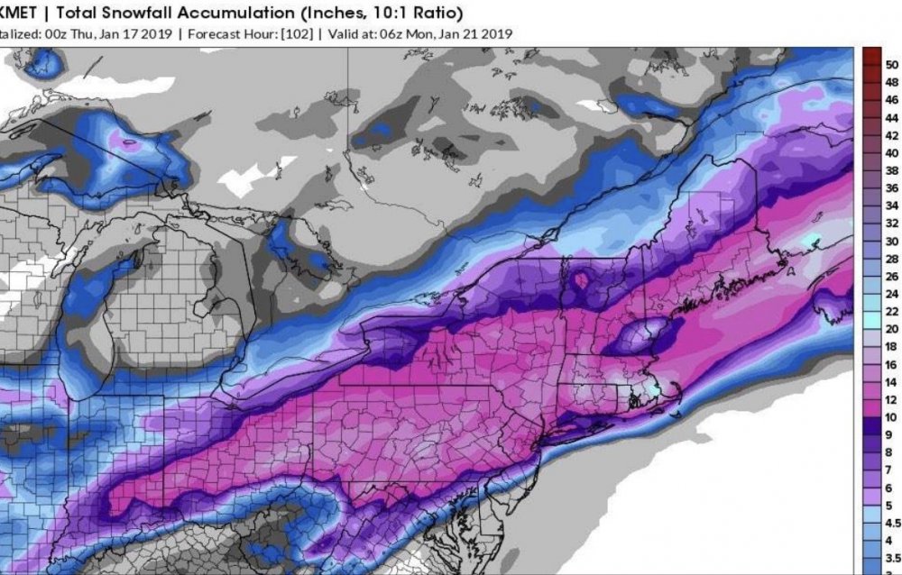
Tropical Tidbits snow maps are notorious for showing excessive snow totals below what would be the mixing line. It says right on the map "includes sleet", and we know sleet doesn't accumulate anywhere near a 10:1 ratio.
Here's Accuweather's 24 hour with Kuchera.
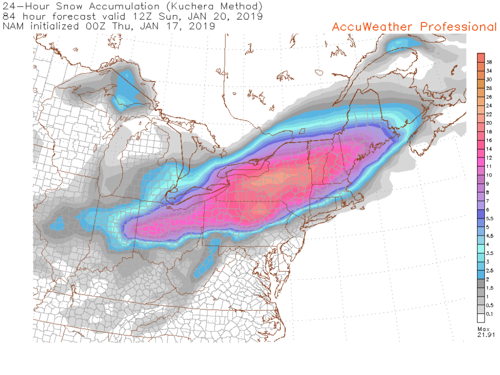
That's probably a more accurate representation of accums given the p-type arrangement that the NAM had. Just using as an example really.. the only thing I really took from the NAM at this range is that it kept the low below PA.
-
27 minutes ago, Superstorm said:

.25 minutes ago, daxx said:Mag, Williamsport and 2001 should be dancing in the streets with that run!
Woof
-
26 minutes ago, Wmsptwx said:
Mag not to be mby guy but you think we see sig icing?
Possibly, although your in a good spot to see a lot of snow before any changeover as things stand attm. You and 2001kx are looking the best out of the bunch right now.
-
3 minutes ago, Itstrainingtime said:
It's also once again showing an ugly look at the end of it's run. Hopefully it's wrong.
MJO has quietly been forecast to make another round through 4-6, though probably not at the magnitude or longevity of December. I wonder if that may be starting to have an affect on the long range stuff a bit.
-
3 minutes ago, bubbler86 said:
Try to find some gems in the rough here....CMC/GEM is still close to a lesser phased solution. We are still in play here.
CMC vs GFS at 90hr actually illustrates more of a difference in the thermal column. CMC's low pressure actually a tad further NW than the GFS at that frame but better front end snows. Looks like it has more of an attempt at a secondary coastal low too.
My experience with these types of storms is typically that reality ends up being a bigger fight on p-type transition in the central counties and sometimes the LSV.. especially when theres a good frozen front end and some high pressure above us. Surface-925mb temps aren't easily routed in the ridge and valley region of central PA. This type of track suggests to me a potentially more extended period of icing in the AOO-UNV corridor and between I-80 & I-78 and west of I-81 in the Sus Valley. And I'm talking the track that the 12z guidance is putting up so far. But these regional tendencies don't typically show up on the global ops til pretty late in the game.
With said regional tendencies in mind, this is the range and situation right now where using ensemble blends and putting more weight on those ops supportive of the general consensus via ensembles is probably the best move to get a rough idea on possible impacts.
-
We seem to be faced with this type of scenario at least once or twice a winter.. a moisture laden storm system approaching from the MS and OH Valleys with the potential for significant winter impacts, where eventual track is key to whatever wintry or non wintry scenario we end up with. Without much Greenland or Canadian blocking available, this thing can cut it if phases early/too much.. which makes it a touchy setup. Thus, I'm pretty surprised at the specific details being thrown out by forecasting sources at this point of the game.. be it playing with D5 snowmaps showing 20-30+ in the viewing area, NWS discussion throwing out actual numbers in the long term section for this storm, or stating LSV is getting a big rainstorm. None of those things are anywhere near a certainty right now. I've been approaching this storm as of the variety where winter impacts are likely, but specific details are not going to be resolved for another couple days.
With all that said, even with the scenario where the low cuts just west or through PA... there is likely going to be front end wintry issues to be had in the form of front end snow and ice. Not the most ideal CAD setup but it's certainly workable with plenty of cold available and mid-late Jan climo on our side. The center of high pressure is modeled above MN/upper lakes, but the high pressure sprawls across the rest of eastern Canada. I find it unlikely right now that anyone in our subforum would see a straight rainstorm from this whether it cuts or not. Overnight model runs seemed to start coming back a bit from looking decidedly more wet yesterday so we'll see if they start getting under PA more. If the low pressure does skirt underneath most of PA or secondary development to the coast occurs this will be a significant snow and ice storm for most if not all of the subforum.
-
 3
3
-
-
11 minutes ago, Atomixwx said:
I found out what the deal was. It was Murgo on Facebook showing a graph of the GFS and Euro in agreement last night. Apparently it scared the natives.
Oh boy, lol. He better hope we get every tenth of that 29.3... the natives can be pretty savage.
-
1
-
-
7 hours ago, Atomixwx said:
My buddy told me that WTAJ in Altoona addressed both the GFS and EURO last night saying agreement on 20". MAG may be able to confirm that.
I heard such things from somebody this evening, though didn't hear where it came from. I can at least confirm someone with a TV camera and/or social media must have been slinging out clown maps.
-
4 minutes ago, pasnownut said:
Yeah. Your right. If we had the activity here I wouldn’t go there. Too clicky but I like talking bout snow....so I go. I liked today’s storm over a week ago as things looked good to me pattern wise and no one said boo. One if the sacred ones says something and 95 people like it. That gets old.
Lefs have some fun here in the next few weeks.
It was pretty quiet in here during the lead up and discussion didn't really pick up until the last day or so. I also didn't realize we lost two of our more regular red taggers in here. I did remember Millville moving but I didn't know Heavy_Wx moved too (saw him down in the Mid-Atl thread).
I think we'll be having plenty to discuss now haha.
-
2
-
-
This potential system next weekend that has been strongly hinted upon by the models could be the true big hitter we've been waiting for to show up. I know it's funny to say that in the midst of being impacted by a pretty significant system right now but the pattern progged shows the kind of amplification in the pattern we've been missing to wind up a big one. Track's going to be obviously the big thing to watch the next few days. It could cut up too soon or perhaps end up east. Recall where this current storm was several days ago for a time.. impacting our whole subforum significantly. I do think the pattern may support more of a coastal solution vs inland or cut.. we have a nice western ridge where we need it and the PV well established over Hudson Bay which I think should help keep the storm track low. There's also some kind of preceding system that's been showing up beforehand (Friday-ish), that may also have some bearing on the potential bigger system while also providing another snow opportunity of course. It might not end up being -20 at any point but looking into the extended there's a lot of arctic air that seems poised to be released into the eastern US at a time of the year when it is climatologically the coldest.
36 minutes ago, pasnownut said:Yeah that was an overachiever for them. I’m glad for them but hope they aren’t as snippy for a while as you are right, it’s our turn. Gfs is great but we need a southern trend for next weekend. CMC says no.
Lol I'm glad that January was cancelled ~10 days ago, imagine how bad it would be if it had actually showed up.
-
2
-
-
Just barely got to 2" by this morning. We'll see if we can add to that here this afternoon as radar trends suggest a new period of snow might be imminent with snow building back in western PA towards Pittsburgh (and even all the way up to near Clearfield and Punxy).
-
Steady light-moderate and at about 1.5" so far for this event. My target accum for here was 3" and so far this storm has been going as modeled without any extra enhancements to make for any surprise higher totals.
-
At the 1" mark. Light snow continues
-
Light to moderate snow, 0.6".

Central PA - Winter 2018-19
in Upstate New York/Pennsylvania
Posted
Yea they're trying to be more proactive with sending out special weather statements. Typically for snow squalls although I guess this would kind of qualify, plus it's evening rush hour.
Speaking of statements, the winter storm watch is one of the more strongly worded ones I've seen recently.