

MAG5035
-
Posts
5,718 -
Joined
-
Last visited
Content Type
Profiles
Blogs
Forums
American Weather
Media Demo
Store
Gallery
Posts posted by MAG5035
-
-
8 minutes ago, Voyager said:
Your cold air is out in Flagstaff, AZ where I'm spending the night tonight. Currently +5 degrees here...
Lol, gotta love radiational cooling at around 7k feet. It's showing up nicely on the IR. Since it's clear, the cold mountains are showing up nicely and Flagstaff area is matching nicely with ground obs (IR showing -15 to -20ºC range). Might have to watch for unsettled weather and relatively low snow levels if your still in the Four Corners region over the weekend.

-
4 hours ago, psuhoffman said:
@MAG5035 one other thing...imo its not so much the storm track but the total evacuation of cold over the CONUS by the pacific jet blasting into the west coast. We have had several darn near perfect H5 passes over the past few weeks that have yielded nothing but heavy cold rain because the antecedent air mass was wrecked. We have another such event coming up. Yea there have been some cutters too but that happens in almost every pattern even a good year. 2010 there was a big rainstorm that wiped out my snowpack xmas night. Another big cutter in January. 78 had the famous ohio valley blizzard. Plus some of those cutters...given the h5 track, likely wouldn't have cut at the surface if there was a cold airmass in place ahead of the storm. Because the thermal boundary was so far northwest the surface systems tracked well west of what would be typical given their upper air patterns. If we could just get some cold, any cold, we should do very well given the recurring storm track since about mid fall.
Nah I didn't think you were suggesting that about the MJO in the analog years, I thought you had a great post. It was just something I was looking into and was kind of surprised by the results. That archived data goes back to 1975, and it actually is hard to find an MJO pulse with a stronger magnitude like the current one through those phases. Mid Feb '85 about left the chart in phase 4-5 (84-85 was a weak to moderate nina). Jan '86 (borderline weak nino), Jan & Mar '90 (neutral), and Feb '94 surprisingly enough (neutral) were a few other examples. So I think these weaker ENSO episodes can be a bit of a tossup. We're running nino conditions but it's not overly strong, and OND would be only the 2nd consecutive 3 month average with nino conditions. You need 5 consecutive to actually confirm a full blown nino episode.
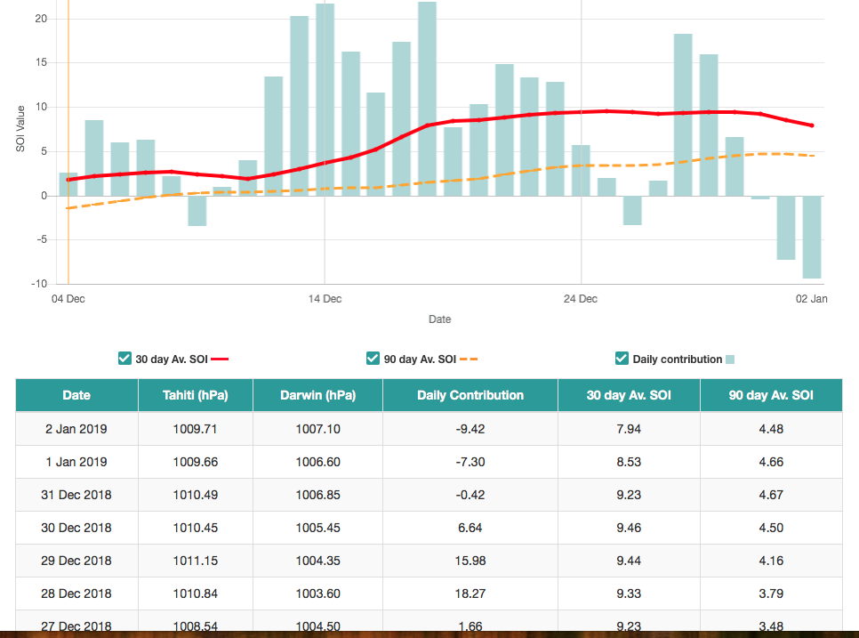
Now on the SOI. The SOI is a index derived from the pressure difference between Darwin, Australia and Tahiti in the middle of the western Pacific. It's more of a longer term index (using a 30 day, monthly and 90 day average) but daily values are calculated to pick up on trends. And we can see the latter part of the month the 30 day average cracked into Nina territory (value of more than +7). The 90 day average has not. The more positive SOI through most of December could possibly be indicative of the MJO pulse itself as those 4-6 phases coincide with that region. +SOI values come from Darwin having lower pressures as compared to Tahiti. So theoretically there's some support for a reversal of this trend as the MJO pulse is progged to progress to 6-7. I had to go to the Aussies to get a good source for SOI data since a lot of American stuff isn't available right now, specifically from the National Climatic Data Center due to our Gov't shutdown. Site is HERE. I put up a screenshot, and you'll note the last two days of daily values have had negative values. Beginning of that SOI crash in Jan trend? Potentially.
So onto our pattern here in the US. I do agree about the next storm coming up track-wise. 500 low and surface low track should say snow event for the Mid-Atlantic. Evacuated cold will ensure a different result. I didn't think we've really had an all out flooding of Pac air across the lower 48 til this period coming up in the short-mid range. I know your region further south has probably been a different story (milder) but up here it hadn't been particularly warm. It was seasonably chilly or perhaps a few ticks above until we've had the last couple cutters approach. Temps rise in response to the storm going west and go back to chilly. But yea either way we haven't had an actual real cold antecedent mass to work with. As I mentioned previously, the northern branch has not been very involved, staying north mostly and keeping actual cold air excursions to the north or brief when they do dive down. On the other hand it hasn't been a full blown eastern ridge and torch, but theres been enough southeast ridging and low heights in the Pac and west to send the last few storms to the Lakes. The pattern is quite progressive... we don't seem to be locked into any major feature good or bad but we keep coming up on the wrong side of things. It's been a weird thing the last month or so. It's like a progressive Nina with an active Nino southern stream. I do remain confident that we will straighten things out within the next few weeks I just hope that we don't throw the majority of Jan away.
-
 1
1
-
-
19 hours ago, psuhoffman said:
Thanks and happy New Years!!! I should post up here more, but I guess since I lived in the DC area so long during the early years of the weather boards...once I moved back to northern MD I gravitated back there. Also there is usually more activity down there in that forum (mostly because of the greater population in that area I would suspect) during non storm threat periods. But I will try to pop in up here more often, I certainly enjoyed my time in this forum back in 2013-14.
I have been calling for a flip to a colder pattern sometime mid to late January and I still feel confident in that. A lot of the analogs that had somewhat similar features to this year...1958, 1966, 1969, 1978, 1987, 2005, 2007, 2015... featured a pretty craptastic mid Dec to mid Jan. Then sometime between Jan 15 and early Feb they all flipped. Some ended up epic, others simply respectable but they all got colder and snowier the second half.
As for why its been so awful lately and when the flip comes I really do think the mjo has been in the drivers seat. It makes too much sense. Most of the time the obvious answer is the correct one. The pattern really flipped on a dime when the mjo decided to go ape into the warm phases. And looking at an mjo correlations map the actual pattern the last couple weeks, and the projected one next week, look so closely like the expected mjo phases that its too much to think it's a coincidence. Add in that the mjo has been at near record amplitudes for the time of year and nino and its hard to ignore it as a driving influence.
The soi being in nina territory is also not helping. I think there is likely a connection between the soi and the mjo. There is a correlation with the soi spiking during strong phases 3-6 and also a correlation with a muted mjo during el ninos. I don't know which is the chicken or the egg there but there is some linkage. There is also a correlation with the mjo into warm phases and the initiation of a SSWE so all that seems to be cascading to bring on this pattern and mute the nino background state. The end result being the increased tropical convection in the east Indian Ocean and north of Australia is derailing and running interference with the formation of a nino pacific pattern or the atmospheric coupling with the sst patterns. In essence we are in a strong la nina pacific firehose pattern despite the sst.
However, I am not overly concerned yet for the rest of winter. All of the seasonal and sub seasonal guidance (other then the cfs which I largely ignore) keeps trying to go to the exact same look. The euro weeklies, euro seasonal, ukmet seasonal, JMA weeklies...all look the same. But as the pattern approaches they back off and delay. Tonight's weeklies again go to the great look but pushed it back a week again. Why? The most logical explanation is the mjo again. The guidance is seeing the sst and other factors that indicate what the base state should be...and its the exact same look supported by the analogs I identified earlier and the sst pattern. Take Joe D's Pioneer model. I know wxbell is biased but that model is really just a sst analog output and it looks identical to the pattern the long range guidance keeps wanting to go to. But analogs aren't perfect. They don't take into account changing conditions and all factors, and the oceans SST arent the only pattern driver. They are by far the most significant one but at times other things can influence the pattern one way or another.
But we know the guidance struggles with the mjo at range. So it seems highly likely given that when the mjo went berserk is when things went wrong, and the pattern keeps matching up with the mjo phases perfectly, that the long range guidance is simply failing to properly account for the current mjo and soi incongruousness with the nino sst. So long as the soi and mjo remain in warm phases it is likely the pattern changes in the long range guidance is wrong. BUT...there is historical evidence that a strong soi spike during a nino in December is typically followed by a crash in January. It would also be almost unheard of for the mjo to spend an entire winter cycling through phases 3-6. Sooner or later both of those factors are likely to flip. At the very least the mjo is likely to become less amplified at some point and the soi is likely to drop, it might be now as today entered negative territory after a recent spike. So I do think once those two things sort themselves out the good look being teased by the long range guidance is finally going to become a reality.
Of course that still doesn't guaruntee a specific location a great result. All of those years I listed above gave SOMEWHERE in the east a great second half snow wise. But not everyone. 1987 targeted the DC to Philly area. 2007 nailed further north. 2005 was a new england special. But every one of those years turned colder and somewhere got a snow blitz. Discreet details within the pattern that are impossible to infer at range will determine the fate of a specific location in regards to snowfall. Snowfall is incredibly fluky in general. Its a relatively minor areal coverage that gets significant snow with any synoptic event. When you are missing by 500 miles its a bad pattern. When you are missing by 50 miles it's more often bad luck. But get the pattern right and we all stand a chance...then its up to luck who ends up with a great finish and who simply had a respectable one.
It's been crap lately, and the frustration is legit but I still am optimistic things flip within the next month and we have some good times ahead. If I fail because of something unprecedented like an MJO wave that cycles around in warm phases all darn winter or an SOI that stays in nina territory all through a nino winter so be it, but I find that unlikely. So far this hasn't been that out of line with the analogs and until I see evidence this has gone wrong I will have faith in the evidence I listed above for a pattern change coming relatively soon.
Happy New Years and hopefully a snowy one.
I'm not an expert on the MJO by any means but Ive tried to understand its workings better and I've learned that trying to apply it to our sensible weather in our part of the country can be frustratingly difficult. Especially so when I really started to look at things. After I managed to find a source with archived MJO data, I spent some time last night after seeing your post with the analogs you laid out. It's not the first time i've heard about some of those years. 78 has come up a good bit as an analog to this potential flip. I expected to see a move to favorable phases earlier in Jan of 1978 and the classic 8-1-2 pulse or recircle to match up at least somewhat well with the major last half of Jan-mid Feb blitz. The archive data surprised me.
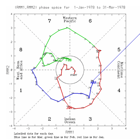
New England's Blizzard of '78 (the most well known of the two '78 blizzards) occurred Feb 5-7 as MJO was progressing back from 7-8 and the previous weeks massive 955mb lakes cutter that was the Great Lakes/OH Valley Blizzard of 78 was only over a week before Jan 25-27th while the MJO was progressing from 4-5. And just before that, on the 20-21st was another very major snowstorm that struck the whole Northeast (phase 4). Now MJO typically has some lag in it's effect in the mid latitudes, but either way it's really evident to me that it probably wasn't the number 1 driver in the pattern that caused the craziness of that particular period. A major blocking pattern (esp NAO region) was. Just looking up the stuff to make a post about this particular winter (I wasn't alive then) it's incredible how much of a blitz there was of storms in that few week period. It's similar to 2010's.
https://www.weather.gov/media/box/science/Blizzard_of_1978.pdf
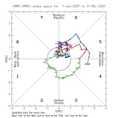
One of the more recent analogs, 2007 didn't really have much MJO influence when things turned good later in the winter, only creeping into very low magnitude 1-2 in mid Feb, but it largely stayed on the right side of the diagram just about the whole winter. There was a more sizable run through 4-6 in late Dec-early Jan but the entire winter overall was spectacularly dead on arrival until mid Jan in the east. Also, March was an active up and down month but did feature a couple late nor'easters that delivered significant snowstorms in especially the interior Mid-All/NE and look where the MJO was.
2007:
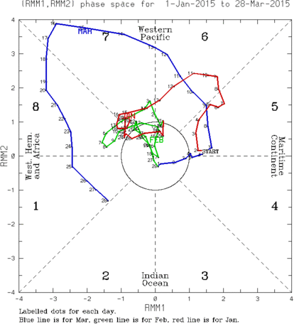
2015 didn't have much of an MJO connection either, but that was a winter I knew that it didn't because of the incredibly persistent and significant +PNA/-EPO pattern that kept us in the freezer regardless of what the other teleconnections were doing. That winter didn't feature much southern jet, and was more northern jet dominated despite weak El Nino conditions.. lending to less major impacting snowstorms in the region. There was a point it spiked into 5-6 in January but we stayed in largely a colder pattern due to the aforementioned Pac pattern.
So.. I've always approached this teleconnection by utilizing it as PART of the big picture but I was really surprised at the lack of connection/continuity to any of these analogs and actually just in general as I've looked a few other winters including some of the bad ones (including the infamous 01-02 "vodka cold" massacre). Like I wasn't expecting a smoking gun by any means but I expected to see some of these infamous wintry periods match up better. So fast forward to now, I do think the MJO in its unfavorable phasing does have a lot of influence currently... because we don't have a dominant state in the PNA or NAO realms. They're actually okay right now for the most part. But I'm talking an actual established blocking pattern whether good or bad for us. Our pattern has been progressive and I think the MJO phase state right now is aligning our storm track the wrong way in the absence of high latitude blocking. It sucks because I personally think we've had the best southern jet I've seen in years for sure. But we've seen very little connection with the northern jet thus far, which has kept a lot of the real cold air away. That's going to start eating into averages in interior locations that see more snowfall from clipper type systems, LES and upslope from cold NW flow, etc until we change. I'd be careful with the big hitter analogs right now, especially the likes of the '78 one. I can see the potential of this winter to get a period like that, but it's probably going to involve more than the MJO going into 8-1-2... although a good MJO pulse moving through those could help set up some blocking too. Additionally, the ongoing SSW event could help shuffle the pattern in that regard too. One thing's for sure, I'm ready to see something other than rain.
-
3
-
 1
1
-
-
The gusty winds have started arriving here and have promptly mixed the warm temps down to make for a temp all the way up to 58ºF attm.
I'll be sharing my thoughts later today on some of the specifics psuhoffman touched on in his post. Happy New Year everyone.
-
2
-
-
Absolute washout here tonight, and the temp is all of about 37ºF.. which has only come up a couple degrees all day. Miserable.
-
34 minutes ago, Blizzard of 93 said:
The EPS, Euro Control & GEFS agree that we get on the board with some snow in the 2 weeks. The MJO heading into phase 7 should help by next week.
Yea i did notice especially the NCEP GFS related guidance seemed to be more rapid in it's progression to phase 7. Euro guidance has been really insistent on killing the magnitude of the MJO pulse whether that's right or wrong.
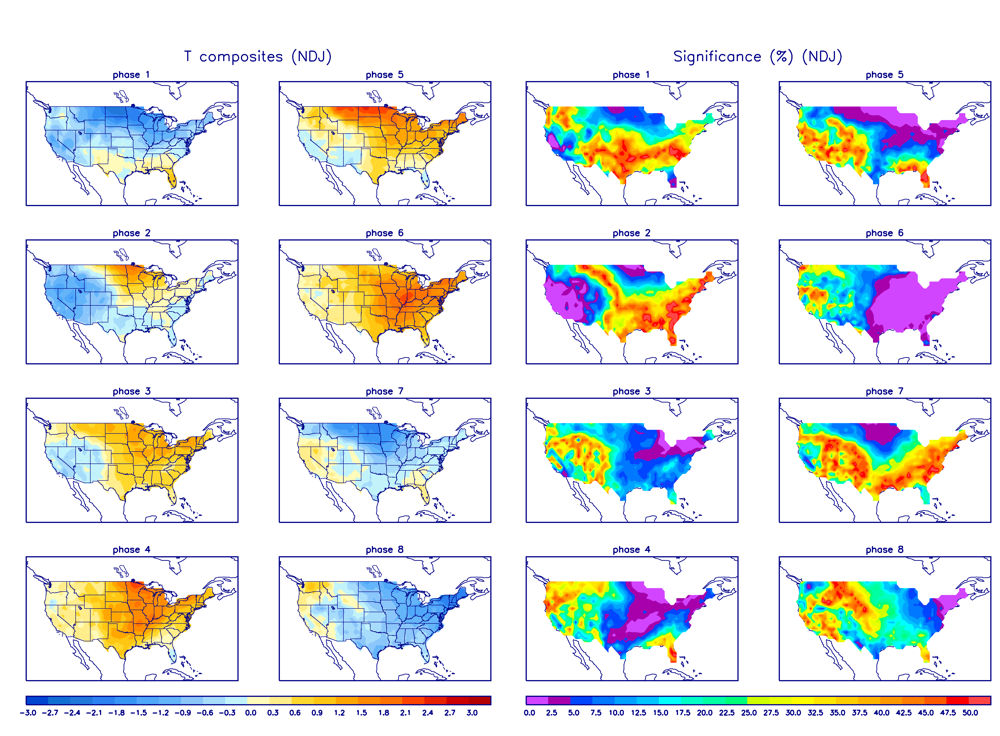
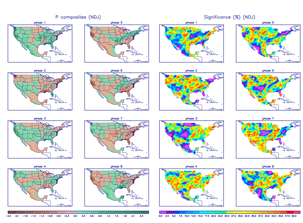
Phase 7 is a bit of a toss up in the east. Using NDJ average the phase is colder here but with a pretty decent degree of variability (more of a tossup) indicated in the significance maps while the DJF average shows warmer than average in the east and less variability indicated but still nowhere near the clear cut signature you see from 5-6. I've always treated 7 as a phase that can still continue to feature a pattern where we can still be vulnerable to cutting storms, but we're getting there. We also have the stratospheric warming conditions going on and people sometimes don't realize that that phenomenon takes time to evolve to see results at our latitude.. on the order of weeks.
-
This possible storm around the 4th has been showing some signs of being interesting but models are all over the place with it. Euro been most consistent with having an actual storm impact our area but it's been a messy evolution and detached from a cold air source. Today's 12z run does have a slug of precip under the upper level low with the cold pool of air which I would imagine would constitute at least an elevational snow threat after some initial rainfall. But it looks like something you'd see in October with it's marginal temps.
GFS has been colder here having a more pronounced northern stream shortwave passage to our north but also much more progressive/weaker with the southern stream wave that would be the impacting system. Most runs of the GFS really haven't made much here until 0z last night and especially 6z this morning before going back the progressive route 12z today. 12z Canadian looked somewhat close to the 6z GFS having a big system but somewhat warmer than that GFS run early this morning. GFS and Canadian progress the wave out with the Canadian having a much more robust and closed off 500mb low. Euro evolution has an even deeper closed off 500mb low that is much slower. Given progressive/positive tilted look to the pattern on models, I'd personally lean away from Euro's wound up and slow evolution and go for the more progressive solutions. It wouldn't be anything new if the Euro is hanging back southern stream energy. Questions will be is there going to be cold enough air around (especially for LSV) and if we have a robust enough storm to even make anything in this region. The potential track of this.. at least for now looks better than our last couple plus the one thats going to make us wet for New Years... closer to being a coastal than a lakes cutter.
I know we're in a unfavorable pattern right now but we're not in a impossible situation. It's not like our half of the country is 30 above normal and we have an eastern ridge to the north pole. One of these waves is eventually going to surprise us.
-
3 hours ago, bubbler86 said:
Hey Mag,
It was me that brought the above up and my thought was based on Decembers where there was not even a trace of snow. I only looked back to 1988 but from that point forward no December at MDT has ever gone by without a trace of snowfall until the potential of this one. 2015 actually featured trace snow fall recorded 3 times. Trace, no trace...still basically no snowfall but it takes a special kind of bad month to not have even a trace.
Here is the climate data showing a trace 3 times in December 2015 so if that is wrong then my premise is wrong as well! :-). The 3 green T's are under the new snowfall column.
I do understand where your coming from and I'm certainly not disagreeing that this has been a lousy month snow-wise. Back this way this month has accounted for only about an inch or so of the 13.5" I have to date when Dec generally averages roughly 8-10" here. It's been a tough month, we had a cold pattern for most of the first half of the month and missed out on a suppressed storm near mid month before the pattern switched in favor of cutting storms. We have not had any established blocking downstream to promote any consistent NW flow to promote very much snow in the LES belts or mountains either. We're just working through a period right now that has featured an unfavorable storm track but not necessarily a warm regime either, which I went into my thoughts on that in my previous post.
In the case of MDT I just think the difference between a T for the month and 0" is a fairly moot point. It was noted in that CTP discussion I posted that "any flurries count as a trace of snow". A T for the month would still imply there wasn't any measurable snow for that month. This current December is probably going to close out with zero snowfall in MDT if there hasn't been a T recorded to this point. So yea either way we're pretty much on level footing in that regard to 2015 and 11 other Decembers.
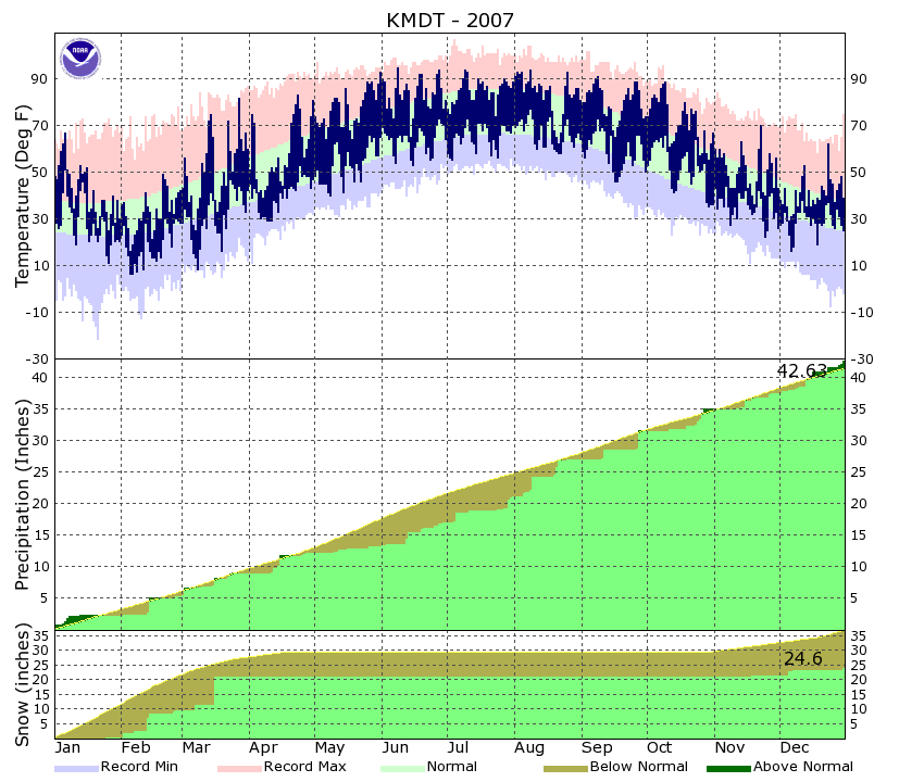
I'm more interested in the details that got us there. I mean look at those temperatures in that period of Dec 2015 you posted. You could probably put those numbers in for the last 20 days of October and still end up above average. The warmth in that December (and November) was unbelievable. I actually am surprised there was any snow recorded, and look at the temps during those days a T was recorded. But there is no comparison to this December temp wise. The temperatures for the most part this month have been typical of the month we're in aside from the couple warm days we've had ahead of cutting storms, but we have not been in any established warm pattern. If we're talking pretty unprecedented runs without meaningful snowfall, there have been a couple winters in the recent past where we've went way into January before some LSV sites ever even had their first measurable snowfall. Take that 2015-2016 for example with the T in December, MDT didn't have their first inch until January 22-23rd (which was immediately followed by about 30" or so more). 2006-2007 was another winter that had an absolutely awful start in the LSV. I'm pretty sure York/Lancaster didn't record their first inch of snowfall until early February of that winter. MDT might not have either, check out the graph. So moral of the story, yea this has been a lousy month but I can show you worse periods of no snow..and pretty recently too haha. And MDT is already 8.8" on the season because of November's snowstorm, which still would have them above average.
You can find these climo graphs HERE and they go back to 1999 for MDT.
-
6 minutes ago, paweather said:
That November snowstorm turned out to a tease for us. :-) GFS looked blah today. I remember back forget the year LSV had that Halloween snowstorm and then I believe it was lousy winter. I am wondering if the same thing happens this year.
It was October 2011 when we had that snowstorm and yea we had quite the lousy winter that season. 2011-2012 was a solidly La Nina winter so not really any similarities ENSO wise. I also believe Nov 2011 was one of the warmest on record if I recall correctly.
-
I know there was fair amount of commentary in our previous thread right before the new one got made about the general snowless..ness we've had this month, especially in the LSV where snowfall has been basically zero. A snowless or near snowless December is certainly not something us winter weather fans want to see, but it's hardly unprecedented in the LSV. CTP had some stats in their disco this morning, which I've been trying to find.
Per CTP, also included their input on the yearly rainfall bc that is something that has definitely been unprecedented.
.CLIMATE...
Yearly Precipitation Record Watch...

Station  Precip in 2018   Rank   Record, year
-------  --------------   ----   ------------
KIPT       68.74           2     70.26, 2011
KMDT       64.96           2     73.73, 2011
KAOO       54.62           2     57.32, 1972
KBFD       47.44           20    60.65, 1992
KJST       60.15           1*    60.58, 1927**
* Record value for the airport
** Record for all historical reporting stations in Johnstown

0.5" to a little >1" rainfall is forecast for Thurs night and
Fri.

Johnstown is almost certain to eclipse that 60.58 and set their
record wet year.

This could (but probably won`t) push KIPT over their record.
They just need 1.52" to set the record. Current forecast precip
total for Thurs night-Fri wouldn`t put them over. But, it could
be close.

The other sites probably won`t get to their respective records.
Harrisburg needs to add about 9" to get there.

So far...ZERO snowfall for Dec for KMDT. There have been 12
Decemebers with a Trace or No snowfall in Harrisburg. The last
snow-less Dec was 2015. (Any flurries count as a Trace of snow.)

Just a Trace of snow has fallen this Dec at KIPT. Williamsport
has had 9 Decembers with a Trace or No snowfall - last was also
in 2015.
I'm not sure how far MDT's obs go back. Weather Underground's historical for MDT goes back to 1935, which would make for approx a 14% rate for T or less Decembers at that station if that's how far back it goes. At any rate it's happened before, several times. The thing about this winter is we are still running average to above average to date because of November. Sometimes that's the disadvantage of getting an established winter-like pattern early. November was a quite a wintry month, especially the 2nd half of the month. The pattern this month simply has not been as favorable, especially with storm tracks. Mother nature doesn't much care about month to month snowfall averages. We could have gotten that big snowstorm on November 30 and we'd still technically have a deficit for December.
Looking at the pattern going forward, my personal opinion is we got to get the MJO out of phases 5-6 and in the meantime we will continue to have trouble with cutting storms..even phase 7 too. The GFS, GEFS has especially been forecasting very high amplitude to the MJO pulse running through 5-6 . We've been running an active southern stream so far this winter (Nino type winter) so I think the tropical forcing that makes the MJO tick is having a heavier influence, esp in the absence of much of a really dominant feature in the traditional teleconnections (for example dominating Pac ridge or trough, established blocking via -NAO, etc). I thought the storm following tomorrows cutter would be one to watch for a potential swath of wintry precip but models have since started to zero on another cutting storm bringing mostly rain near New Years, which I believe is the tendancy for SE ridging in MJO 5-6 rearing it's ugly head. None of this really worries me too much right now in the long run, but we look pretty unfavorable for snows heading into the first week of January right now.
Speaking of teleconnections, the particular NOAA site that monitors the EPO and WPO is currently not available because of well.. DC being DC. The MJO forecasts are still available though HERE.
-
1
-
-
Merry Christmas everyone. While were trying to track up whenever our next snow event will materialize I figured I'd whiten up the thread and share a couple pics of the November 15th snowstorm from here. I never was able to post any pics from my phone at the time, and my laptop was out of commission for over a month. My less than a year old snowblower also decided to not work for this event so I had to shovel most of my driveway haha.


-
1
-
1
-
-
Well, was worried about warm surface temps maybe affecting any accumulation of snow falling and it turns out it's too warm to even snow. Pretty much all rain here (light) with the moon more than partially visible through the clouds.
-
5 minutes ago, Itstrainingtime said:
Pretty crazy stuff right there MAG...it still has the feel of a spring evening down this way.
Update: changeover here now, a merciful end to another miserable rainstorm in a year that's had enough of them. The warmth for the day was kind of nice actually, it really hasn't been all that warm at all this month for the most part.
The very warm day will be brief and modeling is starting to pick up more on this potential Christmas Eve mischief (looking more towards Christmas Eve..Eve). Now showing more on the GFS and the NAM at range is seeing it. New 0z NAM run had a 1-3" type event in central and eastern (Harrisburg and above generally in the LSV). Probably going to be a weak event but it represents a shot a perhaps a white Christmas over at least a portion of the subforum. This is of the variety that would favor the western mountains and some central areas but a slightly more robust system could run a swath across all of PA.
Beyond that, it appears we're set to endure another cutting storm in the between Xmas and New Years window after having seasonal cold. It hasn't been an issue of temps so much as unfavorable storm tracks this month. We unfortunately missed the one to the south mid-month that would have made for the rout being on in terms of tracking towards an above average snowy winter. Been looking at teleconnections and NAO/PNA/EPO don't really show anything to me extremely clear cut. the -NAO is somewhat negative (okay), PNA going negative (indicating western troughing) and EPO somewhat positive (meh). The one thing I see in the teleconnection realm is we are pretty solidly into phase 5 in the MJO... which in NDJ,DJF, and JFM indicates one of the strongest correlated signals to eastern warmth and SE ridging. I actually think it fits fairly well right now if you look at the maps pertaining to this phase (Temp and Precip). It obviously hasn't been particularly warm, but the last couple events have featured unfavorable tracks and rain for the region. I think once we cycle towards more favorable phases we could see a better alignment for potential snow events. I remain fairly optimistic of things once get into the thick of winter (Jan/Feb) if we continue to have an active pattern (esp southern stream). I definitely foresee opportunities.
-
3
-
-
Transition to snow is beginning in the Laurel's with snow evident on some 511 cams. Temps down to the upper 30s but no mixing here yet. Radar starting to show the transition zone pretty well with a distinct rain to snow boundary running the Allegheny front (solid line) and the mixing zone down to around 2k feet beam height (dashed line).
-
The sky caved at about the 20k foot level this afternoon with one heck of a cirrus storm ongoing.
Hate to miss a big one like that but I’m pretty encouraged with the pattern so far this winter if we can keep the charged up southern jet.
With the 10.5” storm in mid November I’m sitting at 13.5” total for the season so far.. can’t complain about that.
-
This next storm potential has had a strong signal pretty much right off the bat as it got into the D8-10 range. Very clear to me that at least so far in this early season the southern stream is a major factor in our sensible weather pattern. Given the source region I would expect this potential system to be a moisture laden one. I think the problem currently on the models is the storm pattern is being progged as progressive. The western ridge isn't anchored and progresses east as the next trough and system impacts the west coast. So I think amplification and northward progression will be limited at least some... but there's plenty of time for this to trend back north. This may be a system with a sharp cutoff and that may fall in this region somewhere.
-
2
-
-
10.5” was the storm total here.
-
2
-
-
Switched back to all snow a little while ago. Steady light to moderate right now. Up to 10.3” storm total.
-
Been an additional 1.5” of snow/sleet this evening bringing the running total to 9.5”. Overall depth at 9” so sleet isn’t really compacting things all that much. When precip ramps up its been going over to mostly snow.
An awesome storm with some left to go. I’m not surprised this storm ended up more frozen than not and had a major front thump into the LSV. I mentioned a couple times in the lead up how the intense precip might make the changeover a moot point.
-
At 8 inches and sounding the pinger alert here. Cleared my measuring areas.
Snow/sleet mix
-
7.0” for the one hour mark. That makes 2.7” in the last hour.
Flakes have just switched up to larger aggregates. Forum won’t let me post phone pics for some reason.
-
6.1”... that’s 1.8” in the last 40 minutes. It’s straight fluffy powder too.
Ill be forwarding the verified warning and whatever that hour rate ends up as in 20 min.
-
I’m under that heavy band now that’s likely associated with the good forcing... let’s just say the sky caved.
Crushed, visibility <1/8th, 4.3” and piling up.
2001kx I think you’ll get rolling as the afternoon wears on.
-
Moderate to heavy snow, just measured 2.2”. No issues with accumulating, the roads “caved” pretty fast once things got rolling haha.


Central PA - Winter 2018-19
in Upstate New York/Pennsylvania
Posted
I think we may... MAY have seen the crest of this flood of Pac air and endless futility in the longer range as interpreted by the models. The run cycle today (Thursday) and the overnight 0z runs have to seemed to turn a bit of a corner with trying to reintroduce winter to our part of the world, esp the 7-10 day range. Not saying it's the most glorious looking thing right now. But we're suddenly looking at a situation in the Mon night-Tues timeframe (D4-5) where we have a Great Lakes system pressing a moderately strong retreating high passing to our north and making a possible mix scenario. There was also some very general agreement on some kind of system and some actual cold near D8-10. Tonight's Euro tried to throw another perfectly tracked moisture laden system but didn't have cold air to make other than maybe the interior central snowy. Those finer details don't matter too much at that range but I did see the models trying to reshuffle some high latitude blocking above us and downstream to more of a west based look, which is what we could certainly use without a major favorable Pac feature (namely a solid +PNA ridge). Actually just about any Canadian high heights would do right now, we can work this active Pac pattern if we can just bring the cold air down.
I think the models are finally going to start being able to handle when this change is going to occur instead of just pushing it back. The catalysts for potential pattern change are starting to show themselves. In the tropical forcing realm there's now a much more decided shift in the MJO to where modeling rapidly takes the MJO pulse right through 6 to 7. Euro goes right to 8 while the GFS/GEFS continued to hold onto this "circle the drain" type deal, although now it's getting deep into phase 7 now. Either way it's noteworthy that after spending a record amount of time working 4-5, it's in motion.
Also the SOI's daily contribution has really made a rapid reversal to negative values the last several days now, which probably is in part due to the MJO activity shifting towards 6-7 (West Pac).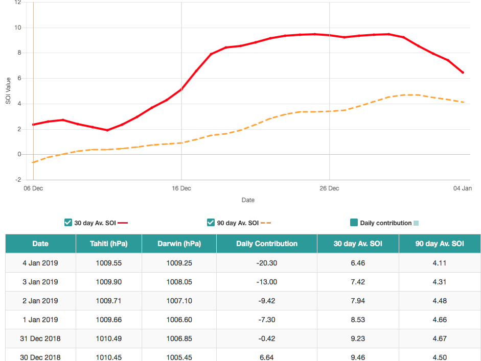
I was really starting to personally be concerned about losing all of January the way things had been looking the last couple days in the long range even though I remained somewhat patient that we would round some kind of corner soon to hone in on when this much needed pattern change might start growing some legs. Salvaging the last half of the month in our region is still doable IMO.