

MAG5035
-
Posts
5,884 -
Joined
-
Last visited
Content Type
Profiles
Blogs
Forums
American Weather
Media Demo
Store
Gallery
Posts posted by MAG5035
-
-
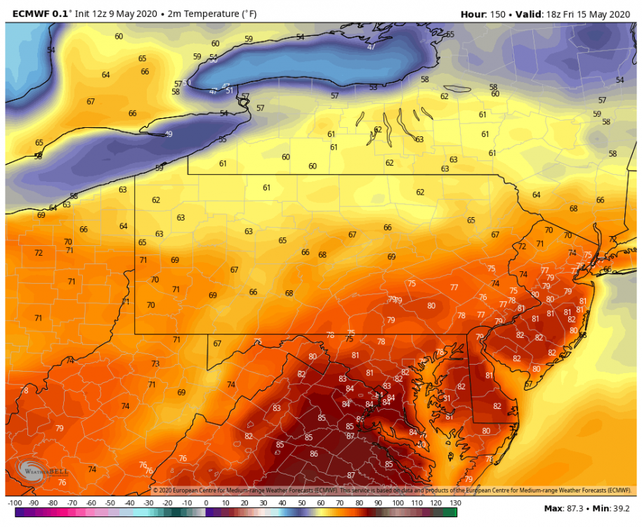
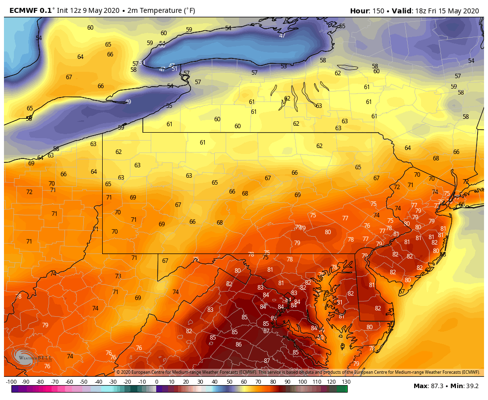
While there's some rain around that could screw this up, this is what we're potentially looking at for highs this coming Friday currently. There's going to be a few more cold nights to get thru the first half of this week though.
-
These heavier squalls moving through the central counties right now are probably going to make it to Harrisburg and deeper into the LSV the next couple hours with the best daytime heating likely maintaining them. Look for them to have grapuel and snow pellets in them as well with the sun heating surface temps into the 40s.
-
 1
1
-
-
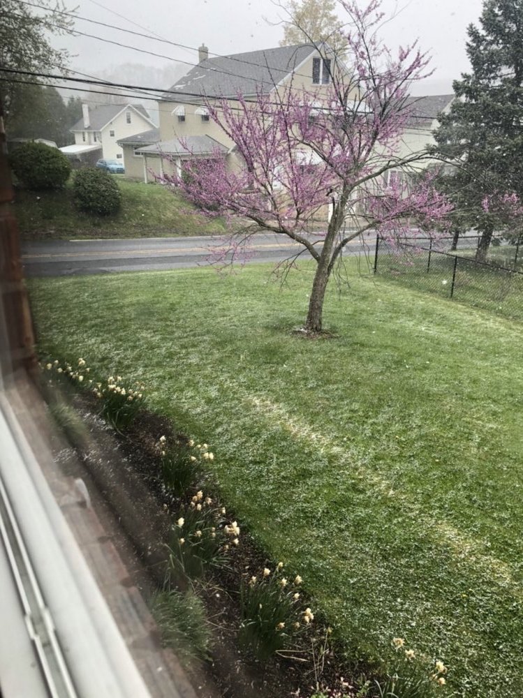
Amazing to see a full fledged snow squall briefly whiten the ground at 1 in the afternoon on May 9th.

-
1
-
-
6 minutes ago, Ericjcrash said:
Its cruel isn't it. I dropped from 39 to 32 almosy literally instantly with the changeover though but I'm way north and at 2000'
Speaking of cruel, the deck and the car tops are already froze over here. That's going to be a long time we're below freezing here (probably 10-12hrs).
-
31 minutes ago, Blizzard of 93 said:
Anyway, how are we looking with the advance of the snow line to the south & east ?
I'd say judging by the radar your currently at your best opportunity to see a mix or changeover with the remaining synoptic precip.
-
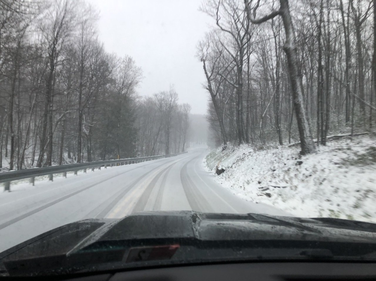
The situation 4 miles away at about 2500’. It’s 29°F up there. Looked like about an inch or so.

-
4
-
-
A steady light to moderate snow driven sideways on a stiff wind, no accumulation. It's definitely a weird sight with the freshly leafed out trees in town here as a backdrop. Temp already back to 35.
-
1 minute ago, Blizzard of 93 said:
Congrats, what do you think of the chances this evening for the LSV?
The 18z 3k NAM still likes the idea of a changeover to snow for most of us by later tonight.
Might see some flakes in parts of the LSV but I think the NW flow drawing the cold into PA and undercutting the back side of the precip shield is going to limit seeing too much east of the mountains because of the downsloping component. Although the surface low getting going on the coast may help a bit keeping some precip around.
-
1 minute ago, Cashtown_Coop said:
Great image there. Is this the gr2 analysts radar ?
Nope this is just the Radarscope app. It's a one time $9.99 app but it's def worth it. It has all the dual pol products, different tilts, shows mPing obs, watch/warning products, etc.
It also has additional subscription tiers now that you can get lightning data, archived and longer radar loops, spc outlooks, and local storm reports on as well. I just have the base one and use it on my phone and laptop.
-
1
-
-
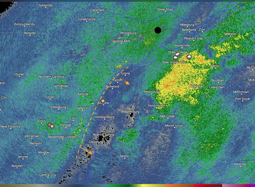
Here's the downslope shadow on the radar, the dashed line is roughly where the Allegheny Front is. The mPing snow report in Altoona is mine. I'll probably eventually make a drive up to the top of the mountain this evening.
-
1
-
 2
2
-
-
5 minutes ago, Bubbler86 said:
Yea, I truly feel bad for the folks out your way that used the Pandemic time to get a head start on their garden and yard stuff. Its not fair really. Even here we may lose a lot of stuff we have worked on but mid 20's is going to hammer stuff out there.
My mom was going to get flowers last weekend and decided not to go that day. I promptly told her she better wait til after Mother's Day.
-
1
-
-
Annd we have flipped to snow here... that quick. It's light though, the downsloping just off the Laurels is evident on the radar.
-
3 minutes ago, Voyager said:
Pretty dramatic change. An hour ago it looked like just rain up there.
Black ice is a definite threat later this evening with the gusty winds and the rapid temp drops, especially in the central counties but everyones probably going under 32 tonight. It's looking to bottom out at 25ºF here, which is really going to hurt sensitive stuff.
-
Snow reports on the mPing obs down into Cambria County now, snow on the ground on the 511pa cam on top of the mountain above Clearfield (I-80 Exit 111). That temp drop in western PA is pretty wild to see. Already freezing in Dubois and Pittsburgh metro is in the mid 30s.
Still rain here but the winds have kicked up pretty good so temps are likely to start falling soon.
-
3 hours ago, Bubbler86 said:
So June 4th is now our next day to look forward to....those in the red.
It’s kind of misleading they announced that when they’re set to announce the next batch of counties today that will be going to yellow. And the way the news sources titled it, it’s really misleading.
I guess I didn’t realize the previous state-wide stay at home was to expire today. They’re basically extending that out for the red counties but they will still be evaluating counties that can move to yellow. There’s not really any change from how they’re running their phased reopening plan, which looks to be evaluating counties on a weekly basis.
-
2 hours ago, Blizzard of 93 said:
What are your thoughts for any chance for CTP snow tomorrow night & Saturday?
The synoptic event def doesn't look as good as it did. The system's timing overall is a bit faster by about 3-6 hours and the low seems a tad north and a bit later with getting going. Pretty much the snowy NAM is looking more like what the Euro has been looking like as the Euro has been the least enthused with wintry precip in PA. Also haven't seen an overly strong signal on ensembles other than maybe the SREF. So I think the changeover to snow is looking like it's going to stay confined to higher ground. It's still going to be crazy cold first thing Saturday morning and still a chance of some pop up frozen showers in the afternoon.
-
10 minutes ago, Wmsptwx said:
Kinda strung out not what’s needed for snow in May lol. Is this going to kill chances of squalls Saturday? If so hoping for a miss lol.
I dunno if it's really all that strung out, the NAM looks like it's coming more into line with what the other models have been showing... having a bigger portion of the event rain especially outside of the high ground. Timing is important with this. If this stays slow enough, the main part of the event is late in the day into at least the first half of the night... taking away the sun part of the equation. You would need crazy rates in the middle of the day this time of the year, but toward dusk (after 18z) and nighttime you can start accumulating with more modest rates. We have the things on the playing field to make this happen, having such a cold airmass pressing in with this storm system passing under us. It's going to be interesting to see what happens. I definitely think the high ground is going to see at least a few inches, but the wild card is going to be if this actually gets to lower elevations or even the Sus Valley.
This won't affect potential for showers/squalls on Saturday. The core of the mid-level cold will either directly target PA or pass just north depending on models on Saturday behind the system. GFS and NAM are taking it right through PA with sub 516 thicknesses.. which is insane. -40ºC 500 mb temperatures are generally not something seen over the US in May. PA gets into -20 to -22ºC temps at 700mb (10,000ft) and -10ºC 850 temps. Even the 925mb temps are well below freezing. I bet some of the higher Laurels and north central elevations never get above freezing during the day Saturday. But you put that really strong May sun and heat the surface with such cold air aloft and your going to get some stuff to pop up.
-
1
-
-
4 hours ago, Bubbler86 said:
LOL, I was just having fun but what if it snows in July? I wonder if they count then in 20-21. LOL.
Anything frozen would go over to the 20-21 season after July 1st. To properly tally average annual snowfall, it's done over a 12 month period from July 1-June 30/31 so the annual snowfall total covers only one actual winter season.
-
4 hours ago, Bubbler86 said:
I would be pissed if my closest PA station, MDT, got enough snow to get over the total for making this the least snowiest winter ever. We are in May now and I want to keep that distinction and not have it blown on a May 3-5"" slopfest miracle.
I once thought as you do. Those last two winters I've tallied snow here in my signature at 54.6" and 52.2" are average winters at my location at the foot of the Laurels. The 16.2" is pretty much 30% of normal and the wall to wall futility was something i've never seen. I was completely over this winter by the beginning of March from a hitting the slopes standpoint as there was never a point this winter the local resorts had a period of even half decent conditions. But you know what? I'm all in on this possible debacle Friday night. It's not likely anything else going on right now is "normal" anyways lol. Plus a paste bomb may actually help insulate the vegetation some with low temps Sat morning in hard freeze territory (mid 20s) Sat morning back this way.
1 hour ago, Itstrainingtime said:In Lancaster' record books, 1982 saw 2.5" accumulate on April 20th. Going back to 1926 that stands as the latest official snowfall in Lancaster.
Having a trace and having measurable are two different things. If the flakes are flyin in the air, that's a T for the day. Grapuel also counts as frozen precip too so a non or little accumulating grapuel shower would go down as a T as well... and that's definitely on the table Saturday in the LSV. Lancaster has probably never had a recorded measurable event in May but that 1977 event for instance may have given them at T. Either way, any frozen that deep into the LSV in May is extremely rare.
I dunno if State College has anything like this but NWS Pittsburgh has a whole webpage of miscellaneous snowfall data for PIT going back to 1884. Their latest recorded snow was May 31, 1893 (T) and latest accumulation of snow was 0.5" on May 25, 1925.
-
Rain and mangled flakes currently.
-
12 minutes ago, Old Bones said:
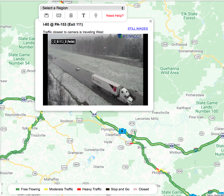
Moderate snow in Rockton Area this morning.
.I was just about to comment that I saw it falling on the 511pa camera at the Penfield/153 exit up there.
-
Lol 0z NAM doesn't have the really heavy amounts but it snows on the whole Sus Valley and gets flakes down to the I-95 corridor in central VA.
-
12 minutes ago, Bubbler86 said:
Does anyone know of definitive records for standard stations as to the latest accumulating snow?
I'm not sure on definitive dates. I would imagine more stations than you might think have recorded a T in May, but as far as measurable? Aside from likely KJST and KBFD I don't know offhand who else. Any measurable more than a trace in the LSV is likely uncharted territory in at least the last several decades.
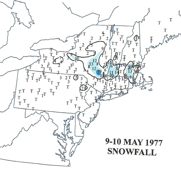
As far as may snowstorms, May 9-10, 1977 apparently had one in Upstate New York and southern New England.
-
2 hours ago, Wmsptwx said:
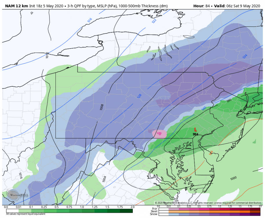
Shouldn’t there be more precip on those models considering placement of 992 low?
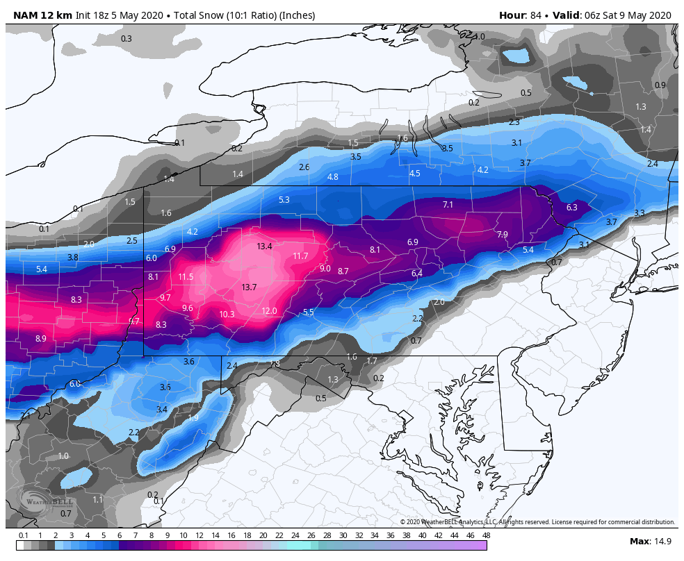
Hah 18z NAM must think so. That's not even done at 84 hours. Welcome to happy hour in May I guess.


Central PA - Spring 2020
in Upstate New York/Pennsylvania
Posted
Looking over the stations that CTP gave numbers for record minimum highs on.. MDT at 46ºF beat theirs by two degrees, Altoona by 1 (40ºF), and IPT (46ºF) and Bradford (34ºF) tied their record values. Browsing the Laurel's stations on the mesowest site, JST and a couple of the stations reporting in Cambria/Somerset barely got above freezing... while a few stations in the Laurel Ridge area near Seven Spring's did not go above freezing at all.
What's really amazing about these min/max temps is the fact that it was achieved on a day that had a fair amount of sunshine in between the clouds/snow showers. Just shows how cold the airmass was. And it even ended up that the core of the 500 low and -40º 500mb temps did in fact only swing through upstate New York/southern New England (hat tip to the Euro).