hlcater
-
Posts
2,686 -
Joined
-
Last visited
Content Type
Profiles
Blogs
Forums
American Weather
Media Demo
Store
Gallery
Everything posted by hlcater
-
I’m pretty bullish on this one relatively speaking so went ahead and made a thread.
-
About time for this one. Models are already fairly robust with 92L with the majority reaching hurricane strength and a good chunk with major status. Environment through D4 is just about as good as it gets, so the intensity ceiling is probably quite high on this one relatively speaking. Cool water, shear and dry air should ensure weakening by landfall at least.
-
92L looks mildly interesting in the medium term. Should have a nice anticyclone/outflow pattern... in the W carib in October.
-
Probably gonna be a big winter for tornadoes and severe weather across the SE.
-
lives were SAVED on 3/28
-
the 2020 severe season started and ended in 45 minutes. 4/7 was okay locally, and 5/23 was fair. But the census for this season yields 2 mediocre severe events, and one exceptional one. I'd honestly trade the derecho for more/better tornado days than we had this year.
-
zzzzzzzzzzzzzzzzzzzzzzzzzzzzzzzzzzzzzzzzzzzzzzzzzzzzzzzzzzzzzzzzzzzzzz
-
Food for thought. I wonder if the dry air in vicinity is actually helping the current convective burst by allowing for steeper lapse rates (on the order of ~6.5c/km), much steeper than the typical 5s you'd expect in a moist neutral profile. More robust updrafts in the short term yielding a better radar configuration than you'd otherwise expect given IR appearance and environment??? That said, that same dry air almost certainly brings this to an end fairly soon here.
-
Looks intriguing, but environment as a whole is still rather unfavorable, so I have my doubts that this feature will have any meaningful persistence. It'll be very easily disrupted.
-
some mad girth on that one
-
Sure. When there was no radar you’d 100% miss that radar signature
-
if nothing else, they've got it named now and can lengthen the path in post if necessary.
-
lol
-
I think that's probably our window for real storm. There will be a period of strong shear and poorly favorable conditions starting late tomorrow and persisting through the weekend. Flow is a bit better aligned as this thing turns around and heads east.
-
The environment down the line for this one is not especially conducive. While models do show development, I’ll be surprised if this becomes more than a minimal cane. Fropa in a few days will introduce dry, stable air into the area in association with 20-30kts of shear.
-
All you need to do to know what that is like is spend a winter in Iceland/Svalbard or the Bering coastline in AK.
-
It is the Iowa derecho. Makes sandy look like child’s play. Not too often when you get a “category 4 inland hurricane”!
-
What a storm.
-
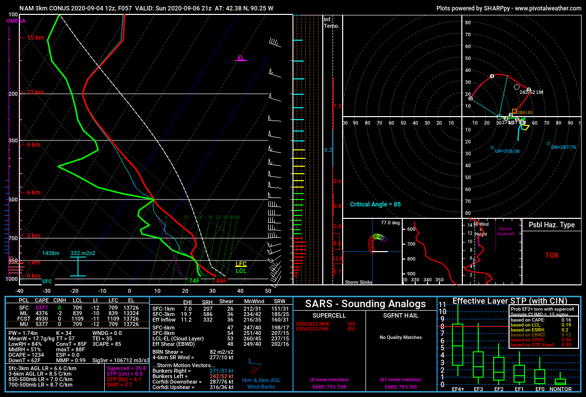
Imagine wasting hodographs like these because 700mb temps are 2 degrees too warm.
-
I wish it was. At least then we wouldn’t be having this discussion.
-
Imagine a good chunk of Iowa developing D3 drought and then receiving 5+ inches of rain in like 3-4 days.
-
DOA
-
The thermal ridge at 700mb is going to be too strong. It will initate, but after dark and along the CF.
-
The T/Td intersection below the EML is cloud cover, and one of the reasons why I’m not at all confident in initiation. That and the stout EML above it are extremely problematic. Regarding the hodograph, veered flow probably isn’t an issue here as the flow aloft is NWly and the resulting hodograph is quite tasty imo. I don’t have many concerns about the parameter space not being able to support a severe/tornado threat. For me, it’s more of what is the chance we get a robust updraft?
-
Some models either do initiate or become extremely close to initiating a storm in this environment. E IA/N IL. I still don’t like EML strength(14c 700s) and subsidence in IA. But far E IA and IL might have a chance....