ma blizzard
-
Posts
3,051 -
Joined
-
Last visited
Content Type
Profiles
Blogs
Forums
American Weather
Media Demo
Store
Gallery
Everything posted by ma blizzard
-
sun / mon night gonna be brutal around KBOS Wouldn't be surprised if Sunday night ends up slightly warmer then Monday night in this area. I'm seeing more of W / WSW component to the surface flow Sun night compared to SW Mon night. Looking back at last weekend, the southerly component overnight def cooled this area off more than I would have expected during the nights. Either way looking at mins in the U70s - L80s
-
how long in the sun? I’ve never seen anything like that before ..
-
ORH up to 91/65, impressive
-
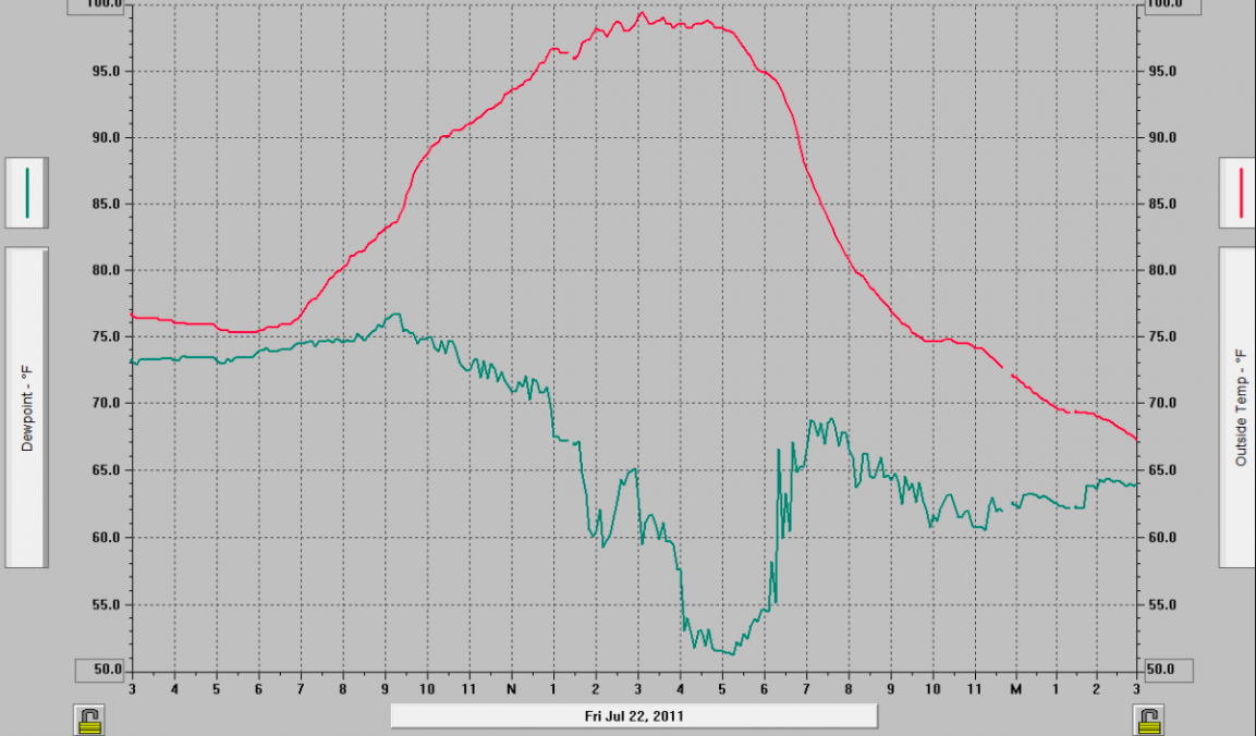
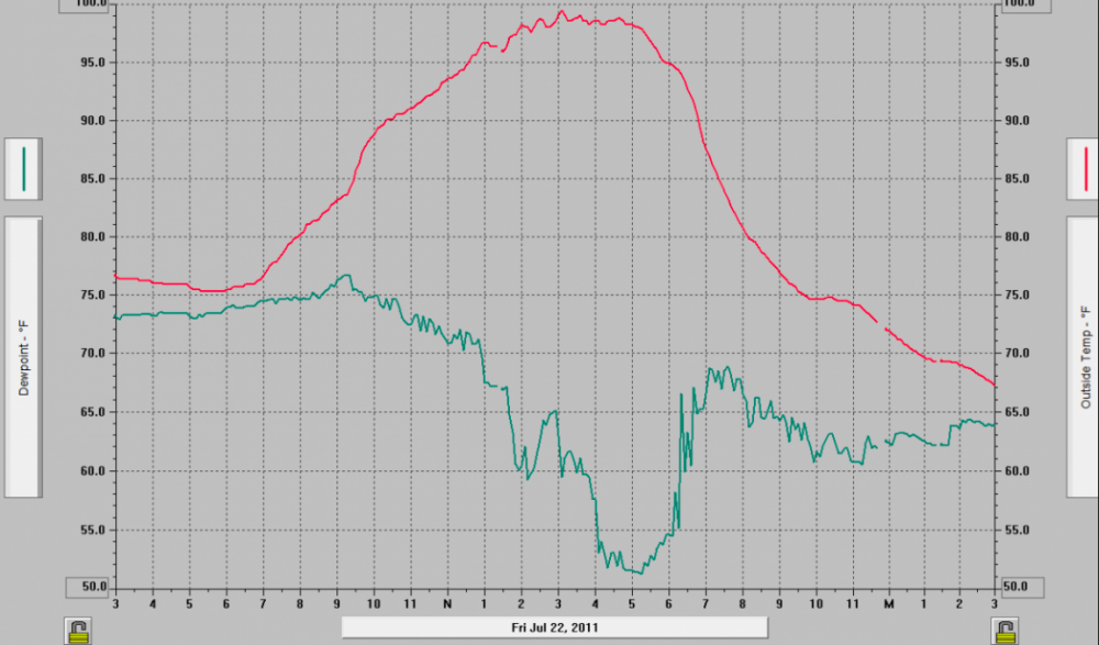
7/22/11 is great example of this! Data from my old Davis back home in Shrewsbury that day: you can see the temp starting to level off a bit at 96 around 1 pm with dews in the low 70s. dews mix out into the low 50s and you get that last 3-4 degree rise .. I believe max was 99.5 and by far the hottest temp I recorded there (since 2006)
-
orh was 86/55 earlier, it didnt just mix out in the valley lol
-
for 100 id wanna see no cloud contamination, high launching pad to start, if possible move the plume of 20-21 c 850 temps in earlier, and more of a west component wrt wind direction. even then you are counting on mixing to like 825-800 mb ish?
-
agreed, but maybe not a big under? I do think there will be a boundary ( ssw vs wsw flow) like that shown in that depiction that seperates MU 90s and dews in the low 60s and 90ish and dews around 70. Maybe bdl or ash could make a run at 100, but as of now id take the under by a hair. would need everything to go “right” but its in play imo
-
DIT closest career comp is prob Adam Dunn
-
TS Fay - Drought ending Rains and Severe Convection
ma blizzard replied to weatherwiz's topic in New England
I have a hard time believing Fay gets yanked hard left like that IMO we see Fay hug the coast before landfall east of NYC on LI -
a little rotation on the cell passing east of KFIT? looks like a good light show incoming for Boston area
-
toasty run on the Euro, heatwave potential next week?
-
May 8-9 mid-spring rain, snow, cold, wind obs
ma blizzard replied to CT Valley Snowman's topic in New England
happens every May KBGM 091953Z 30011G26KT 1/4SM SN FZFG SCT015 BKN023 OVC049 M02/M04 A2984 RMK AO2 PK WND 28028/1926 SNE04B37 SLP124 P0000 T10221044 RVRNO -
ORH: Big time gradient between BOS / ORH
-
-
March 12/13/14 Blizzard/Winter Storm/WWA etc
ma blizzard replied to Bostonseminole's topic in New England
28.9/27 s- 2.7" new since 4:15 pm .. total is up to 21.9" while snow depth (just from this storm) is closer to 18"-19" -
March 12/13/14 Blizzard/Winter Storm/WWA etc
ma blizzard replied to Bostonseminole's topic in New England
yeah not sure why the reports are so low in the PNS .. in the 13"-15" range in the area. As it is, my depth from just this storm is ~16"-17". -
March 12/13/14 Blizzard/Winter Storm/WWA etc
ma blizzard replied to Bostonseminole's topic in New England
29.2/28 S+ 13.4" since 10 am - total is up to 19.2" -
March 12/13/14 Blizzard/Winter Storm/WWA etc
ma blizzard replied to Bostonseminole's topic in New England
if this band persists for another hr, I'll be over 20" for sure -
March 12/13/14 Blizzard/Winter Storm/WWA etc
ma blizzard replied to Bostonseminole's topic in New England
kind of surprised at the snowfall rates considering the visibility isn't that low .. I guess the snow really stacks up when you have ideal snow growth prob the best / most consistent snowfall rates since Jan '15 .. its been at constant 2-3" / hr since about 11:45 -
March 12/13/14 Blizzard/Winter Storm/WWA etc
ma blizzard replied to Bostonseminole's topic in New England
28.4/27 9.2" new since 10 am, ~3.5" in the past 70 mins total is up to 15.1" -
March 12/13/14 Blizzard/Winter Storm/WWA etc
ma blizzard replied to Bostonseminole's topic in New England
6.1" new since 10 am up to 11.9" -
March 12/13/14 Blizzard/Winter Storm/WWA etc
ma blizzard replied to Bostonseminole's topic in New England
27.7/26 absolutely nuking outside .. must be 2"-3" + / hr rates -
March 12/13/14 Blizzard/Winter Storm/WWA etc
ma blizzard replied to Bostonseminole's topic in New England
29.5/28 5.8" stuck in the subsidence in-between bands now .. was ripping between 9-9:45 -
March 12/13/14 Blizzard/Winter Storm/WWA etc
ma blizzard replied to Bostonseminole's topic in New England
32.8 / 30 light snow, coating so far -
yeah some of the parameters look really good .. maybe some of those to the north will have better luck