ma blizzard
-
Posts
3,033 -
Joined
-
Last visited
Content Type
Profiles
Blogs
Forums
American Weather
Media Demo
Store
Gallery
Everything posted by ma blizzard
-
"frigid weather"
-
December 2021 Obs/Disco...Dreaming of a White-Weenie Xmas
ma blizzard replied to 40/70 Benchmark's topic in New England
well i'm sure its going to be wrong haha -
December 2021 Obs/Disco...Dreaming of a White-Weenie Xmas
ma blizzard replied to 40/70 Benchmark's topic in New England
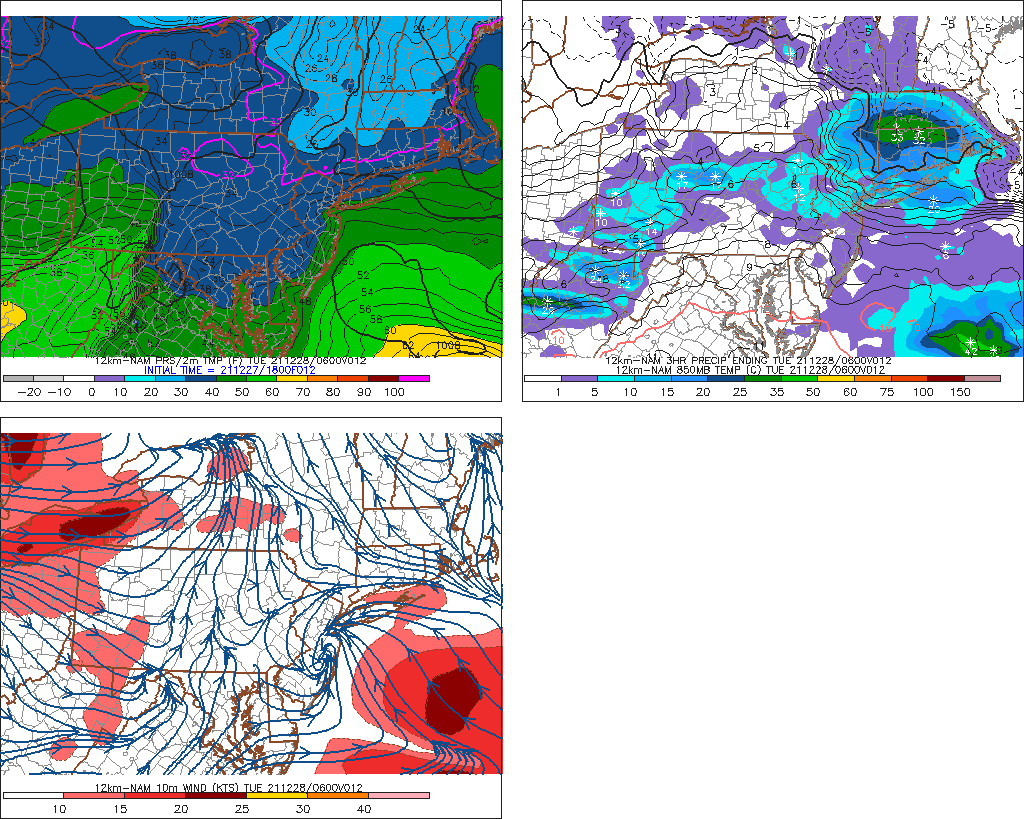
what is the 18z NAM doing .. this is a 12h prog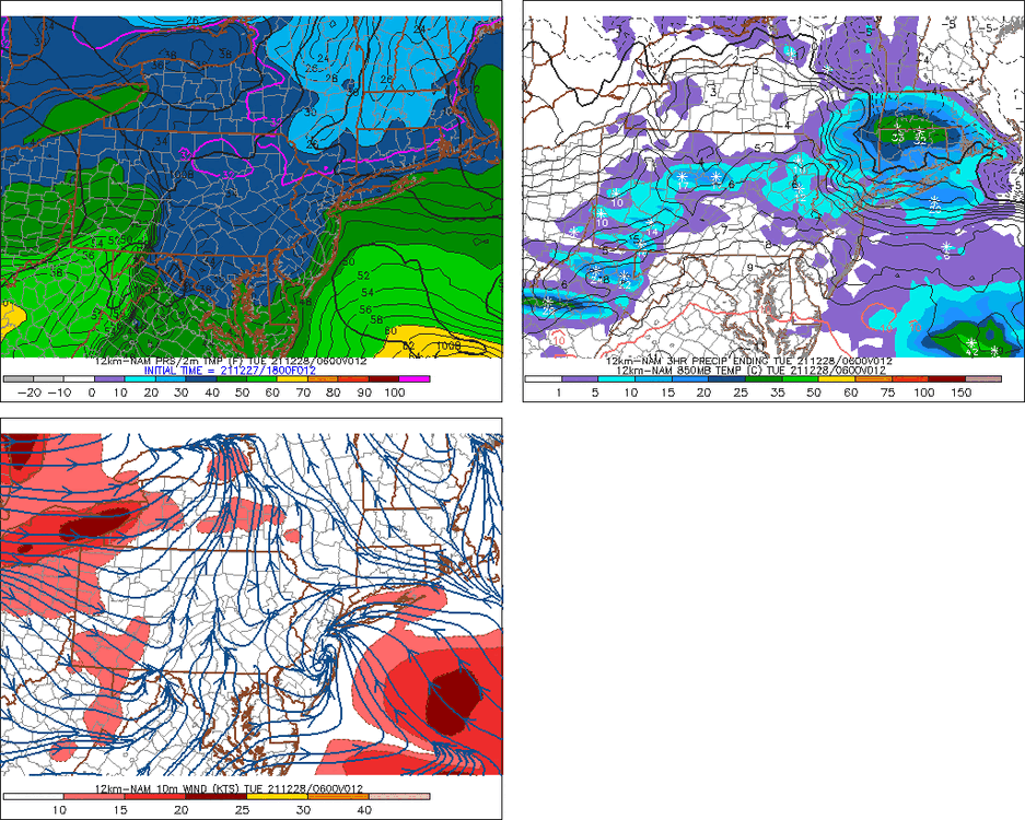
-
December 2021 Obs/Disco...Dreaming of a White-Weenie Xmas
ma blizzard replied to 40/70 Benchmark's topic in New England
pretty sure forky posted an 850 mb temp anomaly map? -
verbatim GFS looks like 1"-3" N MA / S NH tonight
-
RGEM and CMC have been noticeably colder than other guidance with 2m temps every run for tomorrow .. anyone know if they did something to those models
-
December 2021 Obs/Disco...Dreaming of a White-Weenie Xmas
ma blizzard replied to 40/70 Benchmark's topic in New England
We'll see might be more ice than cold rain for you .. either way its marginal so probably nbd regardless -
December 2021 Obs/Disco...Dreaming of a White-Weenie Xmas
ma blizzard replied to 40/70 Benchmark's topic in New England
yeah 3km NAM quite impressive with how it keeps the low lvl cold air locked in.. weak SLP along the south coast reinforces the northerly drain in the afternoon. Not a lot of QPF and marginal temps, but still thats the coldest run I've seen yet. -
December 2021 Obs/Disco...Dreaming of a White-Weenie Xmas
ma blizzard replied to 40/70 Benchmark's topic in New England
3 km NAM and 0z HRRR looking icy xmas day -
we cold tuck looks like Boston metro even gets below freezing within a couple hrs
-
-
enjoy the zr
-
December 2021 Obs/Disco...Dreaming of a White-Weenie Xmas
ma blizzard replied to 40/70 Benchmark's topic in New England
PAC NW can do volcanoes too -
December 2021 Obs/Disco...Dreaming of a White-Weenie Xmas
ma blizzard replied to 40/70 Benchmark's topic in New England
12/16/73 -
Wednesday 12/8 Possible Snow/Ice/Rain? Discussion
ma blizzard replied to Torch Tiger's topic in New England
18z NAM H5 looks a tic more amped / tucked in compared to 12z -
Wednesday 12/8 Possible Snow/Ice/Rain? Discussion
ma blizzard replied to Torch Tiger's topic in New England
this place is like an insane asylum .. and its only 12/5 -
1921 repeat would make 08 look like a walk in the park
-
Potential Major Noreaster 10-26 through 10-27
ma blizzard replied to ineedsnow's topic in New England
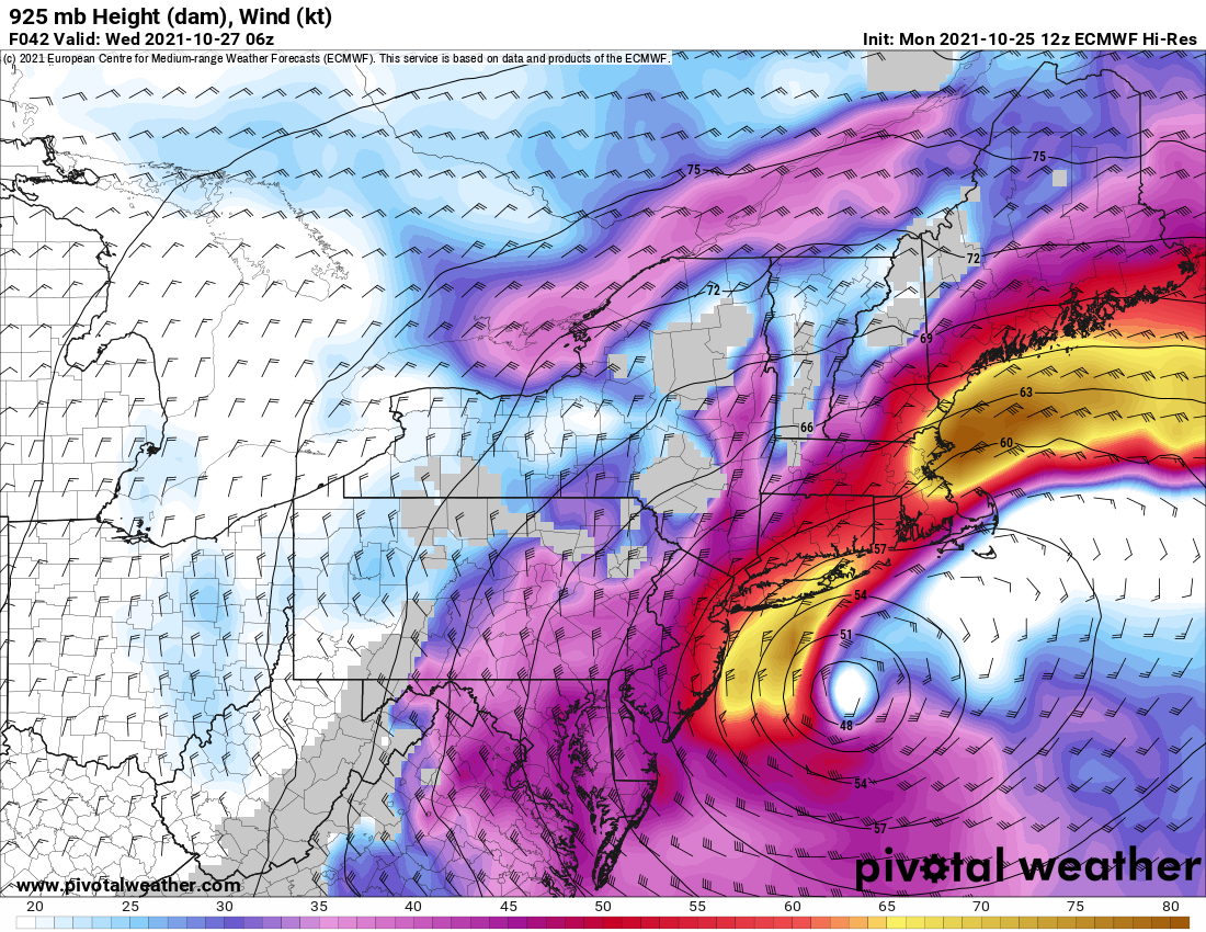
3km NAM tracks this between the Cape and ACK .. might be the most zoinked run yet -
Potential Major Noreaster 10-26 through 10-27
ma blizzard replied to ineedsnow's topic in New England
you are not wrong, almost goes over ACK -
Potential Major Noreaster 10-26 through 10-27
ma blizzard replied to ineedsnow's topic in New England
maybe ORH if that meso low really gets slung back inland it’s unlikely -
Potential Major Noreaster 10-26 through 10-27
ma blizzard replied to ineedsnow's topic in New England
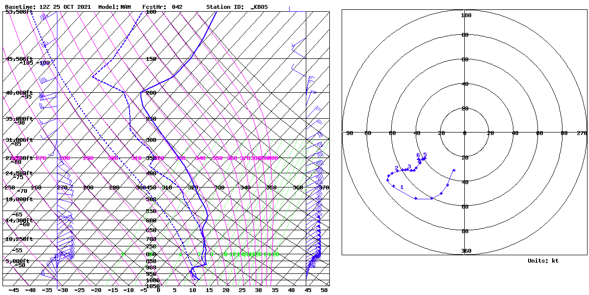
75-80+ kt at 925 .. impressive
-
Potential Major Noreaster 10-26 through 10-27
ma blizzard replied to ineedsnow's topic in New England
kinda surprised there isn't more of an inversion .. should be fun on the coast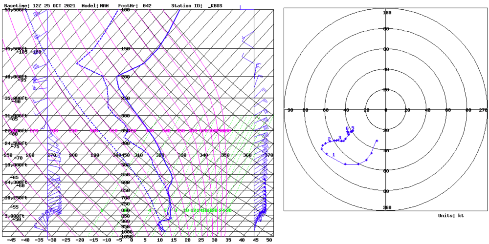
-
October Discussion: Bring the Frost-Hold the Snow
ma blizzard replied to 40/70 Benchmark's topic in New England
For KBOS past 30ish years: 10/10/2018 86 10/9/2011 87 10/10/2011 85 10/4/2007 86 10/2/2002 85 10/6/1990 86 10/7/1990 85 90 after 10/1: 10/7/1963 (3 days 85+, including 86 on 10/27 - latest 85+ on record) 10/12/1954 (4 days 85+ this month) 10/1/1881 -
October Discussion: Bring the Frost-Hold the Snow
ma blizzard replied to 40/70 Benchmark's topic in New England
riveting discussion