ma blizzard
-
Posts
2,869 -
Joined
-
Last visited
Content Type
Profiles
Blogs
Forums
American Weather
Media Demo
Store
Gallery
Everything posted by ma blizzard
-
-
enjoy the zr
-
December 2021 Obs/Disco...Dreaming of a White-Weenie Xmas
ma blizzard replied to 40/70 Benchmark's topic in New England
PAC NW can do volcanoes too -
December 2021 Obs/Disco...Dreaming of a White-Weenie Xmas
ma blizzard replied to 40/70 Benchmark's topic in New England
12/16/73 -
Wednesday 12/8 Possible Snow/Ice/Rain? Discussion
ma blizzard replied to Torch Tiger's topic in New England
18z NAM H5 looks a tic more amped / tucked in compared to 12z -
Wednesday 12/8 Possible Snow/Ice/Rain? Discussion
ma blizzard replied to Torch Tiger's topic in New England
this place is like an insane asylum .. and its only 12/5 -
1921 repeat would make 08 look like a walk in the park
-
Potential Major Noreaster 10-26 through 10-27
ma blizzard replied to ineedsnow's topic in New England
3km NAM tracks this between the Cape and ACK .. might be the most zoinked run yet -
Potential Major Noreaster 10-26 through 10-27
ma blizzard replied to ineedsnow's topic in New England
you are not wrong, almost goes over ACK -
Potential Major Noreaster 10-26 through 10-27
ma blizzard replied to ineedsnow's topic in New England
maybe ORH if that meso low really gets slung back inland it’s unlikely -
Potential Major Noreaster 10-26 through 10-27
ma blizzard replied to ineedsnow's topic in New England
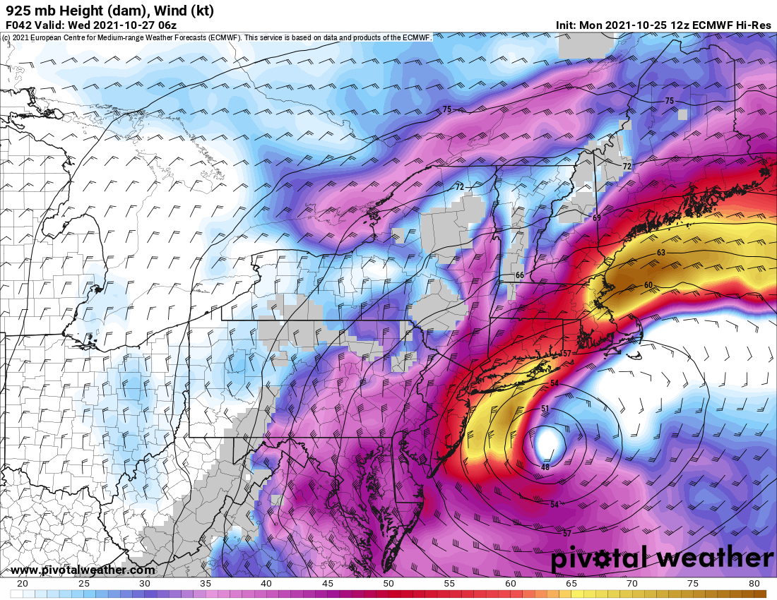
75-80+ kt at 925 .. impressive
-
Potential Major Noreaster 10-26 through 10-27
ma blizzard replied to ineedsnow's topic in New England
kinda surprised there isn't more of an inversion .. should be fun on the coast
-
October Discussion: Bring the Frost-Hold the Snow
ma blizzard replied to 40/70 Benchmark's topic in New England
For KBOS past 30ish years: 10/10/2018 86 10/9/2011 87 10/10/2011 85 10/4/2007 86 10/2/2002 85 10/6/1990 86 10/7/1990 85 90 after 10/1: 10/7/1963 (3 days 85+, including 86 on 10/27 - latest 85+ on record) 10/12/1954 (4 days 85+ this month) 10/1/1881 -
October Discussion: Bring the Frost-Hold the Snow
ma blizzard replied to 40/70 Benchmark's topic in New England
riveting discussion -
same snow cover stats for ORH?
-
September Discussion Thread: Bring the frost; kill the bugs.
ma blizzard replied to moneypitmike's topic in New England
3"-4" of slop in Somerville while like 8 mi away saw 18" infuriating -
September Discussion Thread: Bring the frost; kill the bugs.
ma blizzard replied to moneypitmike's topic in New England
some seasonable and dry weather would be nice as the crop finishes up -
September Discussion Thread: Bring the frost; kill the bugs.
ma blizzard replied to moneypitmike's topic in New England
nah I think their name was Will .. IIRC lives in a big spot now in the upper peninsula of Michigan far away from civilization -
yup 15 years on Eastern / here for me
-
September Discussion Thread: Bring the frost; kill the bugs.
ma blizzard replied to moneypitmike's topic in New England
if october snow is bad, september snow is worse? -
gonna be a close call
-
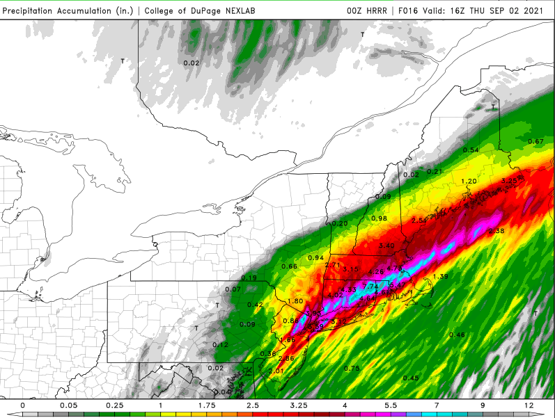
def believable .. convection along the south coast gets lifted to that axis where the crazy totals are depicted.. trains east as the blob by NYC moves ENE along that same axis .. gonna be wild
-
-
-
holy sh!t