

ma blizzard
-
Posts
2,873 -
Joined
-
Last visited
Content Type
Profiles
Blogs
Forums
American Weather
Media Demo
Store
Gallery
Everything posted by ma blizzard
-
98 on 4/19 at KPVD? crazy
-
verbatim it isn’t much , but close to something interesting having said that, Euro is on its own here
-
I agree - EURO is on its own with the D6/D7 thing .. a bias we've seen time and time again for sure I'm more interested with what happens next .. solid signal for a coastal ~D9/10
-
long range EURO looks lovely NNE / mountains prob not done yet
-
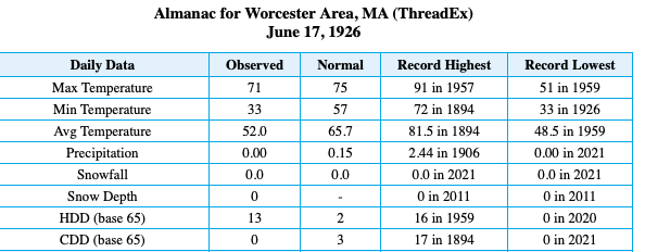
https://www.nytimes.com/1926/06/18/archives/frost-hits-new-england-farm-and-garden-crops-blighted-by.html
-
^ got me looking at some of the first / last dates on the BOX climate page .. how about this for latest 33 on record: Must have been quite the airmass to radiate like that 4 days before the solstice
-
-
Saturday, March 19, 2022 Elevated Convection w/Severe Potential
ma blizzard replied to weatherwiz's topic in New England
12/30/2019 https://www.washingtonpost.com/weather/2019/12/30/only-new-england-an-ice-storm-hail-storm-severe-thunderstorm-all-once/ -
not concerned we see 3rd year la niña?
-
March 2022 Obs/Disc: In Like a Lamb, Out Like a Butterfly
ma blizzard replied to 40/70 Benchmark's topic in New England
no problem tossing Thursday if it means Friday is 70-75 and sunny -
fortran?!?
-
incoming squalls in SE NH look solid
-
big gradient with cold lurking .. could be fun!
-
so true! funny how that changes as we get older
-
0z HRRR looks quite amped
-
enjoy! light snow here
-
solid burst of snow incoming for southeastern sections .. maybe pick up a quick inch
-
when was the last time this happened? seems like its been awhile .. maybe we are due?
-
yea the WRF-ARW / NSSL aren't backing down .. similar to 0z runs from last night gets the sub freezing air to the pike by ~7z
-
a likely progression .. just 5-10 degrees too cold Just wanted to post for a laugh .. although wouldn't surprise me if NE MA / SE NH cooled faster than modeled by the NAM by a couple hours .. not that is matters much
-
DIT model?
-
through 33 surface looks very smilier to 18z .. tick warmer, most noticeable in western areas
-
don't worry, I'm sure the ARW will show something entertaining
-
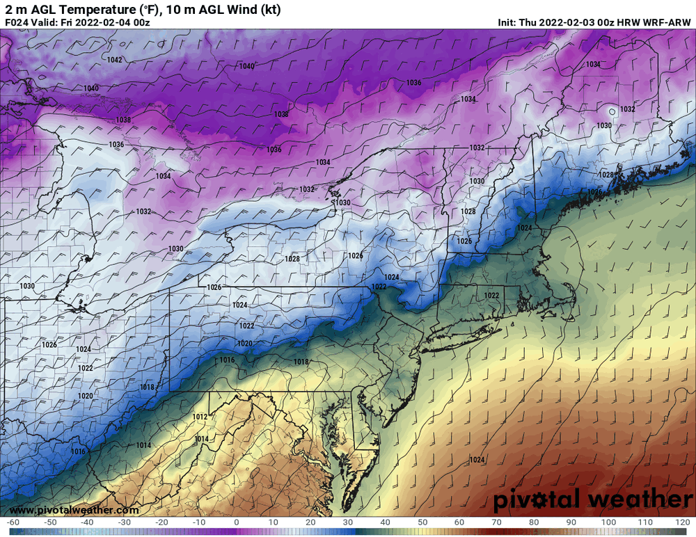
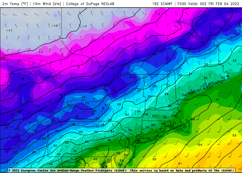
Interesting that the EURO slips the surface boundary south tomorrow evening. Even has a weak Meso low in the gulf of Maine. Unfortunately, the real push of subfreezing air is so delayed, that we just rot in the mid 30s overnight. This would have been a lot more interesting if the initial cold push was better / oriented more E-W instead of SW to NE. And now the 0z HRRR shifts everything 50 miles north
-
watch the ridge off the west coast, thats the key to getting colder solutions IMO


