Wurbus
-
Posts
666 -
Joined
-
Last visited
Content Type
Profiles
Blogs
Forums
American Weather
Media Demo
Store
Gallery
Everything posted by Wurbus
-
March 11th-13th Winter Weather Event. Winter's last gasp?
Wurbus replied to Windspeed's topic in Tennessee Valley
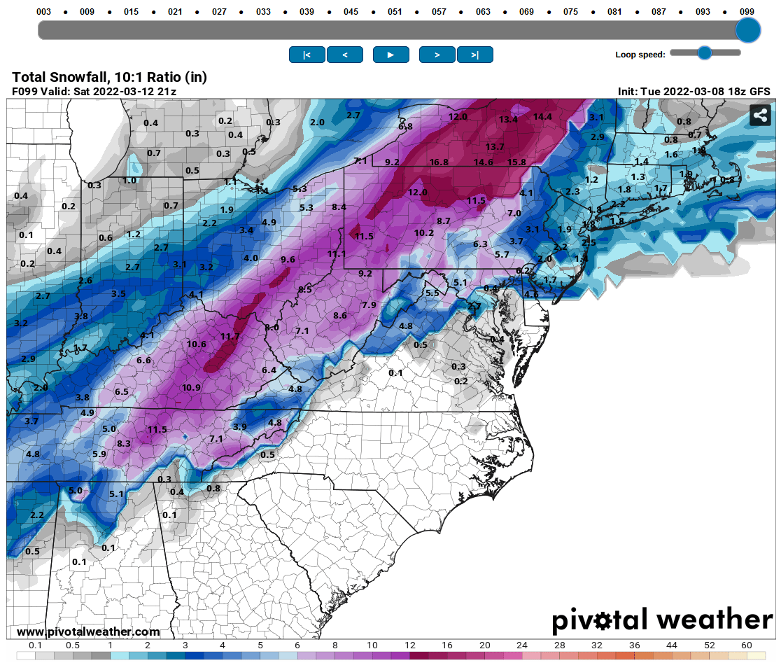
Definitely less big dogs on SREF Plumes. Knoxville went from 2.5" to 1.5" average. -
March 11th-13th Winter Weather Event. Winter's last gasp?
Wurbus replied to Windspeed's topic in Tennessee Valley
Very odd to me they have Athens in the 1-2" range and Knoxville less than .5" -
March 11th-13th Winter Weather Event. Winter's last gasp?
Wurbus replied to Windspeed's topic in Tennessee Valley
12z Nam clown map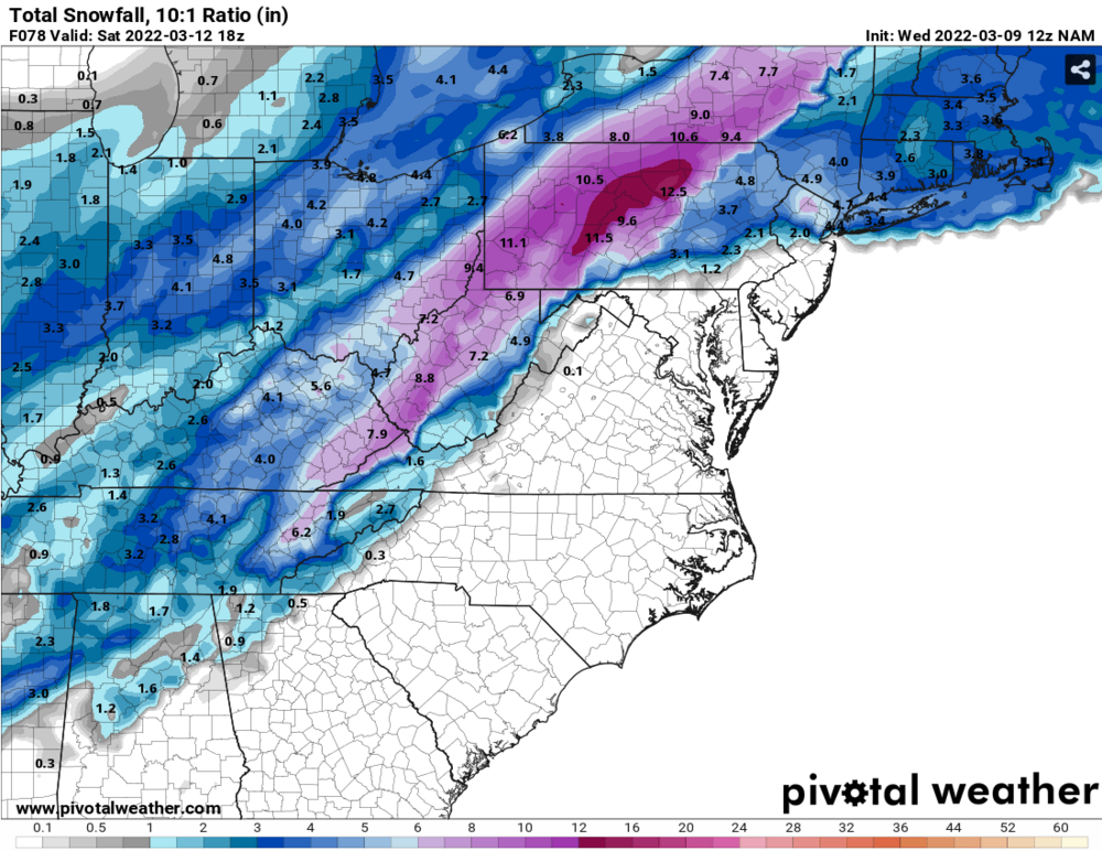
-
March 11th-13th Winter Weather Event. Winter's last gasp?
Wurbus replied to Windspeed's topic in Tennessee Valley
I'll let the experts chime in about keeping it on the other side of the Apps, but it was 4mb stronger that run. I'm all for stronger as long as it stays in NC though! -
March 11th-13th Winter Weather Event. Winter's last gasp?
Wurbus replied to Windspeed's topic in Tennessee Valley
"Warm" dome activated over Nashville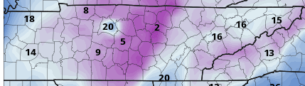
-
March 11th-13th Winter Weather Event. Winter's last gasp?
Wurbus replied to Windspeed's topic in Tennessee Valley
Pretty decent for this time of the year.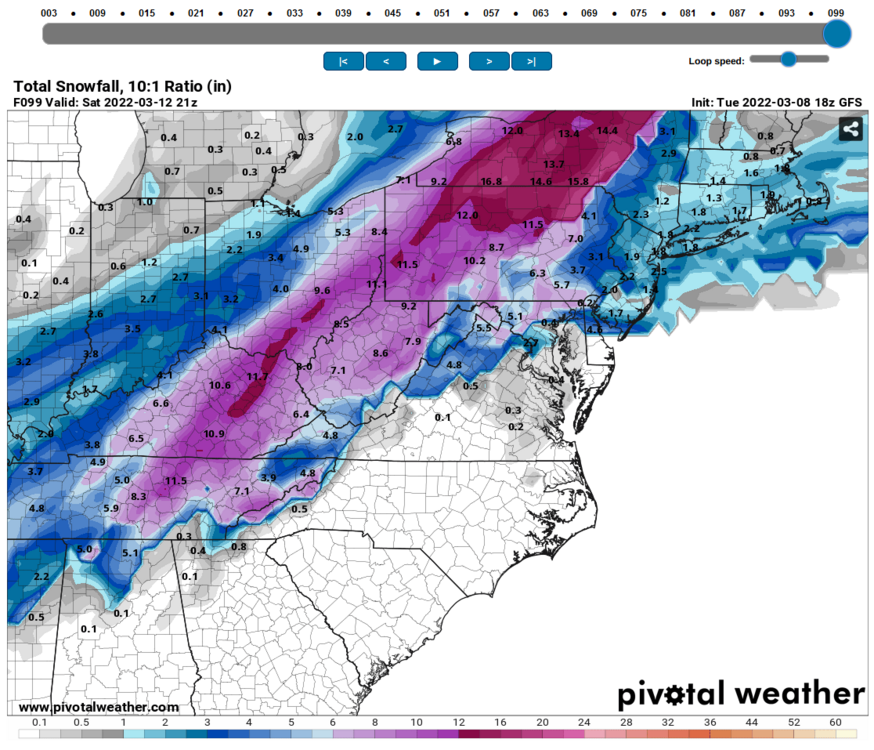
-
March 11th-13th Winter Weather Event. Winter's last gasp?
Wurbus replied to Windspeed's topic in Tennessee Valley
I just switched to the Canada map and it looks like pivotal automatically switches it to cm. -
March 11th-13th Winter Weather Event. Winter's last gasp?
Wurbus replied to Windspeed's topic in Tennessee Valley
Most ensembles look pretty good at 90. Can't attach a screenshot though. -
March 11th-13th Winter Weather Event. Winter's last gasp?
Wurbus replied to Windspeed's topic in Tennessee Valley
Knoxville is the jackpot that run.....don't see that too often. -
-
Sorry, been a crazy busy day and just now catching up on the model runs. I didn't see any huge individual members skewing the mean on the 12/18z runs. Per those GEFS runs, it appears the 15th-17th is a time to watch. That is still 2 weeks out, so take it with a grain of salt.
-
January 28th-29th Clippers/NW Flow Obs/Last Minute Forecasts.
Wurbus replied to John1122's topic in Tennessee Valley
I just started seeing some flurries near Karns. -
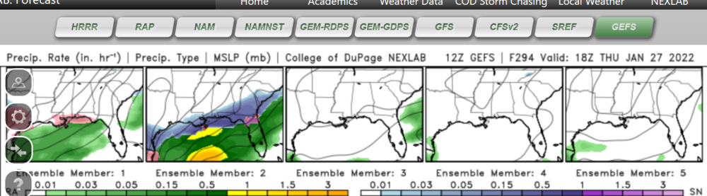
I do like the upcoming potential pattern. With that being said, there was 1 GEFS member that plastered East TN with 24+ inches that is skewing the snow mean I think.
-
Happy Hour lost the storm for next weekend. I'm sure we will see many more fluctuations between now and then. Basically just dry and cold after the front moves through mid-week through 240.
-
Fall/Winter Banter - Football, Basketball, Snowball?
Wurbus replied to John1122's topic in Tennessee Valley
I'm not sure if there was some feedback issue with one member of the 06 GEFS, but weather.us shows 50 inches of snow for one member. I've never seen anything even close to this, so that is why I'm putting it here in Banter. -
Yeah. I had a straight flizzard for about an hour. Wound up with a dusting on everything but the roads.
- 167 replies
-
- 2
-

-
- frost
- cold front
- (and 4 more)
-
They have to measure this on pavement or something.
-
Looks like several members of the EPS had a pretty good snowfall for the system this weekend.
-
I wound up with about 1.5 inches near Karns. I wound up having light to moderate snow from 2-8 yesterday, but it didn't really start sticking until around 4 or so. Have some flurries this morning from the clipper, but not much besides that.
-
Same. Rippin half dollars again.
-
Mixing with rain now here. Those were some pretty heavy rates earlier driving the big flakes coming down.
-
Huge fatties near Karns
-
https://twitter.com/WBIRWeather/status/1482763722439507972?t=3NCS-xn99DGKM9EyXwCMOw&s=19 8 inches at Newfound Gap with winds blowing up to 60mph already.
-
Just catching up on the 12z and 18z models today. Looks like the potential for a great pattern over the next couple weeks. I saw this storm on member 2 of the GEFS, would be really something if the gulf states saw some snow like that, but just shows the potential of the pattern.
-
About the only consistent feature on these models is the warm nose through the valley. Everything else just seems like a crap shoot. I don't envy anyone making these calls.