Runman292
-
Posts
766 -
Joined
-
Last visited
Content Type
Profiles
Blogs
Forums
American Weather
Media Demo
Store
Gallery
Everything posted by Runman292
-
MRX has made it official. The entire state is under a Winter Storm Watch. 3-7 inches mentioned in their watch.
-
Was it that Ben guy?
-
Sleet is better than freezing rain.
-
Just woke up so I probably missed the event. No precip in Oak Ridge. My back road that is never treated isn't slick, so any ice that formed has melted.
-
Anyone in the Nashville area seeing a mix right now?
-
Areas along Interstate 40 and 81 have now been included into the Winter Weather Advisory.
-
RGEM puts a bullseye right on Anderson County. I definitely don't want to see three tenths of an inch of ice.
-
Now that we have advisories in the northern parts of TN, it's as good of a time as any for this thread. MRX: .LONG TERM... (Sunday through Friday) Issued at 340 AM EST Sat Jan 4 2025 Key Messages: 1. A winter storm will affect portions of the area Sunday into Monday. Ice accumulation is expected, mainly north of I-40 and west of I-81. 2. Potential for high winds for the mountains and foothills Sunday night into Monday. 3. Very cold air remains across the region next week. Discussion: Overall, not much has changed regarding the upcoming winter storm that will affect the area on Sunday into Monday. Winter impacts are expected across portions of our forecast area, especially in areas north of I-40 and west of I-81. Icing events are fairly uncommon in our area, unless there is a very cold air mass already in place before precipitation arrives. It appears we will have that setup for this winter event. Strengthening isentropic ascent will produce light precipitation beginning Sunday morning, mainly west of Interstate 75, with precipitation gradually beginning to increase eastward throughout the day. At the onset of precip, very cold, dry air will be in place at the surface. Initially, precip will have a difficult time making it to the surface, and this evaporative cooling will help maintain sub-freezing surface temperatures into the afternoon as precip rates intensify. Temperatures will likely be slow to rise despite warm advection aloft, creating a setup for freezing rain. Models often tend to erode the shallow cold air too quickly in these situations. QPF totals are light Sunday, but even light amounts around 0.1 inch would result in hazardous, icy travel. With the southerly flow, downslope and warming conditions across the western mountain foothills will result in a warm nose west of the mountain chain across the foothills. This means that the highest probabilities of freezing rain ice accumulation greater than 0.1 inch will be north of Interstate 40 and northwest of Interstate 81. The highest ice accumulation is still expected near the Kentucky line and into southwest Virgina, where 0.1 to 0.25 inch of ice accumulation is expected.Temperatures will gradually rise above freezing as warm advection takes over Sunday evening as the surface low move northeast across the Ohio River Valley. By Monday morning, winds shift to the WNW/NW as cold advection begins in the wake of a cold front. Scattered light snow showers are likely on Monday, especially across the higher elevations, as orographic lift enhances snowfall across the mountains. Based on the above, a Winter Weather Advisory will be issued for portions of the Cumberland Plateau and adjacent counties, where confidence is moderate that some ice accumulation will occur, beginning Sunday morning. In the SW VA counties, there will be more of a snow/freezing rain mix that complicates things, and lowers confidence that Warning criteria for ice (1/4 inch) will be met. The 06Z run of the HRRR is showing less ice and more snow for SW VA. With this lower confidence, and the timing of precip onset being mainly Sunday afternoon, the Winter Storm Watch will be maintained there. There is a potential for significant travel impacts on Sunday on I-75 and I-81 in SW VA.
-
Is it a proper time to start up a thread for Sunday?
-
Summer-Fall 2024 Weather Disco Med/Long Range
Runman292 replied to John1122's topic in Tennessee Valley
Apparently, even though we could see Helene as a tropical storm when it moves into TN, the NWS can't issue Tropical products for Tennessee according to MRX.- 688 replies
-
- 1
-

-
- heat
- thunderstorms
- (and 7 more)
-
Tornado Warning for Claiborne and Hancock counties.
-
I wonder how bad the squall line will be overnight with all of these storms moving through right now.
-
In addition, the 10% hatched tornado risk has expanded as far east as Knox County.
-
The rotation stayed just to the south of my house.
-
With the initial storms missing the eastern valley and staying in the northern plateau and Kentucky, will that lead to increased chances for worse storms later in the valley?
-
From MRX:

-
Sun is trying to come out in Oak Ridge. Edit: Sun is fully out now.
-
Will these morning storms weaken the storms later on?
-
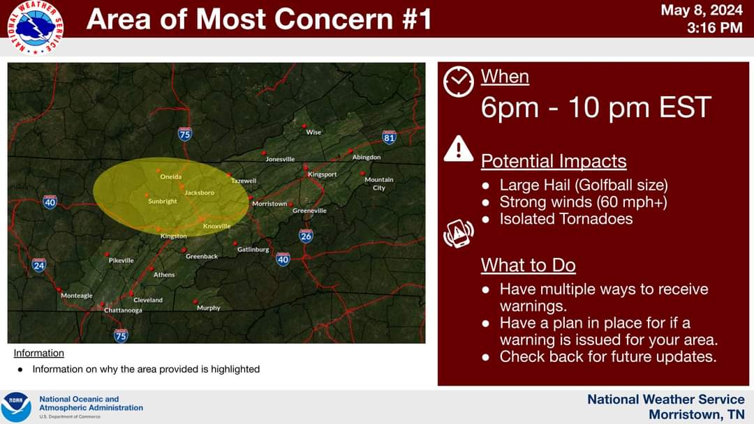
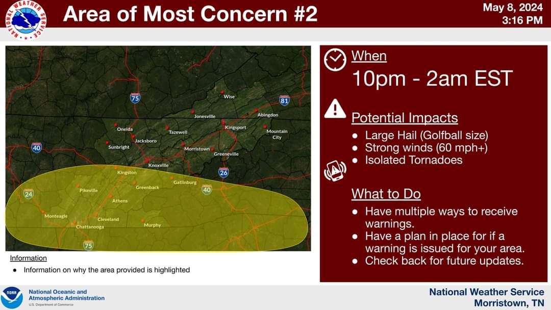
Latest AFD from MRX: .SHORT TERM... (Today and tonight) Issued at 341 AM EDT Wed May 8 2024 Key Messages: 1. A regional severe weather outbreak is increasingly likely from late this afternoon through tonight across the Mississippi River Valley and Tennessee Valley.The threats include widespread damaging winds, very large hail, and tornadoes (including EF-2+ strength). The tornado threat is highest along and west of Interstate 75. 2. Scattered to possibly numerous instances of flooding are likely, especially west of Interstate 75. This threat will be most amplified from this evening to Thursday morning. Today and Tonight Currently early this morning, a 120+ kt 250mb jet extends into the western Great Lakes with a southern jet of near 100 kts extending from the southern Mississippi Valley. A very broad warm sector is also in place with a cold front near the Mississippi River and a warm front near the Great Lakes. Also, strong to severe convection is ongoing across the Ohio River Valley and will continue to progress southward through the morning hours. By daybreak, the aforementioned northern jet will progress towards the eastern Great Lakes with the left-exit region of the southern jet being placed directly over Tennessee and westward. This will create a strongly divergent pattern aloft. The timing of when this initial convection arrives is still somewhat uncertain, but a later timing (early afternoon) would allow for more destabilization beforehand and could slightly limit instability for the evening/overnight period. In any case, deep-layer shear by the early afternoon will reach near or above 40 kts with MLCAPE in excess of 2,000 J/kg. During this time, the flow pattern will still be fairly light and still somewhat uni-directional, but the thermodynamics and overall profiles are still sufficient for storm organization and a damaging wind and hail threat. By the late afternoon through tonight, the wind profile will strengthen and become increasingly more veered with opportunity for additional destabilization beyond 2,500 J/kg of MLCAPE, especially if there is some break in earlier activity. During this timeframe, effective shear is expected to reach or exceed 50 kts with very right-turning hodographs. The CAMs still differ some on the timing and evolution of convection, but most solutions suggest widespread organized supercells by the late afternoon along and north of Interstate 40 with one or more line segments arriving through the evening hours. While the low-level shear isn`t too strong, impressive low-level instability and veering wind direction yield pretty high confidence in STP values to exceed 2 or 3, especially along and west of Interstate 75. In the mid-levels, lapse rates of around 7 Celsius/km or greater can be expected with very impressive CAPE in the -10 to -30 Celsius region of 800 to 1,000 J/kg. While the CAMs differ on exact timing and storm mode, widespread storms are indicated anytime from the afternoon through the overnight hours, initially focused north and then shifting south. The latest HREF data suggest a broad swath of updraft helicity tracks across much of the area and focused especially along and west of Interstate 75. In any case, it should be noted that this system has already produced numerous tornadoes, including some strong to violent, across the Great Plains to places along and north of the Ohio River Valley. This event will also almost certainly continue to the overnight hours, presenting a nocturnal severe weather threat. Another important aspect of this event is duration, intensity, and coverage of convection. Places further south may not see as much coverage during the day, but this will likely occur more from the evening to early Thurday morning. The CAMs are indicating high probabilities for over 3" of rainfall with notable probabilities (20 to 30 percent) for 5" or more of rainfall. Just as with the tornado threat, this is elevated even more further west. Based on the strong signals and likelihood of significant rainfall, a Flood Watch wasissued for the entire area. The threat is certainly not uniform area-wide, but the signals suggest rainfall and antecedent conditions sufficient for scattered to maybe even numerous instances of flooding.
-
30% hatched hail goes all the way east into Knoxville.
-
How can I view the placement of the warm front on models?
-
What would the warm front staying in TN cause?
-
Just about everyone in TN is now in the Enhanced risk for Severe storms tomorrow.

.gif.f872b58d96633aed8e46e26a59283155.gif)