

Eskimo Joe
-
Posts
24,698 -
Joined
-
Last visited
Content Type
Profiles
Blogs
Forums
American Weather
Media Demo
Store
Gallery
Everything posted by Eskimo Joe
-

Thursday 1/20/22 Stat Padder Discussion and Observations
Eskimo Joe replied to stormtracker's topic in Mid Atlantic
-
Thursday 1/20/22 Stat Padder Discussion and Observations
Eskimo Joe replied to stormtracker's topic in Mid Atlantic
Bring it. Then we flash freeze. -
Thursday 1/20/22 Stat Padder Discussion and Observations
Eskimo Joe replied to stormtracker's topic in Mid Atlantic
Still a better win percentage than Aaron Rodgers in the NFC Championship. -
Jan 21 - 22 Weekend SE VA and Eastern Shore Snow
Eskimo Joe replied to stormtracker's topic in Mid Atlantic
-
Jan 21 - 22 Weekend SE VA and Eastern Shore Snow
Eskimo Joe replied to stormtracker's topic in Mid Atlantic
Chincoteague or Cape Charles are the places to be for this. Cape Charles brewing is one of the best breweries I've ever been to. Beer and snow, what more do you need? -
Thursday 1/20/22 Stat Padder Discussion and Observations
Eskimo Joe replied to stormtracker's topic in Mid Atlantic
Looks like we get cold Thursday night, no? -
There's that northern crew spirit. I knew you had it in you.
-
Jan 21 - 22 Weekend SE VA and Eastern Shore Snow
Eskimo Joe replied to stormtracker's topic in Mid Atlantic
-
Jan 21 - 22 Weekend SE VA and Eastern Shore Snow
Eskimo Joe replied to stormtracker's topic in Mid Atlantic
Ratios will be better on the NW side so we'll win. -
Jan 21 - 22 Weekend SE VA and Eastern Shore Snow
Eskimo Joe replied to stormtracker's topic in Mid Atlantic
Other spots worth eating at for Chincoteague: 1.) Lunch (summer): SeaStar Cafe 2.) Dinner, Easter through Christmas (reservations strongly recommended): Etta's Channel Side (great views). -
Jan 21 - 22 Weekend SE VA and Eastern Shore Snow
Eskimo Joe replied to stormtracker's topic in Mid Atlantic
I'd take the 12z Euro for mby in a skinny minute. Lowlanders get snow with no temp issues it seems. -
Jan 21 - 22 Weekend SE VA and Eastern Shore Snow
Eskimo Joe replied to stormtracker's topic in Mid Atlantic
My benchmark is 3" - 5" for this event in Reisterstown. If we get a solid advisory level event on the weekend, with cold air behind it, what's not to like?- 633 replies
-
- 10
-

-
Jan 21 - 22 Weekend SE VA and Eastern Shore Snow
Eskimo Joe replied to stormtracker's topic in Mid Atlantic
-
Jan 21 - 22 Weekend SE VA and Eastern Shore Snow
Eskimo Joe replied to stormtracker's topic in Mid Atlantic
Go to Chincoteague and see the lighthouse and ponies in the snow. Stay at the Hampton Inn and have dinner at Bill's Prime (reservations recommended...strongly recommend the Pork Shank Osso Bucco). -
Jan 21 - 22 Weekend SE VA and Eastern Shore Snow
Eskimo Joe replied to stormtracker's topic in Mid Atlantic
- 633 replies
-
- 21
-
-

-
Jan 21 - 22 Weekend SE VA and Eastern Shore Snow
Eskimo Joe replied to stormtracker's topic in Mid Atlantic
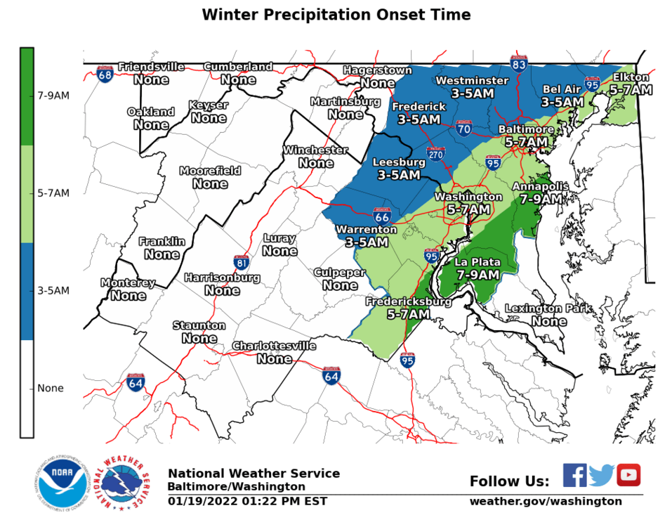
12z Euro would bring DCA to full climo for the year in mid January. Also, this: -
-
-
Yup, they are neato! Not for those who keep their expectations reasonable. Honestly, two observations from this winter: 1.) GFS clearly has been better than past performance, big win for NWS/NOAA NWP. 2.) GFS seems to have better verification the past few winters for northern stream events.
-
These are called gravity waves, or cloud streets: https://rammb.cira.colostate.edu/wmovl/vrl/tutorials/satmanu-eumetsat/satmanu/cms/ClStr/index.htm
-
Thursday 1/20/22 Stat Padder Discussion and Observations
Eskimo Joe replied to stormtracker's topic in Mid Atlantic
Yes. -
Thursday 1/20/22 Stat Padder Discussion and Observations
Eskimo Joe replied to stormtracker's topic in Mid Atlantic
Put a 1/2" flash freeze snow on all the roads. Let the chaos ensue. Then we feast on cold powder on Saturday. -
It was consistently too far east until we got within 24 hours, then it go in line with the OP.
-
No


