MazooWeather
-
Posts
3,864 -
Joined
-
Last visited
Content Type
Profiles
Blogs
Forums
American Weather
Media Demo
Store
Gallery
Everything posted by MazooWeather
-
SVA issued for the northwestern part of IWX's CWA, storms are popping rn
-
We have clearing here finally, sun is peaking out. IWX is saying storms should fire soon and could be tornadic for a few hours.
-
You should definitely have enough time to get there, it's still raining and the lull hasn't started yet
-
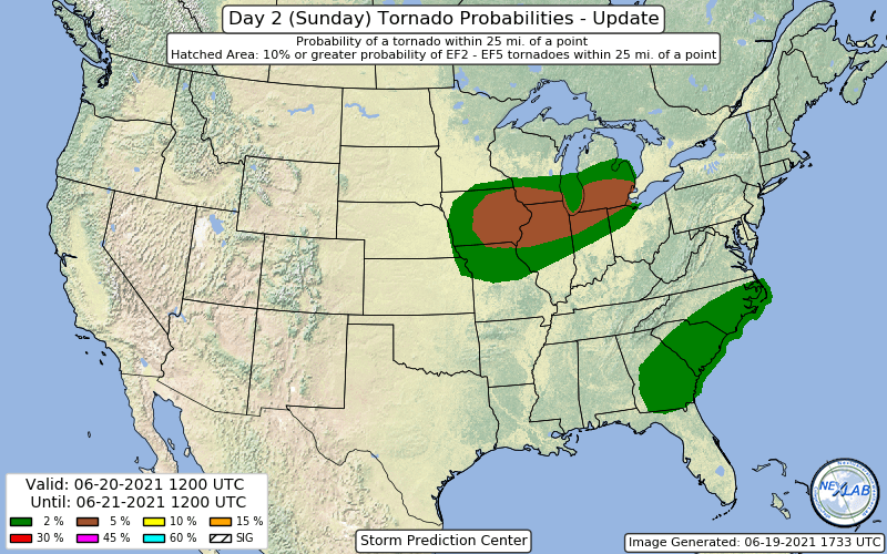
SPC saying we could have some LLJ fueled naders tomorrow evening
-
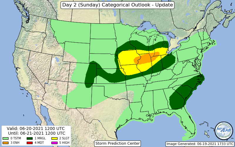
Saturday has a good setup for Severe Weather across lower Michigan and Northern Indiana, only real limiting factor will be instability.
-

June 20th, 2021 Severe Weather Event
MazooWeather replied to MazooWeather's topic in Lakes/Ohio Valley
An event like this at least shows that lead time saves lives, it sounds like a lot of people took shelter before it hit -
June 20th, 2021 Severe Weather Event
MazooWeather replied to MazooWeather's topic in Lakes/Ohio Valley
Radarscope -
June 20th, 2021 Severe Weather Event
MazooWeather replied to MazooWeather's topic in Lakes/Ohio Valley
Tornado warned hook echo near Van Buren Michigan -
June 20th, 2021 Severe Weather Event
MazooWeather replied to MazooWeather's topic in Lakes/Ohio Valley
You ok!? -
June 20th, 2021 Severe Weather Event
MazooWeather replied to MazooWeather's topic in Lakes/Ohio Valley
SPC coordinating a new downstream watch -
June 20th, 2021 Severe Weather Event
MazooWeather replied to MazooWeather's topic in Lakes/Ohio Valley
Sounds like it probably did and I got spared by like 5 miles -
June 20th, 2021 Severe Weather Event
MazooWeather replied to MazooWeather's topic in Lakes/Ohio Valley
Dodged a bullet here but theres some damage in Branch County, hope everyone is ok -
June 20th, 2021 Severe Weather Event
MazooWeather replied to MazooWeather's topic in Lakes/Ohio Valley
Tornado just hit Coldwater Airport in Michigan -
June 20th, 2021 Severe Weather Event
MazooWeather replied to MazooWeather's topic in Lakes/Ohio Valley
TOR Possible in NW Ohio, has decent rotation atm -
June 20th, 2021 Severe Weather Event
MazooWeather replied to MazooWeather's topic in Lakes/Ohio Valley
Baseball size hail in Berrien County MI rn -
June 20th, 2021 Severe Weather Event
MazooWeather replied to MazooWeather's topic in Lakes/Ohio Valley
-
June 20th, 2021 Severe Weather Event
MazooWeather replied to MazooWeather's topic in Lakes/Ohio Valley
We have initiation around Chicago and in NW Indiana -
June 20th, 2021 Severe Weather Event
MazooWeather replied to MazooWeather's topic in Lakes/Ohio Valley
The 80% MD has expired and it looks like no watch still -
June 20th, 2021 Severe Weather Event
MazooWeather replied to MazooWeather's topic in Lakes/Ohio Valley
Place bets if they go tornado or severe watches -
June 20th, 2021 Severe Weather Event
MazooWeather replied to MazooWeather's topic in Lakes/Ohio Valley
MCV has formed out west as expected and is wickedly strong -
June 20th, 2021 Severe Weather Event
MazooWeather replied to MazooWeather's topic in Lakes/Ohio Valley
Could these storms tonight help set down additional outflow boundaries for the stuff tomorrow? -
June 20th, 2021 Severe Weather Event
MazooWeather replied to MazooWeather's topic in Lakes/Ohio Valley
Surprise Severe Thunderstorm Watch time! -
June 20th, 2021 Severe Weather Event
MazooWeather replied to MazooWeather's topic in Lakes/Ohio Valley
Rotation is tightening up on it right as it heads towards town -
June 20th, 2021 Severe Weather Event
MazooWeather replied to MazooWeather's topic in Lakes/Ohio Valley
TOR possible SVR in Cass County Michigan rn, has a little hook in it and some rotation -
Nobody else has made it so here we go