MazooWeather
-
Posts
3,866 -
Joined
-
Last visited
Content Type
Profiles
Blogs
Forums
American Weather
Media Demo
Store
Gallery
Everything posted by MazooWeather
-

June 20th, 2021 Severe Weather Event
MazooWeather replied to MazooWeather's topic in Lakes/Ohio Valley
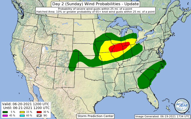
TOR possible SVR in Cass County Michigan rn, has a little hook in it and some rotation -
Nobody else has made it so here we go
-
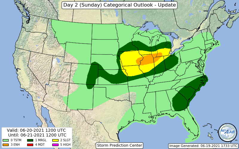
Wondering if they're gonna go Enhanced or wait til tomorrow
-
Large Day 2 Slight Risk introduced 5/15/15
-
IWXs afternoon update looks like they've punted
-
Emergency Management is reporting many trees and power lines down from the line that just went through here
-
Could be some damaging winds and microbursts locally today, hopefully IWX finally breaks their warning drought.
-
18Z GFS is same track as 12Z, guess we'll see what 0Z does
-
Was just typing a post too, it absolutely crushes around here. Could potentially be the biggest storm of the season in spots
-
That 18Z GFS run is spicy for Northern Indiana and Lower Michigan
-
IWX calling for 4 to 8 in the AFD. Getting our second Winter Storm Warning of the winter this late would be hilarious
-
GEM is the same but even more widespread
-
The 18Z GFS would actually be a fairly big storm for parts of Southern Michigan
-
Clipper time
-
..2220Z UPDATE A LONG-TRACK, STRONG TO POTENTIALLY VIOLENT TORNADO IS ONGOING ACROSS CENTRAL AL AND WILL LIKELY PERSIST TOWARDS THE GA BORDER GIVEN A FAVORABLE ENVIRONMENT. HAVE EXPANDED THE CATEGORICAL RISKS SOUTHEAST TO ACCOUNT FOR THIS EXTREMELY INTENSE SUPERCELL.
-
Personally I think this just gonna cause more confusion but we'll see what happens.
-
Will we actually get a decent severe outbreak this season, I think everyone here is craving a good moderate or high risk day to track
-
Just started snowing here, decent clip for what radar shows, really fun stuff is a few hours away
-
A lot of people are gonna be shocked to see the quick warning upgrades in places
-
Feb 3rd - 5th Potential strong stm threat
MazooWeather replied to Brian D's topic in Lakes/Ohio Valley
That 30 mins was probably the heaviest rates I've seen in person in a couple years, put down a quick 0.75 here -
Feb 3rd - 5th Potential strong stm threat
MazooWeather replied to Brian D's topic in Lakes/Ohio Valley
Snowfall rate went from zero to 100 in like 10 minutes here -
Feb 3rd - 5th Potential strong stm threat
MazooWeather replied to Brian D's topic in Lakes/Ohio Valley
And don't forget the massive wind factor in this event, so it's all gonna go everywhere too -
Feb 3rd - 5th Potential strong stm threat
MazooWeather replied to Brian D's topic in Lakes/Ohio Valley
0Z suite basically just tells us there's a lot up in the air still lol -
January 30-February 1 Winter Storm Part 2
MazooWeather replied to Hoosier's topic in Lakes/Ohio Valley
Temps have been holding in the mid 20s here, snowing decently. -
It's nice to have lots to track again