packfan98
-
Posts
2,549 -
Joined
-
Last visited
Content Type
Profiles
Blogs
Forums
American Weather
Media Demo
Store
Gallery
Everything posted by packfan98
-
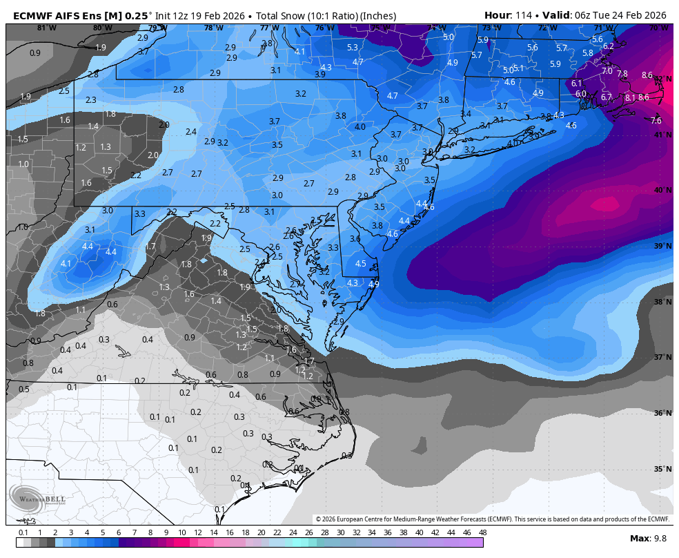
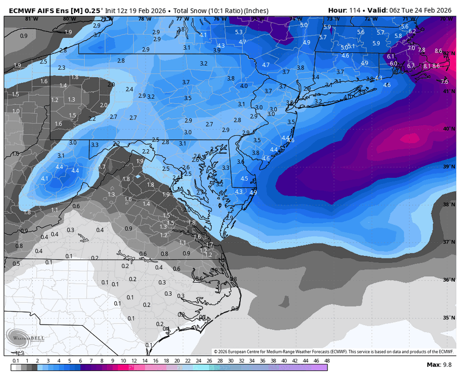
AIFS ENS has been trending much better for you guys. Best of luck.
-
UKMET looks to be a bit hit for you guys. We lost our piece of it yesterday, so I'm living vicariously through you. Good luck! Here's the final frame with what looks like plenty more to come.
-
Not many. Small hints on the nam and euro at some points, but the in house models from the local tv stations were the best and most aggressive by far.
-
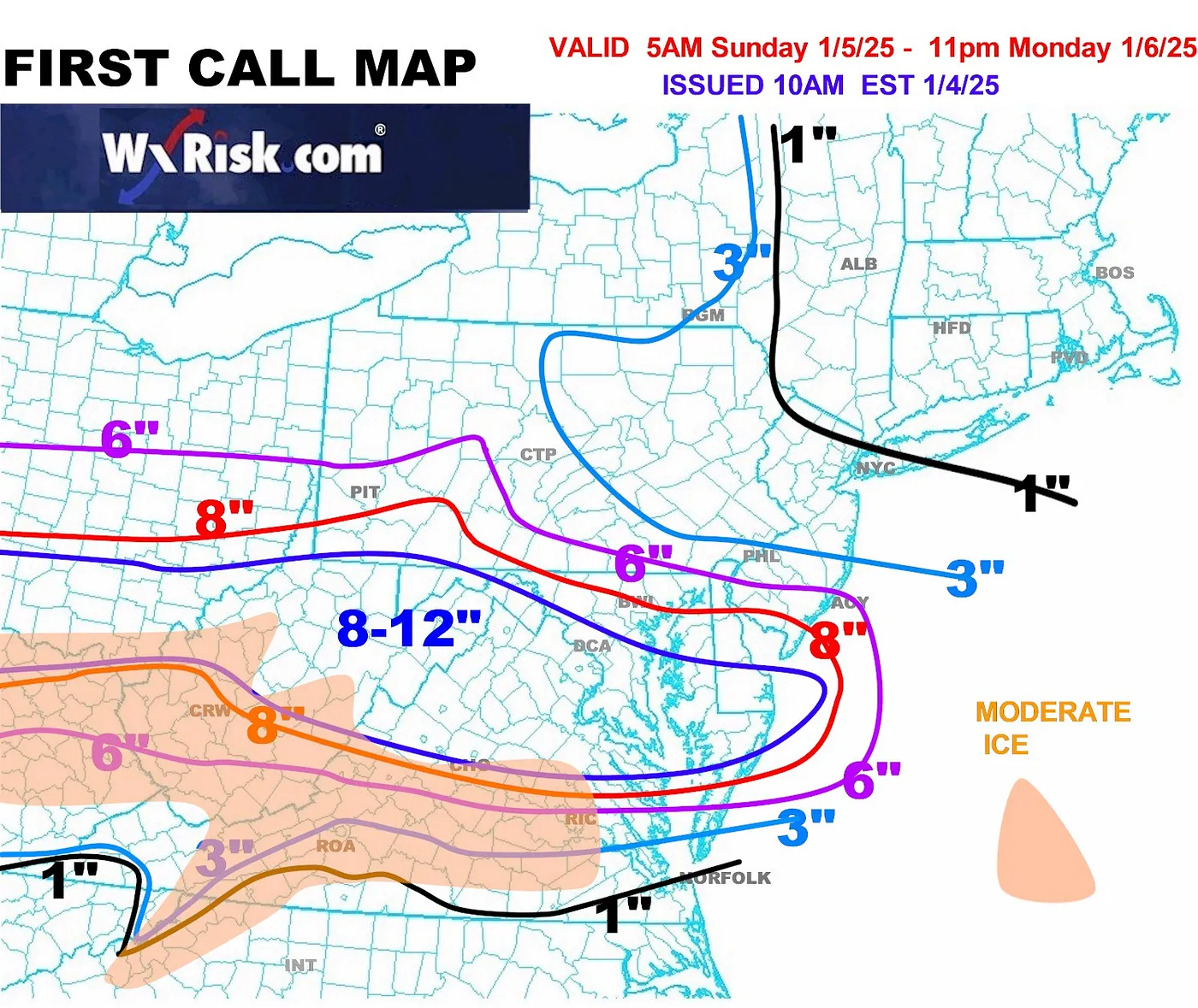
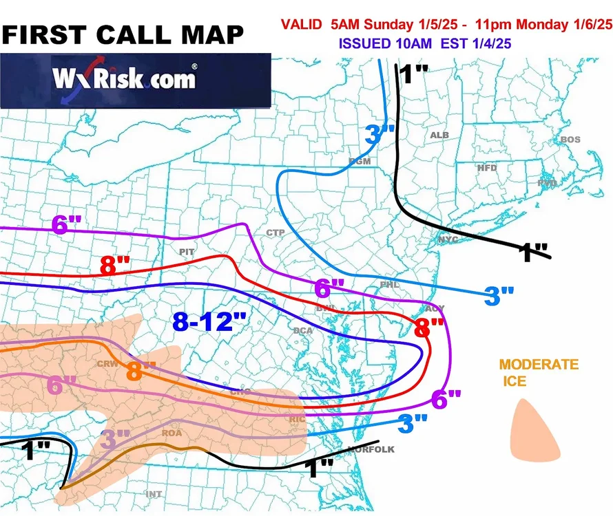
Call map from DT. Good luck everyone.
-

January: Medium/ Long Range: May the Force be with Us....
packfan98 replied to Weather Will's topic in Mid Atlantic
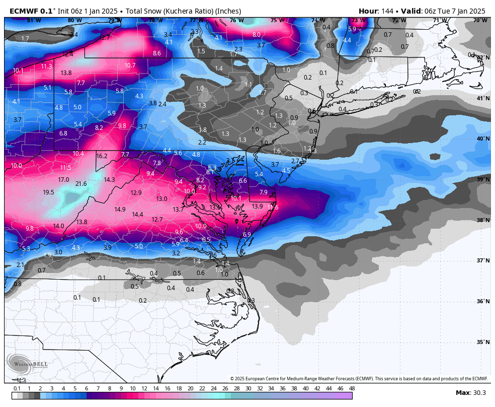
Happy new year! 6z euro. Very similar 0z. Surface low was a tad weaker and further south, but totals ticked up for many.
-
The Weekend Rule? Saturday 2/17 - The Icon Storm
packfan98 replied to DDweatherman's topic in Mid Atlantic
EPS trends look great for you all. Good luck! -
2024 Valentines Day Who the Hell Knows - Comeback Thread
packfan98 replied to DDweatherman's topic in Mid Atlantic
Basically shifted everything south a county or so. -
2024 Valentines Day Who the Hell Knows - Comeback Thread
packfan98 replied to DDweatherman's topic in Mid Atlantic
Good luck on reeling in another storm! -
Jan 19th Snow on Snow: the this always works until it doesn't thread
packfan98 replied to psuhoffman's topic in Mid Atlantic
-
Jan Medium/Long Range Disco 2: Total Obliteration is Coming
packfan98 replied to Jebman's topic in Mid Atlantic
Yep. Good luck folks. -
I just saw @Bob Chill post in the mid Atlantic forum. Great seeing him post again. One of my favorite all time contributors. Welcome back, sir. You’ve been missed!
-
6z is running now. Let’s see what it looks like.
-
Pivotal Weather has them for free.
-
Here's where the RGEM ended up. I'm trying to avoid an ice storm down here in NC. Good luck to y'all up there in the powdery regions!
-
Here's the NWS Raleigh Discussion: As of 350 PM Sunday... Surface low has emerged off the SE Coast and will pull slowly east- northeast away from the NC coast as a series of shortwaves eject east through the base of mid/upper level trough trough in place across the SE US. Per 18z/9 GSO sounding, the cold deep near freezing isothermal layer did indeed prevail across the far northern/northwestern Piedmont, in the heart of the cold air damming region in place east of the mountains. As of 20z, latest reports coming in across that region have a snowfall maximum of 14 to 14.5 inches across Forsyth and Person counties. However, impressive mid-level dry punch overspreading the area from the west signals the loss of saturation aloft and ice crystals aloft, which will largely end the production of accumulating snow and sleet, that is until the arrival arrival of the next shortwave later this evening and overnight. Thus, expect the snow/sleet across the far northern zones to change-over to light freezing rain/drizzle to occur within the next hour. The approach of the upper wave late this evening and overnight will lead to re-saturation and cooling aloft. At the same time, weak cold dry air advection on the back-side of the surface low moving farther offshore, will result in near to sub-freezing temps across the the northern two-thirds of the forecast area. The re-introduction of lift and ice into the cloud will result in another period of light snow/sleet across spreading east across the area. Additional snowfall amounts are expected to be light, ranging between a half inch to 1 to 1.5 inches across the far northern zones. While the far SE counties could see some a mix wet snow and rain, above freezing temps in the mid 30s will result in little to accumulation.
-
NWS Raleigh is going for around an inch of accumulation tomorrow. Here are the expected and max potential maps:
-
RGEM has it too:
-
Do you think there will be any significant icing? Seems like some of the models are picking up on the potential just SE of the Triad between Charlotte and RDU. I'm in NW Randolph Co just south of Archdale and am hoping to stay snow/sleet and avoid an ice storm.
-
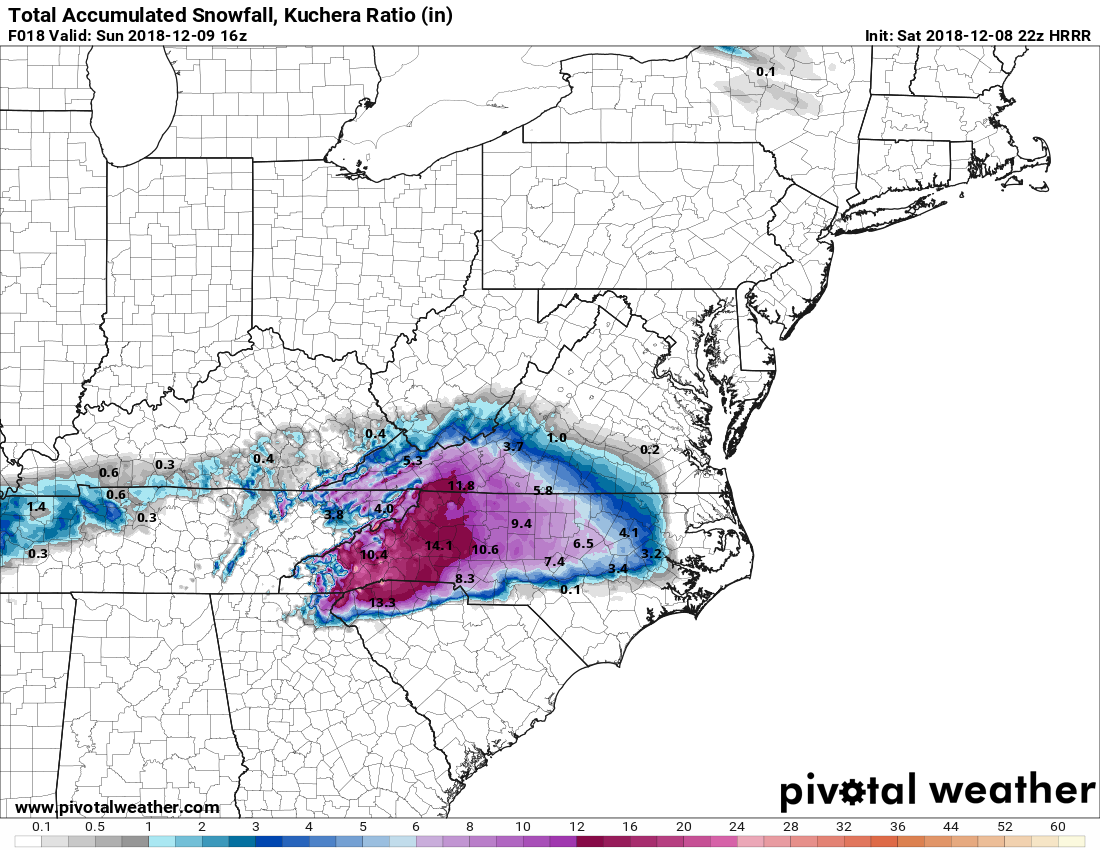
And the Kuchera map from 22z HRRR from Pivotal.

-
There’s a separate map for freezing rain but not sleet. I would imagine cutting the totals on the map in half would be closer to reality.
-
Matches pretty well with the Kuchera map from Pivotal:
-
@griteater have you had a chance to look at the 6z euro? I’m curious if there were any changes, especially with the transition lines. Thanks!
-
Thanks for the information, and the well wishes!
-
Anybody have access to the 18z Euro? @griteater???
-
So many great model runs this week! Tomorrow is game time. Buckle up!