

snowman19
-
Posts
7,450 -
Joined
Content Type
Profiles
Blogs
Forums
American Weather
Media Demo
Store
Gallery
Posts posted by snowman19
-
-
2 hours ago, bluewave said:
We will need to see the MJO forcing west of the Date Line fade out a bit to get some Improvement. The current lingering and lag with the MJO in phase 6 flipped the PNA negative. Need to weaken the -PNA as the month progresses to get the gradient to our south and see colder temperatures again.

The new CANSIPS has a huge RNA/-PNA pattern for February
-
 1
1
-
-
36 minutes ago, Brian5671 said:
If it comes at all. The 1st week Feb Warmup was only seen about a week out. Who knows what it will look like come 2/15....modeling has been horrid this winter...
Some people had basically guaranteed we would be in MJO phase 8, cold and snowy the 1st 2 weeks of February and look at what happened
-
 2
2
-
1
-
-
49 minutes ago, Snow88 said:
Which ensembles ? Eps is not ugly right into mid month.
There is a decent signal for a storm around the 11-12 but too early for details.
We’ll see what happens post 2/15 but up to that point it does not look good
-
 1
1
-
1
-
-
1 minute ago, bluewave said:
Looks like the coming warm up with the -PNA in early February is a result of the slower passage of the MJO through phase 6.


The new ensembles are ugly right into mid month
-
1
-
-
7 hours ago, Brian5671 said:
12 days away-pure fantasy at this point...
The ever elusive “MJO phase 8” and “Euro weeklies” for the last 2+ months. They’re both like Clark Kent and Superman, one on a model forecast and one in reality, they’re never seen together...
-
 1
1
-
-
-
7 minutes ago, Dark Star said:
Line appears to be falling apart as it exited the Harrisburg area.
Downsloping effects off the Apps? The new HRRR, NAM 3K, 12K and RGEM are all unimpressive
-
1
-
2
-
-
6 minutes ago, CPcantmeasuresnow said:
1918/19 0.6 inches Nov through January
1931/32 0.9 inches in Dec and January but 2.0 inches in November
1994/95 0.2 inches Nov-January, What a nightmare
1997/98 0.5 inches Nov-Jan, another nightmare.
We really paid dearly for 93/94 and 95/96 with some of the biggest clunkers ever in the 90's
and of course this year 0.7 in December and January and 6.4 in November
Thank you. Yea, this winter going into February, definitely ranks right up there with 94-95, 97-98, 01-02 and 11-12 for NYC’s worst in the last 25 years
-
1
-
-
2 hours ago, Brian5671 said:
One of the most boring January's in quite some time. Even the clunkers of 01-02 and 11-12 had snow in January...
Are there any other years where NYC went from mid November into early February with an inch or under of snow? I honestly can’t find one. Today definitely isn’t promising on the HRRR, NAM or RGEM
-
1
-
-
24 minutes ago, PB COLTS NECK NJ said:
Dude , the next 5 days are well BN with 2 shots of light snow , Your " breakdown " is a 5 to 7 day period of AN , then it`s back ( in the 10 -15 ) as we head towards p8.
You guys think it`s over ? Good luck bud.


Yep, sure. You condescendingly degraded posters as usual for suggesting this breakdown was even coming at all, arrogantly, as you always do, as if you control the weather and tell it what to do. Then when the news is bad you disappear, then reappear to lecture people. And the cold is lasting less than 5 days. It’s going bye bye come Saturday. MJO phase 8, how long have we heard that battle cry now? 3 weeks. It’s coming, it’s coming. So is met spring in 4 weeks from now
-
1
-
2
-
-
4 minutes ago, Snow88 said:
You cancelled winter in January.
No, no I actually didn’t. But you on the other hand have been calling for cold and snowstorms since the end of November.
-
1
-
1
-
-
On 1/24/2019 at 12:08 PM, PB COLTS NECK NJ said:
I love to see guidance that maybe I missed , I was hoping he could show me. Another BOZO in here from Red Bank posed in here a week ago that the upcoming period would have the trough in the west.
He`s going to test zero during that period.
Oooops. I told you the pattern was breaking right down but as always you condescendingly “opined” and degraded people. Karma
-
1
-
1
-
-
10 minutes ago, Brian5671 said:
JB had originally talked of a long lasting severe cold snap that would stretch resources thin....he's not talking about that anymore and is stating the models are too strong on the warm up next week. (certainly trying to keep the ship afloat, but it's taking on more water than the pumps can handle...)
Soon, JB is going to be Casey Jones
-
1
-
1
-
-
45 minutes ago, The Iceman said:
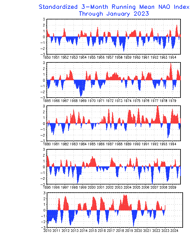
People went gung ho on a -NAO winter when all signs in fall pointed towards it being positive especially when we saw the dip negative in mid november before it shot right back to positive. The WAR that had been in place since summer refused to die and was also completely ignored in many forecasts. Too many based their long range based off analogs and what was supposed to happen in a weak modoki nino instead of analyzing the current pattern in the fall. There were red flags. The 3 month running average for the NAO was positive for most of 2018, and this was completely ignored. There is a trend for the NAO to favor one phase or another over a long period of time and there wasn't anything that jumped out to me why this would change. Their were some interesting theories on why we'd see a neg nao but they have all came up empty this year. Sometimes simple is best.
We are entering a long term -AMO phase. -AMO is correlated with predominant +NAO. Opposite for +AMO. -AMO is also associated with fewer KU events overall
-
1
-
-
1 hour ago, Brian5671 said:
The long lasting severe cold option looks to be dwindling too....with no blocking a fast flow (pac jet) cold is in and out...
As long as you have this raging PAC jet, it’s going to be a huge problem: https://www.tropicaltidbits.com/analysis/models/?model=gfs-ens®ion=npac&pkg=uv250&runtime=2019012706&fh=384
-
11 minutes ago, LongBeachSurfFreak said:
1. We see accumulating snow Tuesday night.
2. After the cold and dry period we see a transient warmup associated with MJO 6/7
3. As the MJO goes into 8 we are approaching the absolute peak of snow climatology and more specifically for KU storms.
4. A -NAO developes in the long term.
We go through this snowless how?
I’ll believe the -NAO when it actually happens
-
1
-
-
3 hours ago, bluewave said:
At least for a while. A more -PNA La Niña-like pattern takes over during the first week of February. We then have to wait and see what happens after that. The -PNA interval looks like a MJO 6 pattern.


There are big problems beyond the 1st week of February too. Look at the strength of the PAC jet going into mid month. It’s absolutely raging, zonal and aimed directly at the CONUS
-
20 minutes ago, nycwinter said:
it's summertime in australia so of course the sst are going to be very warm....
Ummm that’s an anomaly above average map, so yea, they are wayyy above normal lmaooo
-
20 minutes ago, bluewave said:
The record MJO activity in recent years with all the SST warming in the Western Pacific is becoming a new wild card. Very hard to issue a successful seasonal forecast in the fall when the MJO is creating these non-canonical ENSO responses.

Yep the SSTS are on fire out that way, sustaining the positive feedback process and beefing up the latent and sensible heat releases through strong convection and evaporation
-
1
-
-
18 minutes ago, bluewave said:
The MJO 6-7 forcing is stretching the El Niño forcing just east of the Date Line back toward the Western Pacific. So we get all these overlapping teleconnection factors and big temperature swings. This is creating a non-canonical forcing pattern for El Niño.


That’s the problem, right there. All the tropical convective forcing is well west of the dateline, around Australia. There has been an explosion of tropical storm activity around/north of Australia recently. All that convective, latent heat release into the upper troposphere helps to really strengthen and push the west Pacific High poleward. A strong poleward west Pacific High promotes the pattern the long range ensembles are showing. Look at the SSTs out that way, they are on fire, helping the positive feedback process and latent heat release
-
Just now, Snow88 said:
You always have doubts every winter. Your trolling gets old.
This isn’t trolling. Do you not read? I was calling a pattern change to cold and snowy after mid January back in December and early this month. Remember all my posts? All you ever do is hype cold and snow every winter. You’ve literally been calling for cold and snow non stop since mid November after that one snowstorm we’ve had all winter. What has happened? The city has yet to see one inch of snow since then and every month has been above normal for temps
-
3
-
-
33 minutes ago, Ji said:10 hours ago, donsutherland1 said:Probably somewhat afterward. The guidance has tended to rush the development of a NAO- this winter.
In 10 days euro has a blowtorch.
It (EPS) actually starts to get really bad around day 8 but yea the pattern turns into a disaster in the 1st week of February. GEFS and GEPS also show this. At that point we are less than 4 weeks away from met spring. I have serious doubts as to whether we ever go into a sustained cold and snow pattern before winter’s end now
-
4 minutes ago, LibertyBell said:
yes 14-15 had the amazing turnaround the Pac was GREAT that year
14-15 had a classic, very strong ++PDO which we don’t have the luxury of now. It played a huge role in the very favorable Pac side we had back then
-
Just now, SnoSki14 said:
We haven't necessarily needed it but that's because the Pacific blocking had been stellar. This year, so far, we haven't had either so it's been crappy.
The Pacific has refused to cooperate since late November yes. We were spoiled and compensated for the NAO and AO not being favorable the last several winters. Just based on what I’m seeing now, like I said before, the Pacific is looking to become hostile again come week 2 of February. Question is, is it a week of being unfavorable or something more lengthy?
-
1
-
1
-


February 2019 General Discussion and Observation Thread
in New York City Metro
Posted
The CanSIPS may not have been so crazy. The model runs last night are ugly right past mid February