

snowman19
-
Posts
7,449 -
Joined
Content Type
Profiles
Blogs
Forums
American Weather
Media Demo
Store
Gallery
Posts posted by snowman19
-
-
19 minutes ago, Snow88 said:
Some gefs have some snow for the area for the 3rd. Long shot but interesting.
Unless the low absolutely bombs and dynamically cools the column from aloft with strong UVVs (extremely unlikely) this is an all rain event, even up into New England. By the time it gets here, there is just no cold air anywhere around to pull from. Lost cause
-
 1
1
-
-
8 minutes ago, bluewave said:
Not going to see much change in this pattern yet until we lose that ridge north of Hawaii. It will probably take time since we are coming off such an anomalous +SOI December for an El Niño.
Average SOI for last 30 days9.23


94-95 may not have been such a horrible analog after all
-
3 minutes ago, SnowGoose69 said:
The big question is does the storm track suddenly go dead. It’s hard to believe we can hold this type of activity all winter. When we finally flip we may end up drier. Even in an El Niño it’s hard to keep things going the whole way through.
I honestly was thinking about the same thing. Eventually the faucet is going to turn off. I know everyone wants -NAM and I’m pretty sure that’s what’s coming but it may equal suppressed storm tracks even with an active STJ once the pattern change occurs
-
53 minutes ago, donsutherland1 said:
Despite the predominance of clouds and a brief period of light snow during the morning, the implied probability of December's averaging 40.0° or above in New York City has increased further based on the sensitivity analysis applied to the guidance. The implied probability is now 79%. The most likely range has narrowed to 40.1°-40.3°.
In terms of annual precipitation, New York City has received 64.53" to date. That ranks as the 5th highest figure on record. Based on sensitivity analysis applied to the guidance (through 18z), there is a 50% implied probability that New York City will reach 65.11" before midnight tomorrow night. That would tie 1989 as New York City's 4th wettest year on record. There is an implied probability of 46% that New York City's 2018 total will exceed 65.11".
The 12/29 MJO data (RMM) is in. The MJO remained in Phase 5 for the 12th consecutive day with an amplitude of 2.547. This ties the December record for most consecutive days in Phase 5. The record was set during the December 7-18, 1994 period. The amplitude is down from the 12/28-adjusted figure of 2.854.
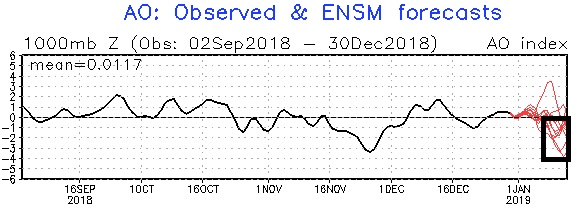
The MJO will very likely move into Phase 6 in the next 1-3 days at a high to very high amplitude. During the second week of January, it will likely progress into Phase 7. Initially, both the SOI and Arctic Oscillation (AO) will likely remain predominantly positive. However, as the MJO approaches and then moves into Phase 7, the SOI will likely go persistently negative and the AO will also become increasingly negative. The second half of January could see a predominant PNA+/AO- combination. Such a combination has coincided with some of the region's biggest January snowstorms.
Perhaps as a hint of the Atlantic blocking that could develop in the extended range, a majority of GEFS members now show the AO going negative during the second week of January.
For New York City, the move to Phase 7 will coincide with the growing risk of at least a moderate (4" or greater) snowstorm. Should the MJO progress to Phase 8 afterward, the risk of a moderate or greater snowstorm will increase further.
Since MJO daily data was recorded beginning in 1974, 39% of New York City's 4" or greater January snowstorms occurred during Phases 7 or 8. During El Niño winters, that figure was 56%. No such snowstorms occurred during Phase 6 in El Niño winters.
I still think we see a turn at the end of January. I rushed things expecting a full fledged pattern change at mid-month but as of now I can still see the tide turn afterwards. It’s obvious after the last few days that this is going to be a slow transition
-
9 minutes ago, Snow88 said:
Steve D
NY/NJWeather
Well, the stratospheric warming is happening right now. Now we see how the dominos fall. Sit back and relax, ENJOY THE SHOW!
This is the same Steve D who said last year’s SSW in February was going to do nothing and vehemently declared winter over. Then March happened
-
 1
1
-
-
I won’t wait until it’s blatantly obvious to fail, but my call for a pattern change for mid-January isn’t going to happen as it stands now. Too soon. It was mentioned already, but this unfavorable MJO wave was so strong and persistent that it’s going to have atmospheric lag effects. I also don’t think the SSW is going to be of much, if any help at all, the vortex is most likely going to dump on the other side of the hemisphere. I’m still hopeful for late January but it’s becoming obvious over the last few days that the pattern isn’t going to be in a full scale change by mid month
-
Just now, dendrite said:
It's burying the southern stream longer in the SW. It's probably wrong, but we'll see what the euro does.
Yea, the UKMET evolution just looks odd. It would be an inside runner and rain anyway which I’m sure no one wants
-
51 minutes ago, NutleyBlizzard said:
If that happens there would be some big time weenie cliff diving going on including yours truly.

Worst case scenario for January at least. Then you will be depending on February and March for a big flip and by then you start to fight against the clock
-
26 minutes ago, Snow88 said:
Or the pv splits and ends up on the other side of the world. See eps.
You’re 100% right. If that happens we are in real big trouble and my call for mid January busts and busts badly
-
1
-
-
3 minutes ago, doncat said:
I enjoy storms of all sorts not just snow, but even I'm sick of the rain. 12z euro, still don't see any meaningful changes... maybe by day ten as colder air starts to push south.
I think it’s getting clearer by the day that we will wait until 1/15 or shortly thereafter before we see a meaningful, lasting change to a colder, snowier pattern
-
1
-
-
27 minutes ago, SnowGoose69 said:
The AO I believe averaged negative that winter there was something that mucked everything up outside the Niño but I forget what it was. We had the AO in 09-10 which was a very strong Niño as well relatively speaking.
The super Niño forced a ++EPO pattern. It completely overwhelmed the arctic and Atlantic signals
-
15 minutes ago, dmillz25 said:
Yeah if it was like 5 degrees colder 97-98 would have been epic
Thank you Rjay. Anyway, in response to dmillz post, the problem with 97-98 was the insanely positive EPO, which was caused as a result of the super El Niño we had in place back then. The NAM (AO/NAO) actually was good that winter, it was just that the Pacific ++EPO signal was so strong that it completely overwhelmed everything
-
1
-
-
2 minutes ago, Snow88 said:
Another rainstorm for the 4th on the Euro
SMFH
The pattern is still going to be horrible then
-
26 minutes ago, ORH_wxman said:
I think we need to see deeper into January before get worried. Honestly, this is eerily similar to 2014-2015 in a lot of ways...in fact, December was colder and had more opportunities than 2014 did, but we whiffed on them so we ended up with similar near-zero snowfall that 2014 had.
Early January 2015 had big arctic cold shots mixed with torching cutters....the pattern was changing, but we were still getting on the wrong side of the initial arctic gradient...i.e., chaos continued to conspire against us even though we probably could have easily gotten a nice SWFE if the nuances lined up correctly.
Finally the PNA ridge established itself further east by late January and we were off to the races. Again, I'm not predicting we will repeat that 100" in 3 weeks type insanity...but even a much toned down version (like 50" in 5 weeks) would obviously completely change the tenor of the winter. I don't see signs of failure yet in the progression. If it starts showing up, I'm definitely going to post my concerns.
Wasn’t 14-15 helped in large part by the very ++PDO? If I remember correctly, I think the PDO was well over +2 for Jan-Mar, 2015. It’s nowhere near that positive now
-
2 minutes ago, NutleyBlizzard said:
It's unfortunate we had to lose December thanks to the MJO being in a warm phase for the most part. People need to stop freaking out though. WE are currently going through a SSW warming event as we speak. Once that rubber band snaps back post Jan. 10th and we get a full pattern reversal, this board will be rocking.
A SSW doesn’t guarantee a cold east. It could split or displace in a bad spot. It can fail to downwell to the troposphere and couple
-
4
-
-
8 minutes ago, Snow88 said:
Imagine if this happens?
Winter forecasts will all fail
If that actually happens, we’re in big trouble, for January at least
-
1
-
-
54 minutes ago, bluewave said:
Get ready for some longer range model volatility with the fire hose Pacific Jet development near Japan.

If the jet configuration still looks like this come 1/15, it will be a very bad sign. I’m sticking with my thoughts for now, but not going to lie, after today’s guidance, I’m starting to wonder. That is a very troubling sight
-
1
-
-
13 minutes ago, 495weatherguy said:
Should I interpret this to mean that the PAC can mean a more zonal flow and moderate temps/less snow?
I’m not anticipating it, but if we get to mid-January without the change in the Pacific that I think is coming, and a change is not at least imminent, on the doorstep at that point, then it will be time to get worried. Like I said, I don’t think that’s going to happen. You also don’t need the SSW for the change, the tropospheric forcing should do that on its own without any help from the stratosphere. There are serious doubts emerging today from the experts on the SSW and what actually happens with it anyway, it may not even downwell enough to affect the tropospheric pattern and a split, if it even happens now or a displacement may very well not be favorable for the east this time like it was back in March
-
1
-
-
4 minutes ago, donsutherland1 said:
NYC has only seen 40" or more one time in the January 15-March 1 timeframe. During January 15, 2014-March 1, 2014 total snowfall was 42.3".
Thank you Don. I didn’t look up the actual data but I knew such a scenario was not only unlikely but an extremely rare feat. Even if extended 3 more weeks to 3/21, an extreme rarity still I’m sure
-
1
-
-
2 hours ago, 495weatherguy said:
A serious question-if we are going to enter an active, wintry period, say Jan 15-March 1, what are the odds of 40 plus inches of snow during that time frame?
Over 40 inches of snow in the metro between 1/15-3/1? You’re talking historic. Can a few real big storms and a couple of small events in between get you there? Sure. Would I predict such a pattern? Nope
-
53 minutes ago, SnowGoose69 said:
New Year’s Eve looks remote to me at this time. There isn’t a whole lot of room there to get that thing more amped without also poisoning the air mass in place. It’s likely that if that comes far enough up its rain anyway
^This. It’s very remote. The 12/30-1/3 time frame is still really bad for snow here. People need to be patient
-
1
-
-
15 minutes ago, TwcMan said:
We need that EURO back..
Honestly, over the last couple of winters, the Euro has lost a lot of its luster. Flip flops and busts a lot more than I can ever remember. The Para GFS has definitely not been the best either, the guys in the NE forum just pointed this out as well
-
3
-
 1
1
-
-
8 minutes ago, Snow88 said:
So you favor a miss or rain ?
If something actually happens I think it’s minor and rain, most likely a miss though. You will get your cold and snow pattern come mid January and it probably lasts for awhile, into mid to late February then it’s game over for winter IMO. I don’t think March is going to produce this time. And you don’t need this ridiculously hyped SSW for it to happen, the tropospheric forcing will do it anyway on its own, even without help from the stratosphere. Sunday, in my opinion, is not for us
-
1
-
-
1 hour ago, NEG NAO said:

The pattern on Sunday will still be poor for a snowstorm in the metro. It’s not just going to flip conducive in 5 days, it’s going to take time, but it will get there. It’s obvious that the change is coming but not that early, it’s going to take a couple of weeks...


January 2019 General Discussion & Observations
in New York City Metro
Posted
The Euro weeklies (IF correct) have it above normal until January 15th, then start the pattern change transition January 15th and it’s complete by January 21st. The pattern finally goes below normal come January 21st or shortly thereafter and beyond, again if the ECMWF weeklies are indeed correct, I guess we’ll see