

snowman19
-
Posts
7,450 -
Joined
Content Type
Profiles
Blogs
Forums
American Weather
Media Demo
Store
Gallery
Posts posted by snowman19
-
-
55 minutes ago, Snow88 said:
Mostly sleet
For once we agree. The mid-levels are torched, it’s not snow, it’s sleet and the UKMET has been overdoing snow/too cold all winter long. I tried warning you yesterday that this was a completely horrible snow setup for the metro area but somehow it got twisted into me saying it because I’m a bad person. This is going to be a mostly rain event come Tuesday, the red flags are all out, warning bells are sounding. The models are not done trending warmer here, mark my words. The theme of this winter, and of the horrible teleconnections and lack of Atlantic blocking. By Sunday and Monday they will be much warmer than what we have today and snow amounts will be dropped even further. Watch the cutting primary, parent low become stronger and stronger and the idea of secondary coastal redevelopment go by the way side
-
1 minute ago, Neblizzard said:
I remember when you were banned for 4 months last year. Too bad it wasn’t permanent. Again your analysis is horrible, the models have trended east with the ridge over Alaska ( it’s more -EPO). The confluence over Canada acts as your block. So if that is right on the models this will not be a warm solution. The MJO heading into a favorable phase 8-1 is going to take about another week before the models fully grasp onto the pattern. I think this winter will end much like last years.
Your post is going to be great to bring back again next week. Lol. Talk about atrocious analysis, it’s your post. MJO has a lag so even if it went into “Phase 8” next week the effects aren’t immediate, read up. If you think this is a good setup for a snowstorm in the metro area I wish you God speed. This winter is going to end just like last year? Based on what? Wishes, hopes and prayers. There is nothing that even remotely matches the pattern progression of last year, like not even close, not even in the ballpark. But you go ahead with March, 2018
-
 1
1
-
 1
1
-
 1
1
-
-
24 minutes ago, SnoSki14 said:
Respectfully disagree, I think the confluence will shred that primary apart. Just look at the Ukmet.
It's not horrible at all. You don't need a -NAO/+PNA, the -EPO is causing a lot of confluence that will shred that primary and cause it to trend further south.
AO goes positive but tanks before mid-month. MJO may be in phase 8. It's not an ideal setup obviously and I think it'll play out as a SWFE with a snow to ice to rain setup.
However given the strong high to the north, temps may not rise above freezing so Snow to Ice may be more likely. I'm thinking it'll be a 3-6 front-ender rn.
All models have trended towards a much weaker, colder, strung out system, which would be a lot better for us.
That’s not even a classic EPO ridge, see Bluewave’s post. But you go ahead and forecast a snowstorm for next week with no North Atlantic blocking, no -NAO and a -PNA. I wish you luck
-
1
-
1
-
2
-
-
17 minutes ago, LongBeachSurfFreak said:
Snowman vs. an entire model consensus. classic!
if it does turn out the way you are implying (strong primary into the lakes) which I said yesterday had a 50/50 chance and today is down to 25/75 you will be here with I told you so. If not, you will be mia for sure
What’s going to be classic is next week when this is another rain event for the metro area. It’s an awful setup, you know it and so do the others who are hyping this. Model consensus? Lol Like the model consensus 6 days out for “snowstorms” that all have fallen apart since late November? How many now? NYC has recorded one inch since 11/15/18 - today
-
1
-
1
-
-
57 minutes ago, Snow88 said:
A big cutter is unlikely with the big pro ridge.
That’s not even a true classic EPO ridge. The setup is still horrible. I don’t believe secondary coastal development with no blocking in the Atlantic. Still -PNA, ++AO, ++NAO. This whole thing is going to turn out not the way you want it, I’m telling you
-
1
-
2
-
-
24 minutes ago, Snow88 said:
People in the mid Atlantic subforum and on other forums are talking about how the SOI is going to crash and maybe a great pattern will develop.
Too early to throw in the towel since it can still snow in April.
We’ve been hearing about SOI crashes and cold, snowy patterns on the way for months, 3 months in a row to be exact. This is the boy who cried wolf now. The pattern looks real bad right through late February. FOOD FOR THOUGHT:
-
1
-
-
13 minutes ago, Brian5671 said:
What went wrong (so far)
Strong Pac Jet into the West Coast
SOI-mostly positive
AO/NAO-mostly positive
MJO-mostly in bad phases of 4/5/6 for the bulk of the winter
The pattern took a long term turn for the worst on Thanksgiving week, right after the 11/15 storm. By the last week of November you saw the PAC jet and the Pacific overall was going to be a real big problem and it hasn’t quit since. Looks like the AO is going to go super positive starting next week. That’s probably going to be the nail in the coffin for the rest of February, next week is already mid month
-
51 minutes ago, CarLover014 said:
Hopefully we have an end similar to last year.
Extremely unlikely. Total 180 degree different pattern, like not even close to last year’s pattern progression at this point in time.
-
4 minutes ago, Brian5671 said:
no blocking, transfer would be sloppy at best-primary would stay stronger longer...not a good setup.
Yep. “Not good” is an understatement. Kinda hard to force secondary coastal redevelopment with zero blocking in the Atlantic
-
1
-
2
-
-
1 hour ago, Brian5671 said:
you need an 13-14, 14-15 style massive EPO press to get that. I don't see that here-the EPO ridge is a bit far west verbatim.
The EPO isn’t going to help this one. AO going very strongly positive, strong positive NAO, no Atlantic blocking to be had, strongly negative PNA. This has cutter written all over it. All of next week is an absolutely horrible setup for a snowstorm in our area
-
1
-
3
-
-
24 minutes ago, Snow88 said:
For the hundredth time , you don't need a negative nao for snow. Plenty of people told you that and you still are insisting that.
If it amps at all, it’s cutting, period. Look at what’s happened all winter long
-
1
-
-
3 minutes ago, Brian5671 said:
Yeah, agreed. And will a -PNA the ridge will be there. Need any storm to be weak-a deepener will cut N and W with no altantic blocking
Forget even the -PNA, there is no -NAO block AGAIN, none. How many times are the same people going to fall for this and hype this winter?? Same song and dance for months now
-
18 minutes ago, Snow88 said:
No we haven't. Not with a negative epo pattern.
It would hold more credibility if you hadn’t been calling for snowstorms for the past 3 months, literally since late November you’ve been saying the same thing. 11/15/18 - today, New York City has recorded just over an inch of snow, total
-
4
-
-
10 minutes ago, Brian5671 said:
8 days away
10 minutes ago, Brian5671 said:8 days away
We’ve seen this movie before. Always a week+ away. The op Euro is the only one showing it
-
1
-
-
1 hour ago, Brian5671 said:
GFS is a parade of cutters next 10 days mixed in with colder intervals. Same ol pattern....

The other models cut too, we await the Euro
-
9 minutes ago, TwcMan said:
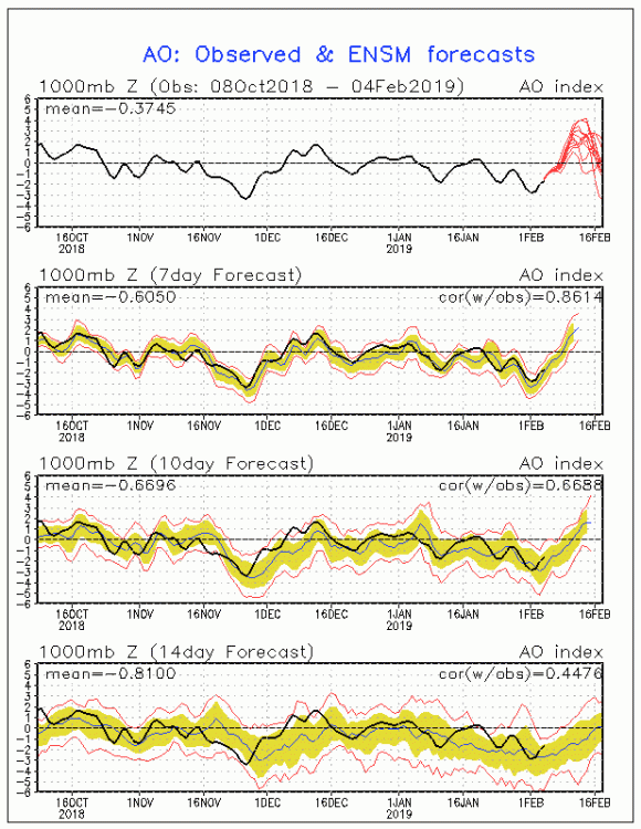
According to this, the AO will trend back to neutral/negative territory by the middle of the month. I’m more concerned about what the pacific does over the Atlantic. EPO can stay negative, with the PNA rising to neutral territory by the middle of February.
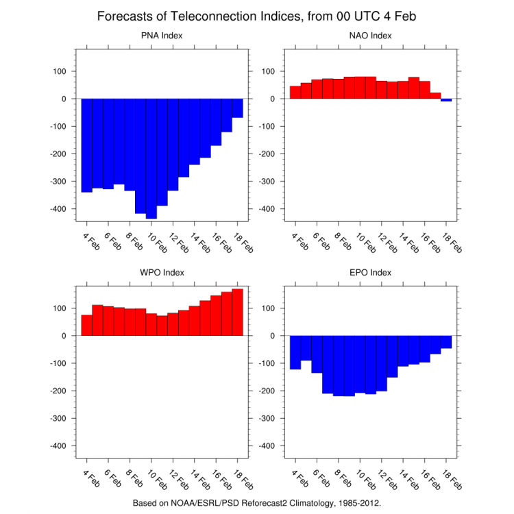
Look at the WPO, that’s what has been driving the raging PAC jet. It’s strong ++WPO and getting stronger throughout the period
-
4 minutes ago, Brian5671 said:
if the trough ends up like that, we'll have a bunch of cutters. No Atl Blocking is really killing us this year.
There hasn’t been any semblance of Atlantic blocking since November nor does it look like any will be forming through mid month and beyond
-
3 minutes ago, Snow88 said:
Negative epo
-
1 minute ago, snowman19 said:
The MJO going into phases 7 and 8 might not be what people think it is when there’s a weak stratospheric polar vortex like we have. Check this out:
Also, looks like the AO is going positive, the SSW did not workout as planned. From Dr. Butler:
-
48 minutes ago, TwcMan said:
Feels great out. The MJO looks great for later this month.
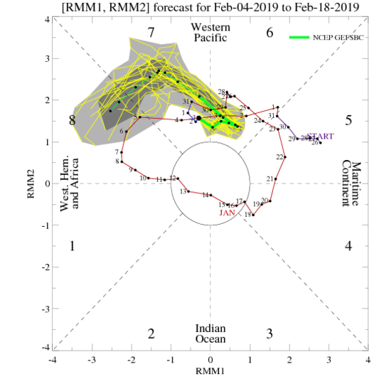
The MJO going into phases 7 and 8 might not be what people think it is when there’s a weak stratospheric polar vortex like we have. Check this out:
-
45 minutes ago, bluewave said:
Big MJO improvements today on the models. All the models now get to phase 8 by mid-February. Hopefully, we see the GEFS and CMC join the EPS with the more -EPO mid-February.
http://www.cpc.ncep.noaa.gov/products/precip/CWlink/MJO/CLIVAR/ecmm.shtml
HM just pointed it out but the real problem has been the raging ++WPO all winter long. It’s the reason the PAC jet has been an unrelenting firehose
-
8 minutes ago, Snow88 said:
Same here
You also notice the extreme -NAO bias it has had in the long range all winter? It keeps showing phantom -NAO’s that never advance forward in time. It’s done a terrible job on the Atlantic side. We haven’t been able to buy a -NAO block
-
1
-
-
49 minutes ago, Snow88 said:
Eps looks great from the 11th onward.
This might be the real deal if the woo cooperates and the mjo go into the favorable phase.
We’ve seen this show before a bunch of times this winter from the EPS, it’s one run so far. Let’s see if it actually holds or not this time and advances forward. I’m not holding my breath
-
1
-
1
-
-
13 minutes ago, NEG NAO said:
you are kidding me right ?

The FV3 sucks, horrible model. It’s honestly worse than the old GFS. And that map counts sleet and freezing rain as snow
-
1
-
1
-

February 2019 General Discussion and Observation Thread
in New York City Metro
Posted
EPS continues the RNA right through the last week of this month. It would appear the CanSIPS wasn’t so crazy after all with its prediction for February a couple of weeks ago