Blizzard of 93
-
Posts
12,945 -
Joined
-
Last visited
Content Type
Profiles
Blogs
Forums
American Weather
Media Demo
Store
Gallery
Everything posted by Blizzard of 93
-
Central PA Banter (Banter Less?) Thread
Blizzard of 93 replied to Itstrainingtime's topic in Upstate New York/Pennsylvania
Don’t give up. You are a good man & things can start to get better at any moment. -
I’ve seen forecasts the exact opposite of this for the next month… Who’s right? No one knows…
-
Central PA Winter 2024/2025
Blizzard of 93 replied to Voyager's topic in Upstate New York/Pennsylvania
30 in Marysville this morning. -
Central PA Winter 2024/2025
Blizzard of 93 replied to Voyager's topic in Upstate New York/Pennsylvania
I’m just speaking of snow totals. I think that some people are under the impression that Richmond or OCMD has had 50” this Winter… -
Central PA Winter 2024/2025
Blizzard of 93 replied to Voyager's topic in Upstate New York/Pennsylvania
The 18z Euro AI also trying to brew up a Winter storm chance on the 21st. -
Central PA Winter 2024/2025
Blizzard of 93 replied to Voyager's topic in Upstate New York/Pennsylvania
Here is a list of the seasonal snowfall totals for this season to date. i know that many think that this season really favored the Mid Atlantic for some reason. I really disagree with this notion. Someone please find a significant seasonal snowfall total to our south that shows much more snow than Harrisburg or Williamsport… The facts are that MD/DC did better than us for 2 events. The Gulf coastal South cashed in on the historic event that hit New Orleans & Pensacola. Then, the storm a couple of weeks ago hit Richmond, Norfolk & the Outer Banks. My point is that the bullseye has shifted around this Winter & no one specific area truly cashed in with large totals. -
Central PA Winter 2024/2025
Blizzard of 93 replied to Voyager's topic in Upstate New York/Pennsylvania
Lol, maybe in March we get the north trend. -
Central PA Winter 2024/2025
Blizzard of 93 replied to Voyager's topic in Upstate New York/Pennsylvania
The GFS has a Clipper chance on the 21st this run. -
Central PA Winter 2024/2025
Blizzard of 93 replied to Voyager's topic in Upstate New York/Pennsylvania
The 12z Canadian is trying to brew something wintry up on day 10. -
Something to watch maybe before we fully close the shades?
-
Central PA Winter 2024/2025
Blizzard of 93 replied to Voyager's topic in Upstate New York/Pennsylvania
The 0z Euro has a fantasy range snow chance this run, just 2 weeks away, Lol. I am hoping for just 1 more to track before we are truly done this season. -
Central PA Winter 2024/2025
Blizzard of 93 replied to Voyager's topic in Upstate New York/Pennsylvania
I’m so very sad to hear this news. I hope & pray that you will get the best treatment to beat this as soon as possible. Please keep us posted when you get the chance so we can see how you are doing. I will root on any snow chance possible, even in April or May, because I know it would bring you some joy. We will all be rooting for you & looking forward to you finding that @paweather 540 line approaching PA next Fall. Just like Jimmy V said, “Don’t give up…Don’t ever give up”. -
Central PA Winter 2024/2025
Blizzard of 93 replied to Voyager's topic in Upstate New York/Pennsylvania
Hi everyone! The Euro AI says we might not be done yet with 2 Winter storm chances between the 18th & 22nd. -
Central PA Winter 2024/2025
Blizzard of 93 replied to Voyager's topic in Upstate New York/Pennsylvania
.84 of rain in Marysville for the event. -
Central PA Winter 2024/2025
Blizzard of 93 replied to Voyager's topic in Upstate New York/Pennsylvania
Wow, 2 runs in a row… Hopefully it gets some company tonight! -
The GFS splits the systems next weekend, with one going to the north & one going out to the south.
-
Central PA Winter 2024/2025
Blizzard of 93 replied to Voyager's topic in Upstate New York/Pennsylvania
The GFS splits the systems next weekend, with one going to the north & one going out to the south. -
Central PA Winter 2024/2025
Blizzard of 93 replied to Voyager's topic in Upstate New York/Pennsylvania
The Canadian is still trying for next weekend. -
The Canadian is still trying for next weekend.
-
Central PA Winter 2024/2025
Blizzard of 93 replied to Voyager's topic in Upstate New York/Pennsylvania
Low of 17 in Marysville. Maybe my lowest temperature until next December? -
Central PA Winter 2024/2025
Blizzard of 93 replied to Voyager's topic in Upstate New York/Pennsylvania
The 12z Canadian was a little closer to getting the job done next weekend & shows snow into MD & Southern PA this run. -
Central PA Winter 2024/2025
Blizzard of 93 replied to Voyager's topic in Upstate New York/Pennsylvania
12z GFS looked promising for next weekend’s chance, but then does not gain enough latitude this run to bring any snow chance to PA this run. It still bears watching for a few more days. -
Central PA Winter 2024/2025
Blizzard of 93 replied to Voyager's topic in Upstate New York/Pennsylvania
Why do we always do wind so well…that never fails, Lol! -
Central PA Winter 2024/2025
Blizzard of 93 replied to Voyager's topic in Upstate New York/Pennsylvania
Good morning, the 6z GFS is still trying for next weekend. The 0z Euro & Canadian are keeping the system to our south at this range. I agree, we need @Bubbler86 back. Hopefully he’s just taking a break.
-
Central PA Winter 2024/2025
Blizzard of 93 replied to Voyager's topic in Upstate New York/Pennsylvania
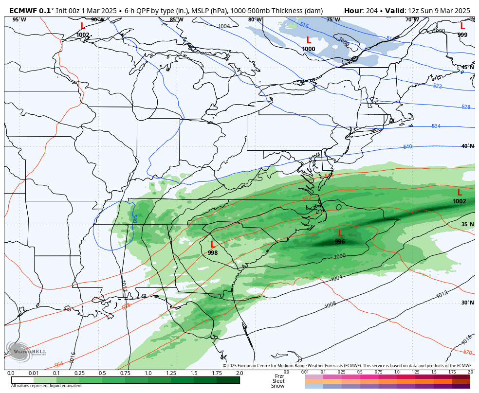
Thanks to @Weather Will For Next weekend’s chance… 6Z Euro AI....still tracking...