Blizzard of 93
-
Posts
13,024 -
Joined
-
Last visited
Content Type
Profiles
Blogs
Forums
American Weather
Media Demo
Store
Gallery
Everything posted by Blizzard of 93
-
Central PA Winter 2024/2025
Blizzard of 93 replied to Voyager's topic in Upstate New York/Pennsylvania
12z GFS looked promising for next weekend’s chance, but then does not gain enough latitude this run to bring any snow chance to PA this run. It still bears watching for a few more days. -
Central PA Winter 2024/2025
Blizzard of 93 replied to Voyager's topic in Upstate New York/Pennsylvania
Why do we always do wind so well…that never fails, Lol! -
Central PA Winter 2024/2025
Blizzard of 93 replied to Voyager's topic in Upstate New York/Pennsylvania
Good morning, the 6z GFS is still trying for next weekend. The 0z Euro & Canadian are keeping the system to our south at this range. I agree, we need @Bubbler86 back. Hopefully he’s just taking a break.
-
Central PA Winter 2024/2025
Blizzard of 93 replied to Voyager's topic in Upstate New York/Pennsylvania
Thanks to @Weather Will For Next weekend’s chance… 6Z Euro AI....still tracking... -
There appear to be timing differences on the 18z GEFS at this range with 2 main heavier precip windows between the 8th & 10th. Hopefully we get 1 more to track before we close the blinds for good. Here is the 4 day snow map for the period to show the timing differences at this range.
-
Agreed, the period from the 8th through the 10th certainly has potential.
-
Central PA Winter 2024/2025
Blizzard of 93 replied to Voyager's topic in Upstate New York/Pennsylvania
I remember him very well! Undertakerson (UTS) was one of the prolific posters in the old Accuweather forums. He lived just a few miles north of Harrisburg, so I looked forward to all of his posts because he was in my backyard. He knew the weather very well & was very good at pattern recognition. I only lurked there & then lurked at the early days of American. I finally decided to join in the posting fun here back in 2014. It would be great if UTS was still around & decided to post on here. -
Central PA Winter 2024/2025
Blizzard of 93 replied to Voyager's topic in Upstate New York/Pennsylvania
Extrapolating the 12z Canadian, that low out in Kansas looked promising if the run went out a couple more days… -
Central PA Winter 2024/2025
Blizzard of 93 replied to Voyager's topic in Upstate New York/Pennsylvania
12z GFS goes about it differently than the Euro AI, but it finds a way to snow on us early on the 10th. -
Central PA Winter 2024/2025
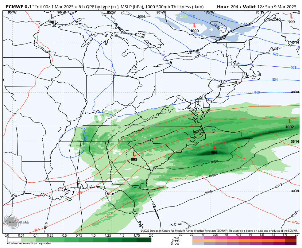
Blizzard of 93 replied to Voyager's topic in Upstate New York/Pennsylvania
The 6z Euro AI is on board for a late season chance around March 9th. It tracks a low from TN to near OCMD. Verbatim, temps are marginal for the LSV, but lots of time to sort out details if it even has a clue at this range. The AI has had a similar look for this time period for 3 straight runs. Hopefully we get one more to track. -
Central PA Winter 2024/2025
Blizzard of 93 replied to Voyager's topic in Upstate New York/Pennsylvania
This is great lunchtime reminiscing on PD2 back in 2003. This is my second place all time storm for my lifetime. On that Sunday morning that it started in the Harrisburg area, temps were in the single digits as a 1040+ High pressed down. It caused the initial large appendage of light to moderate snow to crawl north from MD into the LSV. Once you got in the precip shield, it didn’t stop snowing until around midday on Monday. I remember the snow intensity picked up as the day went on Sunday with the radar lit up the whole way back to at least Missouri. The low then tracked toward the Carolina coast & intensified Sunday night. The snow got heavier Sunday night into early Monday. Temperatures actually rose into the upper 20s as the coastal low took over. Then on Tuesday the upper low moved through, bringing a few more inches to top it off. What an epic, long duration, historic storm! -
Apparently that’s 2 runs in a row with this similar look on the AI for 3/9.
-
Central PA Winter 2024/2025
Blizzard of 93 replied to Voyager's topic in Upstate New York/Pennsylvania
Here is what the GFS delivered this run… If only… -
Central PA Winter 2024/2025
Blizzard of 93 replied to Voyager's topic in Upstate New York/Pennsylvania
You were clearly very tongue in cheek & quite funny. I was mentioned a few times & thought it was hilarious. We all have our tendencies & track records in here, but I realize that it was all in good fun. -
Central PA Winter 2024/2025
Blizzard of 93 replied to Voyager's topic in Upstate New York/Pennsylvania
Lol, this is a … wait for it… Weather board!!! We discuss current & potential upcoming weather. If you don’t like it, no one is making you post here… -
Central PA Winter 2024/2025
Blizzard of 93 replied to Voyager's topic in Upstate New York/Pennsylvania
He commented yesterday about the Caps in Mid Atlantic Banter thread. -
Central PA Winter 2024/2025
Blizzard of 93 replied to Voyager's topic in Upstate New York/Pennsylvania
Euro & GFS both show a Winter storm chance around March 8th. -
Central PA Winter 2024/2025
Blizzard of 93 replied to Voyager's topic in Upstate New York/Pennsylvania
Lol, Happy hour GFS says we only need to wait 16 days for our late season Winter Storm… -
Central PA Winter 2024/2025
Blizzard of 93 replied to Voyager's topic in Upstate New York/Pennsylvania
Same low here. -
Central PA Winter 2024/2025
Blizzard of 93 replied to Voyager's topic in Upstate New York/Pennsylvania
Last year was actually better in terms of snowfall so far at MDT. Last year MDT was at 18.7 for snow by now, which is where they finished. Last year should have actually ended up as a 20” plus season at MDT if that death band during the final event last February that hit me and areas along Blue Mountain to the east didn’t rob the rest of the LSV of the 3 to 6 that was forecast. Me & a few guys on the east shore of Harrisburg & out towards the Lehigh Valley ended up getting 6 to 8 while MDT was in between bands & only got less than 2. I’m hoping that MDT can get another 4 or 5 of snow this season to cross over the 20 inch mark, which would bring the total a little more respectability when we look back someday. We have certainly had the cold this season, but as you said, we have not yet had a signature storm to bring the snow total up. We have another 5 realistic weeks to score, so hopefully we can pad the snow stats a bit before it’s over. -
0z ensembles for week 2 all show that we should at least have chances as we roll through early March.
-
Central PA Winter 2024/2025
Blizzard of 93 replied to Voyager's topic in Upstate New York/Pennsylvania
0z ensembles for week 2 all show that we should at least have chances as we roll through early March. -
Central PA Winter 2024/2025
Blizzard of 93 replied to Voyager's topic in Upstate New York/Pennsylvania
Indeed, but I just want one more solid Warning level snow event before it’s all over. -
Central PA Winter 2024/2025
Blizzard of 93 replied to Voyager's topic in Upstate New York/Pennsylvania
6z GFS says to not put away the shovels & snowblowers. This run it shows 3 chances between March 4th & 10th. Maybe March will have a chance to make up for some of our February disappointment? -
Central PA Winter 2024/2025
Blizzard of 93 replied to Voyager's topic in Upstate New York/Pennsylvania
0z NAM & HRRR both have a coating to an inch or so of snow for the LSV tomorrow with the upper level low.