Blizzard of 93
-
Posts
13,024 -
Joined
-
Last visited
Content Type
Profiles
Blogs
Forums
American Weather
Media Demo
Store
Gallery
Everything posted by Blizzard of 93
-
Central PA Winter 25/26 Discussion and Obs
Blizzard of 93 replied to MAG5035's topic in Upstate New York/Pennsylvania
The January 8th/9th period is looking even more interesting. Great potential showing on the 12z Canadian & 18z GFS. -
Central PA Winter 25/26 Discussion and Obs
Blizzard of 93 replied to MAG5035's topic in Upstate New York/Pennsylvania
The 18z Euro still has the New Year’s Day clipper that gives many of us 1 to 2 inches of potential snow. -
Central PA Winter 25/26 Discussion and Obs
Blizzard of 93 replied to MAG5035's topic in Upstate New York/Pennsylvania
I’m ready for something like this 12z Euro run for 1/9 to verify. -
It’s a good look & the key is that it is sustainable.
-
Central PA Winter 25/26 Discussion and Obs
Blizzard of 93 replied to MAG5035's topic in Upstate New York/Pennsylvania
6z GFS has this moisture laden storm on the 6th this run. The potential period is going to be interesting to track. -
Central PA Winter 25/26 Discussion and Obs
Blizzard of 93 replied to MAG5035's topic in Upstate New York/Pennsylvania
Here is the 0z EPS look for the day 10 to 15 period. -
Yes indeed, here is the 0z EPS look for the day 10 to 15 period.
-
Central PA Winter 25/26 Discussion and Obs
Blizzard of 93 replied to MAG5035's topic in Upstate New York/Pennsylvania
The first half of January looks to bring this potential… -
Central PA Winter 25/26 Discussion and Obs
Blizzard of 93 replied to MAG5035's topic in Upstate New York/Pennsylvania
Next up for a light snow chance is another Clipper potential around New Year’s Day. -
Central PA Winter 25/26 Discussion and Obs
Blizzard of 93 replied to MAG5035's topic in Upstate New York/Pennsylvania
The upcoming advertised pattern during the first half of January says “buckle up”! -
Central PA Winter 25/26 Discussion and Obs
Blizzard of 93 replied to MAG5035's topic in Upstate New York/Pennsylvania
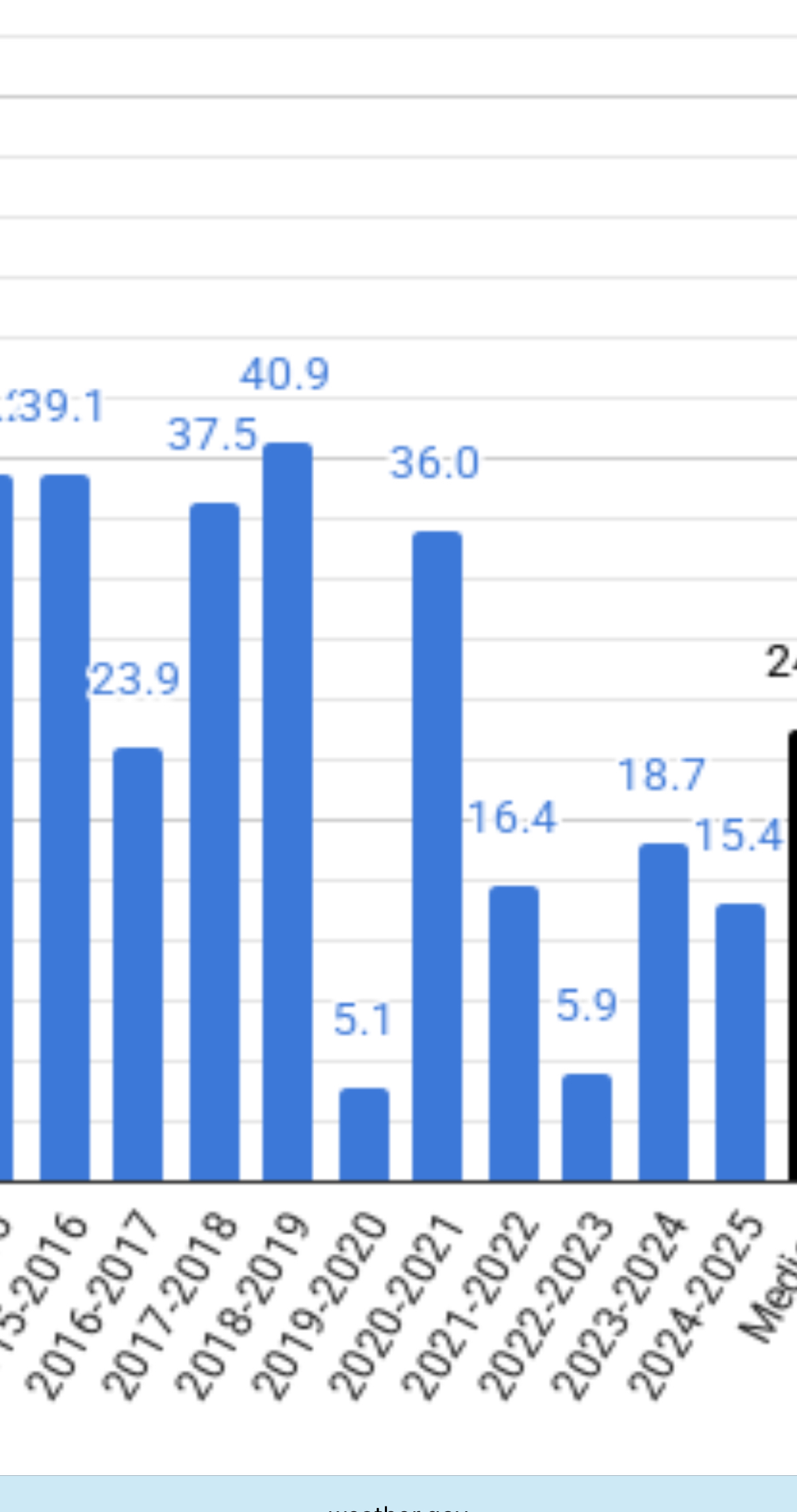
ABC-27 just showed on their news some information in regard to our local Winter weather. They had a graphic that said 8 of the last 10 Winters had below normal snowfall. I’m assuming they are using MDT stats. CTP is showing that only 6 of the last 10 Winter seasons had below normal snow at MDT. Maybe they are only using Dec to Feb which could skew it by not including November & March/April snow? Below are the official seasonal numbers from CTP’s website for MDT seasonal snow for the last 10 seasons.
-
Central PA Winter 25/26 Discussion and Obs
Blizzard of 93 replied to MAG5035's topic in Upstate New York/Pennsylvania
My temp is still 32. Icy Winter wonderland out there is showing beautiful scenery. -
Central PA Winter 25/26 Discussion and Obs
Blizzard of 93 replied to MAG5035's topic in Upstate New York/Pennsylvania
Models continue to look active with chances during the first 10 days of January. -
Central PA Winter 25/26 Discussion and Obs
Blizzard of 93 replied to MAG5035's topic in Upstate New York/Pennsylvania
Sleet covered roads at least make it look more wintry. Looks to be about half an inch of sleet out there on top of a glaze of freezing rain. Freezing drizzle later should make this a real treat to remove in the morning from the sidewalk. -
Central PA Winter 25/26 Discussion and Obs
Blizzard of 93 replied to MAG5035's topic in Upstate New York/Pennsylvania
Puking sleet right in Marysville now after a period a freezing rain. Absolute skating rink out there now. Temp 27 Dew point 24 -
Central PA Winter 25/26 Discussion and Obs
Blizzard of 93 replied to MAG5035's topic in Upstate New York/Pennsylvania
Heavier band looks to be approaching the western LSV in Adams, Cumberland & Perry on the march due east. -
Central PA Winter 25/26 Discussion and Obs
Blizzard of 93 replied to MAG5035's topic in Upstate New York/Pennsylvania
Sleet & Freezing rain mix to start in Marysville transitioned to moderate sleet. The cars are already encrusted in Ice & getting sleet covered. Temp 28 Dew point 20 -
Central PA Winter 25/26 Discussion and Obs
Blizzard of 93 replied to MAG5035's topic in Upstate New York/Pennsylvania
MDT dew point is currently 9. Lots of cold air in place, so say it with me… “air temp will drop when precipitation begins”. Lol! -
Central PA Winter 25/26 Discussion and Obs
Blizzard of 93 replied to MAG5035's topic in Upstate New York/Pennsylvania
Look at your dew point………….. -
Central PA Winter 25/26 Discussion and Obs
Blizzard of 93 replied to MAG5035's topic in Upstate New York/Pennsylvania
MDT is above normal for the season to date at 5.0” -
The Op runs are showing a lot of activity in the first 10 days of January with storms actually approaching from the south & west instead of the north. We will likely have the chance to win & lose, but I think it will be better than tracking weak Clippers that the previous few weeks have brought us.
-
Central PA Winter 25/26 Discussion and Obs
Blizzard of 93 replied to MAG5035's topic in Upstate New York/Pennsylvania
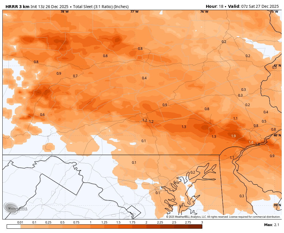
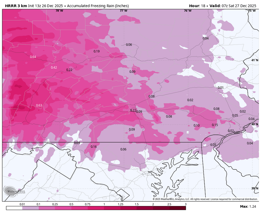
Latest HRRR brings over 1 inch of sleet to Harrisburg & Lancaster with a tenth or 2 of freezing rain on top.
-
Central PA Winter 25/26 Discussion and Obs
Blizzard of 93 replied to MAG5035's topic in Upstate New York/Pennsylvania
Additionally, most of us are slightly above normal snow for the season to date as well. -
Central PA Winter 25/26 Discussion and Obs
Blizzard of 93 replied to MAG5035's topic in Upstate New York/Pennsylvania
I didn’t realize that was good old Steve D. I would love for him to be right for back here in our area, but I don’t see any of us getting near 4 or 6 inches. Maybe we get 1 or 2 of slop. -
Central PA Winter 25/26 Discussion and Obs
Blizzard of 93 replied to MAG5035's topic in Upstate New York/Pennsylvania
Well, I remember last year when for 2 or 3 weeks in late January into mid February, all 3 global ensemble models had our region consistently near 10 inches or more of snow. Ground truth turned out to be a light event or two. Point is, I no longer get excited about the 15 day ensemble totals until there is a specific threat to track. They should mainly be used for pattern recognition & identifying windows of opportunity in my opinion.