

Blizzard of 93
-
Posts
13,024 -
Joined
-
Last visited
Content Type
Profiles
Blogs
Forums
American Weather
Media Demo
Store
Gallery
Everything posted by Blizzard of 93
-
Central PA Winter 25/26 Discussion and Obs
Blizzard of 93 replied to MAG5035's topic in Upstate New York/Pennsylvania
Let’s go!!! I am happy you are back on here for sure! -
Central PA Winter 25/26 Discussion and Obs
Blizzard of 93 replied to MAG5035's topic in Upstate New York/Pennsylvania
It will be interesting to see if they start changing their tune with their update this evening. -
Central PA Winter 25/26 Discussion and Obs
Blizzard of 93 replied to MAG5035's topic in Upstate New York/Pennsylvania
The Euro is a miss for next weekend at this time. Nothing close this run for the second event on the 12z Euro. -
The good difference in the 12z Euro vs. the 0z Euro last night shows well in the 48 hr. total precipitation through Friday early afternoon. Quite the positive jump.
-
Central PA Winter 25/26 Discussion and Obs
Blizzard of 93 replied to MAG5035's topic in Upstate New York/Pennsylvania
The good difference in the 12z Euro vs. the 0z Euro last night shows well in the 48 hr. total precipitation through Friday early afternoon. Quite the positive jump. -
Central PA Winter 25/26 Discussion and Obs
Blizzard of 93 replied to MAG5035's topic in Upstate New York/Pennsylvania
Yes indeed, good step by the 12z Euro for Thursday. -
Central PA Winter 25/26 Discussion and Obs
Blizzard of 93 replied to MAG5035's topic in Upstate New York/Pennsylvania
Thanks, as always, I’m just showing potential chances! As @Itstrainingtime says, we can’t shovel potential… but it’s great to see we have chances to score next week. -
Central PA Winter 25/26 Discussion and Obs
Blizzard of 93 replied to MAG5035's topic in Upstate New York/Pennsylvania
Please if only… Lol! -
Central PA Winter 25/26 Discussion and Obs
Blizzard of 93 replied to MAG5035's topic in Upstate New York/Pennsylvania
12z GFS says we could go 2 for 2 ! Second storm next Sunday this run produces another Warning level chance. This snow is ONLY for the Sunday storm chance. -
Central PA Winter 25/26 Discussion and Obs
Blizzard of 93 replied to MAG5035's topic in Upstate New York/Pennsylvania
@paweather would only need to chase to see @mitchnick or @anotherman got the jackpot this run, lol! -
Central PA Winter 25/26 Discussion and Obs
Blizzard of 93 replied to MAG5035's topic in Upstate New York/Pennsylvania
12z GFS is wow… If only…please please, lol! -
Yup… if only…
-
Continues at 141
-
Heavy snow at 138
-
-
Central PA Winter 25/26 Discussion and Obs
Blizzard of 93 replied to MAG5035's topic in Upstate New York/Pennsylvania
We don’t know any outcome, that’s the main thing. We have 2 chances, results are tbd. -
Central PA Winter 25/26 Discussion and Obs
Blizzard of 93 replied to MAG5035's topic in Upstate New York/Pennsylvania
Lol, waaaaaayyyyyy toooooo sooooon to be saying something like that! We have 2 chances in the next 9 days. Stay tuned to see if we go 0-2, 1-1 or 2-0 ! Lots of twists & turns to be determined… -
Central PA Winter 25/26 Discussion and Obs
Blizzard of 93 replied to MAG5035's topic in Upstate New York/Pennsylvania
The 6z GFS for the 15th still has a moderate event for the LSV, but is nothing like its 0z run. Many of us in the LSV would still sign for this 6z version. -
Central PA Winter 25/26 Discussion and Obs
Blizzard of 93 replied to MAG5035's topic in Upstate New York/Pennsylvania
Unfortunately there was no other model support for the 0z GFS. Still something to track, but the GfS was all alone at 0z. -
Central PA Winter 25/26 Discussion and Obs
Blizzard of 93 replied to MAG5035's topic in Upstate New York/Pennsylvania
0z GFS went crazy for the Thursday chance… Maybe there’s still a chance to reel in both chances next week?! -
Central PA Winter 25/26 Discussion and Obs
Blizzard of 93 replied to MAG5035's topic in Upstate New York/Pennsylvania
18z GFS is a long duration Warning level event this run for next Sunday into Monday. -
Absolutely, 18z GFS is a long duration Warning level event this run.
-
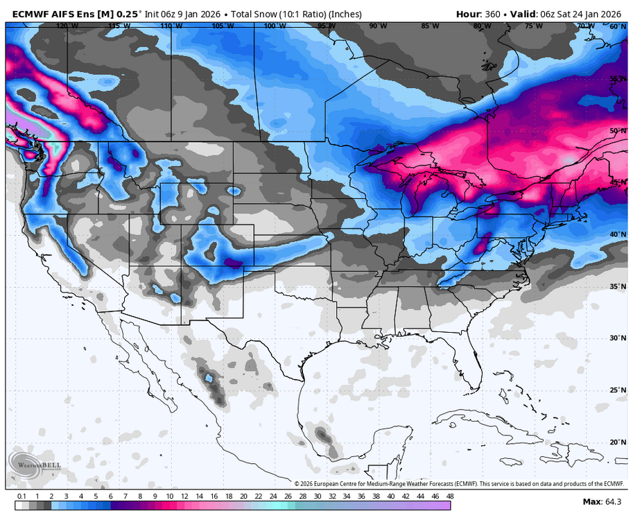
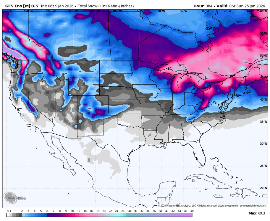
0z EPS, 6z GEFS & 6z AI EPS show the potential for the upcoming period.
-
Central PA Winter 25/26 Discussion and Obs
Blizzard of 93 replied to MAG5035's topic in Upstate New York/Pennsylvania
Lol, My old handbook says to take the GFS for the first chance & the 0z Euro for the one a few days later. -
Lol, My old handbook says to take the GFS for the first chance & the 0z Euro for the one a few days later.


