Blizzard of 93
-
Posts
13,024 -
Joined
-
Last visited
Content Type
Profiles
Blogs
Forums
American Weather
Media Demo
Store
Gallery
Everything posted by Blizzard of 93
-
Central PA Winter 25/26 Discussion and Obs
Blizzard of 93 replied to MAG5035's topic in Upstate New York/Pennsylvania
Eastern third of PA might be in play for a little snow from the coastal going by overnight model trends. It will be interesting to watch the model trends today to see if any of us can score back to back light events this weekend. -
Central PA Winter 25/26 Discussion and Obs
Blizzard of 93 replied to MAG5035's topic in Upstate New York/Pennsylvania
It’s moving more southwest to northeast, but western LSV will not do as well as those further east and northeast. -
Central PA Winter 25/26 Discussion and Obs
Blizzard of 93 replied to MAG5035's topic in Upstate New York/Pennsylvania
Snow is underway in Marysville. Light dusting on the car tops already. -
Central PA Winter 25/26 Discussion and Obs
Blizzard of 93 replied to MAG5035's topic in Upstate New York/Pennsylvania
NAM twins are looking good for tomorrow am. -
Hi! Lol, We do have a Central PA thread that includes many posters from York, Lebanon, Dauphin & Lancaster. Most of us that post there regularly are from southern PA. @mitchnick posts there sometimes. You are welcome to come home as well anytime!
-
Central PA Winter 25/26 Discussion and Obs
Blizzard of 93 replied to MAG5035's topic in Upstate New York/Pennsylvania
Lol, we posted at the same time! Here is to scoring snow tomorrow! -
Central PA Winter 25/26 Discussion and Obs
Blizzard of 93 replied to MAG5035's topic in Upstate New York/Pennsylvania
The LSV has beef Advised for tomorrow! Winter Weather Advisory URGENT - WINTER WEATHER MESSAGE National Weather Service State College PA 805 PM EST Fri Jan 16 2026 PAZ057>059-065-066-171700- /O.EXB.KCTP.WW.Y.0004.260117T1000Z-260117T1700Z/ Dauphin-Schuylkill-Lebanon-York-Lancaster- Including the cities of Lebanon, Pottsville, Harrisburg, Lancaster, York, and Hershey 805 PM EST Fri Jan 16 2026 ...WINTER WEATHER ADVISORY IN EFFECT FROM 5 AM TO NOON EST SATURDAY... * WHAT...Periods of snow expected. Possibly mixed with some freezing rain and sleet. Total snow accumulations 1 to 3 inches. Ice accumulation around a trace. * WHERE...Dauphin, Lancaster, Lebanon, Schuylkill, and York Counties. * WHEN...From 5 AM to noon EST Saturday. * IMPACTS...Plan on slippery road conditions. -
Central PA Winter 25/26 Discussion and Obs
Blizzard of 93 replied to MAG5035's topic in Upstate New York/Pennsylvania
CTP “Expected Snow” for tomorrow. -
Central PA Winter 25/26 Discussion and Obs
Blizzard of 93 replied to MAG5035's topic in Upstate New York/Pennsylvania
It’s Friday…so…. here is the combined 6z GFS snow map through the end of January just for fun & to show the potential if it all would come together… if only…! -
Central PA Winter 25/26 Discussion and Obs
Blizzard of 93 replied to MAG5035's topic in Upstate New York/Pennsylvania
Super active 6z GFS run with multiple Winter storm threats It features a Next Friday snow chance. Then Next Sunday has a snow to mix back to snow chance. The the middle of the following week it has a coastal that just brushes us, but has high upside potential. What a run! -
Central PA Winter 25/26 Discussion and Obs
Blizzard of 93 replied to MAG5035's topic in Upstate New York/Pennsylvania
The 0z Euro had 3 light to moderate events from late next week through the end of the month. -
Central PA Winter 25/26 Discussion and Obs
Blizzard of 93 replied to MAG5035's topic in Upstate New York/Pennsylvania
The old NAM agreeing with the Euro rule is in play for us tomorrow for the chance of some light snow. -
Central PA Winter 25/26 Discussion and Obs
Blizzard of 93 replied to MAG5035's topic in Upstate New York/Pennsylvania
I agree with the cold part, but at least through late January there should be more moisture laden storms with at least moderate Winter precipitation potential. -
Central PA Winter 25/26 Discussion and Obs
Blizzard of 93 replied to MAG5035's topic in Upstate New York/Pennsylvania
Combined 12z Euro snow map for all 3 events by the end of day 15 is impressive for the whole region. -
Central PA Winter 25/26 Discussion and Obs
Blizzard of 93 replied to MAG5035's topic in Upstate New York/Pennsylvania
The 12z Euro was a beautiful run showing 3 potential Winter storm chances between next weekend & the end of January. Looks like a pattern of storms & rumors of storms… -
Central PA Winter 25/26 Discussion and Obs
Blizzard of 93 replied to MAG5035's topic in Upstate New York/Pennsylvania
Happy Birthday! Let’s reel in some snow this month to celebrate! -
Central PA Winter 25/26 Discussion and Obs
Blizzard of 93 replied to MAG5035's topic in Upstate New York/Pennsylvania
Saturday- still a chance of light snow on most models. Monday- Most models have the coastal too far east to impact us, but still need to track for another day or two. End of Next week to end of month- active with moisture laden storms & cold air around. The 0z Euro had 2 Winter Storm chances in this window. All of the ensembles have been ramping up snow amounts for this period. The pattern & telleconnections look to be in a good place to support our chances. -
Central PA Winter 25/26 Discussion and Obs
Blizzard of 93 replied to MAG5035's topic in Upstate New York/Pennsylvania
It will be fascinating to watch this unfold in the next couple of days. Hopefully the Euro takes another positive step tonight. -
Central PA Winter 25/26 Discussion and Obs
Blizzard of 93 replied to MAG5035's topic in Upstate New York/Pennsylvania
3k NAM is delivering a solid Advisory event to the LSV on Saturday as well At the end of its 60 hour run. -
Central PA Winter 25/26 Discussion and Obs
Blizzard of 93 replied to MAG5035's topic in Upstate New York/Pennsylvania
Good, hopefully the rest of 0z is similar. -
Central PA Winter 25/26 Discussion and Obs
Blizzard of 93 replied to MAG5035's topic in Upstate New York/Pennsylvania
18z GEFS also likes the late next week potential. -
Central PA Winter 25/26 Discussion and Obs
Blizzard of 93 replied to MAG5035's topic in Upstate New York/Pennsylvania
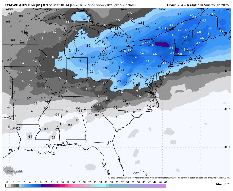
Really strong signal for this range on the 18z AI EPS for Next weekend.
-
Central PA Winter 25/26 Discussion and Obs
Blizzard of 93 replied to MAG5035's topic in Upstate New York/Pennsylvania
18z RGEM & NAM were interested in a Saturday light event as well for us. -
Central PA Winter 25/26 Discussion and Obs
Blizzard of 93 replied to MAG5035's topic in Upstate New York/Pennsylvania
I’m most interested short term in the Saturday chance at this point. The coastal chance on Sunday will likely be too far to our south & east to impact most of CTP, unless we see significant changes the next few days. The 18z Euro gives many of us near 1 inch on Saturday. -
Central PA Winter 25/26 Discussion and Obs
Blizzard of 93 replied to MAG5035's topic in Upstate New York/Pennsylvania
After reviewing the overnight models, there is still a lot of uncertainty for the period from late tonight through Monday am. There are a few northern stream systems dropping down into our region, but impacts appear to just be minor to possibly nothing at this time. We will need to keep tracking to see if any of these minor systems over the next few days can get their act together to produce a widespread light snow event. If not, the period from later next week & beyond looks more active with Winter storm chances through the end of January.