Blizzard of 93
-
Posts
13,024 -
Joined
-
Last visited
Content Type
Profiles
Blogs
Forums
American Weather
Media Demo
Store
Gallery
Everything posted by Blizzard of 93
-
Central PA Winter 25/26 Discussion and Obs
Blizzard of 93 replied to MAG5035's topic in Upstate New York/Pennsylvania
The 12z EPS & 12z Canadian ensemble in the day 10 to 15 period look very workable to me. I have no interest in freezing the orange groves while we have below zero temps. Last year a frigid 2 weeks in late January gave us “congrats Carolinas” & “congrats Gulf coast” when they snowed while we froze. I think many of us would welcome a pattern of just cold enough with chances to score snow. Bring on some moisture laden storms & let the chips fall during prime snow climo season. -
The 12z EPS & 12z Canadian ensemble in the day 10 to 15 period look very workable to me. I have no interest in freezing the orange groves while we have below zero temps. Last year a frigid 2 weeks in late January gave us “congrats Carolinas” & “congrats Gulf coast” when they snowed while we froze. I think many of us would welcome a pattern of just cold enough with chances to score snow. Bring on some moisture laden storms & let the chips fall during prime snow climo season.
-
12z Canadian ends on day 10 with widespread cold.
-
The 12z Canadian has the trough in the east again by the 11th.
-
Central PA Winter 25/26 Discussion and Obs
Blizzard of 93 replied to MAG5035's topic in Upstate New York/Pennsylvania
12z Canadian ends on day 10 with widespread cold. -
Central PA Winter 25/26 Discussion and Obs
Blizzard of 93 replied to MAG5035's topic in Upstate New York/Pennsylvania
The 12z Canadian has the trough in the east again by the 11th with a light snow chance this run. -
Central PA Winter 25/26 Discussion and Obs
Blizzard of 93 replied to MAG5035's topic in Upstate New York/Pennsylvania
Maybe the first 10 days or so are boring with a brief warm up for around 5 days. -
Central PA Winter 25/26 Discussion and Obs
Blizzard of 93 replied to MAG5035's topic in Upstate New York/Pennsylvania
Usually trough in Europe & trough near Japan corresponds with a trough in the eastern US, but there is usually a brief lag. -
It should be a reminder that anytime there’s been a chance for snowflakes that it has happened just about every time. I think that means a season is going well…
-
Central PA Winter 25/26 Discussion and Obs
Blizzard of 93 replied to MAG5035's topic in Upstate New York/Pennsylvania
Maybe yet another surprise dusting is on the way tonight? -
Central PA Winter 25/26 Discussion and Obs
Blizzard of 93 replied to MAG5035's topic in Upstate New York/Pennsylvania
18z Euro also showed a dusting overnight for many of us. -
Central PA Winter 25/26 Discussion and Obs
Blizzard of 93 replied to MAG5035's topic in Upstate New York/Pennsylvania
The 0z RGEM is one of the only models to show the LSV getting .5 to 1 inch of snow by tomorrow am from this Clipper. -
Central PA Winter 25/26 Discussion and Obs
Blizzard of 93 replied to MAG5035's topic in Upstate New York/Pennsylvania
Happy New Year again to all! I noticed @Bubbler86 posted some Obs during a recent event in the Mid Atlantic thread. With it being the time of year for fresh starts & new beginnings, I would love for @Bubbler86 to start posting on here again for the heart of Winter & beyond. We miss you Bubbler, please come back! -
Central PA Winter 25/26 Discussion and Obs
Blizzard of 93 replied to MAG5035's topic in Upstate New York/Pennsylvania
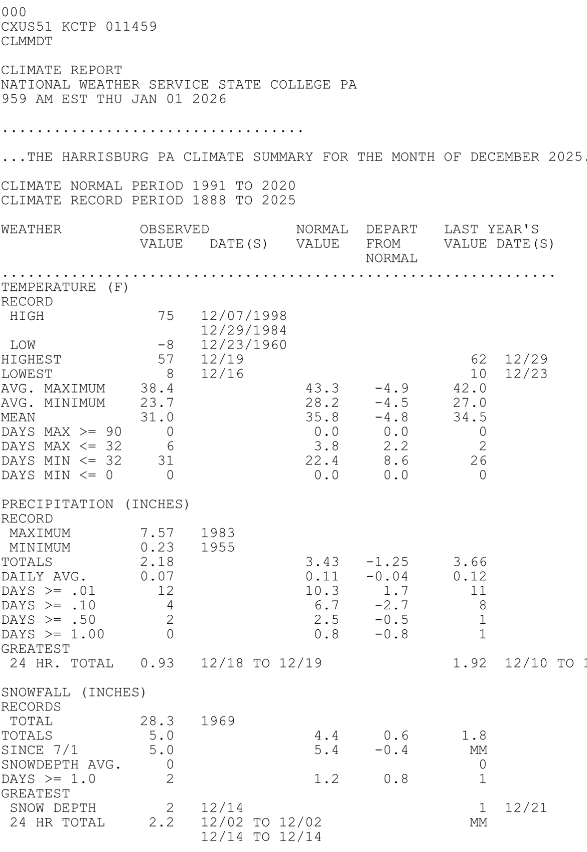
December is now in the books at MDT. -4.8 temperature departure 5.0” snow which is slightly above the 4.4 December average. Not a bad start to the Winter. Hopefully we have more chances to score snow as Winter continues.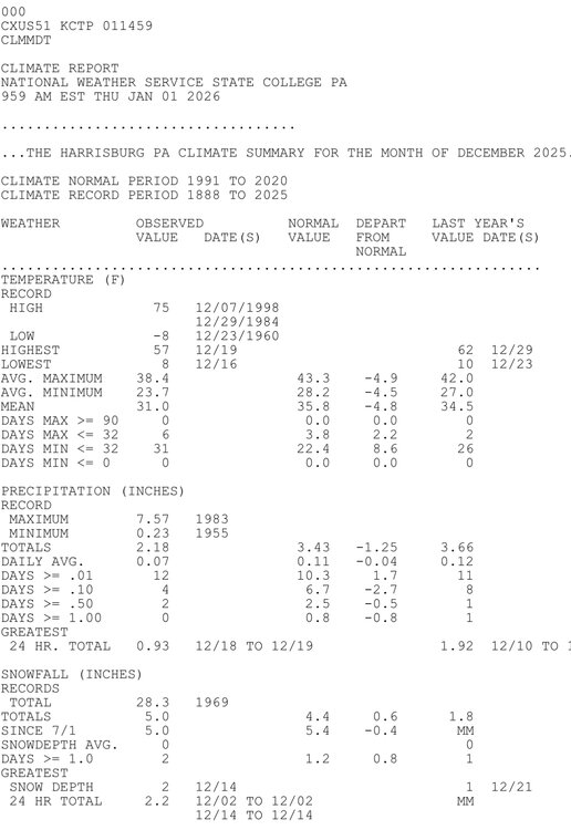
-
This season has especially proven to not be too concerned beyond week 2 or 3, and even then, changes have been happening in day 7 to 10. Just yesterday the punters were out until after mid January, but now we might be getting back into business in 10 days or so.
-
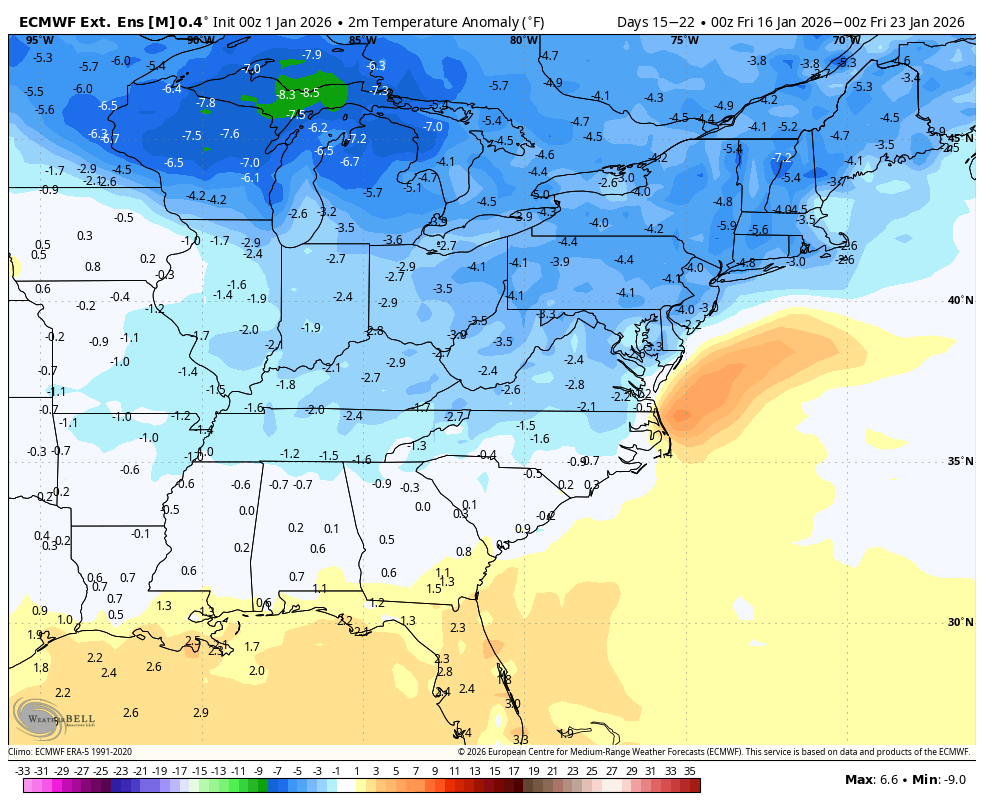
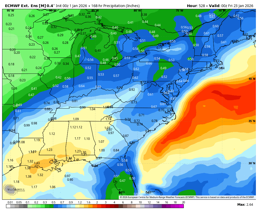
Speaking of week 3 on the latest Euro Weeklies… Today’s run for week 3 shows a decent general look, below normal temperatures & a good amount of precip.


-
Weeklies have generally proved to be about worthless, especially beyond week 3. Heck, we keep seeing changes for week 2.
-
2 out of 3 ain’t bad… Also, @CAPE posted a good look on the GEFS a little earlier for around the 12th.
-
Central PA Winter 25/26 Discussion and Obs
Blizzard of 93 replied to MAG5035's topic in Upstate New York/Pennsylvania
12z EPS & 12z Canadian ensemble also are indicating that we should be back in the tracking business in the day 10 to 15 period. -
12z EPS & 12z Canadian ensemble also are indicating that we should be back in the tracking business in the day 10 to 15 period.
-
Central PA Winter 25/26 Discussion and Obs
Blizzard of 93 replied to MAG5035's topic in Upstate New York/Pennsylvania
Same plan here! Watching the parade & football later on. -
Central PA Winter 25/26 Discussion and Obs
Blizzard of 93 replied to MAG5035's topic in Upstate New York/Pennsylvania
Agreed, that’s what I’m going with as well. Unfortunately I slept through the squall, but it was great to wake up to this first day of the year! Happy New Year everyone! -
Central PA Winter 25/26 Discussion and Obs
Blizzard of 93 replied to MAG5035's topic in Upstate New York/Pennsylvania
Here are CTP’s thoughts for tomorrow. By the mid to late afternoon (New Years Eve), a wave of low pressure will drift eastward across the Great Lakes, and drag an Arctic front south through the Commonwealth. Underneath a favorable left exit region of an upper jet, this front could produce a threat of snow squalls late Wednesday evening into the New Year. Current expectation is that the front and associated snow squall threat will move into northwest PA in the 6-8PM timeframe and then race southeast, crossing the I-99 corridor between 10PM and midnight and then getting into the Lower Susquehanna Valley between midnight and 2AM. Anyone planning to travel for the New Year should be prepared for the risk of snow squalls. If a Snow Squall Warning is issued, delay travel or exit the highway at the next opportunity. -
Central PA Winter 25/26 Discussion and Obs
Blizzard of 93 replied to MAG5035's topic in Upstate New York/Pennsylvania
It is relentless! -
Central PA Winter 25/26 Discussion and Obs
Blizzard of 93 replied to MAG5035's topic in Upstate New York/Pennsylvania
A few bouts of light snow showers on & off the last few hours between Harrisburg & Marysville. Oh, it’s also windy here. I’m not looking forward to finding my trash can tomorrow am, lol!