Blizzard of 93
-
Posts
13,024 -
Joined
-
Last visited
Content Type
Profiles
Blogs
Forums
American Weather
Media Demo
Store
Gallery
Everything posted by Blizzard of 93
-
Central PA Winter 25/26 Discussion and Obs
Blizzard of 93 replied to MAG5035's topic in Upstate New York/Pennsylvania
I like seeing the warmer temperatures in southeast PA, such as the 40 at Philly International at the 9 pm. Ob. The temperature contrast with colder temps in NW PA could help us in the LSV with the better precipitation rates eventually. -
Central PA Winter 25/26 Discussion and Obs
Blizzard of 93 replied to MAG5035's topic in Upstate New York/Pennsylvania
I’m enjoying it as well! Beautiful Winter night. -
Central PA Winter 25/26 Discussion and Obs
Blizzard of 93 replied to MAG5035's topic in Upstate New York/Pennsylvania
The storm is on track for a solid Advisory event for the majority of the LSV. -
Central PA Winter 25/26 Discussion and Obs
Blizzard of 93 replied to MAG5035's topic in Upstate New York/Pennsylvania
Lol, it’s still snowing back to Cincinnati, OH. Radar looks great. -
Central PA Winter 25/26 Discussion and Obs
Blizzard of 93 replied to MAG5035's topic in Upstate New York/Pennsylvania
Light snow in Marysville with car tops & grass dusted. Fluff factor looks good on the car tops which should help when rates pick up. Temp is 32. -
Central PA Winter 25/26 Discussion and Obs
Blizzard of 93 replied to MAG5035's topic in Upstate New York/Pennsylvania
18z Euro with its best run yet for the event for the Harrisburg area with bringing 3 inches of Non-Advised snow tonight.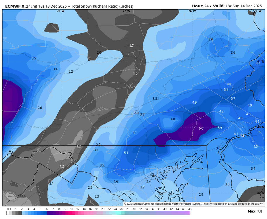
-
Central PA Winter 25/26 Discussion and Obs
Blizzard of 93 replied to MAG5035's topic in Upstate New York/Pennsylvania
Lol, Lanco is looking good for the event. -
Central PA Winter 25/26 Discussion and Obs
Blizzard of 93 replied to MAG5035's topic in Upstate New York/Pennsylvania
18z RGEM -
Central PA Winter 25/26 Discussion and Obs
Blizzard of 93 replied to MAG5035's topic in Upstate New York/Pennsylvania
Indeed -
Central PA Winter 25/26 Discussion and Obs
Blizzard of 93 replied to MAG5035's topic in Upstate New York/Pennsylvania
It’s a start, but they need to add Dauphin & Skook… I’m not sure they are aware that most of the population of Dauphin county is in the southern half… They just updated with this: NEAR TERM /UNTIL 6 AM SUNDAY MORNING/... Mid afternoon changes. Some model guidance has a bit heavier QPF across the northern edge of where we had an advisory out for the far SE counties, thus adding in a couple more counties into the advisory. -
Central PA Winter 25/26 Discussion and Obs
Blizzard of 93 replied to MAG5035's topic in Upstate New York/Pennsylvania
What’s wrong with an Advisory for 1 to 3 with a few spots maybe seeing 4 ? I don’t understand their reasoning. We don’t live in the mountains down here, so the message needs to be clear for average people that don’t pay close attention to the weather. Likely we’ll get an Advisory for Dauphin, Lebanon & Skook as the event is underway, which would be too late to help people with travel decisions. -
Central PA Winter 25/26 Discussion and Obs
Blizzard of 93 replied to MAG5035's topic in Upstate New York/Pennsylvania
A few more counties have been graced with a HWO… this Not good enough messaging… Most People need to see at least an Advisory to consider not going out or altering their plans, especially on a Saturday night near the holidays… Hazardous Weather Outlook Hazardous Weather Outlook National Weather Service State College PA 245 PM EST Sat Dec 13 2025 PAZ057>059-063-064-141945- Dauphin-Schuylkill-Lebanon-Cumberland-Adams- 245 PM EST Sat Dec 13 2025 This Hazardous Weather Outlook is for central Pennsylvania. .DAY ONE...This afternoon and tonight. Brief heavy snow is possible this evening and early tonight. Most locations will pick up 1 to 2 inches, but spot amounts of 3 or 4 are possible, especially on the higher elevations. .DAYS TWO THROUGH SEVEN...Sunday through Friday. The probability for widespread hazardous weather is low. -
Central PA Winter 25/26 Discussion and Obs
Blizzard of 93 replied to MAG5035's topic in Upstate New York/Pennsylvania
I’m happy that our Lancaster & York posters seem to be in a good spot for this one. MDT should be able to add to the seasonal tally as well. -
Central PA Winter 25/26 Discussion and Obs
Blizzard of 93 replied to MAG5035's topic in Upstate New York/Pennsylvania
18z National Blend of Models.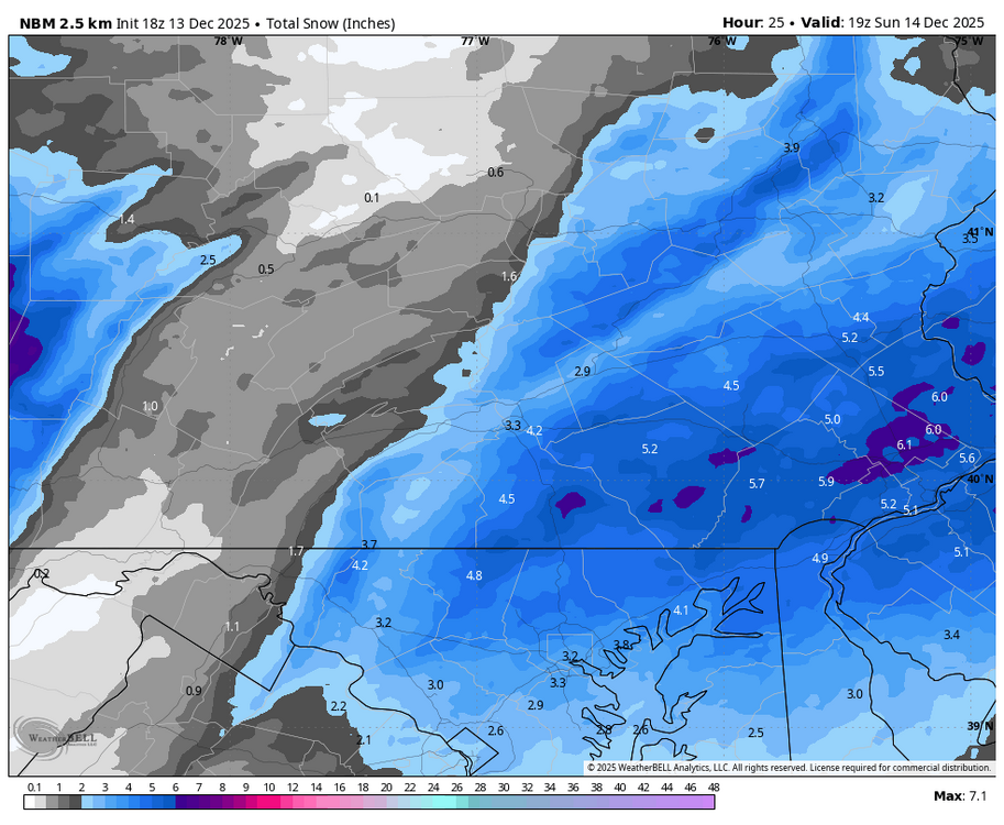
-
Central PA Winter 25/26 Discussion and Obs
Blizzard of 93 replied to MAG5035's topic in Upstate New York/Pennsylvania
I think CTP & local news in the LSV need to update their forecasts based on short term modeling last night & today. I’m seeing a lot of “coating to an inch or two” forecasts. Most model have a good chunk of the LSV in the 2 to 4 inch range. This of course is a busy time of year with people out shopping & holiday parties, etc. The media & CTP need to put better messaging out today in my opinion which could help keep some people safe. -
Central PA Winter 25/26 Discussion and Obs
Blizzard of 93 replied to MAG5035's topic in Upstate New York/Pennsylvania
It should just be a matter of time until CTP expands the Advisory At least into Dauphin, Lebanon & Skook. -
Central PA Winter 25/26 Discussion and Obs
Blizzard of 93 replied to MAG5035's topic in Upstate New York/Pennsylvania
Great write up! But I must ask the ageless running joke on the weather boards… Lol… ”How much for Philly?!” -
Central PA Winter 25/26 Discussion and Obs
Blizzard of 93 replied to MAG5035's topic in Upstate New York/Pennsylvania
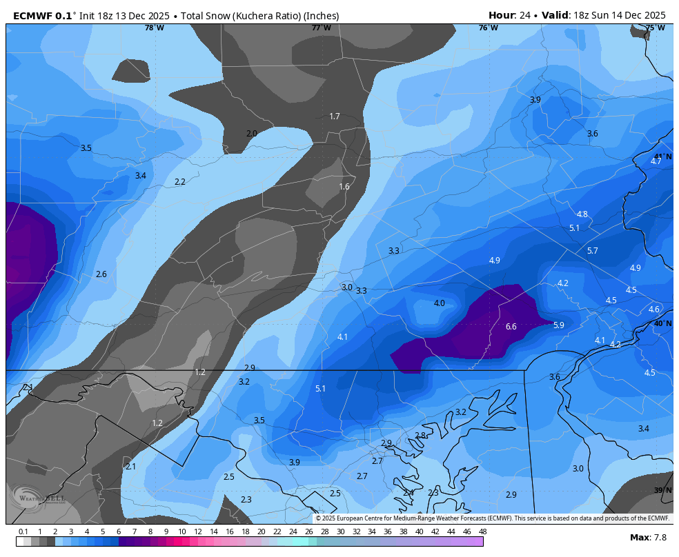
12z National Blend of Models has its best look yet especially back towards the Harrisburg area with almost 3 inches back there now.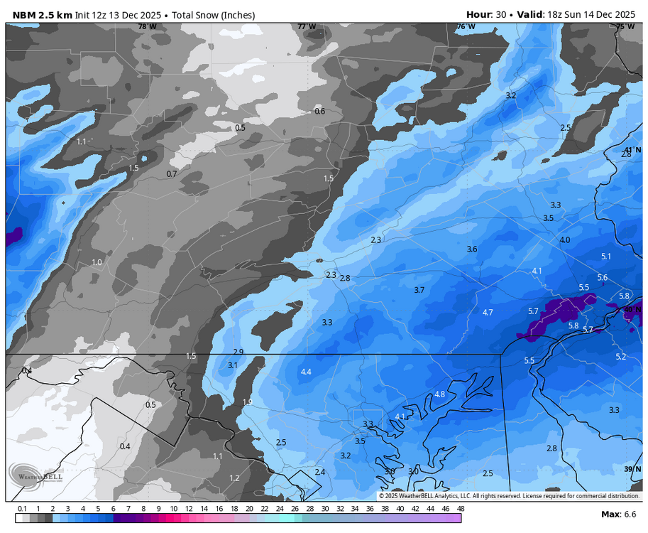
-
Central PA Winter 25/26 Discussion and Obs
Blizzard of 93 replied to MAG5035's topic in Upstate New York/Pennsylvania
You have 10:1 Chris posted Kuchera which will factor in the helpful ratios in this scenario. -
Central PA Winter 25/26 Discussion and Obs
Blizzard of 93 replied to MAG5035's topic in Upstate New York/Pennsylvania
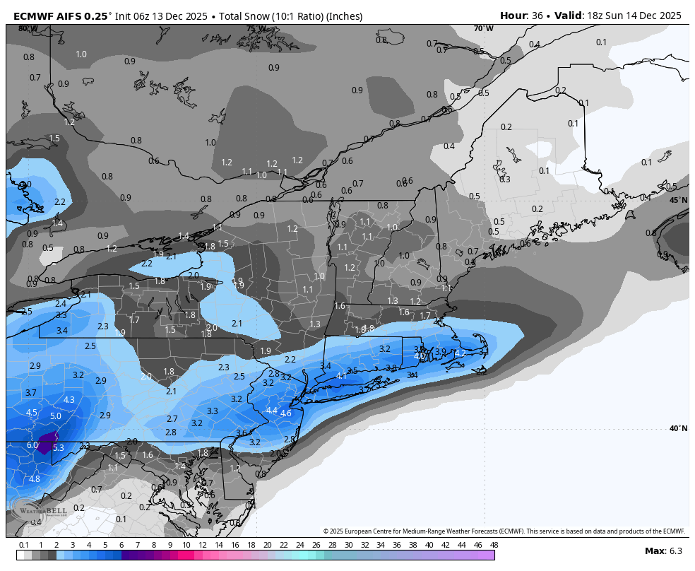
6z RGEM & 6z Euro AI remain consistent. 6z Euro AI improved for the Harrisburg area.
-
Central PA Winter 25/26 Discussion and Obs
Blizzard of 93 replied to MAG5035's topic in Upstate New York/Pennsylvania
Very nice! Let’s goooo! -
Central PA Winter 25/26 Discussion and Obs
Blizzard of 93 replied to MAG5035's topic in Upstate New York/Pennsylvania
The 0z Euro & GFS still are advertising potential chances near Christmas. -
-
Central PA Winter 25/26 Discussion and Obs
Blizzard of 93 replied to MAG5035's topic in Upstate New York/Pennsylvania
Winter Weather Advisory URGENT - WINTER WEATHER MESSAGE National Weather Service State College PA 1114 PM EST Fri Dec 12 2025 PAZ065-066-131700- /O.EXB.KCTP.WW.Y.0025.251214T0000Z-251214T1800Z/ York-Lancaster- Including the cities of Lancaster and York 1114 PM EST Fri Dec 12 2025 ...WINTER WEATHER ADVISORY IN EFFECT FROM 7 PM SATURDAY TO 1 PM EST SUNDAY... * WHAT...Snow expected. Total snow accumulations between 2 and 3 inches. Locally higher spot amounts are possible. * WHERE...Lancaster and York Counties. * WHEN...From 7 PM Saturday to 1 PM EST Sunday. * IMPACTS...Plan on slippery road conditions. The hazardous conditions could impact the Monday morning commute. -
Central PA Winter 25/26 Discussion and Obs
Blizzard of 93 replied to MAG5035's topic in Upstate New York/Pennsylvania
All dreaming aside, we will warm up this week, but the pattern reshuffle will keep Canada cold. The core of the warm up will be in the Midwest & South. The northeast should still be able to occasionally tap into some of the available Canadian cold. With well timed Highs nosing in from eastern Canada, we could still have Winter weather chances once we head into Christmas week.