Blizzard of 93
-
Posts
13,024 -
Joined
-
Last visited
Content Type
Profiles
Blogs
Forums
American Weather
Media Demo
Store
Gallery
Everything posted by Blizzard of 93
-
Central PA Winter 25/26 Discussion and Obs
Blizzard of 93 replied to MAG5035's topic in Upstate New York/Pennsylvania
Looking out to the longer range, the full first week of January looks to be active with chances for Wintry weather. Current modeling shows storm systems actually approaching from the south & west instead of the current northern stream dominated pattern from the last few weeks. I think we may be busy tracking on here just after New Year’s. Here’s an example from the overnight Euro & GFS of the early January potential. -
Central PA Winter 25/26 Discussion and Obs
Blizzard of 93 replied to MAG5035's topic in Upstate New York/Pennsylvania
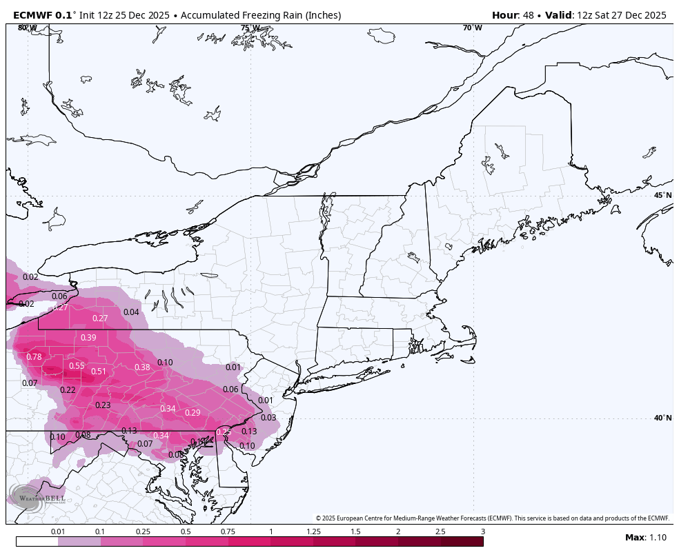
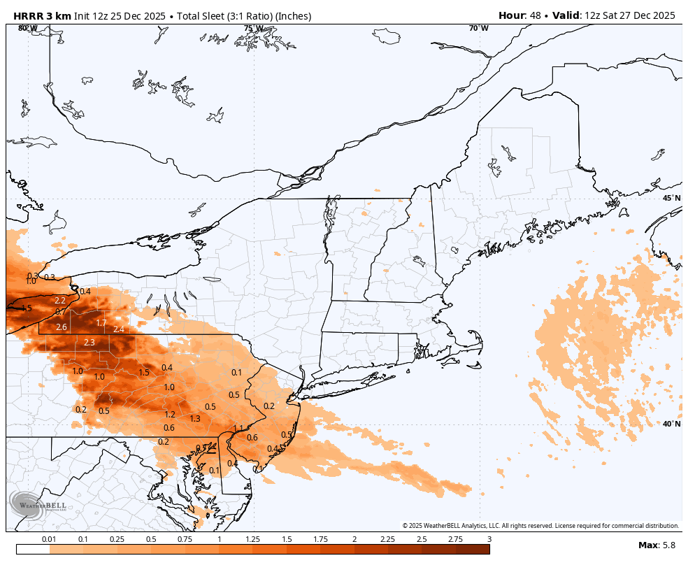
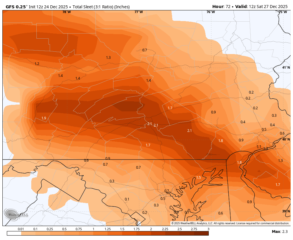
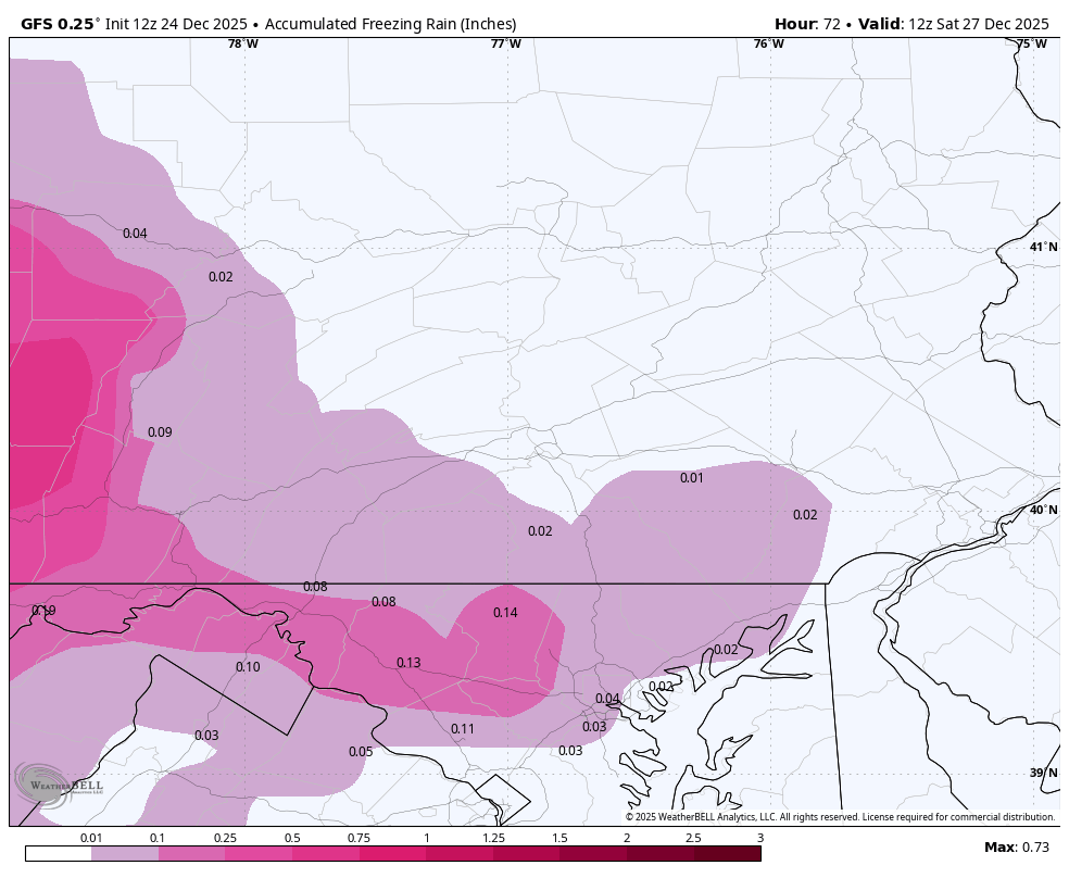
More from CTP An impactful winter system is expected to impact central Pennsylvania on Boxing Day (Friday) with a wintry mix in play for the entire forecast area as a shortwave trough and low pressure associated with this feature currently stationed over the Midwest approach the region. Ahead of this system, departing high pressure has allowed for some clearing with a shallow cold air wedge beginning for form on the eastern periphery of the Appalachians, setting up a cold air damming (CAD) set up ahead of the precipitation. Given this signal, have trended temperatures throughout the entire near-term below NBM guidance given that there will be impact on precipitation types as temperatures generally range in the mid-to-upper 20s across the area as precipitation begins across the region. Recent model soundings continue to outline an elevated warm nose across western Pennsylvania, which continues to outline this area for the highest freezing rain potential with this system in the areas where an Ice Storm Warning remains in effect. The bulk of model guidance continues to outline freezing rain continuing throughout much of the event across the Laurels and portions of northwestern Pennsylvania, with the best timing for significant icing coming between 18Z-00Z (1pm-7pm EST) with some sleet beginning to mix in during this timeframe. Minimal changes to the forecast in this area of the CWA with this forecast cycle, thus the Ice Storm Warning remains in good shape moving forward. Further east, there recent HREF model guidance continues to outline the central third of the forecast area for sleet potential at onset with areas north/east of I-80/US-15 likely experiencing a brief window of snow before transitioning to sleet after 18Z (1pm EST). Sleet/snow accumulations generally range between below an inch for the southwestern two-thirds of the forecast area with recent NBM/HREF model guidance bringing a slight increase in snowfall totals across the eastern periphery of the forecast area, where 1-2" of storm-total snowfall is expected. Winter Weather Advisory remains unchanged this cycle; however, quicker movement of the system could promote the bulk of precipitation tapering off across the forecast area shortly after midnight Friday night. -
Central PA Winter 25/26 Discussion and Obs
Blizzard of 93 replied to MAG5035's topic in Upstate New York/Pennsylvania
CTP is on their game this morning. NEAR TERM /THROUGH TONIGHT/... KEY MESSAGES: - Precipitation enters west-central Pennsylvania slightly after sunrise, with a mix of freezing rain and sleet being the predominant precipitation type at onset. - Wintry mix expands across all of central Pennsylvania during the morning hours, continuing through the evening hours. - Prolonged threat for freezing rain on Friday brings the highest ice accumulation across western Pennsylvania, where an Ice Storm Warning is in effect. - Sleet/snow accumulations across the rest of central Pennsylvania will bring slick conditions for those traveling on Friday, where a Winter Weather Advisory is in effect. -
Central PA Winter 25/26 Discussion and Obs
Blizzard of 93 replied to MAG5035's topic in Upstate New York/Pennsylvania
This forecast is wayyyyyyyyyyy off for CTP area at least! Wow, they are truly delusional & living in fantasy land! -
Central PA Winter 25/26 Discussion and Obs
Blizzard of 93 replied to MAG5035's topic in Upstate New York/Pennsylvania
CTP has no changes & just reissued this in the last hour… Winter Weather Advisory URGENT - WINTER WEATHER MESSAGE National Weather Service State College PA 951 PM EST Thu Dec 25 2025 PAZ006-011-012-018-019-025>028-034>037-041-042-045-046-049>053- 056>059-063>066-261800- /O.CON.KCTP.WW.Y.0027.251226T1700Z-251227T1200Z/ Potter-Cameron-Northern Clinton-Northern Centre-Southern Centre- Blair-Huntingdon-Mifflin-Juniata-Bedford-Fulton-Franklin-Tioga- Northern Lycoming-Sullivan-Southern Clinton-Southern Lycoming- Union-Snyder-Montour-Northumberland-Columbia-Perry-Dauphin- Schuylkill-Lebanon-Cumberland-Adams-York-Lancaster- Including the cities of Williamsport, Mifflintown, Pottsville, Lock Haven, Newport, York, Danville, Lebanon, State College, Altoona, Emporium, Berwick, Coudersport, Philipsburg, Wellsboro, Huntingdon, Chambersburg, Lewisburg, Mansfield, Carlisle, Lancaster, Lewistown, Shamokin, Sunbury, Hershey, Bloomsburg, Gettysburg, Mount Union, Bedford, Trout Run, Laporte, Harrisburg, Renovo, Selinsgrove, and McConnellsburg 951 PM EST Thu Dec 25 2025 ...WINTER WEATHER ADVISORY REMAINS IN EFFECT FROM NOON FRIDAY TO 7 AM EST SATURDAY... * WHAT...Mixed precipitation expected. Total snow and sleet accumulations up to two inches and ice accumulations up to two tenths of an inch. * WHERE...Most of central Pennsylvania. * WHEN...From noon Friday to 7 AM EST Saturday. * IMPACTS...Plan on slippery road conditions. The hazardous conditions will impact the Friday evening commute. * ADDITIONAL DETAILS...Much of the precipitation could fall as sleet. Sleet and freezing rain can both be dangerous, especially on bridges and sidewalks. They can also weigh down tree limbs and power lines. Power outages are possible. -
Central PA Winter 25/26 Discussion and Obs
Blizzard of 93 replied to MAG5035's topic in Upstate New York/Pennsylvania
Lol, with temps in the 20s & at least .3 of precipitation on the way…? Maybe it will be 80 tomorrow & we can jump in a swimming pool too? -
The only probability scale that we should be using is the fact that any models forecasting warmth in week 2 or beyond have been wrong this season. Cold has won out since Thanksgiving this year. We will have our chances to score.
-
Central PA Winter 25/26 Discussion and Obs
Blizzard of 93 replied to MAG5035's topic in Upstate New York/Pennsylvania
I’m expecting a disaster on the roads. Lots of people off of work will be out shopping, using restaurant gift cards & continuing holiday get togethers. Too many people with the “it’s not so bad” attitude could be involved in holiday fender benders. -
12z Euro showed a chance on January 6th. We should have our opportunities.
-
Central PA Winter 25/26 Discussion and Obs
Blizzard of 93 replied to MAG5035's topic in Upstate New York/Pennsylvania
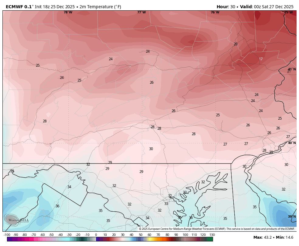
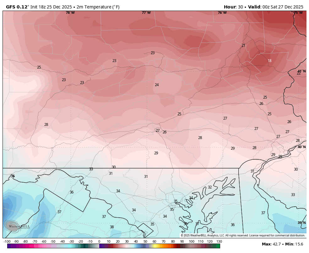
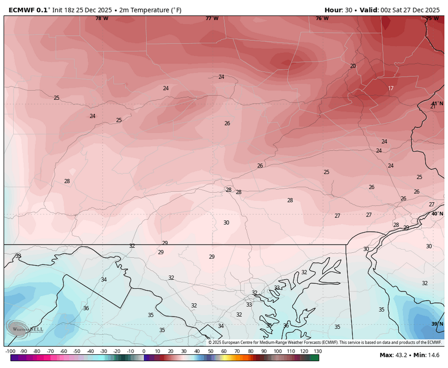
Temps on both Euro & GFS are still in the 20s for most of us tomorrow early evening at 7 pm.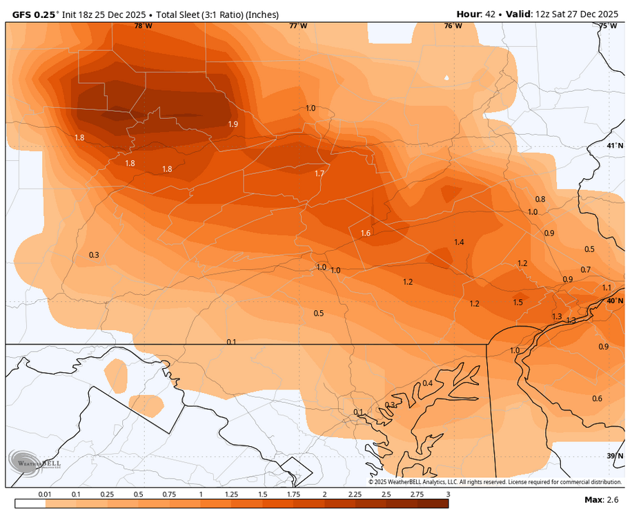


-
Central PA Winter 25/26 Discussion and Obs
Blizzard of 93 replied to MAG5035's topic in Upstate New York/Pennsylvania
Exactly, we are not getting near freezing tomorrow. Conditions won’t improve until Saturday am. 18z Euro says majority is freezing rain. 18z GFS says majority is sleet for us.
-
Central PA Winter 25/26 Discussion and Obs
Blizzard of 93 replied to MAG5035's topic in Upstate New York/Pennsylvania
12z Euro still sees this as primarily a freezing rain threat for most of us. Some have mentioned the Euro struggles to see sleet, so it will come down to the upper level temperatures. Surface temperature at the height of the storm tomorrow evening are in the 20s for most of us, so whatever falls will be a problem on the roads.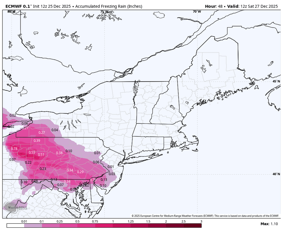
-
Central PA Winter 25/26 Discussion and Obs
Blizzard of 93 replied to MAG5035's topic in Upstate New York/Pennsylvania
12z HRRR gets a good amount of sleet into most of CTP & the decent snow line this run gets into a good portion of Dauphin, Lebanon & Lancaster county.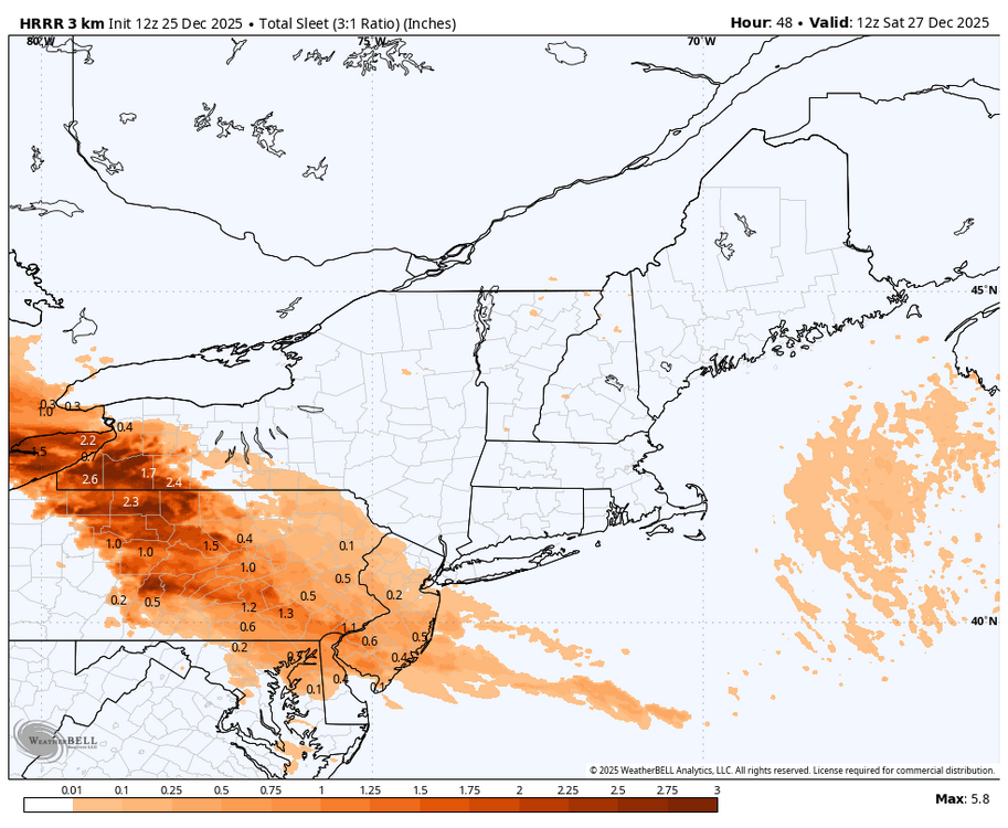
-
Central PA Winter 25/26 Discussion and Obs
Blizzard of 93 replied to MAG5035's topic in Upstate New York/Pennsylvania
Still nice to have this even though it’s a mix mess… Winter Storm Watch URGENT - WINTER WEATHER MESSAGE National Weather Service State College PA 213 AM EST Thu Dec 25 2025 PAZ004>006-011-012-018-019-026>028-035-036-045-049-050-056-057-059- 063>066-252100- /O.CON.KCTP.WS.A.0012.251226T1200Z-251227T1200Z/ Warren-McKean-Potter-Cameron-Northern Clinton-Northern Centre- Southern Centre-Huntingdon-Mifflin-Juniata-Fulton-Franklin- Southern Clinton-Union-Snyder-Perry-Dauphin-Lebanon-Cumberland- Adams-York-Lancaster- Including the cities of Lock Haven, Mifflintown, Emporium, Warren, Chambersburg, Renovo, Selinsgrove, Bradford, Mount Union, Newport, Lewistown, Lebanon, Carlisle, State College, Lancaster, Harrisburg, Philipsburg, Lewisburg, Gettysburg, Huntingdon, Coudersport, Hershey, York, and McConnellsburg 213 AM EST Thu Dec 25 2025 ...WINTER STORM WATCH REMAINS IN EFFECT FROM FRIDAY MORNING THROUGH SATURDAY MORNING... * WHAT...Heavy mixed precipitation possible. Total snow and sleet accumulations up to two inches and ice accumulations up to one quarter of an inch possible. * WHERE...A portion of central Pennsylvania. * WHEN...From Friday morning through Saturday morning. * IMPACTS...Hazardous travel conditions are likely. Plan on slippery road conditions. Power outages and tree damage are possible due to the ice. The hazardous conditions could impact the Friday morning and evening commutes. -
Central PA Winter 25/26 Discussion and Obs
Blizzard of 93 replied to MAG5035's topic in Upstate New York/Pennsylvania
Merry Christmas everyone! -
Remember around Thanksgiving when we thought we were going to lose the first 2 weeks of December & then things would look better towards mid month…? Reality is that we had well below normal temps & most have had a couple of measurable snow events. This upcoming pattern looks variable with chances if of course the timing & track are right.
-
Central PA Winter 25/26 Discussion and Obs
Blizzard of 93 replied to MAG5035's topic in Upstate New York/Pennsylvania
That was a little over a week after many of us got around 10 inches of snow that got wiped out by the storm you are referencing. -
Central PA Winter 25/26 Discussion and Obs
Blizzard of 93 replied to MAG5035's topic in Upstate New York/Pennsylvania
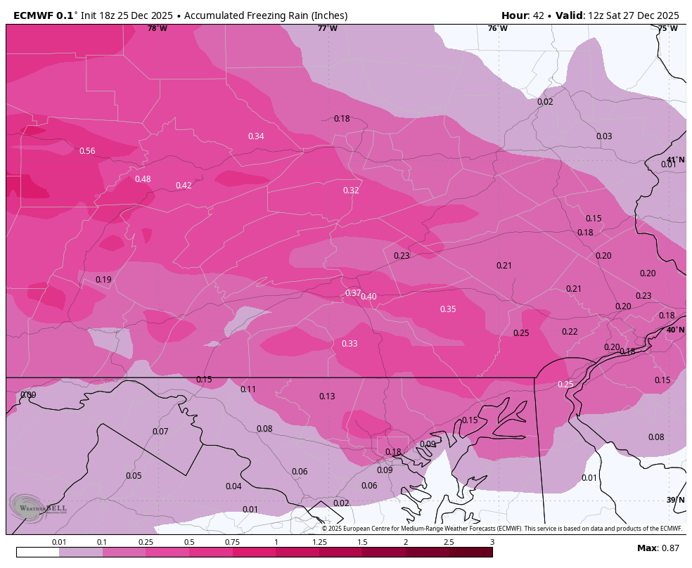
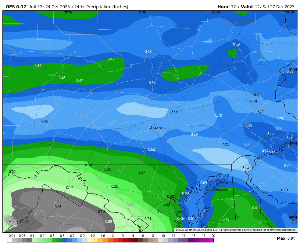
12z GFS is bringing .50 to .75 of precip into the cold dome. Hopefully heavy rates at the start can put down a little snow before the warming aloft kicks in, but it that amount of sleet would be impressive.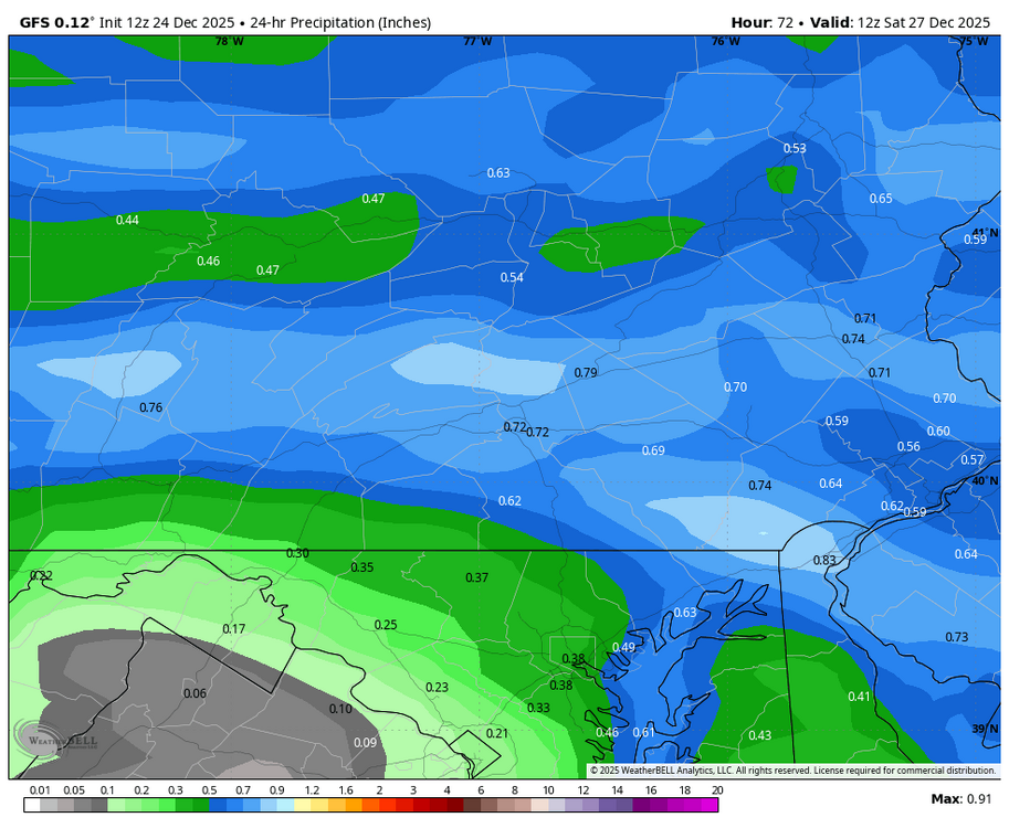
-
Central PA Winter 25/26 Discussion and Obs
Blizzard of 93 replied to MAG5035's topic in Upstate New York/Pennsylvania
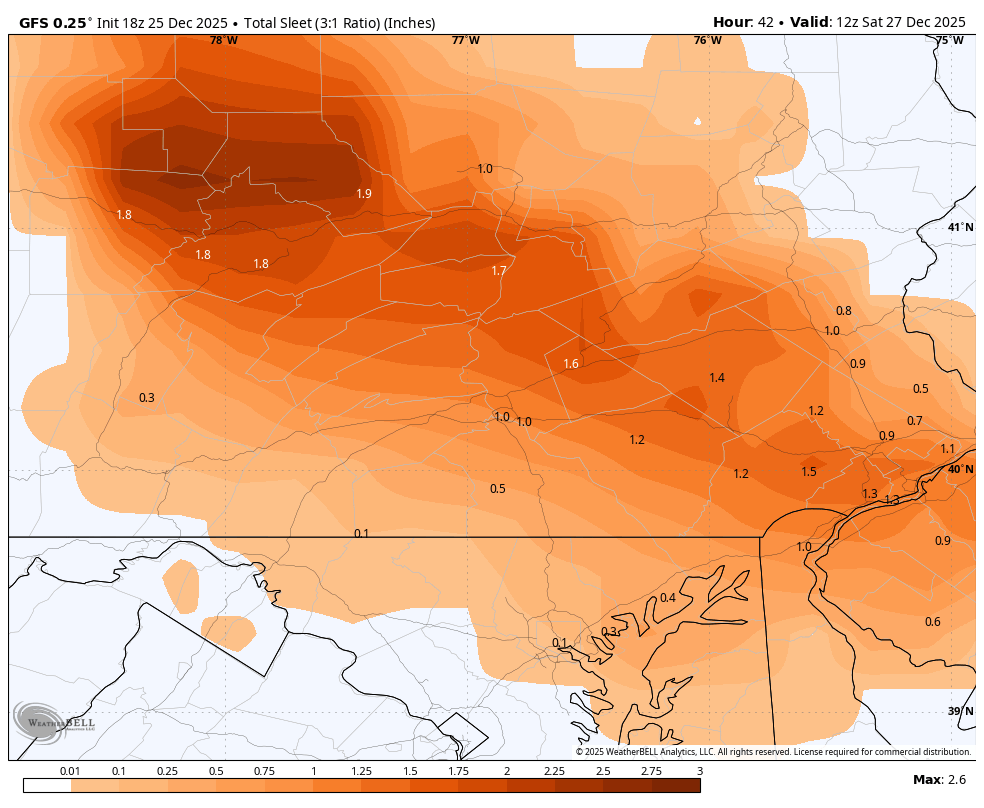
For those of us team heavy sleet, the 12z GFS delivers around 2 inches of sleet in the LSV on Friday with minimal freezing rain this run.
-
Central PA Winter 25/26 Discussion and Obs
Blizzard of 93 replied to MAG5035's topic in Upstate New York/Pennsylvania
Lol, their word salad point & clicks are amusing. -
Central PA Winter 25/26 Discussion and Obs
Blizzard of 93 replied to MAG5035's topic in Upstate New York/Pennsylvania
Agreed, if we must have a slop fest, I don’t mind them as much when we actually get the 1 or two inches of snow before the mix to sleet/freezing rain. The look of snow on the ground plus the building layer of ice makes the scenery much better. This storm looks to change over to mostly sleet in the LSV, so we can hopefully measure & pad stats too. -
Central PA Winter 25/26 Discussion and Obs
Blizzard of 93 replied to MAG5035's topic in Upstate New York/Pennsylvania
CTP recorded .3” of snow yesterday bringing the seasonal total to date to 5.0” ,which is 1.0 above normal season to date. -
Central PA Winter 25/26 Discussion and Obs
Blizzard of 93 replied to MAG5035's topic in Upstate New York/Pennsylvania
CTP’s thoughts on Friday. SHORT TERM /THURSDAY THROUGH FRIDAY NIGHT/... The weather looks largely benign for the rest of Christmas Day with cloudy skies, WNW breeze and max temps +5-10F above the historical average. High pressure ridge drifts over CPA Thursday night bringing some clearing and colder min temps in the 15-25F range. The sfc ridge and cold air wedge channels down the east side of the Appalachians by Friday morning - setting the stage for a classic CAD "overrunning" post-Christmas wintry mix event. Strong warm air advection, isentropic lift, and healthy mid-to- upper level ascent (ahead of sfc low tracking from IA/IL border eastward to western PA btwn 12-24Z Friday) will send anomalous moisture plume into a cold and dry boundary layer (sub-freezing wet bulb temperatures at the surface). This will allow for an icy mix of sleet/freezing rain over the southwest 1/3 of the CWA. The best ice signal >0.25" is over the Laurel Highlands. Farther to the northeast where cold layer is gradually deeper, snow/sleet/zr transition is forecast. A deep cold layer below the elevated warm nose could favor the majority of precip falling as sleet over the interior central ridge and valley region where WPC WWD shows a broad area of 0.50"+ of sleet accumulation. Precip should stay snow the longest over the northeast periphery of the CWA with perhaps up to 4-6" in the eastern portions of Tioga/Sullivan/Columbia/Schuylkill Cos. There remains ongoing fluctuations in the forecast track which could result in additional changes to which areas see the most snow and ice. That being said, we have high confidence in an impactful post-Christmas winter wx event. We issued a winter storm watch for the entire CWA with an emphasis on hazardous travel impacts -
Central PA Winter 25/26 Discussion and Obs
Blizzard of 93 replied to MAG5035's topic in Upstate New York/Pennsylvania
0z GFS shows heavy sleet for most of us on Friday. Warning level snow for northeast PA this run.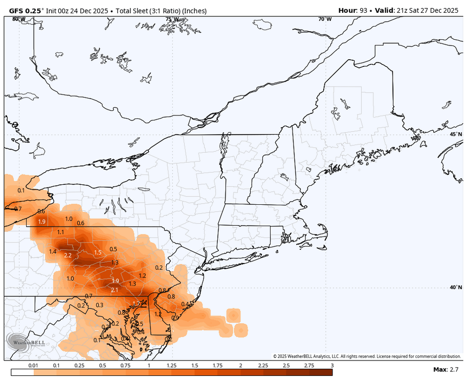

-
Central PA Winter 25/26 Discussion and Obs
Blizzard of 93 replied to MAG5035's topic in Upstate New York/Pennsylvania
Tomorrow should be relatively nice with sun & temps in the low 40s. Hopefully that helps a bit.