Blizzard of 93
-
Posts
13,024 -
Joined
-
Last visited
Content Type
Profiles
Blogs
Forums
American Weather
Media Demo
Store
Gallery
Everything posted by Blizzard of 93
-
Central PA Winter 25/26 Discussion and Obs
Blizzard of 93 replied to MAG5035's topic in Upstate New York/Pennsylvania
6z GFS is the Best run yet with more room for upside with a more tucked track. Here’s the 6z GFS snow by the 16th. -
Exactly! First things first… We need to determine the 15th/16th before we worry about what’s next. Best run yet with more room for upside with a more tucked track. Here’s the 6z GFS snow by the 16th.
-
Lol, I think most of us would sign up now for that… Only 10 days to go. Hopefully we reel in the 15th/16th too.
-
Central PA Winter 25/26 Discussion and Obs
Blizzard of 93 replied to MAG5035's topic in Upstate New York/Pennsylvania
0z Euro for the 18th. -
0z Euro for the 18th.
-
0z AI Euro likes the 18th.
-
Central PA Winter 25/26 Discussion and Obs
Blizzard of 93 replied to MAG5035's topic in Upstate New York/Pennsylvania
So much potential on the 0z GFS… -
So much potential in this time frame…
-
We usually need a couple of chances to score… Maybe the storm after the storm will be the one?
-
Central PA Winter 25/26 Discussion and Obs
Blizzard of 93 replied to MAG5035's topic in Upstate New York/Pennsylvania
Lots of chances on the 12z Euro as you mentioned. This run didn’t fully develop any healthy systems, but lots of nickels & dimes verbatim. That being said, they added up. The run still produced 4 to 6 inches of snow for the Susquehanna Valley by day 15. Lots of time, but maybe a few opportunities in the next couple of weeks. -
It brings a decent stripe of precip on the 18th but the snow is from I-81 & west.
-
Central PA Winter 25/26 Discussion and Obs
Blizzard of 93 replied to MAG5035's topic in Upstate New York/Pennsylvania
Global ensembles overnight continued to ramp up snow amounts for week 2 through day 16. We should at least have chances for Winter weather tracking starting next week & beyond. -
Central PA Winter 25/26 Discussion and Obs
Blizzard of 93 replied to MAG5035's topic in Upstate New York/Pennsylvania
The best part about 0z so far for the 15th is that both the GFS & Canadian have an organized low that brings snow to the region. The last few days have shown a random run here or there that have looked interesting, but tonight it’s good to see both models with a decent system that snows on us or very close by. -
The best part about 0z so far for the 15th is that both the GFS & Canadian have an organized low that brings snow to the region. The last few days have shown a random run here or there that have looked interesting, but tonight it’s good to see both models with a decent system that snows on us.
-
@mitchnick @Ji The ensembles are starting to beef up their snow amounts today for the last 10 days of their runs. 12z Canadian ensemble got it started. 18z GEFS & 18z AI EPS really ramped up. Hopefully this continues to build up as most of the potential is from day 9 onward.
-
Central PA Winter 25/26 Discussion and Obs
Blizzard of 93 replied to MAG5035's topic in Upstate New York/Pennsylvania
Happy birthday @sauss06 ! -
Central PA Winter 25/26 Discussion and Obs
Blizzard of 93 replied to MAG5035's topic in Upstate New York/Pennsylvania
The 6z GFS was a beautiful run showing coastal potential on the 16th. -
Central PA Winter 25/26 Discussion and Obs
Blizzard of 93 replied to MAG5035's topic in Upstate New York/Pennsylvania
That’s my close #2 best week in my opinion. The historic first storm in 96 places it just above 2010 for me. Either way, they are a clear #1 & #2 for best snow weeks in the last 30 years or more. -
Central PA Winter 25/26 Discussion and Obs
Blizzard of 93 replied to MAG5035's topic in Upstate New York/Pennsylvania
The overnight Op runs are coming around to the idea of a moisture laden storm that rides up the coast. The 0z Euro liked the 18th, but missed just to our south this run. Plenty of time & potential in this period. -
Central PA Winter 25/26 Discussion and Obs
Blizzard of 93 replied to MAG5035's topic in Upstate New York/Pennsylvania
Great memories from the Blizzard of 96 back when I was a freshman in college. That week of weather with the Blizzard dropping 2 feet near Harrisburg, the mid week over performing Clipper that brought a few inches, to the end of week significant coast that brought another foot to the Harrisburg area still stands as the greatest week of weather in my lifetime. -
Central PA Winter 25/26 Discussion and Obs
Blizzard of 93 replied to MAG5035's topic in Upstate New York/Pennsylvania
0z GFS is looking a lot more interesting for the chance on the 15th. Definitely room for possible improvement at the surface with this look at H5. -
Central PA Winter 25/26 Discussion and Obs
Blizzard of 93 replied to MAG5035's topic in Upstate New York/Pennsylvania
18z GFS shows a couple of opportunities between the 15th & 19th. The first chance is light this run, but could have been more if the pieces phased better. The second chance misses south this run, but again the potential is there. -
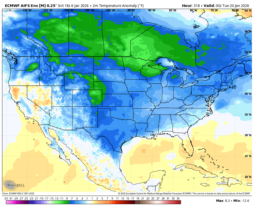
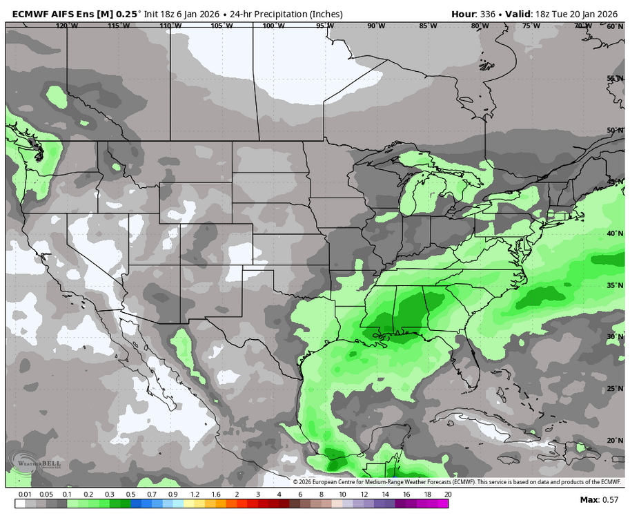
18z AI EPS also likes the 20th period.

-
That run was close to delivering at least 3 events by day 16. I think it’s just a matter of time until we are keying in on a specific trackable storm.
-
Central PA Winter 25/26 Discussion and Obs
Blizzard of 93 replied to MAG5035's topic in Upstate New York/Pennsylvania
0z GFS has another potential juicy looking system approaching this run on day 16.