Blizzard of 93
-
Posts
13,024 -
Joined
-
Last visited
Content Type
Profiles
Blogs
Forums
American Weather
Media Demo
Store
Gallery
Everything posted by Blizzard of 93
-
0z GFS has another potential juicy looking system approaching this run on day 16.
-
Central PA Winter 25/26 Discussion and Obs
Blizzard of 93 replied to MAG5035's topic in Upstate New York/Pennsylvania
0z GFS for the 15th has a low approaching from the south that rides up & off of the coast. It was closer to something more this run, but most of us at this point would take it as depicted this run. -
Definitely close to something more this run.
-
Of course…but just showing what the model shows at this time. It should just be used to get a general idea. Hopefully it’s on the right track…
-
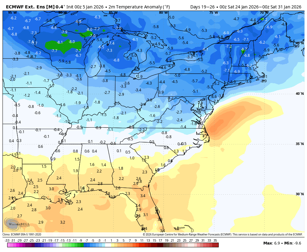
The Euro Weeklies today look even better in terms of temperatures & precip for the 7 day period ending January 31. Bottom line if the ensembles & Weeklies have the right general idea, we should have chances for Winter storms for mid month through the end of the month.
-
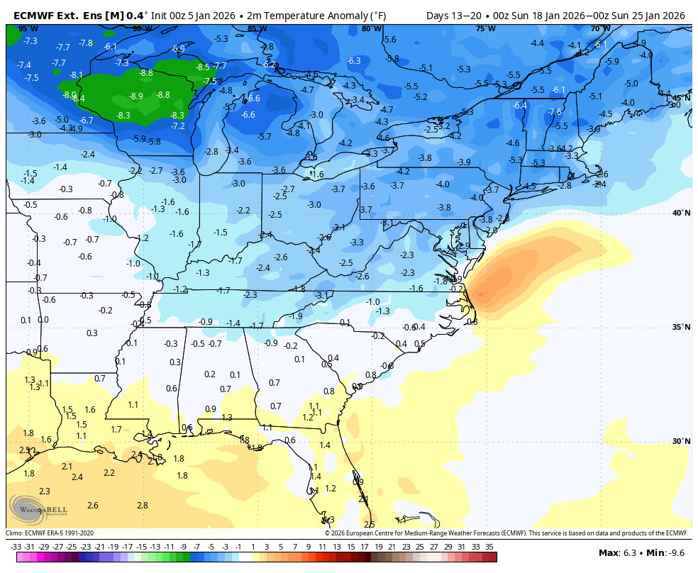
Today’s Euro Weeklies agree with liking this same period for a better looking amount of precip with below normal temperatures for the 7 day window ending the 25th.

-
As you mentioned, ensemble guidance again today showed a workable pattern for week 2 that should offer chances for Winter storms. Good agreement on the ensembles as well.
-
Central PA Winter 25/26 Discussion and Obs
Blizzard of 93 replied to MAG5035's topic in Upstate New York/Pennsylvania
As you mentioned, ensemble guidance again today showed a workable pattern for week 2 that should offer chances for Winter storms. Good agreement on the ensembles as well. -
18z AI ensembles also agree with the good look in week 2.
-
Central PA Winter 25/26 Discussion and Obs
Blizzard of 93 replied to MAG5035's topic in Upstate New York/Pennsylvania
Enjoy the 4 day warm up… -
Exactly, the window opens early NEXT week…
-
Central PA Winter 25/26 Discussion and Obs
Blizzard of 93 replied to MAG5035's topic in Upstate New York/Pennsylvania
12z EPS day 10 to 15 still looks workable and day 15 ends on a good note as well. It’s just a matter of time until something trackable shows on the Op run again. -
12z EPS day 10 to 15 still looks workable and day 15 ends on a good note as well. It’s just a matter of time until something trackable shows on the Op run again.
-
Central PA Winter 25/26 Discussion and Obs
Blizzard of 93 replied to MAG5035's topic in Upstate New York/Pennsylvania
The Ops are changing run to run. Ensembles -see my post above & yesterday & the day before…- as they have shown for several days, are showing a workable pattern starting early next week. -
Central PA Winter 25/26 Discussion and Obs
Blizzard of 93 replied to MAG5035's topic in Upstate New York/Pennsylvania
The better workable pattern is moving up closer in time. Here are the day 8 to 13 looks for the 5 day period on the 0z EPS, 6z AI EPS & 6z GEFS. -
What exactly am I supposed to be upset about this morning…? The better workable pattern is moving up closer in time. Here are the day 8 to 13 looks for the 5 day period on the 0z EPS, 6z AI EPS & 6z GEFS.
-
Central PA Winter 25/26 Discussion and Obs
Blizzard of 93 replied to MAG5035's topic in Upstate New York/Pennsylvania
12z Euro has a good looking Winter storm chance on the 14th for us this run with a juicy system approaching from the south that passes underneath of us. -
Central PA Winter 25/26 Discussion and Obs
Blizzard of 93 replied to MAG5035's topic in Upstate New York/Pennsylvania
CTP had this great post. I certainly wouldn’t mind a 13-14 repeat here, except this time add on the 3 March events that just missed us to our south in MD. -
Central PA Winter 25/26 Discussion and Obs
Blizzard of 93 replied to MAG5035's topic in Upstate New York/Pennsylvania
Key word is a bit… This warm up is brief. Winter returns by the 12th -
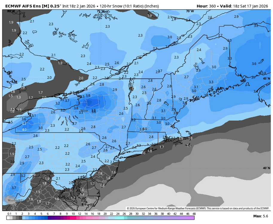
Here’s the day 10 to 15 AI Euro Ensemble look & snow for the period.
-
Central PA Winter 25/26 Discussion and Obs
Blizzard of 93 replied to MAG5035's topic in Upstate New York/Pennsylvania
The 18z GFS is showing snow this run on the 11th. -
Lol, there is so much griping on here that the cliff jumpers & Debs missed the 18z GFS showing snow this run on the 11th.
-
Central PA Winter 25/26 Discussion and Obs
Blizzard of 93 replied to MAG5035's topic in Upstate New York/Pennsylvania
The 12z AI Euro & AI GEFS also show a very workable look in the day 10 to 15 period. -
12z Synopsis EPS, EPS AI, CMC ensemble, & GEFS AI ensemble all have a very workable & generally similar look in the day 10 to 15 period. Only the GEFS looked different…but @CAPE said that it looked workable as well.
-
The 12z AI Euro & AI GEFS also show a very workable look in the day 10 to 15 period.