Blizzard of 93
-
Posts
12,832 -
Joined
-
Last visited
Content Type
Profiles
Blogs
Forums
American Weather
Media Demo
Store
Gallery
Everything posted by Blizzard of 93
-
Central PA Winter 25/26 Discussion and Obs
Blizzard of 93 replied to MAG5035's topic in Upstate New York/Pennsylvania
8 in Marysville for the low & currently. -
Central PA Winter 25/26 Discussion and Obs
Blizzard of 93 replied to MAG5035's topic in Upstate New York/Pennsylvania
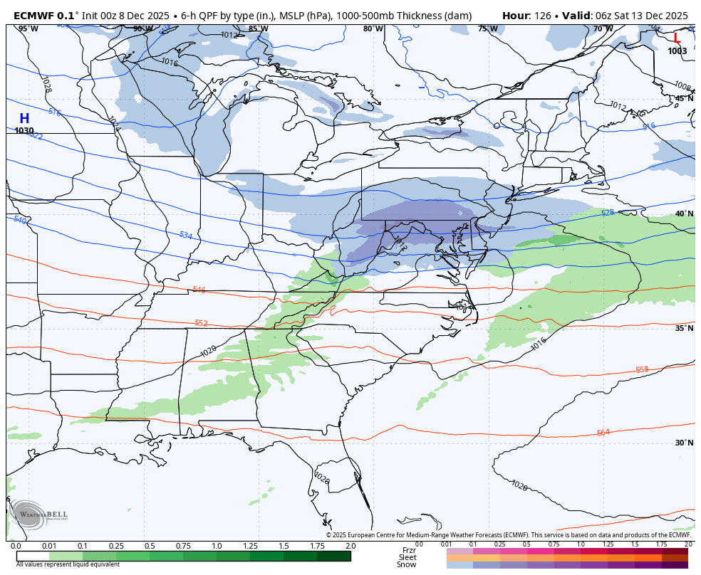
In the shorter term, the 0z GFS still likes the Saturday night chance for an Advisory type of event. -
Central PA Winter 25/26 Discussion and Obs
Blizzard of 93 replied to MAG5035's topic in Upstate New York/Pennsylvania
0z Canadian shows a chance on the 18th. -
0z Canadian shows a chance on the 18th.
-
Central PA Winter 25/26 Discussion and Obs
Blizzard of 93 replied to MAG5035's topic in Upstate New York/Pennsylvania
18z GFS delivered the chance of a CTP special on Saturday night. -
Central PA Winter 25/26 Discussion and Obs
Blizzard of 93 replied to MAG5035's topic in Upstate New York/Pennsylvania
Let’s go!!!! The Winter thread is here! -
Central PA Fall Discussions and Obs
Blizzard of 93 replied to ChescoWx's topic in Upstate New York/Pennsylvania
0z Euro shows a snow chance on Friday night.
-
0z Euro shows a snow chance on Friday night.
-
Central PA Fall Discussions and Obs
Blizzard of 93 replied to ChescoWx's topic in Upstate New York/Pennsylvania
I hope that you had a great day at Elizabeth Farms! We took our 2 daughters there for around the last 8 years. They have a nice set up there to see Santa & get a good photo that often became our Christmas card. We would then take a ride on their horse drawn wagons that take you out to the tree cutting area. We just enjoyed the ride, even though we’ve always had an artificial tree, lol. Then we’d get some cocoa in their gift shop while we warmed up. Our kids always picked out a new ornament for our tree each year. Enjoy it my friend, because time flies! My daughters are now 12 & 14 and this is the first year that we did not go to Elizabeth Farms because they both now have out grown going to see Santa! -
Last year the Euro seasonal run in December had above normal for January and last January ended up well below normal.
-
Central PA Fall Discussions and Obs
Blizzard of 93 replied to ChescoWx's topic in Upstate New York/Pennsylvania
0z GFS show 2 chances of snow. The first chance is Friday & then another chance early next week. -
There’s a decent signal on the 12z EPS for a chance of another Advisory type of event in the Friday/Saturday period.
-
Central PA Fall Discussions and Obs
Blizzard of 93 replied to ChescoWx's topic in Upstate New York/Pennsylvania
There’s a decent signal on the 12z EPS for a chance of another Advisory type of event in the Friday/Saturday period.
-
Central PA Fall Discussions and Obs
Blizzard of 93 replied to ChescoWx's topic in Upstate New York/Pennsylvania
Good post from @Bob Chill Upper air pattern is pretty potent with the neg nao breaking down but no sign of a big storm trigger yet. Just looking at the indices makes you think an Archambault type event is I the cards but the northern stream is so busy that it's running interference on itself lol. Something compact but potent n the NS could pop imho. Blocking is quite strong over the next 5 days then things unwind for a bit. Interesting and complex period on tap. Not really a setup that "locks into" anything so it would be a mistake to marry anything in the mid/long ranges -
Central PA Fall Discussions and Obs
Blizzard of 93 replied to ChescoWx's topic in Upstate New York/Pennsylvania
12z Euro is trying for Friday am as well -
Central PA Fall Discussions and Obs
Blizzard of 93 replied to ChescoWx's topic in Upstate New York/Pennsylvania
12z GFS & Canadian just got a lot more interesting for this Friday. -
Central PA Fall Discussions and Obs
Blizzard of 93 replied to ChescoWx's topic in Upstate New York/Pennsylvania
Lol, the Wednesday Clipper is passing well to our north & we’ll be lucky to see a sprinkle from it. The pattern later this week should give us a couple of chances of light snow. -
Central PA Fall Discussions and Obs
Blizzard of 93 replied to ChescoWx's topic in Upstate New York/Pennsylvania
Indeed, now we just need some snow to come along . -
Central PA Fall Discussions and Obs
Blizzard of 93 replied to ChescoWx's topic in Upstate New York/Pennsylvania
18z GFS trying to get something going next Thursday. -
Central PA Fall Discussions and Obs
Blizzard of 93 replied to ChescoWx's topic in Upstate New York/Pennsylvania
0z Euro is trying to get us a chance next Friday night. -
Central PA Fall Discussions and Obs
Blizzard of 93 replied to ChescoWx's topic in Upstate New York/Pennsylvania
Low of 17 in Marysville -
Central PA Fall Discussions and Obs
Blizzard of 93 replied to ChescoWx's topic in Upstate New York/Pennsylvania
@Itstrainingtime Great call on the MDT low of 21 ! The cloud cover held up their temperature. -
Central PA Fall Discussions and Obs
Blizzard of 93 replied to ChescoWx's topic in Upstate New York/Pennsylvania
Good post about the MJO from @GaWx in the ENSO thread today. “Just like yesterday, the GEFS and EPS disagree on how long the MJO will stay in phase 8: GEFS: only 6 days though it returns for rd 2 on 12/18: But the EPS, which recently has been much steadier and has been verifying better than GEFS since phase 7, once again is going with a very long phase 8 (16+ days, longest in 50 years): you can’t place an MJO better than this in Dec for E US cold lovers (and it looks to be cold the next 10 days per models though one must remember that there are always other factors to consider due to the complexity of the atmosphere):” -
Central PA Fall Discussions and Obs
Blizzard of 93 replied to ChescoWx's topic in Upstate New York/Pennsylvania
Good point, the 7 pm MDT observation still had wind at 13 mph. -
Central PA Fall Discussions and Obs
Blizzard of 93 replied to ChescoWx's topic in Upstate New York/Pennsylvania
CTP has the forecast low at 14 tonight for MDT. The remaining snow cover could help the temps to bottom out. Current dew point is 13 at MDT.