Blizzard of 93
-
Posts
13,024 -
Joined
-
Last visited
Content Type
Profiles
Blogs
Forums
American Weather
Media Demo
Store
Gallery
Everything posted by Blizzard of 93
-
Central PA Winter 25/26 Discussion and Obs
Blizzard of 93 replied to MAG5035's topic in Upstate New York/Pennsylvania
As of 12:30 in Marysville I had 7.5 inches of snow. Sleet unfortunately has mixed in. I cleared my unofficial outdoor snow table, so let’s see what I get the rest of the day with the mixed precip. -
Central PA Winter 25/26 Discussion and Obs
Blizzard of 93 replied to MAG5035's topic in Upstate New York/Pennsylvania
Lol, no it wasn’t me, but we saw the Marysville number & the family applauded. -
Central PA Winter 25/26 Discussion and Obs
Blizzard of 93 replied to MAG5035's topic in Upstate New York/Pennsylvania
MDT is already at .92 precip as of noon with all snow recorded thus far. Mix is imminent, so a couple of inches of sleet are not out of the question with observations to our south. I think @canderson & both went with a little over 12 at MDT. I think we are both still alive in the contest, lol! The guesses above 12 are likely out of it. -
Central PA Winter 25/26 Discussion and Obs
Blizzard of 93 replied to MAG5035's topic in Upstate New York/Pennsylvania
When they mix or change, accumulating sleet will still count. Long way to go -
Central PA Winter 25/26 Discussion and Obs
Blizzard of 93 replied to MAG5035's topic in Upstate New York/Pennsylvania
It’s not over… MDT still is reporting Heavy snow with .25 mile visibility at 11:56 am. -
Central PA Winter 25/26 Discussion and Obs
Blizzard of 93 replied to MAG5035's topic in Upstate New York/Pennsylvania
What do you those radar trends could mean for the Harrisburg area this afternoon? -
Central PA Winter 25/26 Discussion and Obs
Blizzard of 93 replied to MAG5035's topic in Upstate New York/Pennsylvania
MDT has reported Heavy since with every 10 minute Ob with .25 mile visibility or less since 8.15 am. Over 1 inch per hour rates! -
Central PA Winter 25/26 Discussion and Obs
Blizzard of 93 replied to MAG5035's topic in Upstate New York/Pennsylvania
Heavy snow in Marysville 10 degrees -
Central PA Winter 25/26 Discussion and Obs
Blizzard of 93 replied to MAG5035's topic in Upstate New York/Pennsylvania
What are your thoughts on the coastal getting going now? Could it help to delay the mixing later on? -
Central PA Winter 25/26 Discussion and Obs
Blizzard of 93 replied to MAG5035's topic in Upstate New York/Pennsylvania
-
Central PA Winter 25/26 Discussion and Obs
Blizzard of 93 replied to MAG5035's topic in Upstate New York/Pennsylvania
Good to see much of the DC area still holding on to snow still around 8 am. -
Central PA Winter 25/26 Discussion and Obs
Blizzard of 93 replied to MAG5035's topic in Upstate New York/Pennsylvania
Just shy of 4 inches so far in Marysville. Flake size is increasing. -
Central PA Winter 25/26 Discussion and Obs
Blizzard of 93 replied to MAG5035's topic in Upstate New York/Pennsylvania
Yes, it is likely overdone, but it is never a bad thing to have the Euro on your side. It gives a range of outcomes. The general rule is if a model is on its own, it’s likely wrong, so that is my thinking with the NAM. Every other short range & global model says we get more. The reality will likely be somewhere in between. -
Central PA Winter 25/26 Discussion and Obs
Blizzard of 93 replied to MAG5035's topic in Upstate New York/Pennsylvania
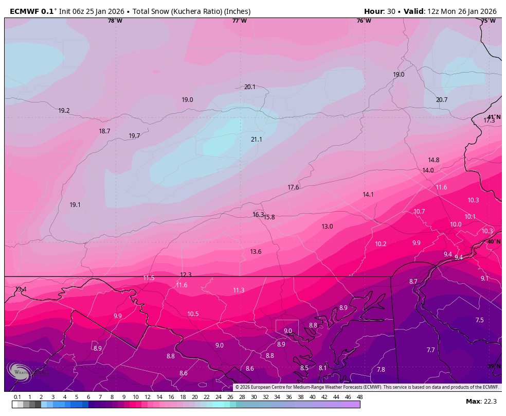
One last look at the Euro at 6z just before game time started overnight. It still crushes the LSV with 13 to 16 and actually improved slightly for York & Lanco over its last run. 6z Euro regional & local view.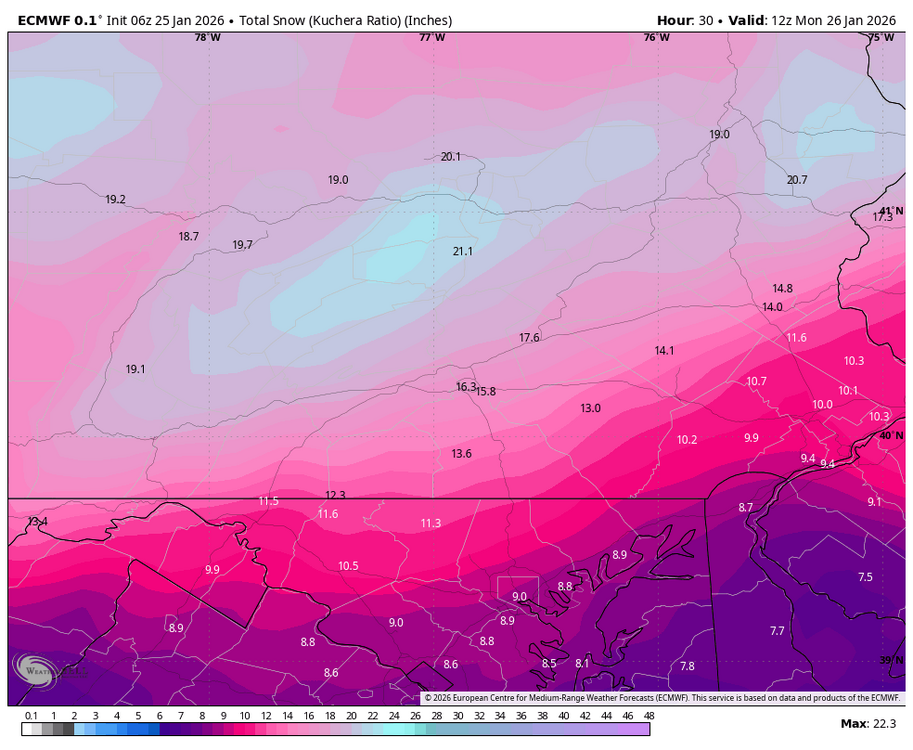
-
Central PA Winter 25/26 Discussion and Obs
Blizzard of 93 replied to MAG5035's topic in Upstate New York/Pennsylvania
SPC -
Central PA Winter 25/26 Discussion and Obs
Blizzard of 93 replied to MAG5035's topic in Upstate New York/Pennsylvania
6z Short term Canadians still good.
-
Central PA Winter 25/26 Discussion and Obs
Blizzard of 93 replied to MAG5035's topic in Upstate New York/Pennsylvania
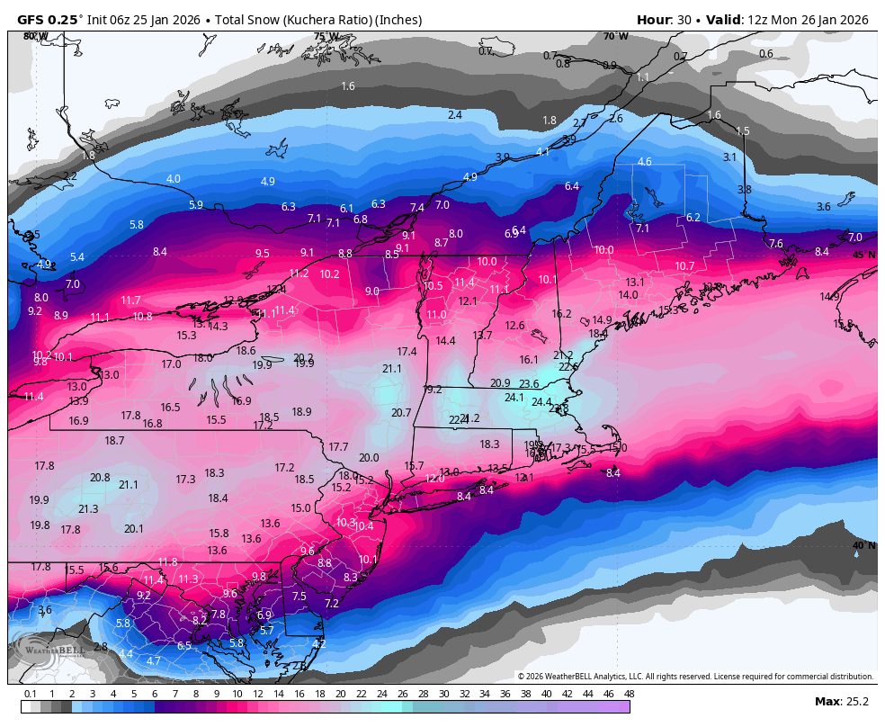
6z GFS still brings 12 to 16 to the LSV today.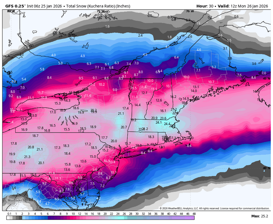
-
Central PA Winter 25/26 Discussion and Obs
Blizzard of 93 replied to MAG5035's topic in Upstate New York/Pennsylvania
Snow in Marysville at 5:15 am All surfaces covered. Eyeballing around 2 inches at this time. -
Central PA Winter 25/26 Discussion and Obs
Blizzard of 93 replied to MAG5035's topic in Upstate New York/Pennsylvania
0z Euro-CTP close up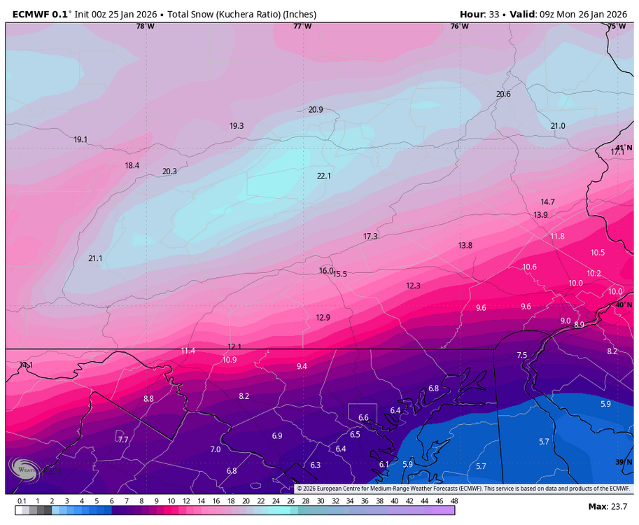
-
Central PA Winter 25/26 Discussion and Obs
Blizzard of 93 replied to MAG5035's topic in Upstate New York/Pennsylvania
0z Euro still is delivering 12 to 16 to the LSV reporting stations. -
Central PA Winter 25/26 Discussion and Obs
Blizzard of 93 replied to MAG5035's topic in Upstate New York/Pennsylvania
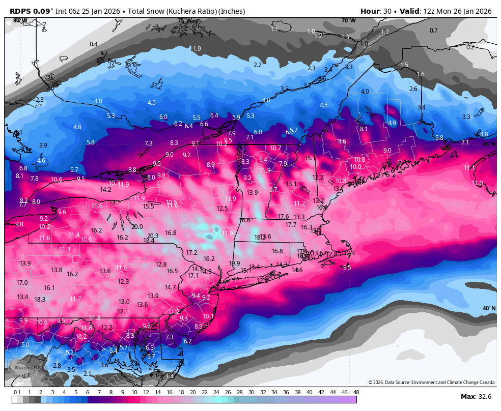
0z High res Canadian HRDPS still looks good. -
Central PA Winter 25/26 Discussion and Obs
Blizzard of 93 replied to MAG5035's topic in Upstate New York/Pennsylvania
0z RGEM still looking good for the LSV -
Central PA Winter 25/26 Discussion and Obs
Blizzard of 93 replied to MAG5035's topic in Upstate New York/Pennsylvania
0z GFS steady for most.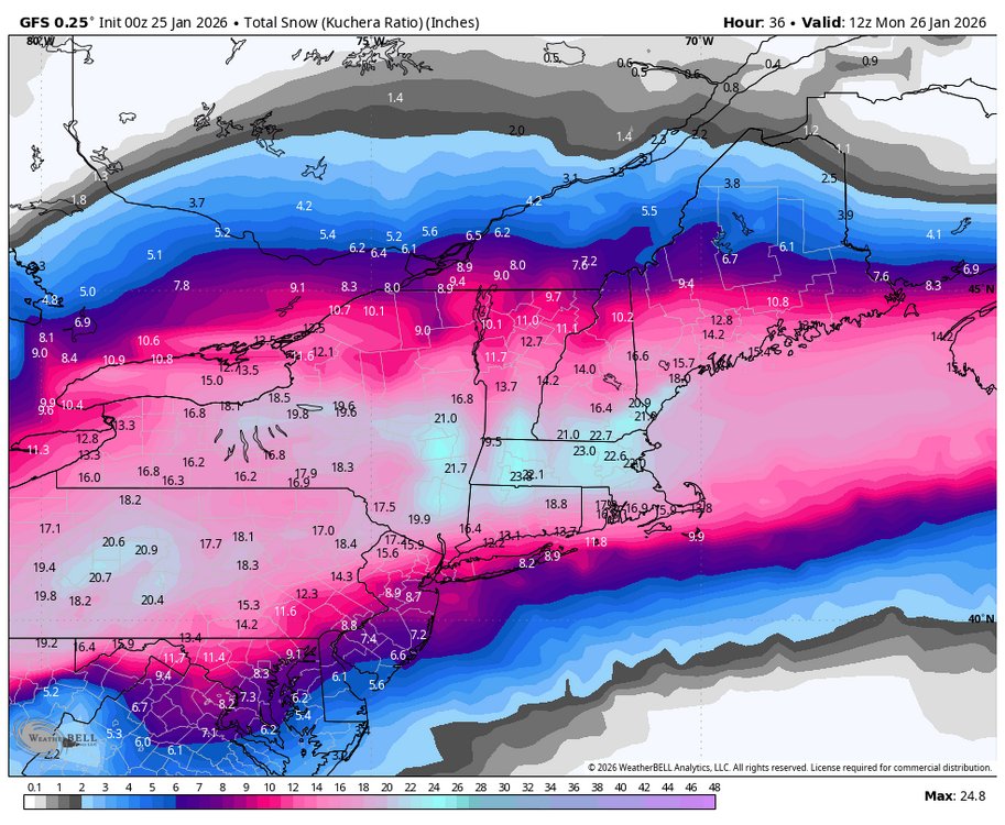
-
Central PA Winter 25/26 Discussion and Obs
Blizzard of 93 replied to MAG5035's topic in Upstate New York/Pennsylvania
18z RGEM looks great for all of us. -
Central PA Winter 25/26 Discussion and Obs
Blizzard of 93 replied to MAG5035's topic in Upstate New York/Pennsylvania
@psuhoffman just made a great post about the model situation for this storm. “So I’ve never seen this drastic of a split between the globals and American run CAMs at this range. What’s odd about this and gives me no past reference to draw on is typically when we see this kind of thing the euro and rgem/HRDPS kind of bridge the gap as those 3 are decent at seeing mid level warming. But they are all in the camp with the other globals (UK/Icon/gfs). The impact is most drastic actually for Maryland. Around DC and south we’re talking maybe the difference between 4-5” and 6-8”. But for places NW of 95 in extreme NW VA up through central MD we’re talking the difference between 5-6” and 10-12”! The divergence seems simple. The globals along with the Canadian high res models have an intense WAA band over the area from 12z-18z that the American CAMs do not. That’s why they are warmer. Less dynamic cooling to fight off the WAA at mid levels. Also less precip. That combo means 6” instead of 12” for places like Winchester-Frederick-westminster. What this comes down to imo is which camp is correct about the precip representation from 12-18z. Unfortunately I don’t have any great insight. Usually here is when I’d be saying “in this or that situation this is what happened” but I can’t remember a single case like this to draw upon. I guess I’m gonna ride with the euro camp. It would be hard to take the NAM and a bunch of experimental stuff over the highest verification tools we have. But on the other hand those CAMs were designed for this. When they score the euro a 30 mile shift in 800 mb temps and a meso scale precip band aren’t really going to impact those scores at all! Yes I just contradicted myself. If I had to make a forecast maybe I’d hedge and go in between even though that’s probably not the most likely outcome, one of these camps is going to win”