Blizzard of 93
-
Posts
13,024 -
Joined
-
Last visited
Content Type
Profiles
Blogs
Forums
American Weather
Media Demo
Store
Gallery
Everything posted by Blizzard of 93
-
Central PA Winter 25/26 Discussion and Obs
Blizzard of 93 replied to MAG5035's topic in Upstate New York/Pennsylvania
This is MDT’s first season officially over 20 inches since 2021. We are now only 10 inches below climo for the season with 2 months still to go to score. -
Central PA Winter 25/26 Discussion and Obs
Blizzard of 93 replied to MAG5035's topic in Upstate New York/Pennsylvania
Side note, when CTP revised it down to 12.5 for the event, they didn’t revise the month & year to date snow properly. Today with the 5 pm summary, the month to date & seasonal snow to date are now all correct. -
Central PA Winter 25/26 Discussion and Obs
Blizzard of 93 replied to MAG5035's topic in Upstate New York/Pennsylvania
We will need a ruling from @GrandmasterB -
Central PA Winter 25/26 Discussion and Obs
Blizzard of 93 replied to MAG5035's topic in Upstate New York/Pennsylvania
-
Central PA Winter 25/26 Discussion and Obs
Blizzard of 93 replied to MAG5035's topic in Upstate New York/Pennsylvania
Not so fast my friends…. Check again… they revised it down to a more realistic 12.5 last night at MDT… I picked 12.3…so I think that crown belongs to me! -
Central PA Winter 25/26 Discussion and Obs
Blizzard of 93 replied to MAG5035's topic in Upstate New York/Pennsylvania
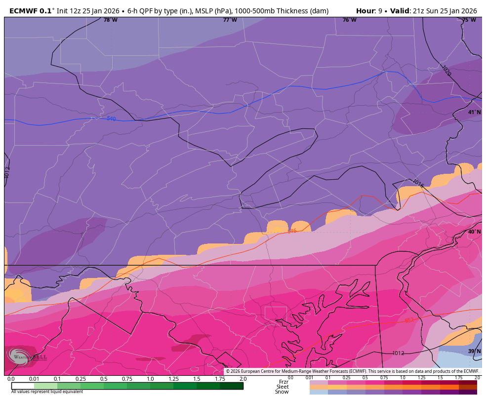
6z Euro & 6z Euro AI for this coming weekend. Might be time to buckle up again…! -
Central PA Winter 25/26 Discussion and Obs
Blizzard of 93 replied to MAG5035's topic in Upstate New York/Pennsylvania
CTP is starting to ramp up the language for this weekend’s potential. KEY MESSAGE 2: Potential East Coastal Storm Threat this weekend There is a growing guidance signal for the development of a potentially impactful weekend coastal storm along the Eastern Seaboard. We will continue to monitor given risk of snow and wind impacts. -
Central PA Winter 25/26 Discussion and Obs
Blizzard of 93 replied to MAG5035's topic in Upstate New York/Pennsylvania
I just looked out again & there is steady light snow falling currently despite nothing showing on radar. -
Central PA Winter 25/26 Discussion and Obs
Blizzard of 93 replied to MAG5035's topic in Upstate New York/Pennsylvania
Radar looks to be filling in a bit to our southwest for our last round tonight. -
Central PA Winter 25/26 Discussion and Obs
Blizzard of 93 replied to MAG5035's topic in Upstate New York/Pennsylvania
Yes, 18z Euro looks good per Mid Atlantic thread. -
Central PA Winter 25/26 Discussion and Obs
Blizzard of 93 replied to MAG5035's topic in Upstate New York/Pennsylvania
Still mostly sleet with a few light flakes mixed in. Still Accumulating… -
Central PA Winter 25/26 Discussion and Obs
Blizzard of 93 replied to MAG5035's topic in Upstate New York/Pennsylvania
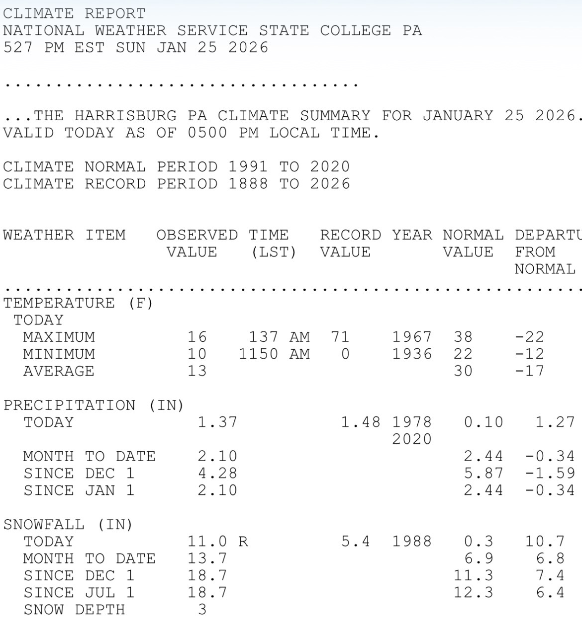
@canderson We are alive & well in the MDT measurement contest. The 5 pm climate summary has MDT at 11.0 today. If we get another inch or so with the last part of the storm, you & I will be battling for the crown! We will need to see what they officially put in the books overnight, but usually it’s close even if they make a slight adjustment.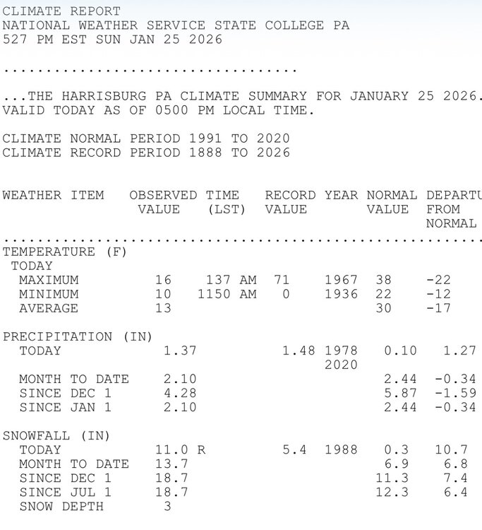
-
Central PA Winter 25/26 Discussion and Obs
Blizzard of 93 replied to MAG5035's topic in Upstate New York/Pennsylvania
-
Central PA Winter 25/26 Discussion and Obs
Blizzard of 93 replied to MAG5035's topic in Upstate New York/Pennsylvania
I’ll take! Looks like they refreshed the Warning a little over an hour ago. Winter Storm Warning URGENT - WINTER WEATHER MESSAGE National Weather Service State College PA 342 PM EST Sun Jan 25 2026 PAZ033>036-056-057-059-063>066-261230- /O.CON.KCTP.WS.W.0001.000000T0000Z-260126T1800Z/ Somerset-Bedford-Fulton-Franklin-Perry-Dauphin-Lebanon-Cumberland- Adams-York-Lancaster- Including the cities of Bedford, Hershey, Gettysburg, Chambersburg, Somerset, Lancaster, Lebanon, McConnellsburg, Harrisburg, York, Newport, and Carlisle 342 PM EST Sun Jan 25 2026 ... WINTER STORM WARNING REMAINS IN EFFECT UNTIL 1 PM EST MONDAY... * WHAT...Heavy mixed precipitation. Additional snow and sleet accumulation between 1 and 3 inches. Storm total snow and sleet accumulations between 9 and 12 inches, * WHERE...A portion of central Pennsylvania. * WHEN...Until 1 PM EST Monday. * IMPACTS...Travel could be very difficult to impossible. Widespread and prolonged travel disruptions are expected. * ADDITIONAL DETAILS...A mixture of moderate to heavy sleet and snow will occur into early this evening, before changing back to periods of lighter snow later this evening. Frigid temperatures and wind chills are expected during and after the winter storm. Some blowing and drifting snow is possible, mainly after daybreak Monda -
Central PA Winter 25/26 Discussion and Obs
Blizzard of 93 replied to MAG5035's topic in Upstate New York/Pennsylvania
I’ve picked up an additional 1.5 of mostly sleet & a little snow with the early afternoon mixing. My Marysville combined total as of 4:30 pm is 9.0” Moderate sleet is still ongoing. -
Central PA Winter 25/26 Discussion and Obs
Blizzard of 93 replied to MAG5035's topic in Upstate New York/Pennsylvania
Latest HRRR says Harrisburg area could flip back to a little snow over the next couple of hours as the mix line sags south a bit. -
Central PA Winter 25/26 Discussion and Obs
Blizzard of 93 replied to MAG5035's topic in Upstate New York/Pennsylvania
But do you or anyone have a link to the correlation coefficient radar? -
Central PA Winter 25/26 Discussion and Obs
Blizzard of 93 replied to MAG5035's topic in Upstate New York/Pennsylvania
Do you have a link to this? I can’t find it on CTP’s page. Any signs of it sagging back south a bit? -
Central PA Winter 25/26 Discussion and Obs
Blizzard of 93 replied to MAG5035's topic in Upstate New York/Pennsylvania
Does anyone know how the “snow depth” measurements work on the regional observations at MDT? The 7 am snow depth showed 3 inches and the 1 pm snow depth said 7 inches. Do they “clear the board” every 6 hours and start fresh? With 1.1 QPF through 1 pm, there should no way MDT only has a depth of 7 at this time right? -
Central PA Winter 25/26 Discussion and Obs
Blizzard of 93 replied to MAG5035's topic in Upstate New York/Pennsylvania
Dare I say… best rate & flake size now in Marysville! -
Central PA Winter 25/26 Discussion and Obs
Blizzard of 93 replied to MAG5035's topic in Upstate New York/Pennsylvania
Lol, you asked me to post it!
-
Central PA Winter 25/26 Discussion and Obs
Blizzard of 93 replied to MAG5035's topic in Upstate New York/Pennsylvania
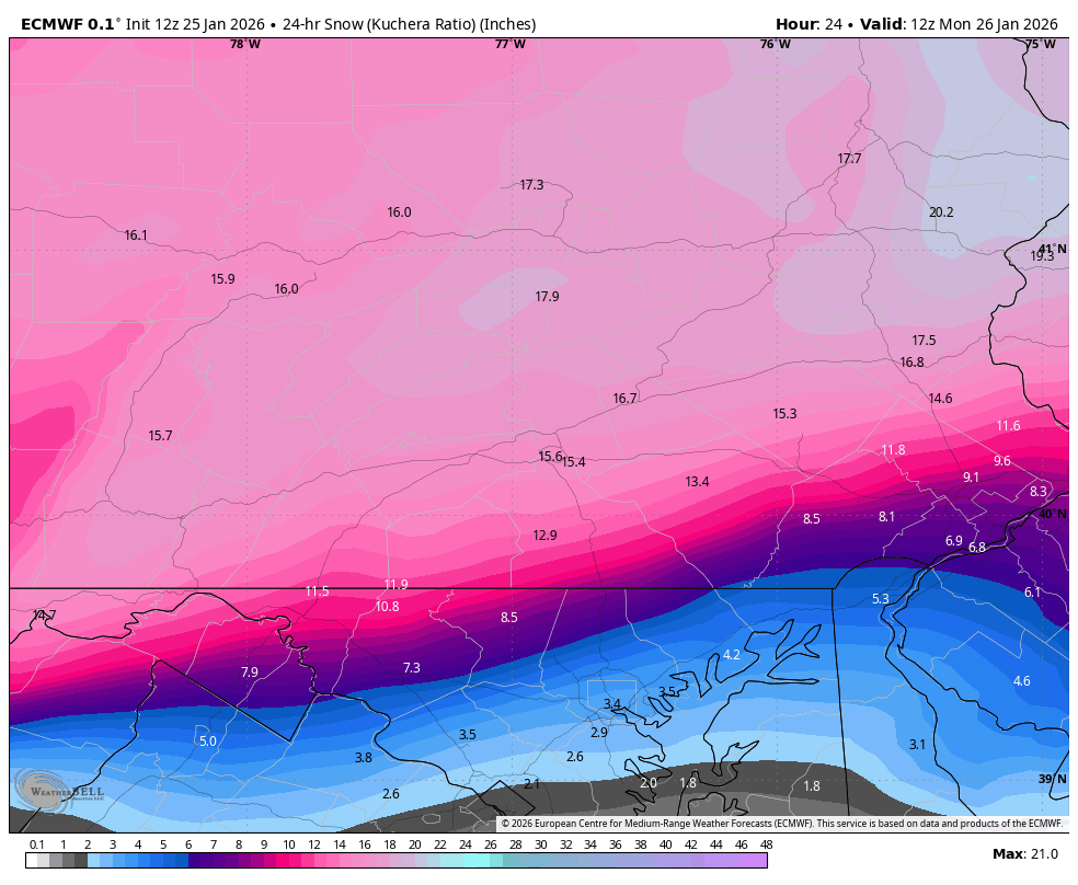
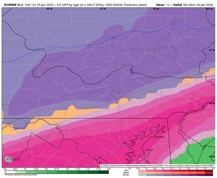
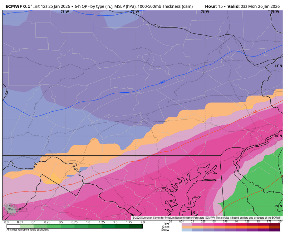
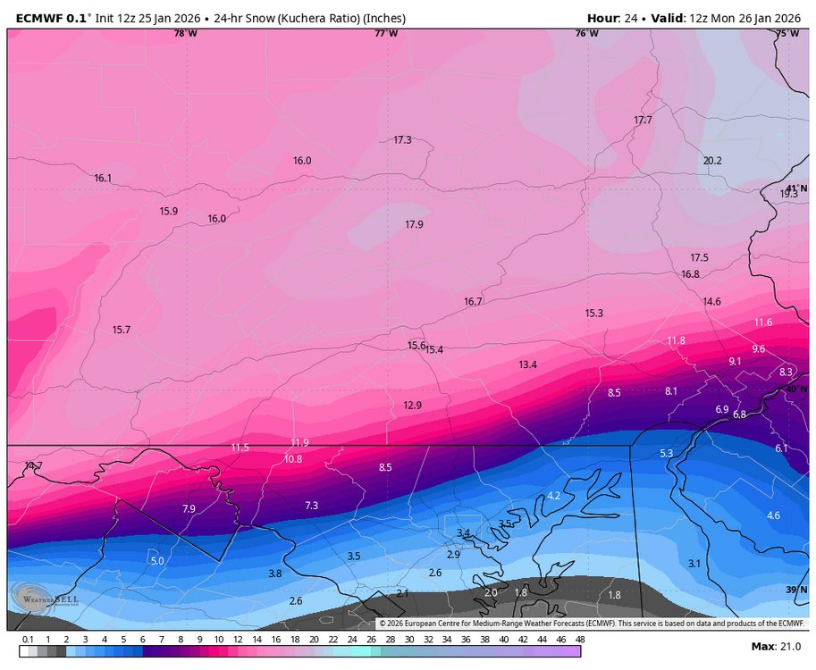
12z Euro
-
Central PA Winter 25/26 Discussion and Obs
Blizzard of 93 replied to MAG5035's topic in Upstate New York/Pennsylvania
Back to mostly snow in Marysville!!! Don’t eff with the Euro, lol! -
Central PA Winter 25/26 Discussion and Obs
Blizzard of 93 replied to MAG5035's topic in Upstate New York/Pennsylvania
Do you want the snow map or the frames with precip types? -
Central PA Winter 25/26 Discussion and Obs
Blizzard of 93 replied to MAG5035's topic in Upstate New York/Pennsylvania
For what it’s worth, the 12z Euro didn’t back down and still had predominantly snow from the turnpike on to the north in the LSV this afternoon & evening and stuck to its 12 to 15 total. Not sure what that means, if anything At this point.