Blizzard of 93
-
Posts
13,024 -
Joined
-
Last visited
Content Type
Profiles
Blogs
Forums
American Weather
Media Demo
Store
Gallery
Everything posted by Blizzard of 93
-
12z regular EPS does not agree with its Op run whatsoever. Here is the 3 day snow map as of next Monday am.
-
Central PA Winter 25/26 Discussion and Obs
Blizzard of 93 replied to MAG5035's topic in Upstate New York/Pennsylvania
Hopefully your trash cans are secure, Lol! -
Central PA Winter 25/26 Discussion and Obs
Blizzard of 93 replied to MAG5035's topic in Upstate New York/Pennsylvania
Interesting, yet MDT didn’t get it right. -
Central PA Winter 25/26 Discussion and Obs
Blizzard of 93 replied to MAG5035's topic in Upstate New York/Pennsylvania
The 6z AI Euro & AI GFS remain interested in the next Sunday & Monday period for a Winter storm chance.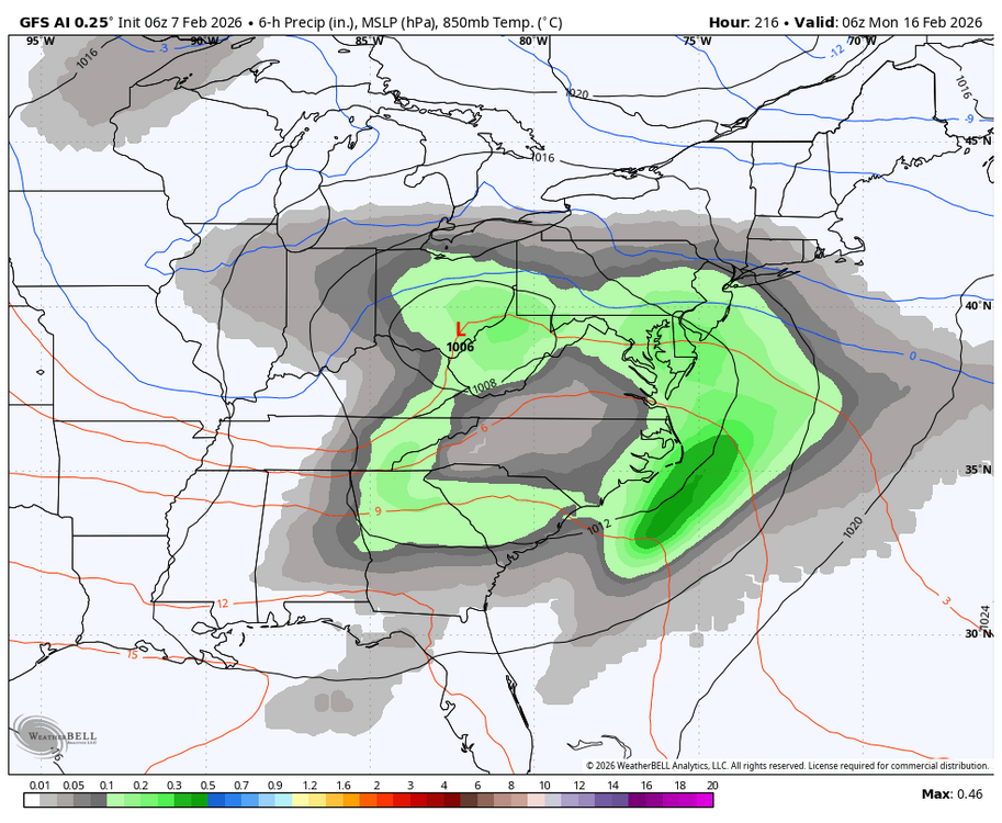
-
Central PA Winter 25/26 Discussion and Obs
Blizzard of 93 replied to MAG5035's topic in Upstate New York/Pennsylvania
-
Central PA Winter 25/26 Discussion and Obs
Blizzard of 93 replied to MAG5035's topic in Upstate New York/Pennsylvania
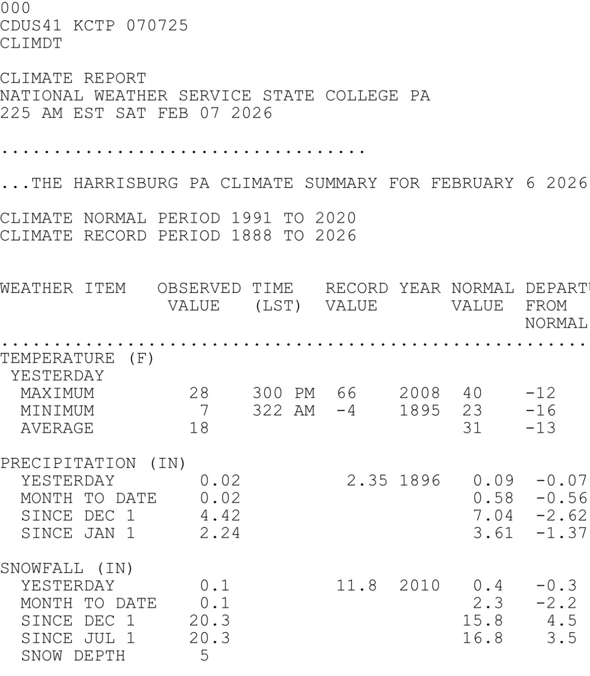
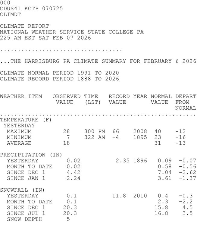
Not for actual snowfall. That is snow depth you are referring to: -
Central PA Winter 25/26 Discussion and Obs
Blizzard of 93 replied to MAG5035's topic in Upstate New York/Pennsylvania
I’ve been happy with MDT’s measurements this season so far, but I’m a bit puzzled by their measurement yesterday. They recorded .02 of precip but only recorded .1 of snow, despite temperatures well below freezing. It doesn’t matter much in the grand scheme of things, but, for example if we end up sitting at 29.9 of snow for the season, that could have been the tenth of snow to push us to the 30 mark. These little events all add up & details matter… -
Sorry, I need coffee! I thought you were referring to the snow maps.
-
You need to show a few day window for timing differences at this range…
-
Central PA Winter 25/26 Discussion and Obs
Blizzard of 93 replied to MAG5035's topic in Upstate New York/Pennsylvania
Light snow actively was falling the entire way between Marysville & Palmyra. Light snow & 23 currently in Palmyra. -
Central PA Winter 25/26 Discussion and Obs
Blizzard of 93 replied to MAG5035's topic in Upstate New York/Pennsylvania
I just got to Palmyra for my daughter’s indoor softball league game & the main roads appeared to be fine, however, there was a major accident on the west bound side of 322 outside of Harrisburg towards Hummelstown. There was a tractor trailer on its side. There were police & fire trucks on the scene & responding. I will likely be taking a different route home, because I imagine it will take awhile to clear that area. if you are venturing out, please be careful. Roads are getting slick! -
Central PA Winter 25/26 Discussion and Obs
Blizzard of 93 replied to MAG5035's topic in Upstate New York/Pennsylvania
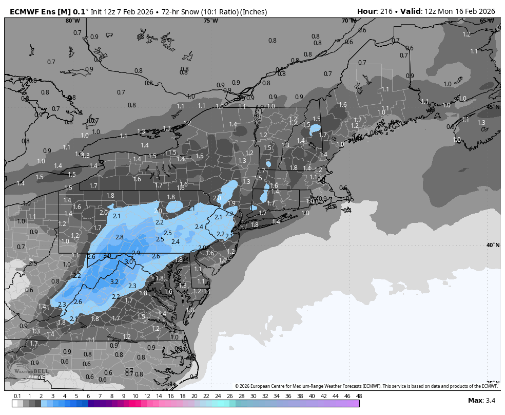
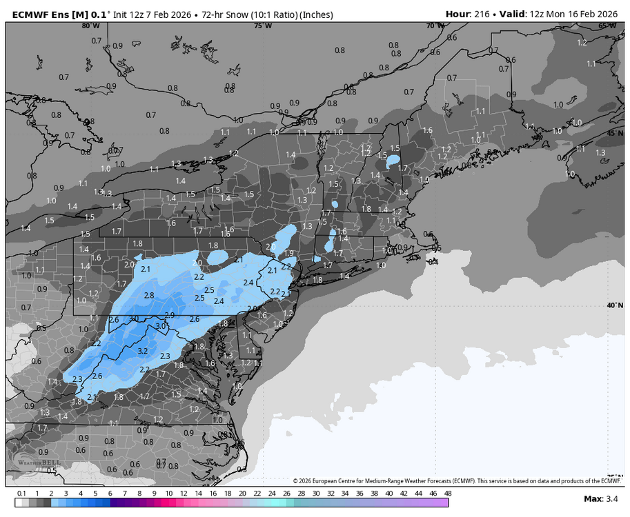
Here is the AI EPS 72 hour snow from 2/13 am to 2/16 am. Here is also the 50th percentile map through 2/13 am & through 2/16 am. Very little snow falls before 2/13, so the window for next weekend is evident at least in terms of snow maps. -
Here is the AI EPS 72 hour snow from 2/13 am to 2/16 am. Here is also the 50th percentile map through 2/13 am & through 2/16 am. Very little snow falls before 2/13, so the window for next weekend is evident at least in terms of snow maps.
-
Central PA Winter 25/26 Discussion and Obs
Blizzard of 93 replied to MAG5035's topic in Upstate New York/Pennsylvania
Hang in there man, Only a month or so to go until Spring. CTP had this today in their discussion about a little relief next week… KEY MESSAGE 3: Moderating temperatures during the second week of February For those looking for a break in the cold pattern, here you go. Confidence continues to increase that temperatures will moderate during the second week of February and climb back to seasonal levels or near the historical average for early to mid February. This "warmup" puts mixed precipitation on the table with the next weather system that could arrive Wed/Thu next week. The guidance has come into better agreement concerning the precip pattern evolution with best odds around the middle of next week. -
Central PA Winter 25/26 Discussion and Obs
Blizzard of 93 replied to MAG5035's topic in Upstate New York/Pennsylvania
I just noticed that MDT got down to 2 degrees this morning. -
Central PA Winter 25/26 Discussion and Obs
Blizzard of 93 replied to MAG5035's topic in Upstate New York/Pennsylvania
Both the 18z AI Euro & AI GFS have a potential Winter storm chance near President’s Day this run. -
Central PA Winter 25/26 Discussion and Obs
Blizzard of 93 replied to MAG5035's topic in Upstate New York/Pennsylvania
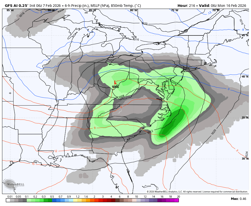
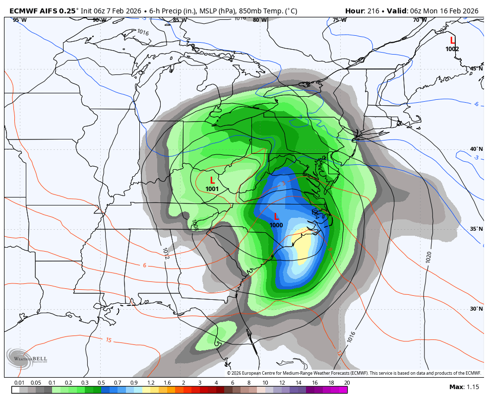
6z GFS for next weekend has a snow to mix/rain back to snow long duration scenario for CTP. Long way to go & many developments still to come in the upcoming days as we continue to track the potential.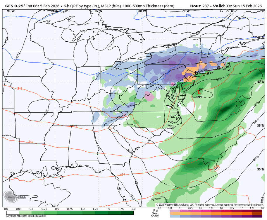
-
Central PA Winter 25/26 Discussion and Obs
Blizzard of 93 replied to MAG5035's topic in Upstate New York/Pennsylvania
Low of 7 in Marysville. -
Central PA Winter 25/26 Discussion and Obs
Blizzard of 93 replied to MAG5035's topic in Upstate New York/Pennsylvania
Lots of shovel & temperature talk today… But no one bothered to post the 12z Euro for next weekend’s chance…Lol! This run shows heavy snow to mix for most of us before a change back to snow. The low took a somewhat inland track, which brought on the mixing this run. Long way to go… -
Central PA Winter 25/26 Discussion and Obs
Blizzard of 93 replied to MAG5035's topic in Upstate New York/Pennsylvania
Bottom line is that Next weekend is still a period of interest that needs monitored for a possible Winter storm chance. -
Central PA Winter 25/26 Discussion and Obs
Blizzard of 93 replied to MAG5035's topic in Upstate New York/Pennsylvania
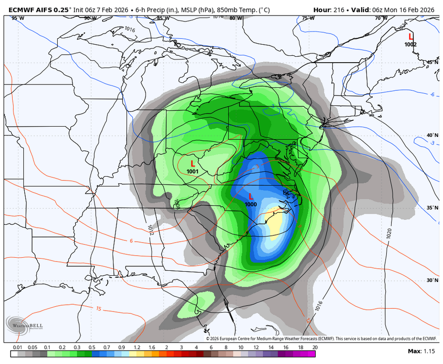
The 6z AI GFS actually keeps the low mostly to our south this run in response to the blocking. -
Central PA Winter 25/26 Discussion and Obs
Blizzard of 93 replied to MAG5035's topic in Upstate New York/Pennsylvania
Likely way overdone to say the least this run, but the 6z GFS had the general idea of a low tracking towards Ohio & then forming a secondary in response to the blocking in the Northeast. The good recent off & on runs the last few days of the Euro & the AI models had this same general idea. The 6z GFS just gets the coastal going a little earlier & then rapidly strengthens it, producing a historic result, that is of course unlikely. -
Central PA Winter 25/26 Discussion and Obs
Blizzard of 93 replied to MAG5035's topic in Upstate New York/Pennsylvania
12z EPS & AI EPS also have the Winter storm signal for Valentine’s weekend. -
Central PA Winter 25/26 Discussion and Obs
Blizzard of 93 replied to MAG5035's topic in Upstate New York/Pennsylvania
18z GFS had an interesting solution for a Valentine’s weekend Winter storm chance. -
Central PA Winter 25/26 Discussion and Obs
Blizzard of 93 replied to MAG5035's topic in Upstate New York/Pennsylvania
Long range GFS & Euro Op runs are starting to entertain the idea of a Valentine/PD weekend Winter storm chance, just like their AI versions have shown over the last couple of days at times.