Blizzard of 93
-
Posts
13,037 -
Joined
-
Last visited
Content Type
Profiles
Blogs
Forums
American Weather
Media Demo
Store
Gallery
Everything posted by Blizzard of 93
-
If we want to talk long range global Op models, the 3 main globals are all cold at day 10 for New Year’s Eve.
-
Lol…because one GFS Op at day 16 is to be taken seriously…? Come on now…
-
18z GEFS looks loaded with potential for that first week of January.
-
Best GEFS run of the year. @mitchnick has been waiting for this. Good to see the 2 inch line down to Richmond.
-
Good to see the Op recognizing the upcoming pattern in early January.
-
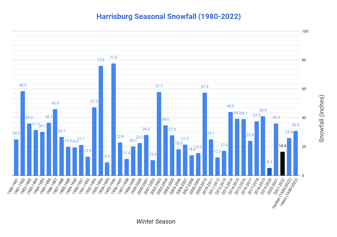
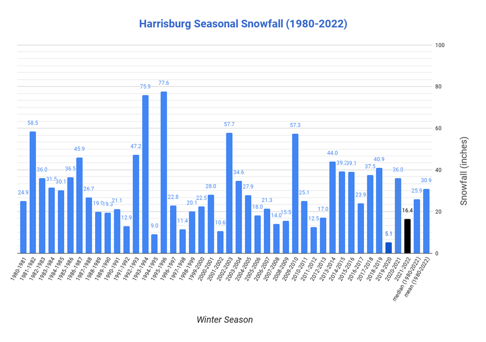
Lots of ups & downs with seasonal snowfall over the decades in Harrisburg. Recent seasonal snowfall history since 2010 shows that Harrisburg has had 7 seasons with above normal snow & 7 seasons with below normal snow.
-
The 12z Euro control has a low near VA beach the night of January 3rd.
-
26 in Marysville
-
The 0z Euro Control also has a good looking storm for January 2nd that takes a very favorable track. Yes, I know…long range Control run, but nice to see storms like this starting to show up in the upcoming pattern.
-
The 0z Euro Control also has a good looking storm for January 2nd that takes a very favorable track. Yes, I know…long range Control run, but nice to see storms like this starting to show up in the upcoming pattern.
-
-
-
The 0z GFS shows what the upcoming pattern change could deliver to start off the New Year.
-
The 0z Canadian says the the storm late next week still might not be resolved.
-
Lol, that’s right… because you have never ever shoveled snow in downtown Harrisburg!
-
Post of the year! Great, great post that should lead off every page on here!
-
Flurries in Marysville currently.
-
There’s still a good consensus among the 3 global ensembles on the general pattern for the 5 day period at the end of their 0z runs.
-
What are your thoughts on the potential of the upcoming pattern change?
-
Thanks & here’s to better days coming soon!
-
Thanks, we all have our own different personalities & experiences to share.
-
Many people forget the Winter of 20-21. MDT had 2 snowstorms that measured over 10 inches and the seasonal total was an above average 36 inches.
-
You’re probably right. Hopefully this pattern change delivers.
-
It’s not like I make stuff up! I post models & maybe make a few comments to support what I post. But I guess that’s just bad posting? Give me a freaking break!
-
It’s unbelievable that a long time poster like me that provides quality model content & general positive vibes on here is getting ripped! Strange place…