-
Posts
765 -
Joined
-
Last visited
Content Type
Profiles
Blogs
Forums
American Weather
Media Demo
Store
Gallery
Everything posted by *Flash*
-
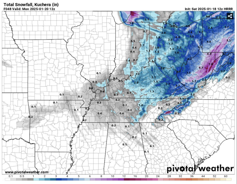
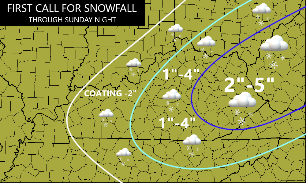
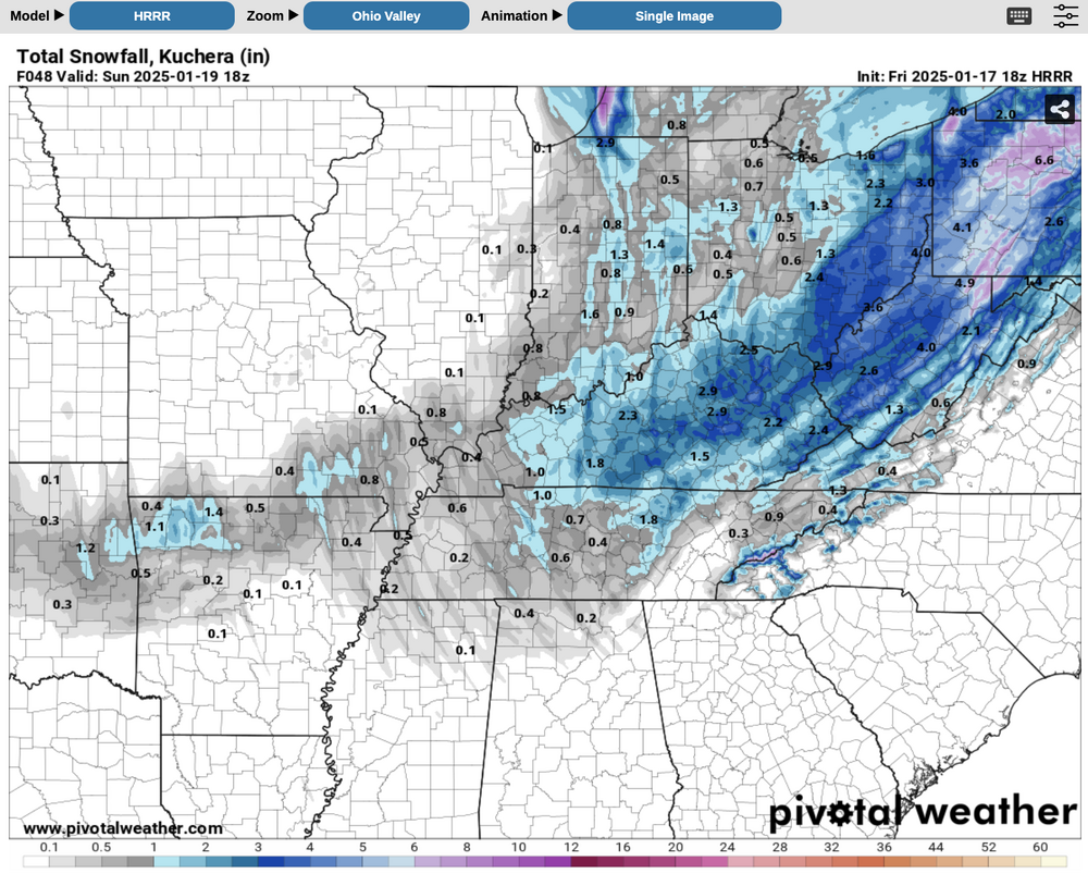
HRRR has me jonesin’. If it’s right, let’s freakin’ go! Like Jax, thought this was an OV special riding into church this morning. 925’s have me nervous but 850’s should do the trick.
- 750 replies
-
- 5
-
-
- snow elk
- wooly worm
-
(and 1 more)
Tagged with:
-
A few quick points in passing (Warning: My thoughts yield to west/middle TN; east TN posters can add their tweaks as needed): 1) Before I forget to say it, the transparency, humility, and corporate knowledge base on this board is why I believe it's the best of the main forum options. Discussions that compel chips towards the center of the table, that's how we all learn and grow in understanding together. A corporate job well done there. 2) I'm learning more and more how each winter setup is truly unique, a snowflake unto itself. Last decade, we saw wintry episodes that rarely featured north American teleconnection alignment between the primary players (EPO/PNA/AO/NAO). During this time, the local weather communities were adjusting to what we needed to see in our respective valleys within the context of a -PDO. The way my memory works, I recall events by themes and tropes: 2010-11 - How middle/east TN can score when the -NAO overwhelms the pattern. Second strongest Niña in the 21st century. Only 2007-08 ranks higher. 2011-12 - Pure misery on the heels of a great two-year stretch. Creds: PDO/MJO/SSWE. 2012-13 - Like the prior winter by extension but hope abounds because... 2013-14 - ...we finally see a jackpot setup for east TN. Partial creds: +TNH and PV appearances. #snowdome winter for west/middle TN. Bad history for BNA as the DJF period ranks #1 for total snow/mean temperature departure from average department. Great example of how suppression can kill chances for the western half when the Atlantic quenches the storm track. 2014-15 - My friend, the -EPO, makes a cameo and offsets the +NAO. To Carver's point, the February/March 2015 storms were mostly hits for western/middle TN with the greatest totals near the TN River. This year taught me how the Pacific can help parts of the state out, especially as the -PDO weakens. The AMO also dips briefly into negative territory. 2015-16 - Winter. Storm. Jonas. A jackpot storm for northern middle TN during a historic two-week stretch that proves to be weather loan forgiveness for 2013-14. For BNA, the 27th snowiest winter took place in the 9th warmest winter courtesy of a temporarily improved PDO. Proof of what one storm can do even when the December prior is the epitome of blowtorch. Creds: SUPER Niño (Modiki) ENSO. 2016-17 - Pretty sure everything sucked this winter. Typing the years out hurts my eyes. I'm just going to move on... 2017-18 - Dry/cold December. Slight +PNA/-EPO, again, is the solve for middle TN in mid January despite a consistent +NAO. SSWE takes place too late and gives us a cold spring. Plenty of KY snow in early March as the MJO amplification increases. Tough pills to swallow as a two-week adjustment in timing could have resulted in a top 25 snow event for many on the forum. 2018-19 - Rich man's 2016-17. PNA starts positive but quickly goes negative. +NAO fails to go negative until the spring. PDO is weak but is overrun by other teleconnections. Some nice hits northwest of TN into MO/KY/IL. Lots of MJO amplification fluctuation throughout. Second consecutive cold spring. More misery. 2019-20 - See 2016-17. This winter gets a pandemic pass. 2020-21 - The rise of the -EPO delivers a brutal late winter blow to points west of the plateau. The NAO starts negative in January but rises throughout the rest of winter. A goldmine February for the western 2/3rd's of the state that ultimately saves winter. 2021-22 - A hookup between 2015-16 and 2021-22 and another win for the -EPO/+PNA amidst a +NAO. First two weeks for middle TN see not one, not two, but three notable snow events sandwiched in just a two-week stretch. 2022-23 - A tutorial on how winter can be screwed for TN when the NAO cooperates. A true one-hit wonder and another winter to forget overall. I'll let recency bias do the talking here. 3) All of this said, we can see how last January was our mini-perfect storm the way everything came together (almost) statewide. As Carver mentioned, the award goes to the -NAO and is the testament to east TN capitalizing. Generally speaking, west/middle TN can still root for a -NAO despite greater impacts east of the plateau assuming other factors preserve a flatter flow as opposed to SW --> NE. Still, the -EPO being more of a win for west/middle TN cannot be denied despite the limited sample size above. Just my $0.02. Selah.
- 750 replies
-
- 5
-
-
-
- snow elk
- wooly worm
-
(and 1 more)
Tagged with:
-
I was thinking the same thing, Matthew. The consolation prize to #wintercancel (being facetious there), is the split flow pattern helping keep us wet. When the year started, I recall some having concerns we wouldn’t bust the drought heading into spring. I look forward to the next Drought Monitor on Thursday to see how far we’ve come in recent weeks.
- 750 replies
-
- 2
-
-
- snow elk
- wooly worm
-
(and 1 more)
Tagged with:
-
If we lose the EPO and it flips +, I say it’s under 50/50 though it depends on where you live. Not sure if winter can return if the MJO and EPO aren’t in our corner. We’re asking a whole lot from the Atlantic side at that point. ssstwitter.com_1707587255443.mp4
- 750 replies
-
- snow elk
- wooly worm
-
(and 1 more)
Tagged with:
-
Yeah, the GFS hasn’t been trending well this week. Hopefully, there is some error involved as Carver pointed out.
- 750 replies
-
- snow elk
- wooly worm
-
(and 1 more)
Tagged with:
-
I know it’s been shared before but can you remind some of us where we can find these verification scores? I think it would be a fascinating study to analyze model scores by the six ENSO patterns.
- 750 replies
-
- 1
-
-
- snow elk
- wooly worm
-
(and 1 more)
Tagged with:
-
Officially lost the finishing touches to what was our coldest week since 1994 (30 years) and the longest snow duration (1+") in 46 years. Why not conclude matters with another timelapse! a
-
Update to my post above: If BNA maintains another 1+” day by midnight, you would have to go all the way back to January 13-29, 1978 to find a longer duration. Clearly, Winter Storm Heather is one for the record books!
-
Going through past BNA CF6's today. Unless I'm missing something, I believe this is the longest stretch of measurable snow (1"+) on the ground in almost 40 years! January 1988 and February 1996 came close but both occurrences didn't last a full week at least at the airport.
-
January Medium-Long Range Discussion
*Flash* replied to Holston_River_Rambler's topic in Tennessee Valley
Man, that is one happy pattern!- 1,263 replies
-
- 2
-
-
January Medium-Long Range Discussion
*Flash* replied to Holston_River_Rambler's topic in Tennessee Valley
For the first time in my life, I started singing, '♫ Here comes the sun ♫'...when it was single digits outside. A fitting tribut to January 2024 once all is said and done.- 1,263 replies
-
- 3
-
-
January Medium-Long Range Discussion
*Flash* replied to Holston_River_Rambler's topic in Tennessee Valley
Another winter, another fascinating teleconnection tug-of-war! From what I'm hearing and seeing, we got a decent PAC again but decreasing favor with the MJO/NAO/ENSO. I think thaw week will bring some critical clarity. Like many, I agree with Carver and others who are shining the light on February's second half. Personally, I'm tempted to throw climo out the window given a) expectations have generally been 1-2 weeks delayed since met winter started and b) the pattern has been slightly more fluid than progressive. With so many question marks surrounding the 'decreasing favor' elements mentioned above, I'm tempted to yield to the most consistent signals. Netting it all out for our part of the world, not seeing evidence of long-term PAC troughing and SER expands the tent pegs of our playing field enough for me to believe strong blocking will be back. The questions to me boil down to the magnitude of stratospheric warming/timing, if a strong -EPO/+PNA can offset wherever the MJO eventually fades into, and can we preserve moisture supply the next time cold air invades. Regardless, it will be interestoing to see where the next arctic amplification axis sets up after our 2-3 week warm-up. TN was in the perfect spot this last go-around as noted by many of our metros being some of the coldest spots in the entire conus a few morning ago. P.S. For all your guys in NC, I'm starting to feel guilty. If it's any consolation, I wouldn't mind you guys getting the next banger to end your misery.- 1,263 replies
-
- 2
-
-
Bonus snow showers swinging through northern middle TN this morning. Any exposed surfaces are getting an extra layer of dippin' dots. 8:15 am CT Update: DBZ's have really picked up the last few frames so I wonder if there's any 'lake effect' resulting from Kentucky Lake/Lake Barkley?
-
OHX just issued a WWA for most of the midstate. Bizarre looking advisory area based on the probabilities. Like Bearman mentioned, hate that most of this may be FZRA. While surface temps may verify on the under, I don't see thermals a couple thousand feet up cooperating. What a mess! Hopefully, trends will be wetter or snowier.
- 372 replies
-
- 3
-
-
- cold
- arctic blast
-
(and 1 more)
Tagged with:
-
January 15th-17th 2024 Arctic Blast/Snow Event
*Flash* replied to John1122's topic in Tennessee Valley
-
January 15th-17th 2024 Arctic Blast/Snow Event
*Flash* replied to John1122's topic in Tennessee Valley
Yeah, this is up there for me along with 2/4/96, 1/16/03, and 1/22/16. Definitely a top 3-4 snow in 30 years living in TN. We had great winter storms in 1994, 2008, 2010-11, and February 2015/2021...but many of them had ice cut into totals. In terms of pure snow, this is up there with the greatest hits. -
January 15th-17th 2024 Arctic Blast/Snow Event
*Flash* replied to John1122's topic in Tennessee Valley
Up to 7" of snow in the Bluff as of 1:30 pm CT. -
January 15th-17th 2024 Arctic Blast/Snow Event
*Flash* replied to John1122's topic in Tennessee Valley
So, I know the event is still ongoing...and I need to get caught up on about 15 pages of comments. In terms of modeling W's and L's, how are we breaking down performance? Certainly, NOT a win for the Euro at least for my area... -
January 15th-17th 2024 Arctic Blast/Snow Event
*Flash* replied to John1122's topic in Tennessee Valley
Good morning! I woke up at 6:15 pm CT to 4.1" in White Bluff. We're now at 5.5-6". MUCH more than I expected... -
January 15th-17th 2024 Arctic Blast/Snow Event
*Flash* replied to John1122's topic in Tennessee Valley
Judging by the reflectivity and what's fallen so far, should be at an inch within the next 30. Ratios doing there thing here. -
January 15th-17th 2024 Arctic Blast/Snow Event
*Flash* replied to John1122's topic in Tennessee Valley
Snow officially underway in White Bluff. A few tenths of an inch already! -
January 15th-17th 2024 Arctic Blast/Snow Event
*Flash* replied to John1122's topic in Tennessee Valley
CMC and HRRR with slight NW trends. For Nashville metro, you take the 15z HRRR over 12z 10/10. Hopefully, the extent of the NW precip shield expands to include more of the populace. Still worried about dry air north of 40/west of 65. Regardless, that 700 jet will be howling over my location. -
January 15th-17th 2024 Arctic Blast/Snow Event
*Flash* replied to John1122's topic in Tennessee Valley
Updated call from my guy, Bobby Boyd. This looks about right. @jaxjagman, I'll be riding this out about 4-5 miles SE of Brentwood. -
January 15th-17th 2024 Arctic Blast/Snow Event
*Flash* replied to John1122's topic in Tennessee Valley
You're welcome! -
January 15th-17th 2024 Arctic Blast/Snow Event
*Flash* replied to John1122's topic in Tennessee Valley