

CCHurricane
-
Posts
540 -
Joined
-
Last visited
Content Type
Profiles
Blogs
Forums
American Weather
Media Demo
Store
Gallery
Everything posted by CCHurricane
-
First line swinging through Cape Cod with a decent punch.
-
Surprising to see Logan only recorded / reported 1.3” of additional accumulation from 1PM yesterday until the end of the snows early this morning... Would have for sure thought they added a few additional inches given Radar, temp profile and minimal winds.
-
Last gasp on the shores of Cape Cod. 4-5 inches of fluff.
-
Someone’s finally shaking the snow globe down on Cape Cod
-
Solid 3” here in a downtown Boston
-
Not sure about the weenie tag...simply making a factual statement. IMBY frustration/depression is popping up all over this board!
-
00Z Euro initializing with a decent bump NW in precip field and LP pressure.
-
The Euro surprisingly looks better for southeastern MA... EDIT: annnnnd from 72->78 hours it fell apart.
-
While leading up to this weekend's storm, the GFS was everyone's favorite punching bag. While it certainly made mistakes as it related to QPF output, it's idea on MSLP positioning was more right than most. To simply disregard it due to some past experience is the opposite of what you should be doing as a forecaster. Take your emotional biases out of the equation, or better yet maintain a log of how your tier model lists have performed from a QPF and MSLP location perspective, and I'm sure you'll see that a change is in order. Best of luck!
-
In terms of the LP statement, I believe it was the winning model, but wrong on QPF output, which I believe the Euro was most correct with. Will be interesting to see if this holds, or if it was simply a one-off event.
-

OBS/DISCO - The Historic James Blizzard of 2022
CCHurricane replied to TalcottWx's topic in New England
Good points, bottom fourth of snowpack was a pain to shovel. Told the story of our storm, wouldn’t doubt that settled a bit overnight. -
OBS/DISCO - The Historic James Blizzard of 2022
CCHurricane replied to TalcottWx's topic in New England
Will you be sending in a report? Around 16-17” here in Barnstable. That decent band between 4:30-5:30 seemed to curl over us which likely lead to an additional inch or two relative to you. -
OBS/DISCO - The Historic James Blizzard of 2022
CCHurricane replied to TalcottWx's topic in New England
Looks like no new reports came in to update Cape Cod totals which is a bit disappointing. Guess the NWS can only state what’s reported, but the 12” and 13” totals were measured with 3-5 hours of our best snow growth still to come. Likely ended up with 16-20” down here. -
OBS/DISCO - The Historic James Blizzard of 2022
CCHurricane replied to TalcottWx's topic in New England
Will be interesting to see how NWS Boston handles their final snow map. 2 of the 3 reported Cape Cod numbers are definitively before the best returns of the day occurred, where I’d expect another 3-6” was added. Solid recovery for a storm that had a difficult start down here due to temps. -
OBS/DISCO - The Historic James Blizzard of 2022
CCHurricane replied to TalcottWx's topic in New England
Probably around 18” here in Barnstable (Cape Cod). Drifty picture for full effect.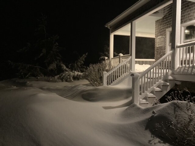
-
OBS/DISCO - The Historic James Blizzard of 2022
CCHurricane replied to TalcottWx's topic in New England
Thank Worcester band just won’t quit. Gotta think that’s +1”/hour stuff too based on radar. -
OBS/DISCO - The Historic James Blizzard of 2022
CCHurricane replied to TalcottWx's topic in New England
16-20” here on Cape Cod (upper and middle Cape), these last 4 hours have done wonders. -
OBS/DISCO - The Historic James Blizzard of 2022
CCHurricane replied to TalcottWx's topic in New England
Ocean enhanced snowfall, due to the north wind! -
OBS/DISCO - The Historic James Blizzard of 2022
CCHurricane replied to TalcottWx's topic in New England
OES starting to appear for Cape Cod. Keep it coming, need to make up for lost time early this AM. -
OBS/DISCO - The Historic James Blizzard of 2022
CCHurricane replied to TalcottWx's topic in New England
100%...That band before was 3-4” an hour easy. -
OBS/DISCO - The Historic James Blizzard of 2022
CCHurricane replied to TalcottWx's topic in New England
That band was reminiscent of Jan 2005. Congrats to those that experienced that for hours today! -
OBS/DISCO - The Historic James Blizzard of 2022
CCHurricane replied to TalcottWx's topic in New England
By FAR the heaviest stuff of the day here in Barnstable (Cape Cod). Finally under a heavy band, and with temps now at 25°F and this wind...complete whiteout. No more than 200-300ft visibility. Time to stack up some snow! -
OBS/DISCO - The Historic James Blizzard of 2022
CCHurricane replied to TalcottWx's topic in New England
Reinforcements just continue to rotate through. Cape Cap may finally get its own band here too. -
OBS/DISCO - The Historic James Blizzard of 2022
CCHurricane replied to TalcottWx's topic in New England
Oh for sure, we’ll be in this moderate stuff for a while, but the stuff on the other side of the Canal is the good stuff. At these temps, wouldn’t doubt 2-4” an hour. -
OBS/DISCO - The Historic James Blizzard of 2022
CCHurricane replied to TalcottWx's topic in New England
The Canal acting as Gandolf the Grey for Cape Cod getting in on the goodies. ”You shall not pass!”

