CCHurricane
-
Posts
540 -
Joined
-
Last visited
Content Type
Profiles
Blogs
Forums
American Weather
Media Demo
Store
Gallery
Everything posted by CCHurricane
-

December 14th - Snow showers or Plowable snow?
CCHurricane replied to Sey-Mour Snow's topic in New England
After a day of windless snow, really ramping up here on Cape Cod in the last hour. Gusting +30mph, sustained 15-20mph. Totally different feel outside, could make a run at +6 inches with these conditions. -
December 14th - Snow showers or Plowable snow?
CCHurricane replied to Sey-Mour Snow's topic in New England
HRRR continues to show a narrow band of 2-4 inches of extra snow for parts of Cape before this one wraps up. Very tight gradient however, 5-10 miles could be the difference between a dusting and higher amounts. -
December 14th - Snow showers or Plowable snow?
CCHurricane replied to Sey-Mour Snow's topic in New England
-
December 14th - Snow showers or Plowable snow?
CCHurricane replied to Sey-Mour Snow's topic in New England
Overlooking Nantucket Sound. Just crossed 3.0” in Barnstable. -
December 14th - Snow showers or Plowable snow?
CCHurricane replied to Sey-Mour Snow's topic in New England
2.8 in Barnstable on Cape Cod. Shooting for 5” with the bonus snows this evening. -
December 14th - Snow showers or Plowable snow?
CCHurricane replied to Sey-Mour Snow's topic in New England
Just under 3” in Barnstable. -
December 14th - Snow showers or Plowable snow?
CCHurricane replied to Sey-Mour Snow's topic in New England
Light snow has begun here in Barnstable on Cape Cod. -
December 14th - Snow showers or Plowable snow?
CCHurricane replied to Sey-Mour Snow's topic in New England
Juiced bump -
December 14th - Snow showers or Plowable snow?
CCHurricane replied to Sey-Mour Snow's topic in New England
Around the canal could steal 6”. -
Major Hurricane Melissa - 892mb - 185mph Jamaica landfall
CCHurricane replied to GaWx's topic in Tropical Headquarters
Pretty significant shift east on 18z spaghetti plots...no? -
Great visual to demonstrate why Erin has absolutely no chance for the East coast in the current setup.
-
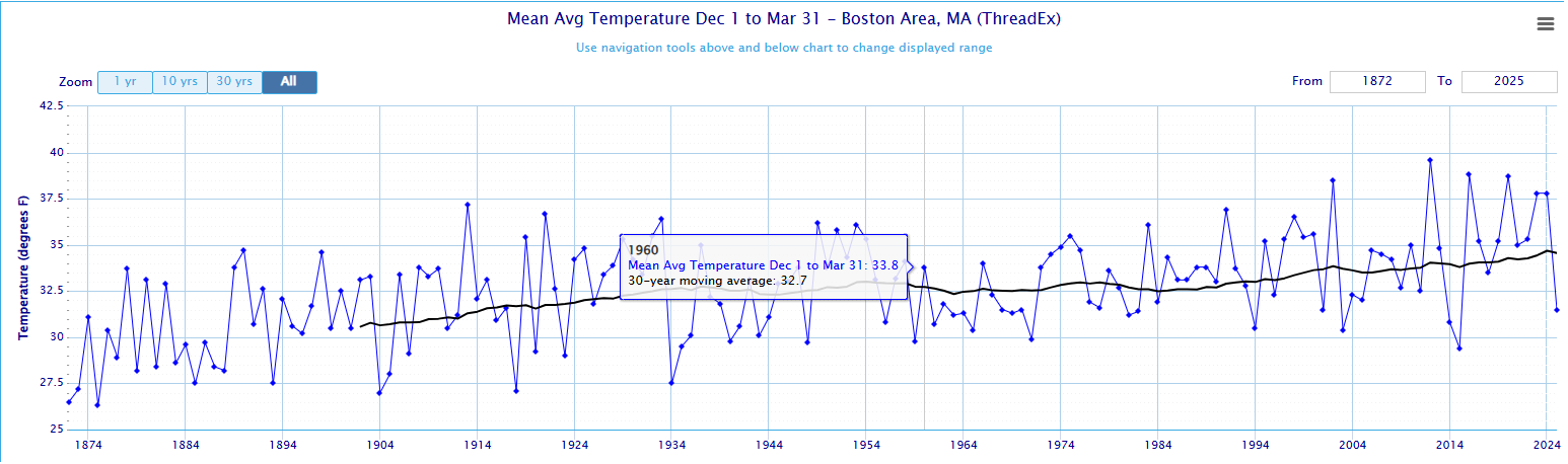
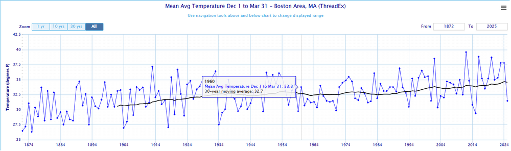
Black line is the 30-year rolling average; for BOS the 1930-1960 period was around 32.7F. Current "climate" is about +2F greater at 34.6F. Most notable is that pre-2002 and over the course of +125 years, BOS did not once see a Dec-Mar winter where avg. temps were +37.5F. Since 2002 we've seen 6 years +37.5... https://xmacis.rcc-acis.org/
-
12z NAM 3k just won't quit Cape Cod. A true scraper that feeds moisture and delivers a plowable event (3-6 inches) for most east of the Canal.
-
12z Euro has already backed off that solution unfortunately...
-
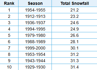
@RUNNAWAYICEBERG @HoarfrostHubb @40/70 Benchmark @ORH_wxman Lowest 10-Years of Snowfall for Worcester Area
-
December 2024 - Best look to an early December pattern in many a year!
CCHurricane replied to FXWX's topic in New England
Looks like this started on the earlier side. Will be interested to see how these bands move across and set up here on the Cape. Wellfleet and Yarmouth looks to be in a good spot at the moment. -
12/20-21 Clipper/Coastal Nowcast and Obs
CCHurricane replied to Boston Bulldog's topic in New England
Tapped out between 2-2.5” here in Barnstable. Once we lost the heavy echos of the main precip field, the accumulating snow went with it. All things considered, an enjoyable event with an interesting snowfall distribution from Boston to Cape Cod. -
12/20-21 Clipper/Coastal Nowcast and Obs
CCHurricane replied to Boston Bulldog's topic in New England
Just crossed 2” here in Hyannis / Centerville -
12/20-21 Clipper/Coastal Nowcast and Obs
CCHurricane replied to Boston Bulldog's topic in New England
Has been snowing here on Cape Cod since 5PM, best flakes of the evening so far.
-
12/20-21 Clipper/Coastal Nowcast and Obs
CCHurricane replied to Boston Bulldog's topic in New England
Can confirm. Just drove downtown BOS to split. Temp 31 -> 34, decent snow to rain. -
12/20-21 Clipper/Coastal Nowcast and Obs
CCHurricane replied to Boston Bulldog's topic in New England
Last night’s 00Z NAM from the top rope! A winter of positive busts, could you imagine? -
December 2024 - Best look to an early December pattern in many a year!
CCHurricane replied to FXWX's topic in New England
Thanks, checked but didn't see that on the forum page. -
December 2024 - Best look to an early December pattern in many a year!
CCHurricane replied to FXWX's topic in New England
Some nice snowfall here in Boston down to Weymouth. Is everyone just completely discounting the 12z NAM and this afternoon/evening threat? -
December 2024 - Best look to an early December pattern in many a year!
CCHurricane replied to FXWX's topic in New England
Would be quite the shift just 18 hours out. -
December 2024 - Best look to an early December pattern in many a year!
CCHurricane replied to FXWX's topic in New England
00z NAM turning back the clock a few days to show a nice moderate event tomorrow evening, with a Cape Cod jackpot if it can stay cold enough. Likely cut these numbers by 25-50%…but would be a beautiful and COLD weekend.