

CCHurricane
-
Posts
541 -
Joined
-
Last visited
Content Type
Profiles
Blogs
Forums
American Weather
Media Demo
Store
Gallery
Everything posted by CCHurricane
-
 00z Euro says take 'em down. Rough trends this evening for all outside of coastal areas.
 -
18z NAM with the rug-pull.
-
FWIW, 18z NAM about 50miles south of 12z thru 24 hours (simply looking at precip field formation)
-
Amazing the variance in what should be a similar Kuchera output...
-
Some snow showers here on Cape Cod. Dusting on the ground. Those nice echo’s over Cape Cod Bay…what a tease.
-
Some nice flakes down on Cape Cod about an hour ago.
-
A once in a lifetime storm for those in south eastern Massachusetts.
-
At least it's something - Jan 16th Snow/Sleet/Ice OBS Thread
CCHurricane replied to The 4 Seasons's topic in New England
A quiet snowfall before rain arrives on Cape Cod. -
unfortunately for southern spots, those precip types are incorrect. Soundings indicate much warmer temps.
-
Next week's threat on 12Z EURO goes POOF.
-
Talk about being disingenuous with this graphic. Selecting "24 Hours" misses most of the snowfall that occurred with this event. Despite personal biases and/or emotions, let's be accurate.
-
January 6-7, 2024 Winter Storm Obs Thread
CCHurricane replied to WxWatcher007's topic in New England
For southern New England coastline in particular, I feel like Euro and RGEM led the way with the right call that thermals would be too warm however. US Mesos didn’t catch on until just before precip started falling that there would be prolonged precip issues for eastern and south eastern MA. Mosaic approach always tough to piece together! -
January 6-7, 2024 Winter Storm Obs Thread
CCHurricane replied to WxWatcher007's topic in New England
If BOS can sneak out a 4”, I’ll be pleasantly surprised. -
January 6-7, 2024 Winter Storm Obs Thread
CCHurricane replied to WxWatcher007's topic in New England
Finally snowing here in BOS. Hope this banding is maintained for the next few hours. -
Pretty decent shift on the lower level temp profile for SE MA, particularly down near the cape. About a 5° difference at the surface.
-
Let me know what specific time period you are looking for and I can pull something down from this resource. Great at creating precipitation over time graphs, historical perspectives, etc. Boston and Worcester hubs likely have the most accurate data historically, yet as an example: This summer (June-August) was our wettings summer since 1955 June thru current day in September is 5th wettest all time. https://xmacis.rcc-acis.org/
-
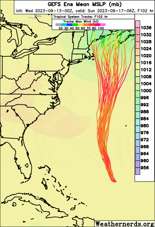
Getting the conversation back on topic... 18z GEFS actually shows an increased spread in LP track, with a southwest and northeast biased "stretch" around the mean. About half of the GEFS members are meaningfully closer to the eastern New England than the OP run.
-
GFS Ensemble Comparison September 13th - 00z vs. 06z vs. 12z
-
For sure a jog west compared to 12z, yet backed off some of the 18z juice. Regardless, still a high number of ensemble members showing a rough time for Cape and Islands even if there is no "landfall".
-
GFS Ensemble Comparison. 12z vs. 18z vs 00z
-
00z GFS has winds gusting at least +55mph out of the north throughout Cape Cod for over 24 hours. At it's peak gusting 75-90mph for +12 hours. Trying to find a trustworthy archive for wind data, but I would have to believe these would be the strongest prolonged sustained winds experienced since Bob in 1991. Toss in one of our wettest summers on record (using Boston data as proxy), full foliage, and a lack of meaningful pruning by mother nature in +30 years, and this would be a borderline disastrous outcome for north facing coastlines from Boston points south, and all of Cape Cod.
-
Imagine the Hurricane of 38’ happening today!?
-
Meteorologically speaking, this will likely deliver a once in a lifetime event for the area. Almost 100 years since the last Category 2 made landfall in the area. From a relative perspective, and while you never wish for a major hurricane to impact people's lives, yet thankfully this event will occur across some of the least populated areas of Florida. Posted in the Tropical HQ thread: ------- One for the history books if Idalia makes landfall as a major. Also looks like relative to history, the area has been long overdue. Apalachee Bay Hurricane Landfalls Hermine (2016) - Category 1 Alma (1966) - Category 1 Unnamed (1941) - Category 1 Unnamed (1935) - Category 2 Unnamed (1899) - Category 2 Unnamed (1886) - Category 2 Unnamed (1886) - Category 2 Unnamed (1882) - Category 1 Unnamed (1880) - Category 1 Unnamed (1873) - Category 1 Unnamed (1867) - Category 1 Unnamed (1852) - Category 2
-
Alma (1966) and the Unnamed Hurricane in 1886 are really the only two storms with a similar origin / track. Obvious not statistically significant, yet both storms only maintained or weakened upon their approach to the area, neither strengthened. The current climo is of course different than the past, particularly the extremely water temps, so we'll wait and see what happens with Idalia.


