CCHurricane
-
Posts
540 -
Joined
-
Last visited
Content Type
Profiles
Blogs
Forums
American Weather
Media Demo
Store
Gallery
Everything posted by CCHurricane
-

“Cory’s in NYC! Let’s HECS!” Feb. 22-24 Disco
CCHurricane replied to TheSnowman's topic in New England
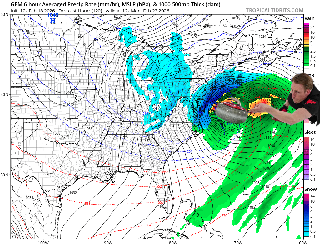
FWIW: while still VERY far away from GFS solution, UKMET 12z vs. 00z changed upper level look quite a bit. Having said that, end result could still be the same with as we've seen time and time again this winter re: vort messing with track well off the coast... -
“Cory’s in NYC! Let’s HECS!” Feb. 22-24 Disco
CCHurricane replied to TheSnowman's topic in New England
GEFS looks to be doubling down on OP run. -
“Cory’s in NYC! Let’s HECS!” Feb. 22-24 Disco
CCHurricane replied to TheSnowman's topic in New England
CMC going the way of the EURO. Not looking good for the GFS -
“Cory’s in NYC! Let’s HECS!” Feb. 22-24 Disco
CCHurricane replied to TheSnowman's topic in New England
Confirmation bias here we come. 18z ICON with the big bump NW for SE New England. -
“Cory’s in NYC! Let’s HECS!” Feb. 22-24 Disco
CCHurricane replied to TheSnowman's topic in New England
It won’t take much to move it another 50 miles…
-
“Cory’s in NYC! Let’s HECS!” Feb. 22-24 Disco
CCHurricane replied to TheSnowman's topic in New England
Nuke for the Cape...widespread 8-12 for most of SE New England. -
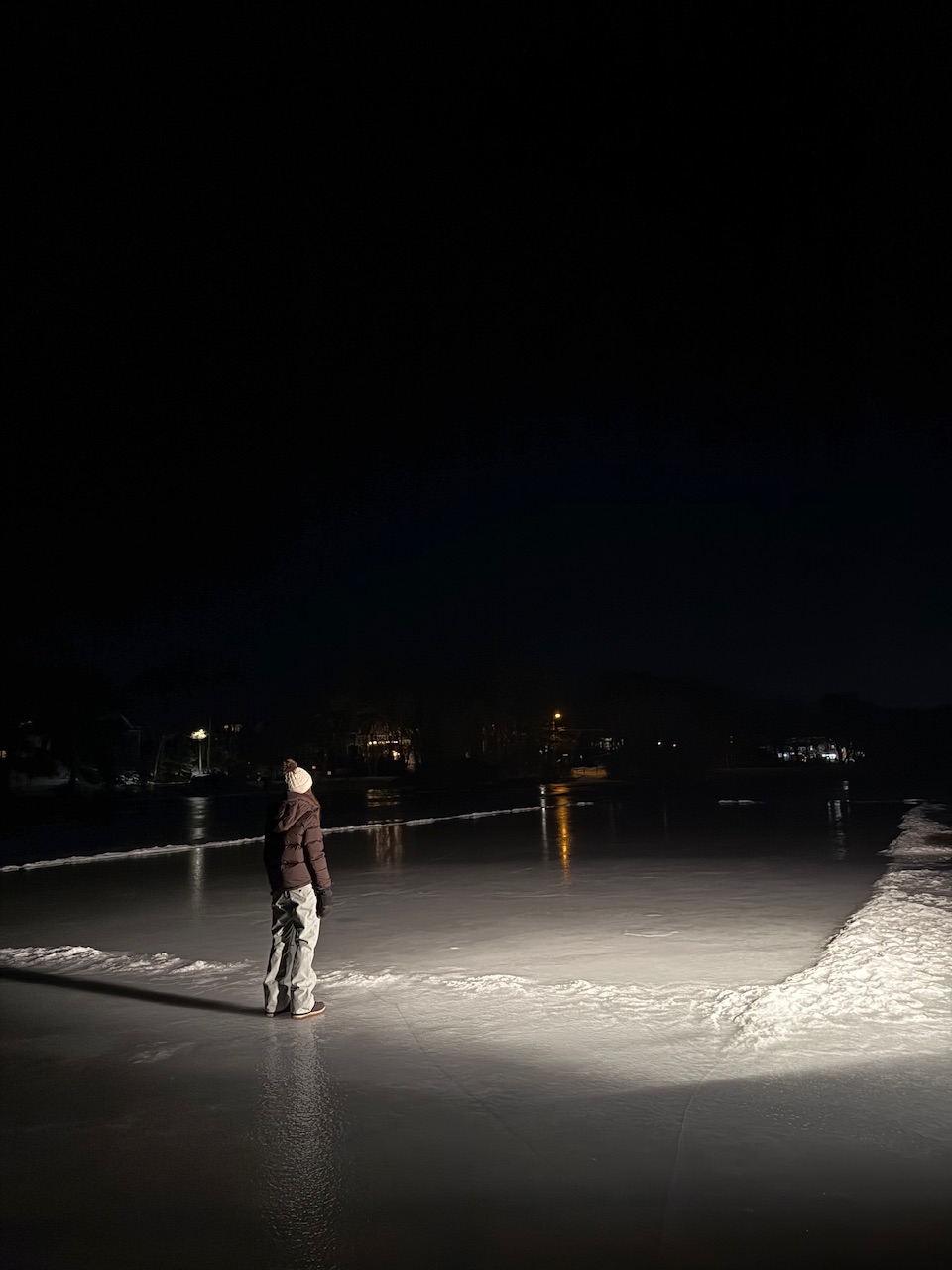
Likely the last flood of the pond this winter here on Cape Cod. What a stretch of cold…snowstorm from 3 weeks ago that dropped 15” still very much OTG. Since January 24th (22 days): 19 days with high temps below 33°F 18 nights with lows below 20°F 9 nights with lows below 10°F
-
In over +100 years (since 1918), Boston is looking to make a run at the longest stretch (19-days) where day-time highs failed to break above 34°F (currently at 16). Impressive stuff to not have a few days pop into the 40's, while also considering the potentially warm-biased Logan readings vs. history.
-
Friday February 6 FROPA / WINDEX small event
CCHurricane replied to HoarfrostHubb's topic in New England
So just a tad more than 1 inch. Gotta stay positive! Results to the north boded well for you. -
Looks light on Cape, have +30" WTD in Barnstable
-
I fundamentally do not understand coming to a conclusion based on a 360-hour EPS run. If this past storm was any indication, these sort of model "means" can be wildly inaccurate even at just 120 hours out. Modeled period of elevated activity =/ snowfall.
-
We watch
-
Possible coastal storm centered on Feb 1 2026.
CCHurricane replied to Typhoon Tip's topic in New England
There’s gotta be some +4” reports coming from this south shore band when it’s all said and done, no? -
Possible coastal storm centered on Feb 1 2026.
CCHurricane replied to Typhoon Tip's topic in New England
2-4 mm -
Possible coastal storm centered on Feb 1 2026.
CCHurricane replied to Typhoon Tip's topic in New England
23z HRRR with signs of the cave. All she wrote, on to the next one. -
Possible coastal storm centered on Feb 1 2026.
CCHurricane replied to Typhoon Tip's topic in New England
And 12z with the rug pull. Cape Cod will be lucky to come away with an inch. Inside 120hrs, a disaster class by the full suite of models. OP, AI, and Ensembles. -
Possible coastal storm centered on Feb 1 2026.
CCHurricane replied to Typhoon Tip's topic in New England
00Z suite look tepid. Max QPF across any one model is looking like 0.3, and thats the 12k NAM (whereas the 3k is only showing 0.15). NWS may have to discontinue that WSWatch, 4-7 looking a tad ambitious. -
Possible coastal storm centered on Feb 1 2026.
CCHurricane replied to Typhoon Tip's topic in New England
Cape Cod may be lucky to even get a dusting at this rate... Such wasted potential for all! -
Possible coastal storm centered on Feb 1 2026.
CCHurricane replied to Typhoon Tip's topic in New England
Oh I totally agree, haha. Just interested in that output given the QPF dump. Drifting would be historic at +50mph, redux 2005 despite it being a totally different setup. -
Possible coastal storm centered on Feb 1 2026.
CCHurricane replied to Typhoon Tip's topic in New England
I need a Kuchie output stat! -
Possible coastal storm centered on Feb 1 2026.
CCHurricane replied to Typhoon Tip's topic in New England
NOT TOO FAR -
Possible coastal storm centered on Feb 1 2026.
CCHurricane replied to Typhoon Tip's topic in New England
-
Possible coastal storm centered on Feb 1 2026.
CCHurricane replied to Typhoon Tip's topic in New England
AI-GFS says game on for eastern areas... -
#8 all-time storm here in Boston. Hard to complain about that. With this one wrapped up and on the books, 5 of the top 10 storms all-time for Boston will have come since 2013. Now to take a breather and enjoy some deep winter vibes.