TSG
-
Posts
742 -
Joined
-
Last visited
Content Type
Profiles
Blogs
Forums
American Weather
Media Demo
Store
Gallery
Everything posted by TSG
-
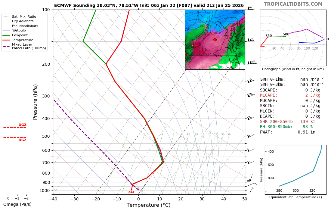
I think it's having issues with snow vs sleet/zr as well? Look at this 6z sounding over DC @ 18z Sun.. maps say zr. That looks like snow to me unless there's a sneaky warm layer in there
-
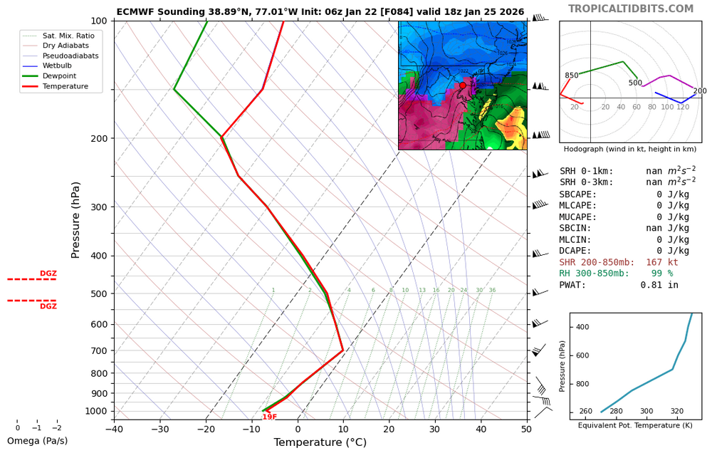
This is 6z but same thing going on. I'm having a hard time believing this sounding results in ZR

-
January was a nice reminder we still can get sustained winter conditions around here but overall boring weather year IMO. As other have said late summer was a nice treat. Not quite 2014 level but close. The last 90+ degree day at CHO this year was Aug 17!
-
CHO might hit 70 lol 66/37 at noon
-
Well I'm not going to complain about 65F under full sun. Looking forward to winter's return but this is nice... I've got windows open.
-
ok? Screenshot of a singlular clickbait youtube channel. What does this prove? There's plenty of non-garbage to find out there as well. The stuff that shows up on your home page reflects what you sit and watch most often more than anything else...
-
This storm is on the 26th
-
A tradition unlike any other!
-
12/5 - 3.1" 12/8 - 2.8" Total: 5.9" What a start to the season for the southern crew
-
Steady light snow again in Charlottesville the past ~45 mins, bordering on moderate now. Best looking flakes we've had all day imo. DP popped back up to 21 after bottoming out at 14 around 4:30. 25/21
-

-
Dry air is crushing us now in Albemarle. Pixie dust at this point. DP has dropped from 21 to 16 in the last 90 minutes. 3kNAM says we're about done. HRRR hints at another burst of precip in the next hour or so
-
Yeah I think that's exactly what's happening, also related to why this storm came further north than it was supposed to a few days ago. The HP seems to have been slower getting into place than originally modeled. You can see the dry air eating away the returns on the northern side as it's pushing South. The 3k NAM has precip eroding all the way back to 64 at one point this afternoon before the coastal takes over, but I'm choosing to ride the HRRR lol
-
12/5 - 3.1"
-
Close to 3" on the south side of Charlottesville. Light snow hanging on for a bit longer 27/24
-
a full cancel/grief/uncancel cycle before Thanksgiving. Yall have been practicing! This place is in late season form!
-
I'd imagine it's simply random chance of where the heaviest bands set up coming off the lakes. Some areas had much higher rates than others. @SnowenOutTherewas hiking some ridges in WV yesterday and reported he saw 1-2in in one spot and 3-4in 10 miles away at another
-
27/7 for the low at CHO
-
Great video from Phillip Prince on the destruction seen around where the eyewall came on shore. This focuses mostly on the geography/geology angle and how that affected things but I figured many in here would find it interesting.
-
Maybe you should read his posts a little closer before spitting out knee-jerk reactions? It's either that or you are really bad at geography. Calling WV a "western" state that has "nothing to do with the area" is a complete head-scratcher. Harper's Ferry is 40 miles from the DC line
-
The irony of a PA poster saying this in the MA forum lol.. come on
-
Still under 80 at CHO. The filtered sun is really holding temps down
-
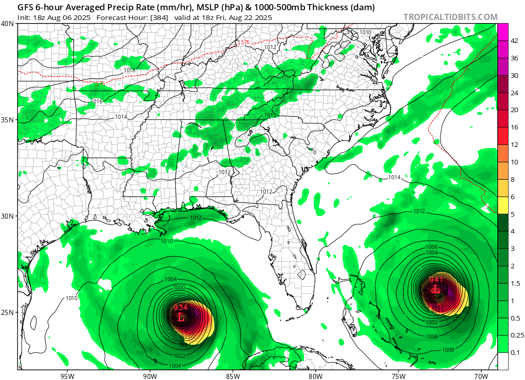
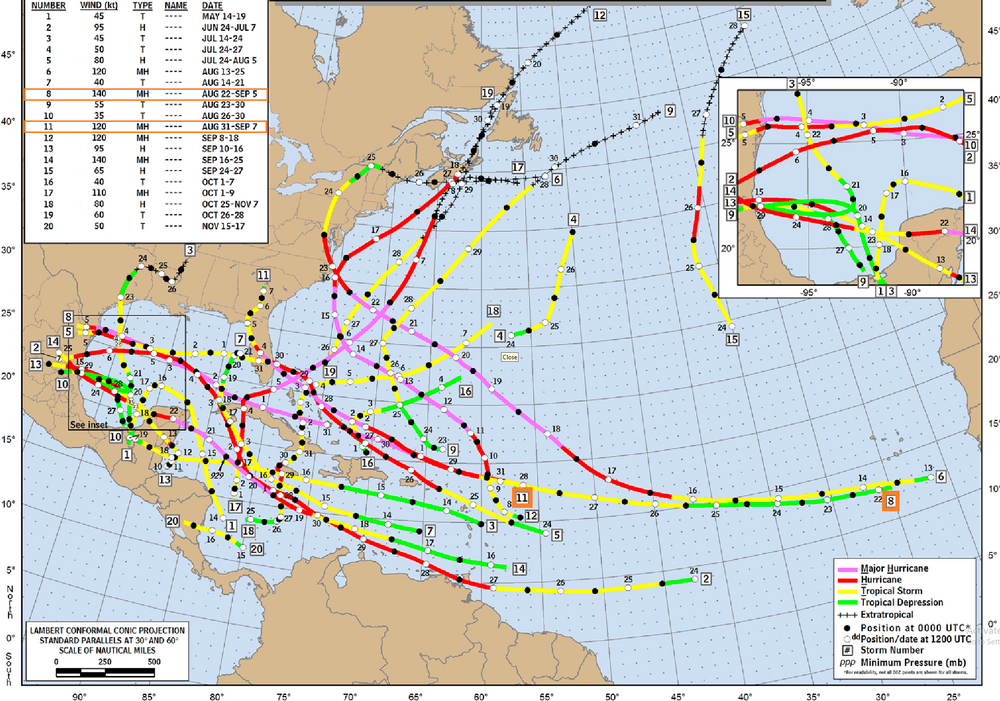
Studying the paths of those two is pretty interesting. TC #11 formed directly in the wake of the other MH in that pair (#8) with only two days of separation. Worth mentioning that TC 9 and 12 also formed in the same general part of the Atlantic within that roughly 2 week period at the end of August. There must have been some seriously favorable conditions.
-
From yesterday. I know it's hr 384 but it got my brain going. Is there any historical precedent for what's shown, two sub 950mb canes approaching the SE simultaneously?

-
There's a reason farmers would get up at 5am to start their day. Working in the mid-day summer sun was avoided if possible southern europe has/had similar behaviors. Siestas/riposos were a midday break to shut down your business, go home, and/or rest. Typically in the early afternoon