Chinook
-
Posts
10,673 -
Joined
-
Last visited
Content Type
Profiles
Blogs
Forums
American Weather
Media Demo
Store
Gallery
Everything posted by Chinook
-
This seems intriguing. Perhaps 10/9 might be an interesting day to see what the ensemble averages have for 10/19
-
mini-rainy season
-
For my area, it was mainly 4.0 degrees F above average, to possibly 5 degrees above average according to this chart. I believe it was the 2nd warmest September for Fort Collins, and 3rd warmest for Denver. In my opinion, it's an extension of the drought in the north and west this summer. Also, the ridge in the West seems to be a teleconnection with the average trough in the Gulf of Alaska in September.
-
This is the new thread for discussing events in the Mountain West. Looks like ABQ got 0.40" of rain last night, plus more for the Sandia mountains.
-
Several areas got about 0.05" of today with a non-thunder rain shower moving across the area. It's not much. The temperature was cooler in to the upper 50's just after the rain. This might be one of the last times to be able to use the NCEP web site for the GEFS ensemble plumes, but they still should be on "weather dot us" web site if you are interested in rainfall/snowfall amounts for this winter. Talking about winter, I will start the Mountain West winter thread on Oct. 1st, just perhaps to avoid confusion. It's obviously not too wintry.
-
Sheridan was almost 40 degrees warmer than Gallup. Temperatures were up to 96 in North Dakota.
-
Some rain and thunderstorms will affect the southwestern US on Monday through Thursday. For northern Colorado, there should be a chance for rain on Wednesday with a cold front. There is a chance that another upper low could bring heavy rain to New Mexico and Texas after that. The GEFS averages say that Denver will be above average for almost every 5-day period out to 15 days.
-
sunset
-
Updated dashboard on College of Dupage weather web site. Looks like they could have Canadian GEM-GDPS at some time in the future.
-
measured rainfall near Toledo 9/20-9/21: trace to 0.08" (0.01 at KTOL) 9/21-9/22 (as of 12z) about 1" to 3.94" (2.78" at KTOL) 9/22-9/23 (as of 0056z) 1.08" at KTOL KTOL total: 3.87 this is a very high 3-day rainfall total for any one spot in NW Ohio
-
sep 1: light rain (trace) sep 1-2: low visibility again sep 3: morning rain shower 0.01 to 0.12" evening thunderstorm. constant thunder in clouds, total: 0.34" sep 9: high temp of 95-97 (record) sep 10: high temp of 95-98 (record) sep 11: high temp of 96 at fort collins (record) sep 13-14: nighttime thunderstorms of 0.03" with 0.10"-0.48" in Fort Collins and 0.08" in Loveland sep 16: high temp of 90-93 sep 17: high temp of 71 sep 18-19: high temps in the 80's sep 20: sprinkles overnight (trace), high temp of 66-70, clear sky, light snow on mountains, north wind of 20 mph
-
Larimer County got some unexpected thunderstorms last night, with around 0.10" to 0.48" for Fort Collins
-
3 Records in a row for Fort Collins A couple of rain showers came in today. There was brief thunder, and the pavement got wet, but not for too long. The view of the mountains is now much more clear.
-
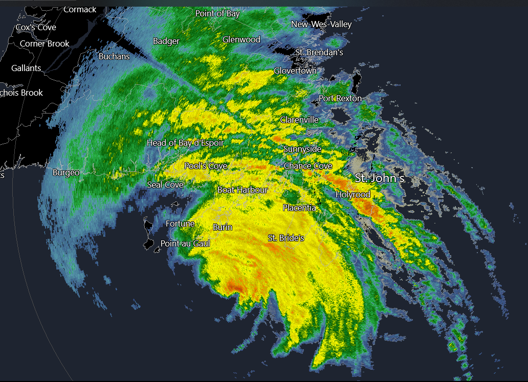
St. John's observation, wind gusts of 78 knots or 89.7mph METAR: CYYT 110424Z 18044G78KT 2SM R16/5000VP6000FT/D RA BR OVC003 19/19 RMK SF8 PRESFR DENSITY ALT 2200FT
-
We've had 7 straight days of some forest fire smoke, and yesterday Fort Collins broke a record at 96 degrees. Today: I believe Fort Collins broke a record with 98 degrees. Denver was 96, and then 99 today.
-
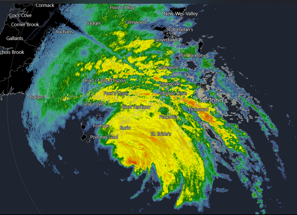
Cape Race observation: 41 knots gusting to 58 knots METAR: CWRA 110300Z AUTO 16041G58KT 19/19 RMK AO1 5PAST HR M PK WND 15058/0253 P0014 T01940191 50057
-
radar from 10:05 PM Eastern
-
 Super Typhoon Chanthu, a 135-kt storm headed in ... a totally random direction? The HWRF and official JTWC forecasts have this staying a little southwest of Taiwan, perhaps sparing southwestern Taiwan of the 50-kt winds. That still could be wrong though.
 -
This is a picture from the same hike, on Sep 4th. The forest fire smoke has completely obscured Long's Peak. (Compare to picture posted on Aug 29th)
-
My place got some very light rain on Wednesday night. Then I got a rain shower at 7:30-8:00 this morning and 6:30-7:00PM. For our afternoon storm we had a quick 0.25" or better with constant thunder in the cloud, but I didn't really see any lightning bolts. Then we had some orange clouds at sunset.
-
from NWS-WPC storm summaries. web page: https://www.wpc.ncep.noaa.gov/discussions/nfdscc4.html
-
August will have a mean temp of 72.0 or slightly higher for Fort Collins. Note: 1981-2010 climatology is 70.2F, but 1991-2010 climatology is notably higher at 70.7F. Today is another 91 degrees, at least, and the crud is back, with visibility only 5 miles. I tend to think of it like this: at least our area did not have the very high temps of the northern Plains and Pacific Northwest this summer. Also, our area is not listed as being in drought, except for Washington County, CO.
-
There was a wind observation at Bayou Gauche had a wind gust of 93mph about a half hour ago. Site: BYGL1, listed as a buoy, but apparently on land.
-
amongst all the talk of the hurricane, perhaps I will post these pictures of a pleasant foothills hike I did yesterday. Some of the recent days have been much lower on smoke/haze (but not today)
-
This buoy measured 933.6 mb