Chinook
-
Posts
10,673 -
Joined
-
Last visited
Content Type
Profiles
Blogs
Forums
American Weather
Media Demo
Store
Gallery
Everything posted by Chinook
-
Every single model has this being a weak storm for Sheridan. So, sorry.
-
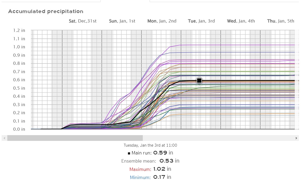
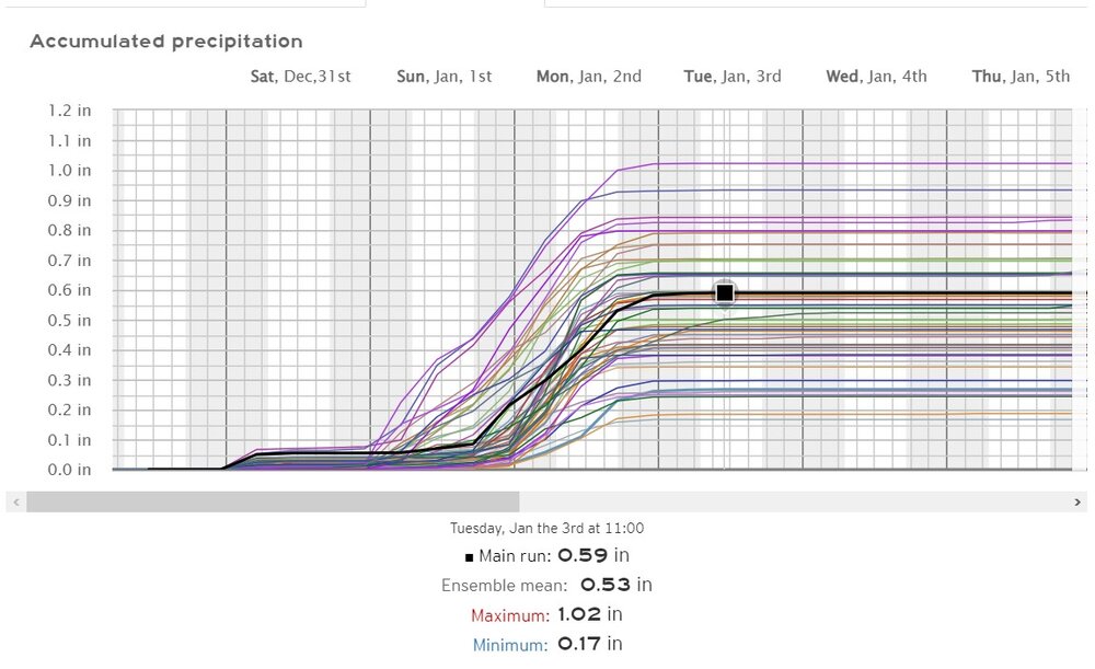
Lets' go for weenie mode here: The EPS ensemble members max QPF is 0.66" or for Denver, and 1.02" for Fort Collins. These are much higher QPF values than the 12z or 18z GFS. The overall synoptic forecast of the storm has still some questions to be answered for northern Colorado.
-
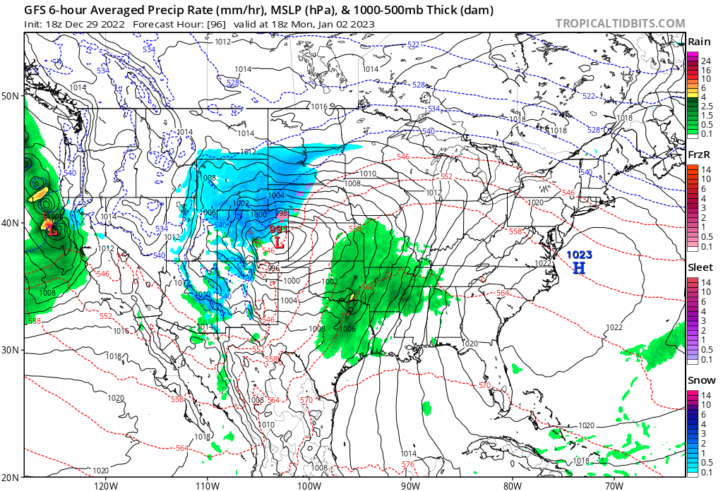
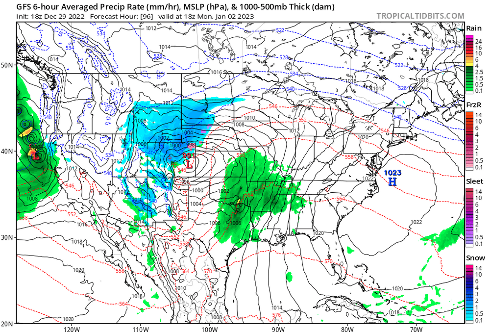
Models from 12z and 18z today have significant snowfall for CO, WY, and NE on January 2nd with a 500mb low developing over Denver.
-
The western snowpack has been impressive in far west areas. Right now, the Sierra Nevada and Nevada's great basin have the highest percentages. New Mexico isn't getting on the fun.
-
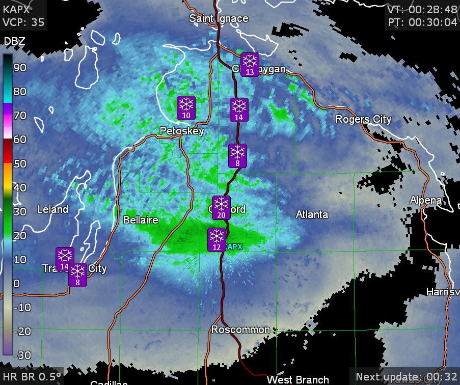
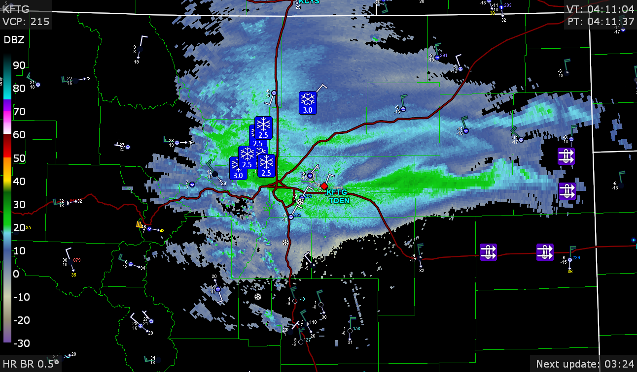
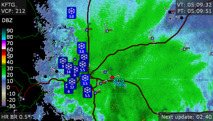
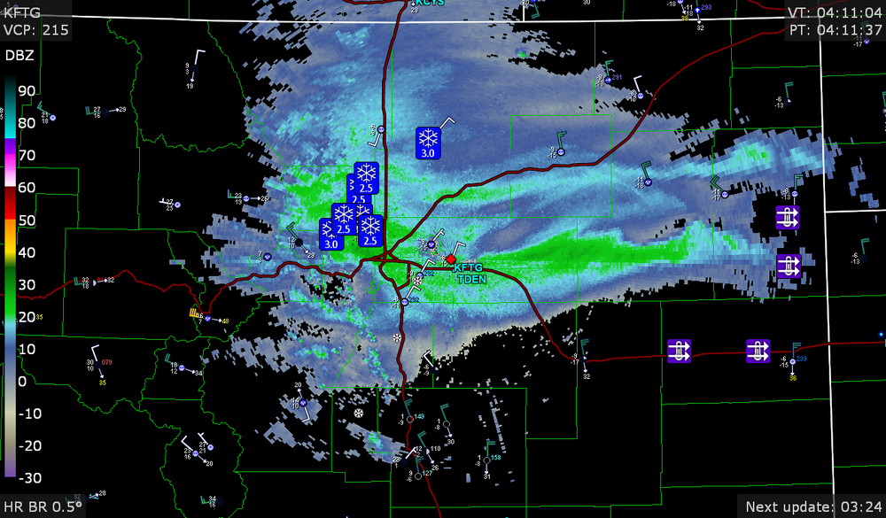
The spotter reports have been 3.0" to 5.5" for many city areas, and higher for Jefferson County. There is a pretty heavy area of snow at Castle Rock, and it seems to be showing the rotation at maybe 700mb if you watch a short radar loop.
-
My loops of the previous storm GFS Surface forecast loop NWS Surface Analysis 500mb vorticity 850mb vorticity 700mb temperature 850mb temperature 500mb temperature National/Regional Radar Composite GFS Relative Humidity (mean layer) 250mb wind speed
-
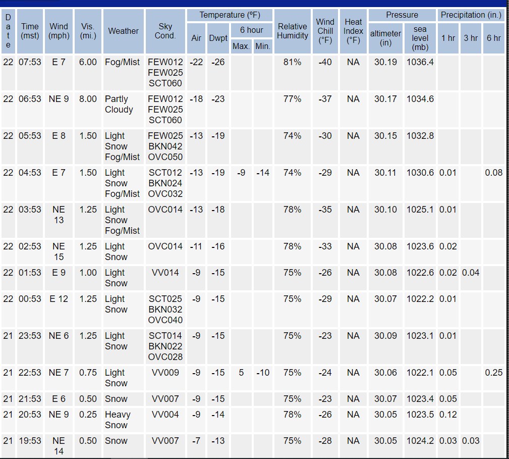
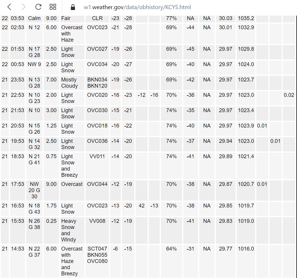
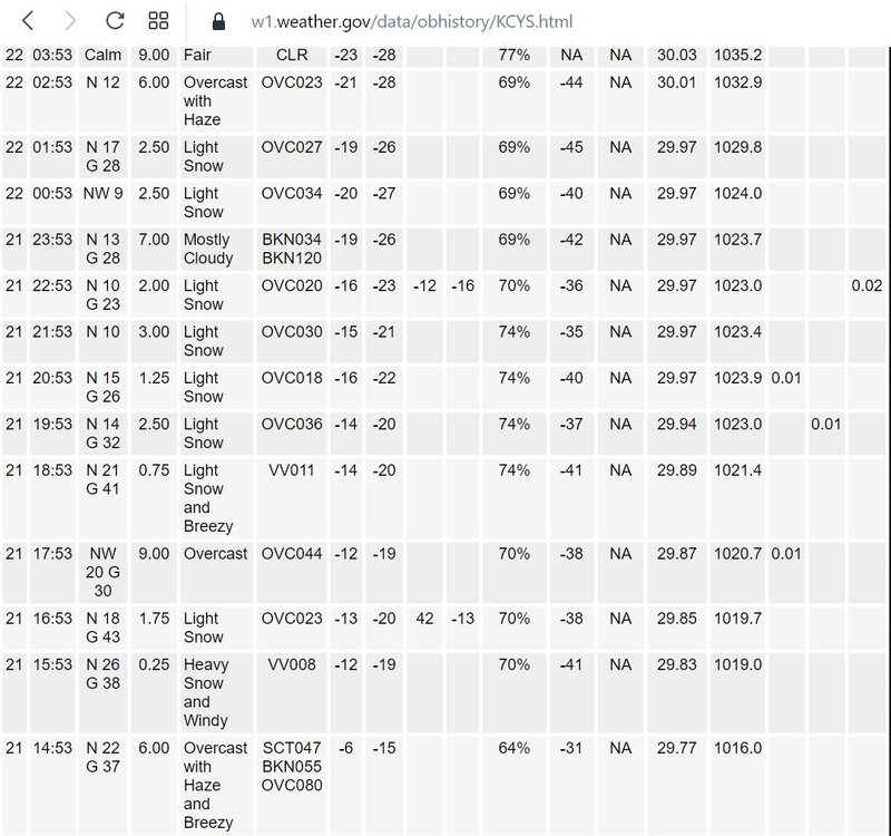
The lowest wind chills on December 22nd were basically -34F in the city of Denver. As I said before, in the 16 years that I lived there, Denver International Airport never was -22 (air temperature).
-
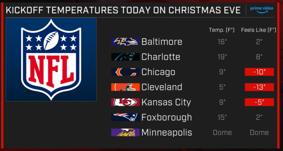
Wind chills for the NFL. The Titans game has been delayed until 2:00 because there are rolling power blackouts due to the cold
-

Pre-Christmas (Dec 21-23rd) Winter Storm Part 2
Chinook replied to Chicago Storm's topic in Lakes/Ohio Valley
This tweet has, in fact incorrect information on which road it is: it is I-80 -
Pre-Christmas (Dec 21-23rd) Winter Storm Part 2
Chinook replied to Chicago Storm's topic in Lakes/Ohio Valley
NW Ohio essentially maxed out at a 46-48 degree F temperature drop in 24 hours. Toledo went from 42 degrees to -3 degrees in 12 hours, the most impressive drop I may have ever seen for Toledo.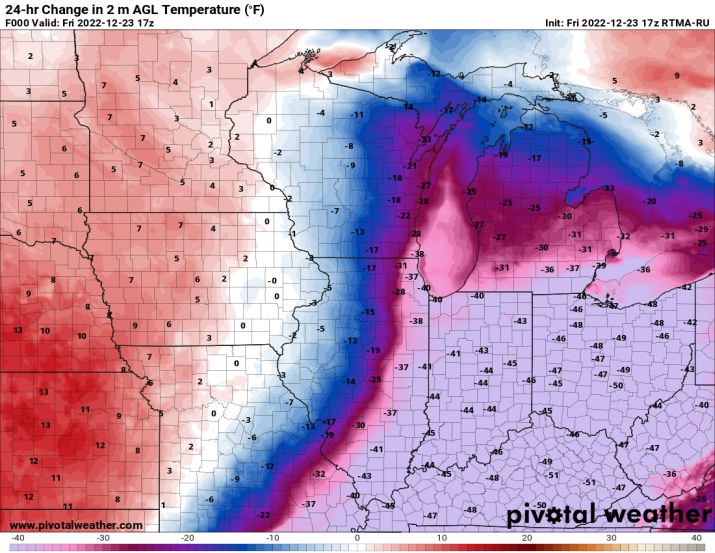
-
Pre-Christmas (Dec 21-23rd) Winter Storm Part 2
Chinook replied to Chicago Storm's topic in Lakes/Ohio Valley
72 hr multi-input snowfall analysis ending at 00z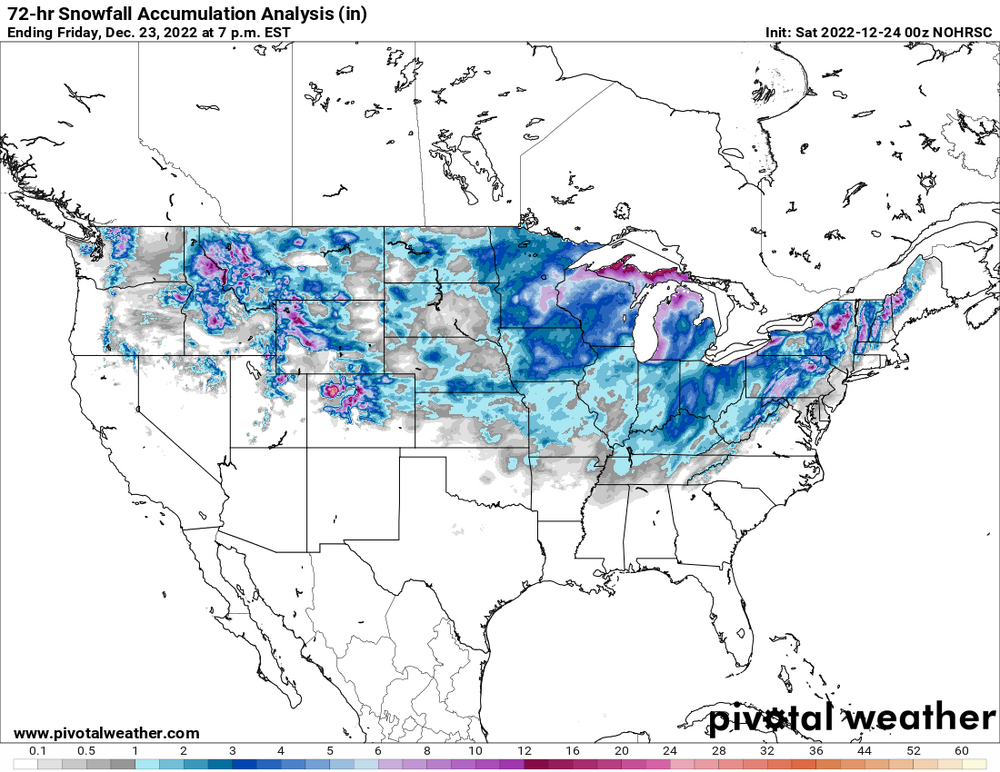
-
Pre-Christmas (Dec 21-23rd) Winter Storm Part 2
Chinook replied to Chicago Storm's topic in Lakes/Ohio Valley
My place in the Toledo area got about 1" with some drifts. The drifts aren't really impressive. In the city, the visibility is fine, as the ground blizzard must be worse in more rural or open road setting. I can sort of feel the 50mph gusts against the house. Toledo Express Airport had ground blizzard conditions, as the reports said heavy snow but it certainly hasn't been heavy falling snow. Wind chill is negative a lot if you consider 46mph-47mph wind gusts at this time, but the actual calculation is based off the steady wind speed, so the wind chill was -29 early today. So it's a unique situation with disappointing snow amounts. And rain kind of froze onto stuff. About 10 years ago, I drove through a ground blizzard in Nebraska when the snow wasn't sticking to the road, so I had good traction. I wouldn't have tried it if I didn't have good traction. -
Pre-Christmas (Dec 21-23rd) Winter Storm Part 2
Chinook replied to Chicago Storm's topic in Lakes/Ohio Valley
Recent snow spotter reports have been 8" to 25" for N MI. Surprisingly it is warmer and less windy than the lower Great Lakes while this is happening, but still cold and windy. also note: news story today from NW Ohio
-
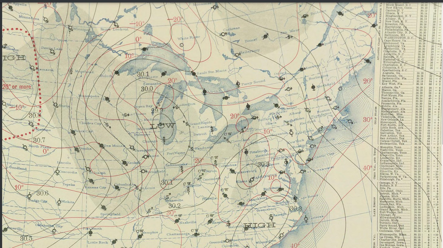
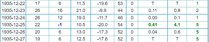
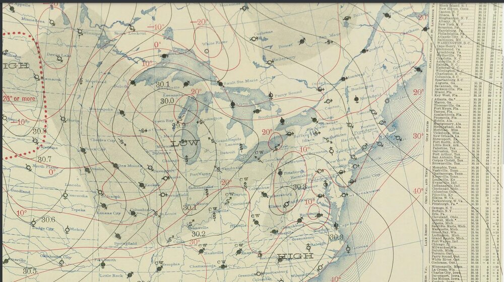
This situation is a little like Christmas 1935. A cold front with high winds, snow, and a temperature drop to zero happened in the lower Great Lakes Toledo's temperature and snowfall 1935 surface map
a.jpg.5834d653556a208ab79888cb12b33354.jpg)
-
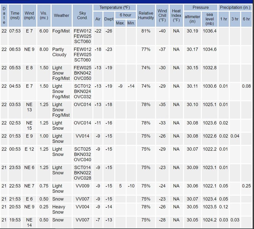
So this is happening. Cheyenne had whiteout conditions while -12 degrees, wind gusts to 38 knots, blizzard. Cheyenne was recently -25 with wind chill of -51. Denver had snow, now its -22 with wind chill of -40. That never happened when I was there.
-
some snow accumulations with a frigid -6 to -9
-
Pre-Christmas (Dec 21-23rd) Winter Storm
Chinook replied to Chicago Storm's topic in Lakes/Ohio Valley
A little off topic here: I may be able to access several resources regarding winter storms in that time period (I saved a lot of images, plus there are other resources online.) Not sure what you were thinking of Meanwhile... GFS Ensemble member 19 has 2.5" water equivalent for Chicago, so I'm rooting for that. the ECMWF ensemble members max out at 1.64" total water equivalent for Chicago. -
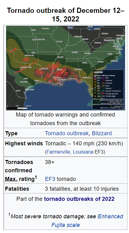
My loop of the past 6 days. I made this because so much happened: the northern blizzard, tornadoes, and the northeast winter storm http://www.greatlakes.salsite.com/Dec_12_18_2022_GFS_surface_loop1.html
-
Pre-Christmas (Dec 21-23rd) Winter Storm
Chinook replied to Chicago Storm's topic in Lakes/Ohio Valley
It has been a long time since I've seen a model battle like what we are seeing today. The Midwest weather almost never has model runs debating 980mb and such. There's the 12z ECMWF's 979mb in Muskegon, Michigan versus the 18z GFS run of 980mb-976mb in northern Ohio. These days, I'm back here and not in the West, so I'm in the middle of it. There's going to be a lot of model runs with widely varying scenarios in the next few days. I'm going to just keep watching the total weather weenieism on this board and enjoy it! Because hey, the 18z GFS has 13.8" for Toledo. And I'm sure the models today won't be right. And I'm sure snow-rain ratios won't be more than 12:1 for my area whatever does happen. -
Pre-Christmas (Dec 21-23rd) Winter Storm
Chinook replied to Chicago Storm's topic in Lakes/Ohio Valley
I vote for Ensemble 14 -
Pictures: newest Wikipedia info. Graphic that was tweeted by Jim Cantore.

-
Here are some maps regarding the Mid-Atlantic storm. The vertical-horizontal cross section (4th picture) shows the warm layer at 850mb extending well into the middle part of the image, with below freezing underneath 850mb. That's where the sleet/freezing rain should exist. I used the RH as colors, as to make it less confusing. Green colors are values of high relative humidity. On the 5th picture you can see temperatures above 0C at 850mb in the same places as those of temps below 30F surface temperature.
-
It looks like the debris signature for this has tracked from south of Newton MS to almost Hickory MS
-
north Texas
-
I'm just watching Reed Timmer's live stream which started less than 2 hours ago (not sure exactly when it started). He says there has been a Decatur TX, south of town, and also around Weatherford.