ROOSTA
-
Posts
3,144 -
Joined
-
Last visited
Content Type
Profiles
Blogs
Forums
American Weather
Media Demo
Store
Gallery
Everything posted by ROOSTA
-

Thursday, July 27, 2023 Severe Weather Potential
ROOSTA replied to weatherwiz's topic in New England
Don't forget to have lightning detection software running in a back round window. BLITZORTUNG.ORG I find it highly accurate. Side-by-side with GRLevel2. That's all you need! Well, a storm might help. LOL -
Thursday, July 27, 2023 Severe Weather Potential
ROOSTA replied to weatherwiz's topic in New England
Some localized area's are going to get blasted. Most will be disappointed, fickle nature of the beast. No marine influence less immediate S Coast. Good Luck! -
Speaking of humidity, down here the Td will not drop below 70F till September or October. This past week has had Td's around 80F, combine that with temps 90-95F, Heat Index 105-110F. Even now T92 Td 80 it's brutal but get used to it.
-
May obs/discussion thread - Welcome to Severe Season!!
ROOSTA replied to weatherwiz's topic in New England
A WILD AFTERNOON INBOUND. I'm talking Severe. Yesterday was a primer - just 5 miles to my S had baseball size HAIL. Freezing levels are around 15-20k ft. Towers are starting to go up, any cells that build over 30k are capable (strong updraft) of going severe! LEGIT SEVERE! Vehicles in the carport! These can be scary; you don't want to be in one. Watch pending. The AFD mentions to be watchful that's a first. -
The last eclipse I traveled to SC, one of the most spectacular sights in my lifetime. The one in '24 I'll be traveling to Little Rock, AK., or the surrounding area (weather dependent) for about double the duration of totality of the previous 2min compared to about 4.
-
Pretty cool watching the Masters. Like playing a Spring round in New England and getting back-door-ed! Tomorrow-- forget-about-it. What a wedge! very pronounced on radar. On the bucket list to go one of these years. Tickets are $$$ and drawn by lottery. Talk about planning ahead. GEEZ
-
Look at it this way, it's to early. Always next time!
-
Hard to achieve Severe criteria even under the best condition. Seems like every time the dynamics come to together things go to sh*t. A little thing call the Atlantic Ocean. During "rainy" season I get daily gully-washers 2-3"/hr, prolific lightning with 40-50mph. down bursts none of which are warned.
-
Never really get into the good dynamics. Mostly tapped further S. A good reason for SPC's MD. A squall line with straight-line winds. Should "bow" out in places as it traverses SNE.
-
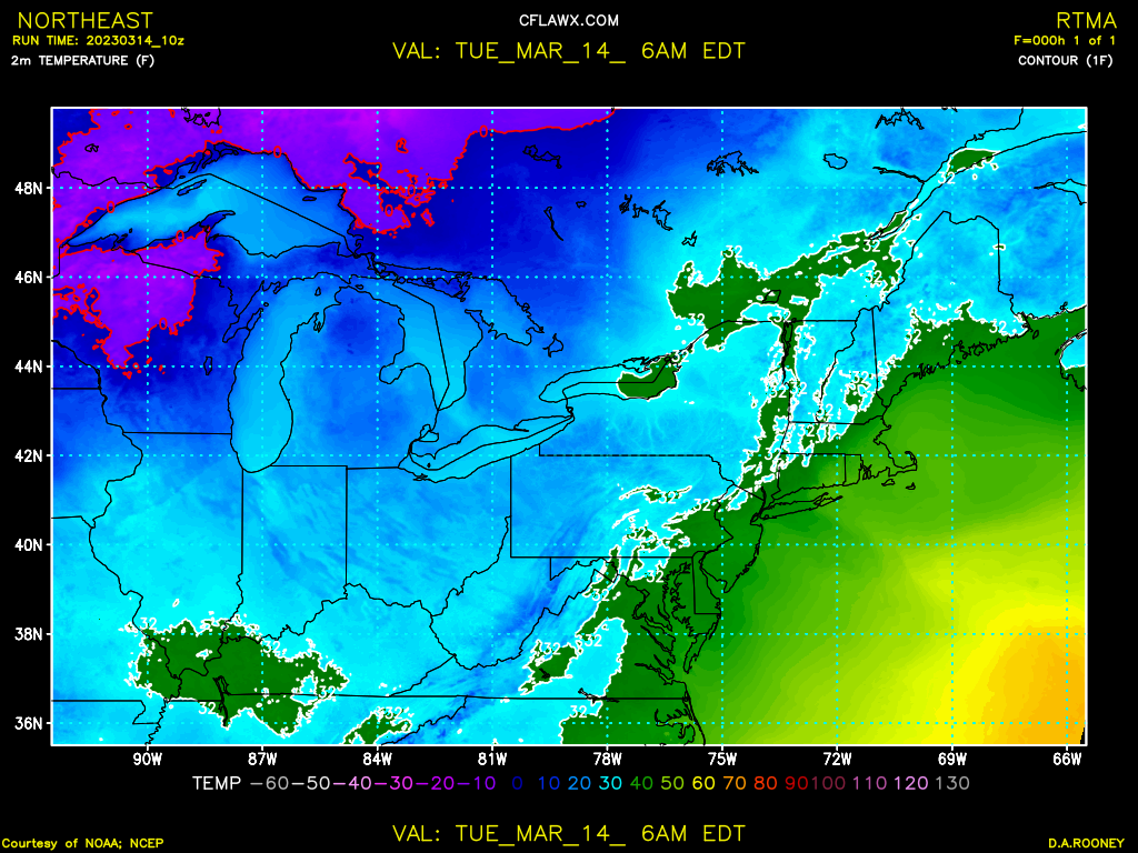
SFC to 1K shear increasing. CAPE is marginal but with the VORT coming through. WIND with a few cells maybe close to severe. Looks like straight-line 8-12 W-E passage. Already Summer here T 92F with a Td 66F. Bone dry here, everything turning brown.
-
Is it true that NOW WINTER decides to flex some muscle? Can't buy what the 12z GFS is selling yet, need a few runs with it still there. No matter I'll take my 90F with dews and enjoy watching from afar.
-
Congrats More than I got!
-
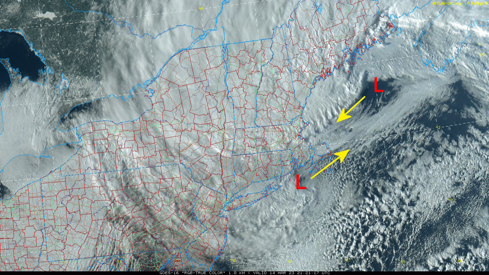
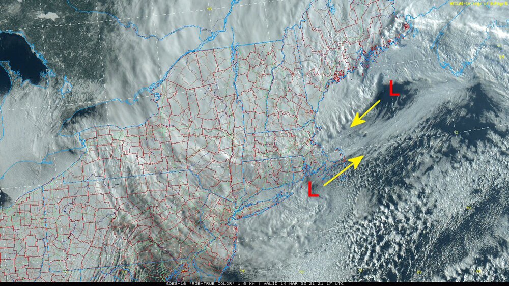
Still a dual LOW. I don't think there's a storm to compare. I put the arrows on showing the direction to which they're moving. Surreal loop! S
-
From a meteorological standpoint for a spring snow event this has just about everything. Fascinating watching this and it continues to unfold. Surprise, surprise!
-
Amazing the growth of PWS. Weather Underground has hundreds in Ma., unfortunately there doesn't seem to be any QC. Wish there were a way to filter.
-
Maybe a consolidation, occludes then drifts E. Net result a blossoming in returns, seems plausible.
-
The HRRR (who's to say it's right or wrong) insistent on retrograding. If it's even 1/2 correct, well that would indicate this is far from over. ------------ *Edit* The ctr does seem to be backing in.
-
Springs hope eternal. For those getting screwed- the next one is in striking distance.
-
Primary Center seems to be tracking farther E then models depicted. The secondary xtension can still be observed in the Satellite presentation. Suspect that is slowing change-over and not consolidating banding. Every storm like a fingerprint: No two are exactly the same.
-
I remember a Storm Feb. early 2010's rates dropped D/S I think and all that it did was drizzle a few flakes mixed, modelled to fill-in and dump, well it never did. Talk about an implosion on the board. Very reminiscent, this storm has more potentail and still time!
-
VIS SAT A thing of beauty. You know the models did have a hard time latching on. What's going down is pretty much what was being runout. Adjustments being made in what you see is what you get. North Shore of Ma. (might, could) still pull double digits. I'd be happpy just to see a flake. Nah, I can go to Walmart for that. 2' OR BUST.
-
If the models are to be believed the Ocean LOW should start to retrograde reaching it's most eastern track. Phase almost complete, dry-slot should fill-in with a firehouse commencing aimed into NE Ma.
-
Finally the whole R/S line is collapsing across all of SNE. Occasional fatties should be mixing in across all area's!!!!!!!! Rejoice.
-
I don't know if these maps I post help. They be an hour behind but they do point out what's going on at the SFC. Ocean influenced E winds into ME. Can see the dual LOW.

-
Storm is at @ 993Mb and modelled down to 970 something. Still a ways to go! WOW