Jed33
-
Posts
1,143 -
Joined
-
Last visited
Content Type
Profiles
Blogs
Forums
American Weather
Media Demo
Store
Gallery
Everything posted by Jed33
-
Jan 30th-February 1st 2026 Arctic Blast/ULL Snow OBS Thread.
Jed33 replied to John1122's topic in Tennessee Valley
It’s been so long since I’ve seen a ULL I forget entirely, but seems like the give this kind of presentation on radar. Just kind of spinning around? Idk I may be grasping for straws here, but yes it’s odd for sure. -
Jan 30th-February 1st 2026 Arctic Blast/ULL Snow OBS Thread.
Jed33 replied to John1122's topic in Tennessee Valley
Just measured 2.5 it’s coming down now. I’m gonna try to sleep yeah right, we all know how that’s gonna turn out! -
Jan 30th-February 1st 2026 Arctic Blast/ULL Snow OBS Thread.
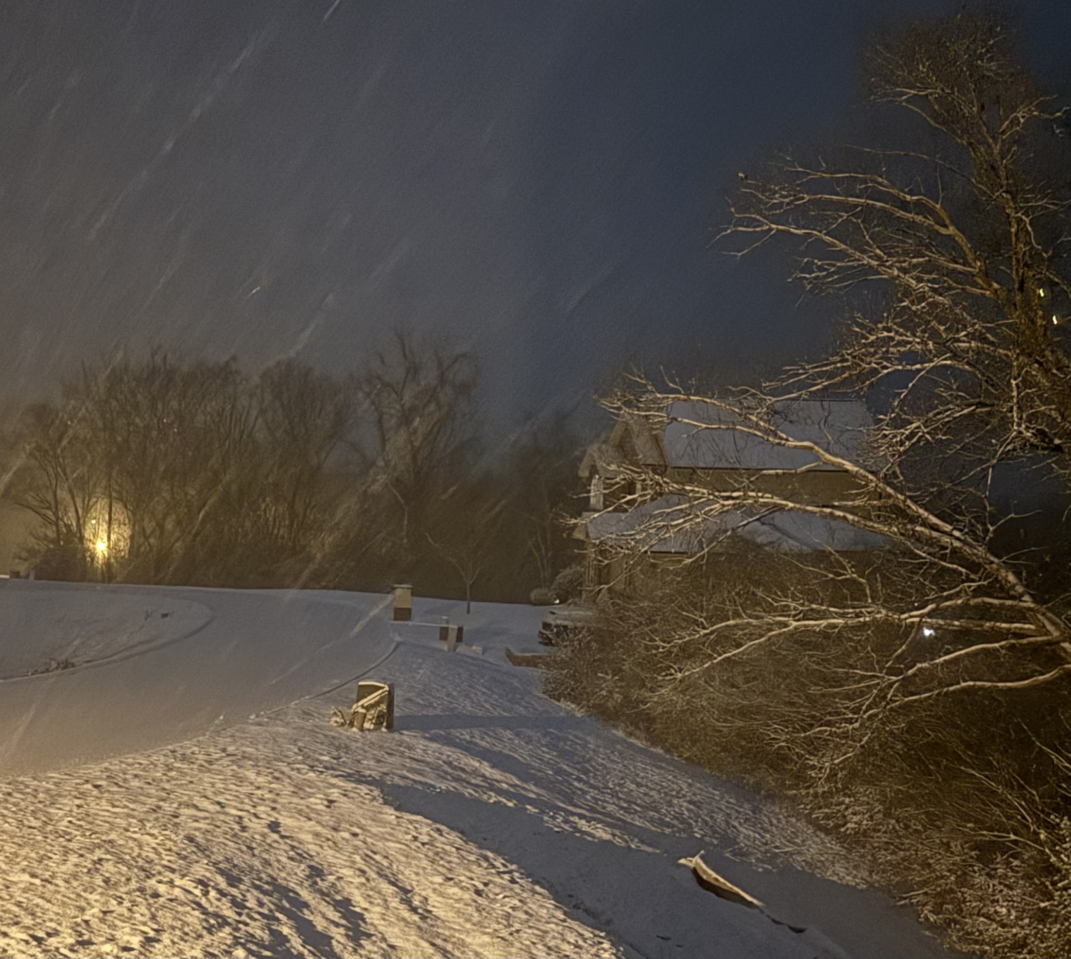
Jed33 replied to John1122's topic in Tennessee Valley
Current view from upstairs looking out over the winter wonderland.
-
Jan 30th-February 1st 2026 Arctic Blast/ULL Snow OBS Thread.
Jed33 replied to John1122's topic in Tennessee Valley
Really coming down now. Closing in on 2in! Temp 23 -
Jan 30th-February 1st 2026 Arctic Blast/ULL Snow OBS Thread.
Jed33 replied to John1122's topic in Tennessee Valley
Have close to 1.5in now. Still snowing. Temp is down to 25 dewpoint 24. The front must have moved through here about 30min ago bc the wind has increased substantially and the temp drop from 27 to 25 in that 30 min. -
Got between 1/2-3/4in now in grass and on trees the edges of the road are beginning to cave but we’re heavily salted earlier so the road may not fully get covered for awhile.
- 782 replies
-
- 1
-

-
- extreme cold
- snow
- (and 1 more)
-
Jan 30th-February 1st 2026 Arctic Blast/ULL Snow OBS Thread.
Jed33 replied to John1122's topic in Tennessee Valley
That’s a really nice area down there! I used to live in Shelbyville. Thanks for the update! -
Jan 30th-February 1st 2026 Arctic Blast/ULL Snow OBS Thread.
Jed33 replied to John1122's topic in Tennessee Valley
Well boys and girls at least the sun went to bed now! -
Jan 30th-February 1st 2026 Arctic Blast/ULL Snow OBS Thread.
Jed33 replied to John1122's topic in Tennessee Valley
Getting white around here now probably 1/4-1/3in on trees and grass. The temp has dropped to 28. -
Jan 30th-February 1st 2026 Arctic Blast/ULL Snow OBS Thread.
Jed33 replied to John1122's topic in Tennessee Valley
Seeing more steady light snow here too. -
Jan 30th-February 1st 2026 Arctic Blast/ULL Snow OBS Thread.
Jed33 replied to John1122's topic in Tennessee Valley
Few flurries flying right now here in Morristown. -
I saw a halo around the moon earlier and thought the same thing.
- 782 replies
-
- 2
-
-
- extreme cold
- snow
- (and 1 more)
-
The Canadian looks very similar to the Rgem. Pretty much right on top of each other.
- 782 replies
-
- 1
-
-
- extreme cold
- snow
- (and 1 more)
-
Looks like a batch of moisture is moving in now. Although I don’t know if it’s reaching the ground. Sure is showing up on radar though.
-
The 18z rgem was something else! Too bad it doesn’t go beyond 84hrs!
-
Really coming down in town here now. Looks like some small bands are forming over the area.
- 618 replies
-
- 5
-
-
- observations
- obs thread
- (and 1 more)
-
Light snow overnight and a decent dusting on everything this morning including the roads. Temp is 17.
- 618 replies
-
- 1
-
-
- observations
- obs thread
- (and 1 more)
-
My sister lives in Oxford. She says the same thing. No power, trees falling everywhere. Not a good situation but she does have heat and the essentials. It could be a long road of recovery in that area though.
- 618 replies
-
- 1
-

-
- observations
- obs thread
- (and 1 more)
-
The temperature gradient from Pigeon Forge to Gattlinburg and Wears Valley is crazy! Just a few miles and 25 degrees difference!!!
-
Historic Tennessee Valley Cold, Snow, and Ice Events
Jed33 replied to Carvers Gap's topic in Tennessee Valley
I saw this on FB this morning and thought I’d post it here. This article is about Morristown in general, but it sounds like it was quite the snowstorm for E TN. I didn’t live here then, but I know that was some kind of winter for sure, even in N MS where I was at the time.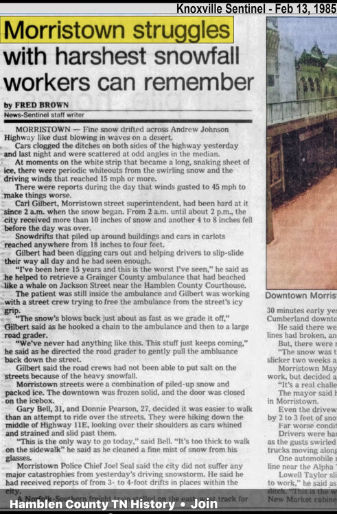
-
Mostly freezing rain here now too. Cars glazed over and walkway is crunchy under the sleet. The snow is fast compacting. Temp is 27 dewpoint 26.
- 618 replies
-
- 2
-
-
- observations
- obs thread
- (and 1 more)
-
It’s changed to sleet here too but picked up about 1/2in on the grass and dirt before it switched to sleet.
- 618 replies
-
- 2
-
-
- observations
- obs thread
- (and 1 more)
-
It is absolutely dumping turkey feathers here right now no mix at all but just pouring snow! Huge flakes!!
- 618 replies
-
- 3
-
-
- observations
- obs thread
- (and 1 more)
-
Coming down at a good clip now moderate I’d say with mostly dime sized flakes
- 618 replies
-
- 1
-
-
- observations
- obs thread
- (and 1 more)
-
Light snow here too with some bigger flakes here and there