Jed33
-
Posts
1,144 -
Joined
-
Last visited
Content Type
Profiles
Blogs
Forums
American Weather
Media Demo
Store
Gallery
Everything posted by Jed33
-
December 2025 Short/Medium Range Forecast Thread
Jed33 replied to John1122's topic in Tennessee Valley
I’ve noticed the rgem was teasing my area a lot the last few runs. The euro to some degree as well -
December 2025 Short/Medium Range Forecast Thread
Jed33 replied to John1122's topic in Tennessee Valley
Picked up a nice dusting here at the house overnight and actually saw more in town as I drove in to work this morning. Guessing there was maybe 1/2in or so at one point during the night here in town just judging by what’s left on rooftops and grass. -
December 2025 Short/Medium Range Forecast Thread
Jed33 replied to John1122's topic in Tennessee Valley
A heavy sleet band just plowed through I mean just smoked us! Only problem was it only lasted for about a minute or so. It was cool while it lasted. Tried to coat the walkway and grass. The temp fell from 40 to 38 during the time. That was unexpected, at least by me! -
37 here at my house on the border of Hawkins/Hamblen Co
-
Been seeing some flurries here as well this evening.
-
December 2025 Short/Medium Range Forecast Thread
Jed33 replied to John1122's topic in Tennessee Valley
Now seeing some sleet here as well. -
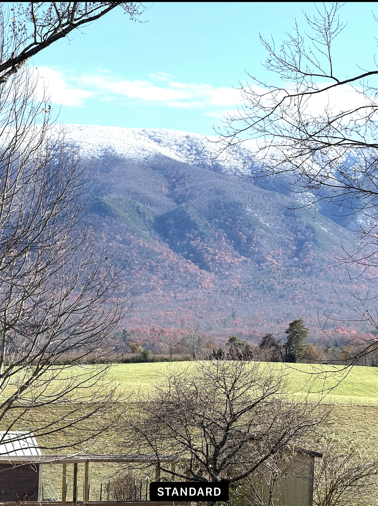
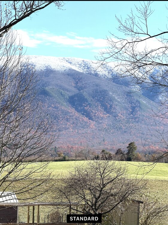
I was working in Camp Creek earlier today and took this picture around 2PM. It’s winter meets Fall! Still some color down low and color up top!
- 59 replies
-
- 10
-

-

-
In a very cautious but interesting twist, MRX just put nearly the whole CWA in an advisory. Updated the forecast discussion to mention that they feel the CAM models are correct with numerous snow showers developing between 11AM-3PM and that there is high confidence of heavier bands setting up which will reduce visibility and make travel difficult. They do say they do not have much confidence at all in where the bands will set up. Out of an abundance of caution feel it necessary to issue an advisory. Hmmm that doesn’t sound like the MRX of old haha! Good to see them acknowledge the potential!
-
Getting a nice snow shower here this morning. Woohoo! First of the season. Nice little dusting on the car, grass, and leaves.
-
I agree about Morristown/Dandridge. Including Jefferson City and Talbott where the NWS is located. I have a buddy near Panther Creek State Park who picked up 1.25in at his house. I only got .41 at my house though as the heavy rain fell apart as it moved NE. The same thing happened again today where the west side got heavy rain and barely any to show by the time it got here.
-
It’s been an incredibly wet week here as well. We had 3 rounds of storms today, the last one was like a wall of water! It was insane how hard it was raining! The wind blew so hard that it blew tons of leaves off trees everywhere, and even blew down some trees around here. Also, we had a couple minutes of small pea to dime sized hail. Unfortunately, I don’t have a great idea of exactly how much rain we got bc my weather station picked up a bunch of leaves from the trees across the street. My neighbor had over 4in of rain in his gauge but he said that was a combination of today and Tuesday. As some others have mentioned, at least here in E TN it has been very wet from the last part of July through August, and that is continuing. I’ll take it! After living through 2016 and some very dry years the last few years, I’ll agree, it’s nice to see it rain like this!
-
TYS is in Blount Co and like John said, it’s highly paved and concreted. It has its own mini heat island effect unfortunately. It definitely does not receive as much snow generally as surrounding areas.
-
Yesterday we picked up 4 rounds of heavy rain. Almost tropical like. Everytime it looked like it was going to let up, it would come right back again in buckets! We ended up with 2.48in for the day along with the cooler weather as well. So thankful for that! I did see where the rain ultimately won out last night in Bristol at the Braves v Reds game. Hopefully they get it in today.
-
Finally and I do mean finally picked up a great rain this morning. I had been missing out on most of the good rains for awhile as well. This morning though, a storm just blew up out of nowhere around 9 and it just dumped for about an hour. Picked up 2.1in total, most of that fell in about 30 min. It’s literally been close to a year since we had that kind of rain that fast at my house, and it’s not rained that much total in one day this year until now. We’ve had some 1inch or so days but not above 2 until now. Thankful for sure! I hope everyone else that has missed out gets some good rain soon!
-
I did not have a true dusting at my house, but did have a tiny amount on the cars and rooftops. There must have been a few heavier bands though because there were places around town here that did receive a solid dusting.
-
Switched over to snow here too now. A decent snow shower is currently passing through.
-
I wondered how it was up that way. My house is on the southern end of that band SW of Rogersville. It was absolutely ripping between 5-6 this morning. I was like a kid watching it myself. Fun times!
-
Wow! Woke up and the road is covered. Went out and measured 1/2in on it and my snowboard had 3/4in on it but looks like the wind has been blowing it some. From about 5-6 this morning it was ripping! Some other landscape timbers behind the house where the wind does not blow I measured close to 2in which includes yesterday (it did not hardly melt) and overnight bringing the total to right at 2in for the 2 days!
-
Yep I posted at just about the same time. Looks like it’s Central Valley north and east. Hopefully it back builds some more for even the southern valley.
-
Well, just when I thought it was going to stop and there was no hope of a band trying to reform, it’s snowing again and a small band is trying to reform, but unfortunately looks like it’s not going to last too long. Looks like it’s being aided by a stronger band trying to sink SE from KY.
-
Sitting at 1in on my snow board now. Just some very light snow falling at the moment.
-
Got between 1/2-3/4in now here
-
Woke up at 3:50 and nothing. Tried to go back to sleep and was in and out of sleep. I got up at 5:45 and it had just started. It’s kinda a fine flake snow, almost a fog but it’s coming down pretty good. Beginning to see the grass whiten up. Temp is 28 dp 28.
-
Same here! I thought the exact same thing looked just like Mammatus clouds.
-
I’m definitely not the most knowledgeable, but I look at them every morning around 7:30 on the CPC website. It definitely is encouraging to see them meander in phase 8 and 1 as well as 2. Most ultimately go into the circle today, but 1 or 2 including the JMA stay out of it and squarely in phase 1,2,and 3. The BOMM I feel like, at least this winter is always playing catch up to the ECMWF and GFS/GEFS. If you just look at Mjo plots, you’d think winter wants to hang around well into March this year! Would be great by me!