Jed33
-
Posts
1,143 -
Joined
-
Last visited
Content Type
Profiles
Blogs
Forums
American Weather
Media Demo
Store
Gallery
Everything posted by Jed33
-
Really none of the models did well at all with the snow here last night and today. The rgem, NAM, hrrr, globals, etc. this time they were horrible. Reading the comments from the NY forum, they were disappointed in the RGEM. It did pretty bad there too. It’s still a good model, but even good models have their weaknesses I guess. This storm was one of them.
-
Ended up with about 1/3in in grass and wood surfaces but the roads also caved a little this morning. Several school districts are out today. It’s still snowing pretty well in town right now as I type this.
-
Somehow this one band came back here! Man I’m shocked! I really don’t hardly ever do this well in NW flow but then again there’s hardly ever a Nor’easter of this magnitude to the NE helping pull down cold air and moisture from the Great Lakes like this. Approaching a quarter inch on the car and grass!
-
Just got under a heavy snow shower! The heaviest of today. It lasted about 10min and produced a nice dusting and would have been even more if it could have just held on a little longer. Temp down to 24 now after that.
-
Have had flurries and even a snow shower or two this afternoon. The temp really dropped after about 3:30. Currently 27.
-
Well I just woke up to a lightning bolt and rumble of thunder with this heavy line moving through! Activate TIMS and start the clock! I think this is one of the longest periods I’ve ever been through where there has not been thunder and lightning. I couldn’t tell you the last time we had it. Would have to have been late summer or early Fall. I know there are far less storms over here in E TN than middle or West TN-when I lived in Memphis and N MS we had thunderstorms year round almost every year. I’ve learned that is not the case here, but this has been long even for here!
-
It was unreal cars and trucks in people’s yards completely covered over by snow! The crazy thing was they tried to keep the resort open as long as they could by shutting down the top of the mountain and allowing mid and lower elevation skiing, but even that got shut down early and was closed the next day. Had to wait a couple days to be able to get back on the slopes. Fortunately for me it was Spring Break and I had the whole week! I did get a refund for the days they were shut down, so that was good! That was my first experience with thundersnow. It was literally snowing so hard on the lift rides up you would have over an inch of snow on your jackets or the seats by the time you would reach the dismount! They closed it shortly thereafter this and I have to believe it was probably close to 6in per hour rates. The ride on the lift was only around around 10min or so.
-
If that 10PM observation for tonight comes to pass, it would be so epic to be there!
-
I’ve never been to Mammoth, but have skied in extreme conditions in Montana and New Mexico. The heaviest snow I’ve ever seen was actually in Taos NM. 4 feet of snow in 2 days. The powder was surreal! They will likely get double that or even more at Mammoth this week! You seriously have to be extremely careful even more so after a snow of this magnitude once the snow ends. Like you said Carver, you can’t see anything and you don’t know what obstacles or tree wells, holes, etc you might encounter. Plus the resistance from the powder is difficult to navigate when it’s that deep. It’s fun to experience it but it’s hard to do anything much with it. It’s hard to imagine that there’s too much snow to ski on, but that is kinda what happens. Now give it a few days and it will be epic! However, with the forecast looking like a steady atmospheric river of snow, it might be more than a few days before they can reopen it!
-
There is a pretty extreme temperature gradient across East TN right now from north to south. It’s 64 in Chattanooga, 52 in Knoxville. It’s 42 at MRX, and 38 at my house about 20mi NE of there. Then it’s 35 in Bristol. Almost a 30° temp swing from north to south. We get some pretty good gradients from time to time but this is one of the biggest in awhile for sure!
-
A rain snow mix here at the moment in Morristown.
-
There’s light snow here too and a decent dusting even seeing it stick to the pavement and walkway here at the house.
-
Have had some snow this evening it’s down to snow grains and ice pellets at the moment though temp is 31.
-
I hit 40 earlier but somehow have worked my way back down to 32 at the moment. I’m in an area the HRRR showed with ZR for this evening. I don’t think it will last long, but it’s interesting nonetheless!
-
MRX mentioned that snow cover was having a big effect on temps and that even lower elevations may have a mix of rain and snow this afternoon and then tomorrow night maybe a dusting to a few tenths of an inch of snow.
-
Jan 30th-February 1st 2026 Arctic Blast/ULL Snow OBS Thread.
Jed33 replied to John1122's topic in Tennessee Valley
Clouds kept the lid on the temps today. It was a pretty big bust on temps all around from morning lows to afternoon highs. Looks like it made it to 28 here but back down to 26 now. -
Jan 30th-February 1st 2026 Arctic Blast/ULL Snow OBS Thread.
Jed33 replied to John1122's topic in Tennessee Valley
Powell posted it in banter. -
Fall/Winter Banter - Football, Basketball, Snowball?
Jed33 replied to John1122's topic in Tennessee Valley
Oh my! As cold as the temps were I bet that’s making for some bad ice problems! On one hand it wiped out a lot of snow but on the other hand since it’s been below freezing all day I imagine it’s created more problems. Ice mud! -
The rgem continues to bring a Lee Side Low through on Wednesday night into Thursday. A sneaky little system, typical of this time of year.
-
Jan 30th-February 1st 2026 Arctic Blast/ULL Snow OBS Thread.
Jed33 replied to John1122's topic in Tennessee Valley
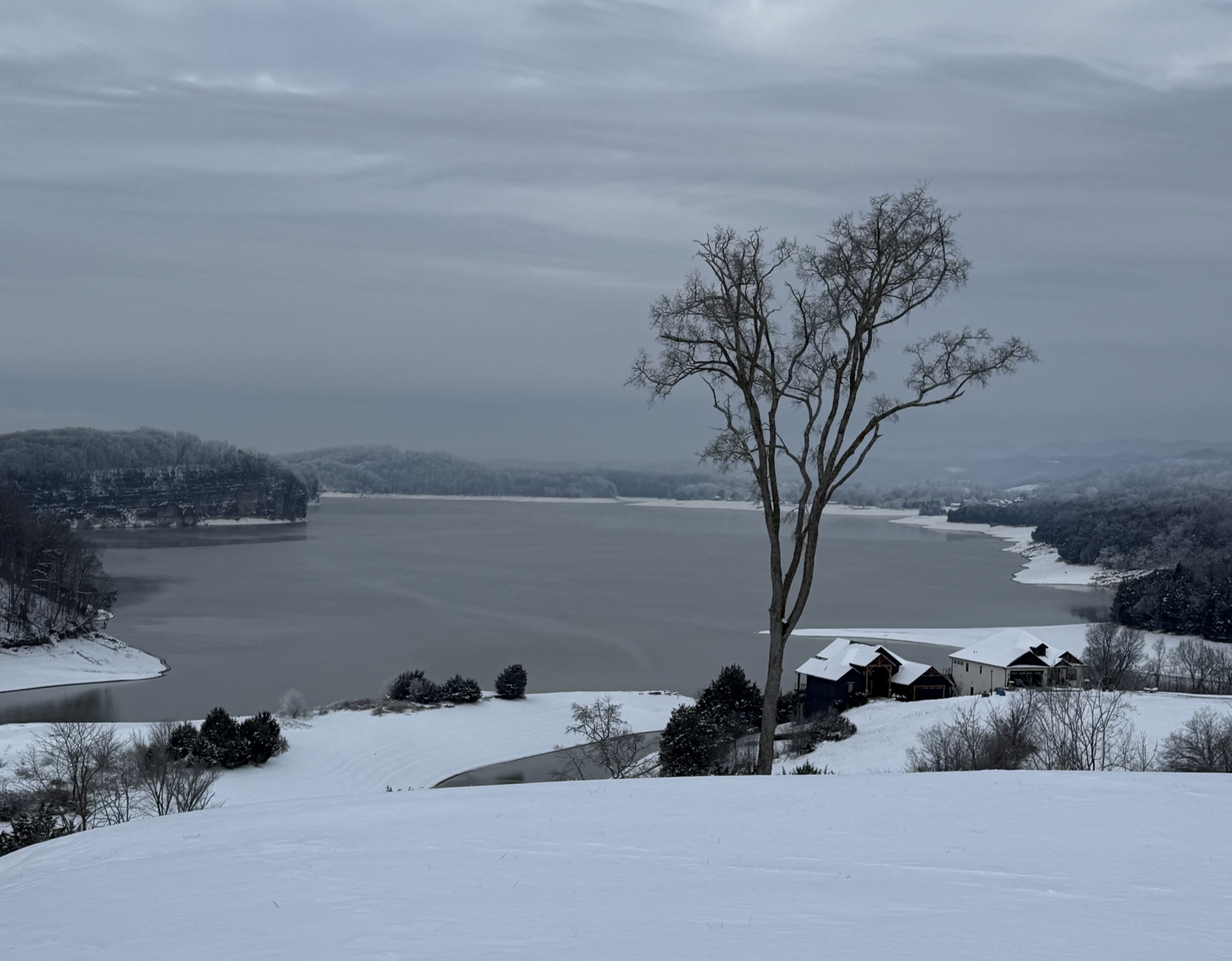
This was the view from my neighbor’s house earlier this morning. Overlooking Cherokee Lake. For reference I’m at the corner of Hamblen, Hawkins, and Grainger Co. Ice is beginning to form in spots on the lake. I’ve only seen that 1 or 2 times since we’ve lived here. An impressive airmass for sure!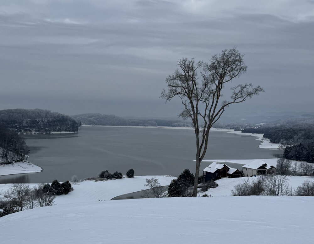
-
Jan 30th-February 1st 2026 Arctic Blast/ULL Snow OBS Thread.
Jed33 replied to John1122's topic in Tennessee Valley
It’s currently 1° at the house, and I’m on a hill above the lake. Most certainly is below zero around the sheltered valleys. I also see TRI is reporting -6° Wow! MRX issued a cold weather advisory for just the temperatures as they said they didn’t expect it to get this cold. As others have said, it’s the power of a healthy snowpack. It will do it every time. -
Jan 30th-February 1st 2026 Arctic Blast/ULL Snow OBS Thread.
Jed33 replied to John1122's topic in Tennessee Valley
There was actually a thin band that moved from NE to SW across Hamblen Co this morning. When I woke up around 6 I noticed it was snowing again. Picked up a tiny dusting on top of some cleaned off surfaces. The band slowly crawled SW and has all but broken up near the Jefferson Hamblen Co. line. I’m not sure what contributed to it other than possibly Cherokee Lake? We’ve seen that before a few times in these arctic setups. -
Jan 30th-February 1st 2026 Arctic Blast/ULL Snow OBS Thread.
Jed33 replied to John1122's topic in Tennessee Valley
Really curious to know how Carver fared in Kingsport? -
Jan 30th-February 1st 2026 Arctic Blast/ULL Snow OBS Thread.
Jed33 replied to John1122's topic in Tennessee Valley
Went out and measured again. A little over 6in now! Wow! -
Jan 30th-February 1st 2026 Arctic Blast/ULL Snow OBS Thread.
Jed33 replied to John1122's topic in Tennessee Valley
Just woke up and measured around 5 in the grass and a little over 4 on the walkway. Temp is 14! Let that sink in 14 with light borderline moderate at times snow. It’s not often at all you’ll get these conditions in Tennessee. We need to enjoy this one yall! This one is a top 5 for sure on the cold side.