
ThePhotoGuy
-
Posts
4,001 -
Joined
-
Last visited
Content Type
Profiles
Blogs
Forums
American Weather
Media Demo
Store
Gallery
Everything posted by ThePhotoGuy
-
Smoke definitively worse than yesterday. Visibility about 1.25 miles. Can’t see the Key Bridge on the Patapsco. Had my N95 on so I didn’t notice any smoke smell.
-
Not gonna lie but that would be pretty cool to see (yes, I know the health risks).
-
Low visibility with the smoke. Can’t even see across the Patapsco River. Burning odor too.
-
Currently 90.8 after a high of 91.7.
-
Bought a weather station early last month. May 9th-31st Highest Temp: 84 Lowest Temp: 47.8 Highest Wind Gust: 12.9 mph Rain Total: 0.48
-
Just a few sprinkles today. Went to Lake Shore area of Pasadena earlier today and a decent rain shower moved through.
-
Beautiful sunny afternoon even though it is a little humid out there.
-
Yesterday's view as the storm moved through...
-
Radio traffic definitely had west coast vibes. Forestry does prescribed burns in the environmental areas on state lands, It would be interesting to know when the last time they did Soldiers Delight?
-
Live Helicopter Footage: https://twitter.com/i/broadcasts/1zqKVPrgayZJB?fbclid=IwAR3LUxlDrlHhehTOSOI7wd3XG4zqvkbRVkrgQj5ANivbJb4pCwQ2CAq9aEM 5th Alarm Requested. Maryland Forestry assisting.
-
Winds started to really pick up at 900. Lights have been flickering.
-
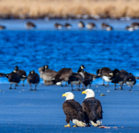
Cool! Its been pretty slow this "winter" for Bald Eagles in my area. In recent years, I would often see Bald Eagles flying over the Patapsco River and the Chesapeake Bay but the first one I saw this year was last weekend at Downs Park. I think a lot of it had to do with the lack of migratory ducks in the area this year. I have been wanting to go to the McKeldin area. I have seen some neat pictures of the rapids/waterfalls there. I usually go to the Avalon/Orange Grove areas of Patapsco for photos/hiking.
-
Saw my first Osprey of the season today flying over the Patapsco River!
-
Surprised to see some sleet mixed in in Pasadena. Wasn’t expecting that. 42 degrees
-
Flurries. 36 degrees.
-
Beautiful sunset tonight. Wasn’t expecting it with all the clouds this afternoon.
- 302 replies
-
- 16
-

-
Beautiful sunset glow tonight. This was 35 minutes post sunset and glow was still going strong!
-

December 22-23, 2022: Warm Rain to Arctic Chill
ThePhotoGuy replied to WxUSAF's topic in Mid Atlantic
Low of 7.2 in Pasadena -
December 22-23, 2022: Warm Rain to Arctic Chill
ThePhotoGuy replied to WxUSAF's topic in Mid Atlantic
A balmy 11.8 degrees right off of the Patapsco River in Pasadena! -
December 22-23, 2022: Warm Rain to Arctic Chill
ThePhotoGuy replied to WxUSAF's topic in Mid Atlantic
Winds picking up in Pasadena. Calls for down wires picking up. A tree on a house in Glen Burnie and a tree on a shed in Severna Park. BGE giving three hour response etas. -
December 22-23, 2022: Warm Rain to Arctic Chill
ThePhotoGuy replied to WxUSAF's topic in Mid Atlantic
Snow flurries. 35.7 degrees. -
December 22-23, 2022: Warm Rain to Arctic Chill
ThePhotoGuy replied to WxUSAF's topic in Mid Atlantic
Woke up to a burst of sleet/rain & wind. Didn't last long but still neat to see. -
Last night's moonrise over White Rocks and the Patapsco River.
- 582 replies
-
- 17
-
