T. August
-
Posts
4,612 -
Joined
-
Last visited
Content Type
Profiles
Blogs
Forums
American Weather
Media Demo
Store
Gallery
Everything posted by T. August
-
 Really just hoping for a decent snow shower. Last time it snowed IMBY in November was 2018 if I remember correctly. I wanna say it was like 2-3”.
 -
Tropical Storm Debby: Mid-Atlantic Impacts
T. August replied to WxWatcher007's topic in Mid Atlantic
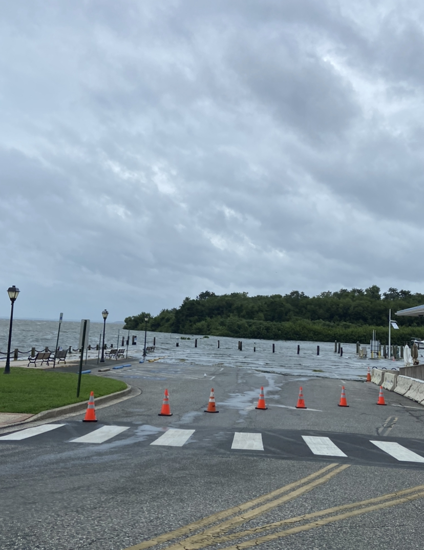
From this morning at City Park in Havre de Grace. This was when it was just starting. New waterline got to the crosswalk.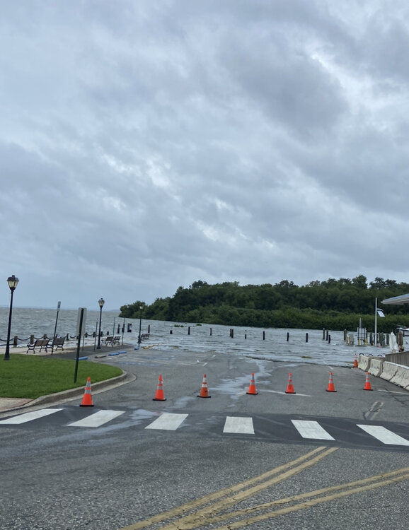
- 681 replies
-
- 10
-

-
Looks like APG recorded a gust of 78mph. I believe it. Could’ve been even higher. There are a dozen trees down here, with one currently leaning on the house lol.
-
Actually almost moderate briefly in Havre de Grace
-
I was thinking today how verified severe in any given backyard is nearly as rare as a HECS. I’ve only directly measured severe winds once (61 MPH. 2015?). Then in 2022 what I presume to be a microburst/tornado occurred, where nearly 10 trees came down in a 1-acre area. Are there any stats for the airports for severe? Do they track days with verified severe storms?
-
Mid-Atlantic Snow Totals Thread - Winter 2023-2024
T. August replied to mattie g's topic in Mid Atlantic
What’s your average? 30”? -
The Weekend Rule? Saturday 2/17 - The Icon Storm
T. August replied to DDweatherman's topic in Mid Atlantic
https://www.weather.gov/lwx/pnsmap?type=snow Mine is the depressing 1.5 in SE Harford County -
The Weekend Rule? Saturday 2/17 - The Icon Storm
T. August replied to DDweatherman's topic in Mid Atlantic
It’s amazing being on the water in the spring and summer but not sure it makes up for it lol. -
The Weekend Rule? Saturday 2/17 - The Icon Storm
T. August replied to DDweatherman's topic in Mid Atlantic
I’m gonna be sick -
Mid-Atlantic Snow Totals Thread - Winter 2023-2024
T. August replied to mattie g's topic in Mid Atlantic
2/17: 1.5 Total: 9.8 -
The Weekend Rule? Saturday 2/17 - The Icon Storm
T. August replied to DDweatherman's topic in Mid Atlantic
Just finished snowing. 1.5” exactly on the snow board. -
The Weekend Rule? Saturday 2/17 - The Icon Storm
T. August replied to DDweatherman's topic in Mid Atlantic
Snowing pretty well actually, with nothing on radar. Hoping for 1.5” after complaining lol. -
The Weekend Rule? Saturday 2/17 - The Icon Storm
T. August replied to DDweatherman's topic in Mid Atlantic
Some crazy reports to the northeast too… yeesh. -
The Weekend Rule? Saturday 2/17 - The Icon Storm
T. August replied to DDweatherman's topic in Mid Atlantic
Didn’t do a final measurement yet but looks like it’s over an inch. I shouldn’t have complained so soon. -
The Weekend Rule? Saturday 2/17 - The Icon Storm
T. August replied to DDweatherman's topic in Mid Atlantic
Not even an inch in Havre de Grace. I had 2” as a benchmark after all of the negative guidance came in and figured that would be realistic. Nope. Snowing lightly still. -
The Weekend Rule? Saturday 2/17 - The Icon Storm
T. August replied to DDweatherman's topic in Mid Atlantic
Yikes on the nams. Going to bed. -
The Weekend Rule? Saturday 2/17 - The Icon Storm
T. August replied to DDweatherman's topic in Mid Atlantic
38/22 in Havre de Grace -
The Weekend Rule? Saturday 2/17 - The Icon Storm
T. August replied to DDweatherman's topic in Mid Atlantic
That’s super cool and also super depressing -
The Weekend Rule? Saturday 2/17 - The Icon Storm
T. August replied to DDweatherman's topic in Mid Atlantic
42/20 in Havre de Grace. Current temps look pretty close to most guidance. -
The Weekend Rule? Saturday 2/17 - The Icon Storm
T. August replied to DDweatherman's topic in Mid Atlantic
Model always lol -
The Weekend Rule? Saturday 2/17 - The Icon Storm
T. August replied to DDweatherman's topic in Mid Atlantic
3k is warm… 33° during the heaviest for the cities. -
The Weekend Rule? Saturday 2/17 - The Icon Storm
T. August replied to DDweatherman's topic in Mid Atlantic
I imagine the majority of 12z was factored in, with the exception of the euro. Still a little more bullish than I expected. -
The Weekend Rule? Saturday 2/17 - The Icon Storm
T. August replied to DDweatherman's topic in Mid Atlantic
Is any guidance really showing those totals in such a wide area though? -
The Weekend Rule? Saturday 2/17 - The Icon Storm
T. August replied to DDweatherman's topic in Mid Atlantic
New expected totals from LWX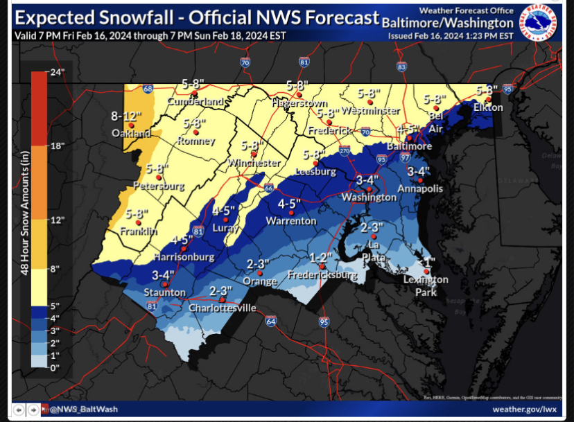
-
The Weekend Rule? Saturday 2/17 - The Icon Storm
T. August replied to DDweatherman's topic in Mid Atlantic
May be a bit ambitious for my area towards Baltimore, but I’m hoping for a warning-level event. Would be the first here since 2019.