

40/70 Benchmark
-
Posts
77,972 -
Joined
-
Last visited
Content Type
Profiles
Blogs
Forums
American Weather
Media Demo
Store
Gallery
Everything posted by 40/70 Benchmark
-

2025-2026 ENSO
40/70 Benchmark replied to 40/70 Benchmark's topic in Weather Forecasting and Discussion
Not necessarily....it depends where it's located because a strong vortex located in the vicinity of James Bay is the coldest pattern there is. -
2025-2026 ENSO
40/70 Benchmark replied to 40/70 Benchmark's topic in Weather Forecasting and Discussion
@Stormchaserchuck1I am just north of that 60, where the arrow is pointing.....60% shot at 3"+ according to the EPS.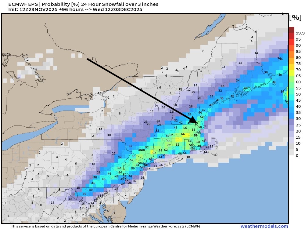
-
First Winter Storm to kickoff 2025-26 Winter season
40/70 Benchmark replied to Baroclinic Zone's topic in New England
Yes, this was never going to be more than 8" IMO. -
First Winter Storm to kickoff 2025-26 Winter season
40/70 Benchmark replied to Baroclinic Zone's topic in New England
I just gave it a quick eyeball....matched up generally speaking, I didn't compare it that specifically. -
First Winter Storm to kickoff 2025-26 Winter season
40/70 Benchmark replied to Baroclinic Zone's topic in New England
Whooooosh. -
First Winter Storm to kickoff 2025-26 Winter season
40/70 Benchmark replied to Baroclinic Zone's topic in New England
I'm just mocking Kevin's inane outbursrs. -
First Winter Storm to kickoff 2025-26 Winter season
40/70 Benchmark replied to Baroclinic Zone's topic in New England
The whole thing has gone to crap. -
First Winter Storm to kickoff 2025-26 Winter season
40/70 Benchmark replied to Baroclinic Zone's topic in New England
DT's First Call map looks like mine. -
2025-2026 ENSO
40/70 Benchmark replied to 40/70 Benchmark's topic in Weather Forecasting and Discussion
I'm not doom and gloom...I went 19-29" for you on the season. I'm just not as optimistic about December as the consensus for your area. -
First Winter Storm to kickoff 2025-26 Winter season
40/70 Benchmark replied to Baroclinic Zone's topic in New England
I would be fine with an advisory event. -
2025-2026 ENSO
40/70 Benchmark replied to 40/70 Benchmark's topic in Weather Forecasting and Discussion
Maybe I will be wrong on some aspects, which is fine...I'll learn from it....but all I ask from those who comment on my work is to accurately reference what the forecast was. -
2025-2026 ENSO
40/70 Benchmark replied to 40/70 Benchmark's topic in Weather Forecasting and Discussion
Keep thinking what? It's not subjective...I told you what my forecast was...that is objective fact. -
2025-2026 ENSO
40/70 Benchmark replied to 40/70 Benchmark's topic in Weather Forecasting and Discussion
I used December 2000 as an analog for the warming in that it would narrowly miss a reversal, but also mentioned December 1981 as an example if it were to actually reverse. I said that the MJO would staddle the border of MJO phase 8 and perhaps make it into phase 8 at a reduced amplitude, which would allow other factors to potentially modulate the pattern. And I'm not sure how in the hell you are grading the nuances of the 500mb composite for a month that has yet to begin. You are absolutely desperate for snow in Central Park, I get it. -
2025-2026 ENSO
40/70 Benchmark replied to 40/70 Benchmark's topic in Weather Forecasting and Discussion
I stopped reading your response right there. Either you didn't actually read my outlook, or you're illiterate to some extent. -
First Winter Storm to kickoff 2025-26 Winter season
40/70 Benchmark replied to Baroclinic Zone's topic in New England
Just see how EPS trended. -
2025-2026 ENSO
40/70 Benchmark replied to 40/70 Benchmark's topic in Weather Forecasting and Discussion
I have explained my forecast rationale in quite vivid detail, so if the logic is still lost on you, the issue is not mine. I will be sure to pay particularly close attention to how much the I 95 cities south of Boston receive in December. Good luck- -
2025-2026 ENSO
40/70 Benchmark replied to 40/70 Benchmark's topic in Weather Forecasting and Discussion
It would probably be a pattern that would still stack snow in NNE, but my area points southward would struggle on the cp. -
2025-2026 ENSO
40/70 Benchmark replied to 40/70 Benchmark's topic in Weather Forecasting and Discussion
Yea, the cold 500mb is what I was getting at by "cold in se Canda", which I was supremely confident would be in play this year, in sharp contrast to the past decade. -
2025-2026 ENSO
40/70 Benchmark replied to 40/70 Benchmark's topic in Weather Forecasting and Discussion
I still think there will be some sort of break prior to Xmas....also not huge on mid atlantic snowfall this month...at least not in the lower terrain on the coastal plane. -
2025-2026 ENSO
40/70 Benchmark replied to 40/70 Benchmark's topic in Weather Forecasting and Discussion
I think so...which is why I wanted you to bet. I was very confident in a fast start to the month based on my analogs. -
First Winter Storm to kickoff 2025-26 Winter season
40/70 Benchmark replied to Baroclinic Zone's topic in New England
Sell early phase. -
2025-2026 ENSO
40/70 Benchmark replied to 40/70 Benchmark's topic in Weather Forecasting and Discussion
I probably rushed the PV recovery, which I can live with...the bigger deal is getting the Pacific trough transition correct. -
First Winter Storm to kickoff 2025-26 Winter season
40/70 Benchmark replied to Baroclinic Zone's topic in New England
I wouldn't worry about the OP details yet...like where we stand. -
First Winter Storm to kickoff 2025-26 Winter season
40/70 Benchmark replied to Baroclinic Zone's topic in New England
Good look. -
First Winter Storm to kickoff 2025-26 Winter season
40/70 Benchmark replied to Baroclinic Zone's topic in New England
I don't think it is..let's see what verifies. It's not zero chance, though....any time you get a weak PV the guard has to be...which is why I said slight chance of a KU between Dec 1 and 15, but I think the better window is late season.


